Howard is a rural town and locality in the Fraser Coast Region, Queensland, Australia.[2][3] It is a southern boundary of the Dundaburra peoples of the Northern Kabi Kabi Isis districts and surrounds. It is located 284 kilometres (176mi) north of Brisbane and 37 kilometres (23mi) west of Hervey Bay. In the 2021 census, the locality of Howard had a population of 1,394 people.[1]
Torbanlea is on the east side of the Burrum River and Howard on the west side of the Burrum River. The distance between the towns is 5.1 kilometres (3.2 miles), and they were known as twin towns.[citation needed]
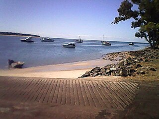
Maria Creek runs through the town and discharges into the Burrum River downstream of the Howard boat ramp.
The Bruce Highway passes through the locality in an east–west direction skirting the edge of the town. Queensland's North Coast railway line passes in a NW-SE direction through the town centre. The main streets of Howard are Steley and William.[4]
History
The town was originally known as Steley (after Abel Steley) but was renamed after William Howard, a pioneer in coal mining in the Burrum area.[2][5][6]
Abel Steley commenced coal mining in the area in 1856. After a series of setbacks, he eventually established the successful Beauford Colliery and the Queensland Collieries Company.[7]
In 1877 George Howard and his son William established the Howard Colliery.[8]
From the 1860s the coal from the Burrum coalfields was transported to the port at Maryborough for loading onto boats.[9] From 1877 the 44-ton stern-wheel steamer Barbara and Jane commenced navigating the Burrum River to transport the coal to Maryborough.[10] In 1883 the railway line from Maryborough to the Burrum River opened, and was known as the Burrum line. However until the railway bridge was opened in April 1884, the coal could not be transported by this means.[11][12][13] Over the decades, various plans were mooted to move the coal, either through a proposed port at the mouth of the Burrum River, or through the deep water port at Urangan. Burrum coalfields coal supplied the Howard power station which operated from 1951 to 1980.[14][15]
On Sunday 30 March 1884 a Primitive Methodist Church was opened in Howard.[24][25] With the amalgamation of the various Methodist denominations c 1900, it became the Howard Methodist Church and with the amalgamation of the Methodist Church into the Uniting Church in Australia in 1977, it became the Howard Uniting Church.[26][27]
The 140th anniversary of the Howard Uniting Church and also VanCootens Grocery, Hardware & Stockfeed was celebrated with a Community Day on 7 September 2024.[28]
The Howard War Memorial was unveiled by Colin Rankin on 17 December 1921. Unusually for an Australian war memorial, the statue was made in Italy and depicts a soldier in Italian uniform.[30]
In May 1984, the Bruce Highway bypass was opened. Previously the highway had run through the town on Robertson Street. Neighbouring Torbanlea was also bypassed as part of same project.[31]
The Howard Library opened in 2000 and underwent a major refurbishment in 2014.[32]
The historic wooden foot bridge over the railway line in Steley Street near the C.W.A Hall was demolished in 2016 as it became too expensive to maintain. It was a popular spot for photographing trains traveling north or south.[citation needed]
Demographics
In the 2011 census, the locality of Howard had a population of 1,364 people.[33]
In the 2016 census, the locality of Howard had a population of 1,359 people.[34]
In the 2021 census, the locality of Howard had a population of 1,394 people.[1]
Howard State School is a government primary (Prep–6) school for boys and girls at 108 William Street (25°19′19″S152°33′28″E / 25.3219°S 152.5578°E / -25.3219; 152.5578 (Howard State School)).[37][38] In 2012 the school had an enrolment of 177 students with 12 teachers (11.3 full-time equivalent).[39][40] In 2018, the school had an enrolment of 108 students with 8 teachers (7 full-time equivalent) and 8 non-teaching staff (5 full-time equivalent).[41]
There is no secondary school in Howard; the nearest are in Childers to the north-west, Hervey Bay to the east and Maryborough to the south.
Amenities
Queensland Country Womens Association Hall, Howard, with a Walk of Achievers steel planter box in front. 2024
Steley Street contains the skatepark, children's playground, kindergarten, respite centre, and Men's Shed, located on the southern side of the William Sreet intersection, as is the Howard Sawmill (producers of kiln dried Queensland hardwood). The drapery and patchwork store, hairdresser, and VanCootens Grocery, Hardware & Stockfeed are on the northern side, as is the QCWA hall (25°19′00″S152°33′42″E / 25.3167°S 152.5616°E / -25.3167; 152.5616 (Queensland Country Women's Association)).[42]
A 48-hour stop over for RVs is located in Steley Street opposite the Community Centre and the Howard Sub Branch of the RSL.[citation needed]
A walk around the streets of Howard will reveal information boards about the War Memorial, mining history and the naming of both Bellert Park and the Tom & Minnie Young Memorial Hall.[53]
The Burrum District Museum is open Tuesday and Wednesday 9am – 12 noon, and Saturdays 8am – 12noon.[54][55]
Brooklyn House is at 23 William Street, Howard and is open Thursday to Sunday, 10am – 3pm.[56]
Walk of Achievers steel planter box in the shape of a coal bucket in Howard, Queensland. 2024
The Walk of Achievers honours fourteen former residents.[57]
Burrum Coal Discovery Festival (Coalfest) is held annually in July.[58][59]
The Howard Country Market is held on the first Saturday of every month except January at the community centre. This market is the largest on the Fraser Coast with well over 100 stalls selling a huge variety of goods.[60]
Annabelle Rankin, the first woman from Queensland to sit in the Parliament of Australia, the first woman to have a federal portfolio and the first woman to be appointed head of a foreign mission. She lived in Brooklyn House.
↑ "Howard, Fraser Coast Hinterland". Fraser Coast Attractions:: Action, Adventure, Heritage, Fun!. Archived from the original on 17 September 2024. Retrieved 17 September 2024.
↑ Council, Fraser Coast Regional. "Coalfest 2024". Fraser Coast Regional Council. Archived from the original on 18 September 2024. Retrieved 18 September 2024.
Maryborough is a city and a suburb in the Fraser Coast Region, Queensland, Australia. In the 2021 census, the suburb of Maryborough had a population of 15,287 people.
Biggenden is a rural town and locality in the North Burnett Region, Queensland, Australia. In the 2021 census, the locality of Biggenden had a population of 788 people.
Burnett Heads is a coastal town and locality in the Bundaberg Region, Queensland, Australia. In the 2021 census, the locality of Burnett Heads had a population of 2,908 people.
River Heads is a coastal town and locality in the Fraser Coast Region, Queensland, Australia. In the 2021 census, the locality of River Heads had a population of 2,044 people.
The Shire of Woocoo was a local government area located in the Wide Bay–Burnett region of Queensland, Australia, containing the rural residential area to the west of the town of Maryborough, and surrounding countryside. The shire covered an area of 2,007.9 square kilometres (775.3 sq mi), and existed as a local government entity from 1914 until 2008, when it was amalgamated with the City of Maryborough, City of Hervey Bay and the 1st and 2nd divisions of the Shire of Tiaro to form the Fraser Coast Region.
The Fraser Coast Region is a local government area in the Wide Bay–Burnett region of Queensland, Australia, about 250 kilometres (160 mi) north of Brisbane, the state capital. It is centred on the twin cities of Hervey Bay and Maryborough and also contains K'gari. It was created in 2008 from a merger of the Cities of Maryborough and Hervey Bay and the Shires of Woocoo and most of Tiaro. The resident population at the 2021 census was 111,032 and the estimated population in 2023 was 117,940.
Torquay is a coastal suburb in Hervey Bay in the Fraser Coast Region, Queensland, Australia. In the 2021 census, Torquay had a population of 6,533 people.
Theebine is a rural town and locality split between the Gympie Region and the Fraser Coast Region, both in Queensland, Australia.
Urangan is a coastal suburb of the city of Hervey Bay in the Fraser Coast Region, Queensland, Australia. In the 2021 census, Urangan had a population of 10,988 people.
Tinana is a rural town and locality in the Fraser Coast Region, Queensland, Australia. In the 2021 census, the locality of Tinana had a population of 5,872 people.
Torbanlea is a rural town and locality in the Fraser Coast Region, Queensland, Australia. In the 2021 census, the locality of Torbanlea had a population of 841 people.
Burrum Heads is a coastal town and locality in the Fraser Coast Region, Queensland, Australia. In the 2021 census, the locality of Burrum Heads had a population of 2,538 people.
Bauple is a rural town and locality in the Fraser Coast Region, Queensland, Australia. In the 2021 census, the locality of Bauple had a population of 745 people.
Dallarnil is a rural town and locality in the North Burnett Region, Queensland, Australia. In the 2021 census, the locality of Dallarnil had a population of 245 people.
Granville is a rural locality in the Fraser Coast Region, Queensland, Australia. It is a suburb of Maryborough. In the 2021 census, Granville had a population of 2,532 people.
St Helens is a rural locality in the Fraser Coast Region, Queensland, Australia. In the 2021 census, St Helens had a population of 123 people.
Magnolia is a rural locality in the Fraser Coast Region, Queensland, Australia. In the 2021 census, Magnolia had a population of 115 people.
Munna Creek is a locality split between the Fraser Coast Region and the Gympie Region, in Queensland, Australia. In the 2021 census, Munna Creek had a population of 22 people.
Gungaloon is a locality in the Fraser Coast Region, Queensland, Australia. In the 2021 census, Gungaloon had a population of 27 people.
Maryborough–Hervey Bay Road is a continuous 44.9 kilometres (27.9 mi) road route in the Fraser Coast region of Queensland, Australia. The entire route is signed as State Route 57. It is a state-controlled regional road.
This page is based on this Wikipedia article Text is available under the CC BY-SA 4.0 license; additional terms may apply. Images, videos and audio are available under their respective licenses.


