Teddington, Queensland

Last updated

Teddington
Queensland
Australia Queensland location map.svg
Red pog.svg
Teddington
Coordinates 25°39′50″S152°39′40″E / 25.6638°S 152.6611°E / -25.6638; 152.6611 (Teddington (centre of locality))
Population236 (2021 census) [1]
 • Density8.84/km2 (22.89/sq mi)
Postcode(s) 4650
Area26.7 km2 (10.3 sq mi)
Time zone AEST (UTC+10:00)
Location
LGA(s) Fraser Coast Region
State electorate(s) Maryborough
Federal division(s) Wide Bay
Suburbs around Teddington:
Tinana South Tinana South Bidwill
Glenorchy Teddington Magnolia
Owanyilla Tiaro Tuan Forest

Teddington is a rural locality in the Fraser Coast Region, Queensland, Australia. [2] In the 2021 census, Teddington had a population of 236 people. [1]

Contents

Geography

The locality is bounded to the east, south-east, and south by Tinana Creek, a tributary of the Mary River. [3] Teddington Weir impounds the creek at 25°39′00″S152°39′58″E / 25.65013°S 152.66601°E / -25.65013; 152.66601 (Teddington Weir) ; it is operated by the Fraser Coast Regional Council. [3] [4]

The elevation ranges from 10 to 50 metres (33 to 164 ft) above sea level with the lower elevations along the creek to the east. [3]

The land use is predominantly crop growing (mostly sugarcane) with some grazing on native vegetation. There is also rural residential housing, mostly along Philip Drive in the north-west of the locality. [3]

History

In March 1913, local residents requested the Queensland Government provide a school for the local area, pointing out that children were having to walk three or four miles to the school in Tinana. Local sugarcane farmer John Parke donated 5 acres (2.0 ha) of his property "Spring Grove" for the Teddington State School (as it was originally proposed to be named). It was built as an open-air school (a less-enclosed building). [5] [6] [7] The school was officially opened as Parke State School on 24 October 1914 by John Douglas Story, the Under-Secretary for the Department of Education. Story praised the open-air design as being both healthier for the students and cheaper for the government, as small rural schools were not always permanent due to fluctuations in the local population. [8] [9] The school admitted its first 21 students on 11 November 1914; the first teacher was Grace Smith. On 24 November 1914, it was officially confirmed that the school would be known Parke State School in honour of Parke who was killed in a farm accident in November 1913 (although this name was already in unofficial use at time of its opening). [10] [11] [12] [13] [14] [15] The school is now within the boundaries of the neighbouring locality of Tinana South to the north. [16]

Prior to 2008, the locality of Teddington was split between the local government areas of Shire of Tiaro and Shire of Woocoo. However, in 2008, both of these shires were absorbed into the new Fraser Coast Region, reuniting the locality. [2]

Demographics

In the 2016 census, Teddington had a population of 237 people. [17]

In the 2021 census, Teddington had a population of 236 people. [1]

Education

There are no schools in Teddington. The nearest government primary schools are Parke State School in neighbouring Tinana South to the north and Tiaro State School in neighbouring Tiaro to the south. The nearest government secondary school is Maryborough State High School in Maryborough to the north. [18]

Related Research Articles

<span class="mw-page-title-main">Maryborough, Queensland</span> City in Queensland, Australia

Maryborough is a city and a suburb in the Fraser Coast Region, Queensland, Australia. At the 2021 Census, the suburb of Maryborough had a population of 15,287.

<span class="mw-page-title-main">Biggenden</span> Town in Queensland, Australia

Biggenden is a rural town and locality in the North Burnett Region, Queensland, Australia. In the 2021 census, the locality of Biggenden had a population of 788 people.

<span class="mw-page-title-main">Tiaro, Queensland</span> Town in Queensland, Australia

Tiaro is a rural town and locality in the Fraser Coast Region, Queensland, Australia. In the 2021 census, the locality of Tiaro had a population of 778 people.

<span class="mw-page-title-main">Shire of Tiaro</span> Local government area in Queensland, Australia

The Shire of Tiaro was a local government area in the Wide Bay–Burnett region of Queensland, Australia, between the regional cities of Gympie and Hervey Bay about 220 kilometres (137 mi) north of the state capital, Brisbane. The shire covered an area of 2,185.3 square kilometres (843.7 sq mi), and existed as a local government area from 1879 until 2008, when it was dissolved and split between two new local government areas, the Gympie Region and the Fraser Coast Region.

<span class="mw-page-title-main">Shire of Woocoo</span> Local government area in Queensland, Australia

The Shire of Woocoo was a local government area located in the Wide Bay–Burnett region of Queensland, Australia, containing the rural residential area to the west of the town of Maryborough, and surrounding countryside. The shire covered an area of 2,007.9 square kilometres (775.3 sq mi), and existed as a local government entity from 1914 until 2008, when it was amalgamated with the City of Maryborough, City of Hervey Bay and the 1st and 2nd divisions of the Shire of Tiaro to form the Fraser Coast Region.

<span class="mw-page-title-main">City of Maryborough (Queensland)</span> Local government area in Queensland, Australia

The City of Maryborough was a local government area located in the Wide Bay–Burnett region of Queensland, Australia, containing the urban locality of Maryborough as well as the southern half of Fraser Island. The City covered an area of 1,233.9 square kilometres (476.4 sq mi), and existed as a local government entity from 1861 until 2008, when it was amalgamated with the City of Hervey Bay, Shire of Woocoo and the 1st and 2nd divisions of the Shire of Tiaro to form the Fraser Coast Region.

<span class="mw-page-title-main">City of Hervey Bay</span> Local government area in Queensland, Australia

The City of Hervey Bay was a local government area located in the Wide Bay–Burnett region of Queensland, Australia, containing the urban centre of Hervey Bay as well as the northern half of Fraser Island. The City covered an area of 2,356.3 square kilometres (909.8 sq mi), and existed as a local government entity in various forms from 1879 until 2008, when it was amalgamated with the City of Maryborough, Shire of Woocoo and the 1st and 2nd divisions of the Shire of Tiaro to form the Fraser Coast Region.

<span class="mw-page-title-main">Brooweena, Queensland</span> Town in Queensland, Australia

Brooweena is a rural town and locality in the Fraser Coast Region, Queensland, Australia. In the 2021 census, the locality of Brooweena had a population of 91 people.

<span class="mw-page-title-main">Tinana, Queensland</span> Town in Queensland, Australia

Tinana is a rural town and locality in the Fraser Coast Region, Queensland, Australia. In the 2021 census, the locality of Tinana had a population of 5,872 people.

<span class="mw-page-title-main">Shire of Tinana</span>

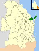
The Shire of Tinana is a former local government area in the Wide Bay–Burnett area of Queensland, Australia. It is centred on Tinana, on the southern bank of the Mary River, with the Borough of Maryborough on the northern bank. It existed from 1880 to 1917.

Ernest Henry Collet Clayton was a member of the Queensland Legislative Assembly.

<span class="mw-page-title-main">Bauple, Queensland</span> Town in Queensland, Australia

Bauple is a rural town and locality in the Fraser Coast Region, Queensland, Australia. In the 2016 census the locality of Bauple had a population of 644 people.

Tinana South is a rural locality in the Fraser Coast Region, Queensland, Australia. In the 2021 census, Tinana South had a population of 545 people.

Boompa is a rural locality in the Fraser Coast Region, Queensland, Australia. In the 2021 census, Boompa had a population of 89 people.

Glen Echo is a rural locality in the Gympie Region, Queensland, Australia. In the 2021 census, Glen Echo had a population of 49 people.

Moonford is a rural town and locality in the North Burnett Region, Queensland, Australia. In the 2016 census, the locality of Moonford had a population of 160 people.

<span class="mw-page-title-main">Teebar, Queensland</span> Suburb of Fraser Coast Region, Queensland, Australia

Teebar is a rural locality in the Fraser Coast Region, Queensland, Australia. In the 2021 census, Teebar had a population of 59 people.

Mount Urah is a rural locality in the Fraser Coast Region, Queensland, Australia. In the 2021 census, Mount Urah had a population of 49 people.

<span class="mw-page-title-main">Grahams Creek, Queensland</span> Suburb of Fraser Coast Region, Queensland, Australia

Grahams Creek is a rural locality in the Fraser Coast Region, Queensland, Australia. In the 2021 census, Grahams Creek had a population of 149 people.

Wilson Valley is a rural locality in the North Burnett Region, Queensland, Australia. In the 2021 census, Wilson Valley had a population of 20 people.

References

  1. 1 2 3 Australian Bureau of Statistics (28 June 2022). "Teddington (SAL)". 2021 Census QuickStats. Retrieved 28 February 2023. OOjs UI icon edit-ltr-progressive.svg
  2. 1 2 "Teddington – locality in Fraser Coast Region (entry 46734)". Queensland Place Names. Queensland Government . Retrieved 10 June 2019.
  3. 1 2 3 4 "Queensland Globe". State of Queensland . Retrieved 25 January 2024.
  4. "Water Supply Scheme". Fraser Coast Regional Council. Archived from the original on 27 November 2023. Retrieved 25 January 2024.
  5. "NEW STATE SCHOOL". Maryborough Chronicle, Wide Bay And Burnett Advertiser . No. 12, 458. Queensland, Australia. 9 April 1913. p. 5. Archived from the original on 26 January 2024. Retrieved 25 January 2024 via National Library of Australia.
  6. "Advertising". The Bundaberg Mail And Burnett Advertiser . Vol. 44, no. 5386. Queensland, Australia. 5 August 1914. p. 3. Archived from the original on 26 January 2024. Retrieved 25 January 2024 via National Library of Australia.
  7. "TENDERS' ACCEPTED". Daily Standard . No. 536. Queensland, Australia. 2 September 1914. p. 6 (SECOND EDITION). Archived from the original on 26 January 2024. Retrieved 25 January 2024 via National Library of Australia.
  8. "THE NEW PARKE STATE SCHOOL". Maryborough Chronicle, Wide Bay And Burnett Advertiser . No. 12, 930. Queensland, Australia. 26 October 1914. p. 3. Archived from the original on 25 January 2024. Retrieved 25 January 2024 via National Library of Australia.
  9. "Open Air Schools". The Telegraph . No. 13, 083. Queensland, Australia. 26 October 1914. p. 2 (SECOND EDITION). Archived from the original on 25 January 2024. Retrieved 25 January 2024 via National Library of Australia.
  10. "Welcome to Parke State School". Parke State School. 23 January 2019. Archived from the original on 19 August 2019. Retrieved 25 January 2024.
  11. "History". Parke State School. 11 February 2019. Archived from the original on 24 March 2019. Retrieved 26 November 2023.
  12. "THE NEW PARKE STATE SCHOOL". Maryborough Chronicle, Wide Bay and Burnett Advertiser . No. 12, 930. Queensland, Australia. 26 October 1914. p. 3. Archived from the original on 25 January 2024. Retrieved 20 August 2019 via National Library of Australia.
  13. "OBITUARY". Maryborough Chronicle, Wide Bay and Burnett Advertiser . No. 12, 644. Queensland, Australia. 12 November 1913. p. 5. Archived from the original on 26 November 2023. Retrieved 20 August 2019 via National Library of Australia.
  14. "Agency ID 5609, Parke State School". Queensland State Archives . Retrieved 25 January 2024.
  15. Queensland Family History Society (2010), Queensland schools past and present (Version 1.01 ed.), Queensland Family History Society, ISBN   978-1-921171-26-0
  16. "Layers: Locality; Schools and school catchments". Queensland Globe. Queensland Government. Archived from the original on 19 December 2017. Retrieved 25 January 2024.
  17. Australian Bureau of Statistics (27 June 2017). "Teddington (SSC)". 2016 Census QuickStats. Retrieved 20 October 2018. OOjs UI icon edit-ltr-progressive.svg
  18. "Layers: Locality; Schools and school catchments". Queensland Globe. Queensland Government. Archived from the original on 19 December 2017. Retrieved 25 January 2024.