Huff Archeological Site | |
 | |
  | |
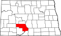
| Nearest city | Huff, North Dakota |
|---|---|
| NRHP reference No. | 80002920 |
| Significant dates | |
| Added to NRHP | July 23, 1980 |
| Designated NHL | February 18, 1997 |
The Huff Archeological Site is a prehistoric Mandan village in North Dakota dated around 1450 AD. [1] It was discovered in the early 1900s. [2] The site has been designated a National Historic Landmark, [3] and is one of the best preserved sites of the period. [2]