Hugoton Gas Field is a large natural gas field in the U.S. states of Kansas, Oklahoma, and Texas. Its name is derived from the town of Hugoton, Kansas, near which the Hugoton Field was first discovered.
Contents

Hugoton Gas Field is a large natural gas field in the U.S. states of Kansas, Oklahoma, and Texas. Its name is derived from the town of Hugoton, Kansas, near which the Hugoton Field was first discovered.
Natural gas in the Hugoton area was first discovered in 1922 in the Boles #1 well, in Seward County, two miles west of Liberal. [2] The well was drilled in 1919 to a depth of 2,919 feet by the Defenders Petroleum and Traders Oil and Gas Company, but was shut in for three years because it did not find oil. In 1922 the well was completed as a gas well, but there was little demand for natural gas in the area and it was years before another gas well was drilled in the field. [3]
In 1927, gas was discovered at the Independent Oil and Gas Company's Crawford No. 1, [4] [2] about 2,600 feet (790 meters) below the surface southwest of Hugoton, Kansas, in Stevens County. This is now considered the center of the Hugoton Field. By the end of 1928, five wells had been drilled in the field and the first pipeline was transporting gas to local markets. In 1929, Argus Pipe Line Company started construction of a pipeline to furnish gas to Dodge City, Kansas. Construction of major pipelines in the 1930s encouraged further drilling in the area. In 1977, gas was discovered at the Brown and Woolsey in the M. MAUNE, Well 1. [2]
In 2007, the Hugoton gas area produced 358 billion cubic feet of gas, making it the 5th largest source of natural gas in the United States. [5]
| Year | Production (mcf) | Wells | Cumulative (mcf) |
|---|---|---|---|
| 2015 | 110,193,159 | 7649 | 18,507,153,060 |
| 2016 | 98,405,418 | 7579 | 18,605,558,478 |
| 2017 | 91,796,374 | 7498 | 18,697,354,852 |
| 2018 | 85,872,232 | 7439 | 18,783,227,084 |
| 2019 | 81,029,876 | 7361 | 18,864,256,960 |
| 2020 | 76,725,624 | 7279 | 18,940,982,584 |
| 2021 | 35,424,523 | 7148 | 18,976,407,107 |
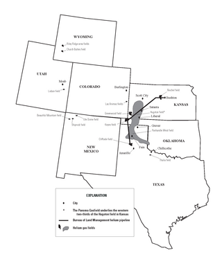
The natural gas in the Hugoton field of Kansas and Oklahoma, plus the Panhandle Field of Texas, contains unusually high concentrations of helium, from 0.3% to 1.9%. Because of the large size of these fields, they contain the largest reserves of helium in the United States. Helium is separated out as a byproduct from natural gas, from the Hugoton field, the Panhandle field in Texas, the Greenwood field in Kansas, and the Keyes field in Oklahoma. [6] Much of the recovered helium is piped to the National Helium Reserve in Amarillo, Texas, where it is stored underground in geologic formations for future use.
The Hugoton Field is a stratigraphic trap overlying a monocline, with the primary pay found in the Krider Dolomite of Permian age. [7] This dolomite and the overlying Herington dolomite make up the Wolfcampian carbonates. Above these carbonates is the Wichita, an anhydrite and dense dolomite forming the reservoir seal, which thins to the west. [8] Marine carbonates were being deposited from the Late Pennsylvanian until Early Permian when the western portion of the area was uplifted which resulted in erosion and the deposition of red clays and sands, the future red beds consisting of shales and sandstones. [7] Marine carbonate deposition followed, resulting in the interfingering of the red beds and carbonates, the basis of the stratigraphic trap and a tilted gas-water contact. [9]

The history of the petroleum industry in the United States goes back to the early 19th century, although the indigenous peoples, like many ancient societies, have used petroleum seeps since prehistoric times; where found, these seeps signaled the growth of the industry from the earliest discoveries to the more recent.

The Permian Basin is a large sedimentary basin in the southwestern part of the United States. The basin contains the Mid-continent oil field province. This sedimentary basin is located in western Texas and southeastern New Mexico. It reaches from just south of Lubbock, past Midland and Odessa, south nearly to the Rio Grande River in southern West Central Texas, and extending westward into the southeastern part of New Mexico. It is so named because it has one of the world's thickest deposits of rocks from the Permian geologic period. The greater Permian Basin comprises several component basins; of these, the Midland Basin is the largest, Delaware Basin is the second largest, and Marfa Basin is the smallest. The Permian Basin covers more than 86,000 square miles (220,000 km2), and extends across an area approximately 250 miles (400 km) wide and 300 miles (480 km) long.
The abiogenic petroleum origin is a fringe science which proposes that most of earth's petroleum and natural gas deposits were formed inorganically. Mainstream theories about the formation of hydrocarbons on earth point to an origin from the decomposition of long-dead organisms, though the existence of hydrocarbons on extraterrestrial bodies like Saturn's moon Titan indicates that hydrocarbons are sometimes naturally produced by inorganic means. Theories explaining the origin of petroleum as abiotic are generally not well accepted by the scientific community, and are rejected by most researchers and scientific theories on the subject.
Phillips Petroleum Company was an American oil company incorporated in 1917 that expanded into petroleum refining, marketing and transportation, natural gas gathering and the chemicals sectors. It was Phillips Petroleum that first found oil in the North Sea on December 23, 1969, at a position that was later named Ekofisk.
Jonah Field is a large natural gas field in the Green River Basin in Sublette County, Wyoming, in the United States. The field is approximately 32 miles (51 km) south of Pinedale and 65 miles (105 km) north of Rock Springs in southwestern Wyoming, and is estimated to contain 10.5 trillion cubic feet (300 km3) of natural gas. Managed by the Bureau of Land Management, the field has a productive area of 21,000 acres (8,500 ha).

The East Texas Oil Field is a large oil and gas field in east Texas. Covering 140,000 acres (57,000 ha) and parts of five counties, and having 30,340 historic and active oil wells, it is the second-largest oil field in the United States outside Alaska, and first in total volume of oil recovered since its discovery in 1930. Over 5.42 billion barrels (862,000,000 m3) of oil have been produced from it to-date. It is a component of the Mid-continent oil province, the huge region of petroleum deposits extending from Kansas to New Mexico to the Gulf of Mexico.
The National Helium Reserve, also known as the Federal Helium Reserve, is a strategic reserve of the United States holding over 1 billion cubic meters of helium gas. The helium is stored at the Cliffside Storage Facility about 12 miles (19 km) northwest of Amarillo, Texas, in a natural geologic gas storage formation, the Bush Dome reservoir. The reserve was established with the enactment of the Helium Act of 1925. The strategic supply provisioned the noble gas for airships, and in the 1950s became an important source of coolant during the Cold War and Space Race.

The Anadarko Basin is a geologic depositional and structural basin centered in the western part of the state of Oklahoma and the Texas Panhandle, and extending into southwestern Kansas and southeastern Colorado. The basin covers an area of 50,000 square miles (130,000 km2). By the end of the 20th Century, the Anadarko Basin was producing the largest amount of natural gas in the United States. Notable oil and gas fields within the basin include the Hugoton-Panhandle Gas Field, West Edmond Field, Union City Field and the Elk City Field. The basin is also the only commercial source of iodine in the United States and a major producer of helium.

The San Juan Basin is a geologic structural basin located near the Four Corners region of the Southwestern United States. The basin covers 7,500 square miles and resides in northwestern New Mexico, southwestern Colorado, and parts of Utah and Arizona. Specifically, the basin occupies space in the San Juan, Rio Arriba, Sandoval, and McKinley counties in New Mexico, and La Plata and Archuleta counties in Colorado. The basin extends roughly 100 miles (160 km) N-S and 90 miles (140 km) E-W.
The Sarir Field was discovered in southern Cyrenaica during 1961 and is considered to be the largest oil field in Libya, with estimated oil reserves of 12 Gbbl (1.9 km3). Sarir is operated by the Arabian Gulf Oil Company (AGOCO), a subsidiary of the state-owned National Oil Corporation (NOC).

The Williston Basin is a large intracratonic sedimentary basin in eastern Montana, western North Dakota, South Dakota, southern Saskatchewan, and south-western Manitoba that is known for its rich deposits of petroleum and potash. The basin is a geologic structural basin but not a topographic depression; it is transected by the Missouri River. The oval-shaped depression extends approximately 475 miles (764 km) north-south and 300 miles (480 km) east-west.

The Bend Arch–Fort Worth Basin Province is a major petroleum producing geological system which is primarily located in North Central Texas and southwestern Oklahoma. It is officially designated by the United States Geological Survey (USGS) as Province 045 and classified as the Barnett-Paleozoic Total Petroleum System (TPS).

Masterson is an unincorporated community in southern Moore County, Texas, United States of the Texas Panhandle. It lies along the concurrent U.S. Routes 87 and 287, south of the city of Dumas, the county seat of Moore County. Its elevation is 3,704 feet (1,129 m). Although Masterson is unincorporated, it has a post office, with a ZIP code of 79058.
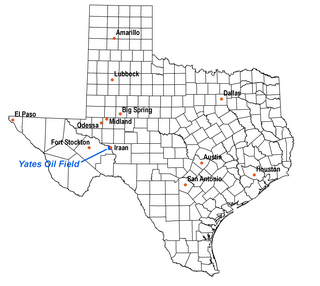
The Yates Oil Field is a giant oil field in the Permian Basin of west Texas. Primarily in extreme southeastern Pecos County, it also stretches under the Pecos River and partially into Crockett County. Iraan, on the Pecos River and directly adjacent to the field, is the nearest town. The field has produced more than one billion barrels of oil, making it one of the largest in the United States, and in 1998 it remains productive, though at a diminished rate. Since fracking has exploded in the Permian Basin, the Yates field has seen very heavy activity in the past three years. Estimated recoverable reserves are still approximately one billion barrels, which represents approximately 50% of the original oil in place (OOIP).

The Oklahoma City Oil Field is one of the world's giant petroleum fields and is located in Oklahoma City, Oklahoma in the United States of America. The field was opened just south of the city limits on December 4, 1928, and first entered Oklahoma City limits on May 27, 1930.
Linn Energy, Inc. was a company engaged in hydrocarbon exploration. It was incorporated in Delaware and headquartered in Houston. In 2018, the company split into Roan Resources and Riviera Resources.

The Wellington Formation is an Early Permian geologic formation in Kansas and Oklahoma. The formation's Hutchinson Salt Member is more recognized by the community than the formation itself, and the salt is still mined in central Kansas. The Wellington provides a rich record of Permian insects and its beddings provide evidence for reconstruction of tropical paleoclimates of the Icehouse Permian with the ability in cases to measure the passage of seasons. Tens of thousands of insect fossil recovered from the Wellington shales are kept in major collections at the Harvard Museum of Comparative Zoology and Yale Peabody Museum of Natural History.

The West Siberian petroleum basin is the largest hydrocarbon basin in the world covering an area of about 2.2 million km², and is also the largest oil and gas producing region in Russia.
Helium production in the United States totaled 73 million cubic meters in 2014. The US was the world's largest helium producer, providing 40 percent of world supply. In addition, the US federal government sold 30 million cubic meters from storage. Other major helium producers were Algeria and Qatar.

Slaughter Field is a 100,000+ acre conventional oil and gas field 40 miles west of Lubbock, TX in Cochran, Hockley, and Terry Counties. It was discovered in 1936 by a three-way venture between Honolulu Oil Company, Devonian Oil Company, and Cascade Petroleum Company. The area was originally two different fields: Duggan Field and Slaughter Field. When it was proven that both Duggan Field and Slaughter Field were producing from the same formation, they were combined under a single field regulation named Slaughter Field. In March 2015, it ranked 25th on the United States Energy Information's Top 100 U.S. Oil and Gas Fields.