Sedimentary rocks are types of rock that are formed by the accumulation or deposition of mineral or organic particles at Earth's surface, followed by cementation. Sedimentation is the collective name for processes that cause these particles to settle in place. The particles that form a sedimentary rock are called sediment, and may be composed of geological detritus (minerals) or biological detritus. The geological detritus originated from weathering and erosion of existing rocks, or from the solidification of molten lava blobs erupted by volcanoes. The geological detritus is transported to the place of deposition by water, wind, ice or mass movement, which are called agents of denudation. Biological detritus was formed by bodies and parts of dead aquatic organisms, as well as their fecal mass, suspended in water and slowly piling up on the floor of water bodies. Sedimentation may also occur as dissolved minerals precipitate from water solution.
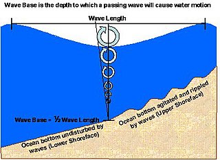
Lower Shoreface refers to the portion of the seafloor, and the sedimentary depositional environment, that lies below the everyday wave base.
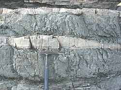
Tempestites are storm deposits that can be recognized throughout the geologic record. They are studied in the scientific disciplines of sedimentary geology and paleotempestology. The deposits derive their meaning from the word tempest, a violent storm. Tempestites are preserved within a multitude of sedimentary environments including delta systems, estuarian systems, coastal environments, deep sea environments, and fresh water lacustrine environments. Tempesites most often form in wave-dominated delta systems and preserve, within the sedimentary record, evidence of events and processes below fair weather wave base and above storm weather wave base. They are commonly characterized by hummocky cross-stratified beds that have an erosive base, and can form under combined flow regimes. This erosive base is often seen in the form of gutter casts.

The Roxbury Conglomerate, also informally known as Roxbury puddingstone, is a name for a rock formation that forms the bedrock underlying most of Roxbury, Massachusetts, now part of the city of Boston. The bedrock formation extends well beyond the limits of Roxbury, underlying part or all of Quincy, Canton, Milton, Dorchester, Dedham, Jamaica Plain, Brighton, Brookline, Newton, Needham, and Dover. It is named for exposures in Roxbury, Boston area.

The Aksu, is a river in Antalya Province, which rises in the mountains of Toros. The course of the Aksu is between the Düden to the west and of the Köprüçay to the east. It discharges into the Mediterranean near the city of Antalya. The river is about 145 km long and has a total catchment area of 3652 km². There are several lakes in its catchment area, including Lake Kovada and the reservoirs created by the Karacaören-1 and Karacaören-2 Dams.

In geology, cross-bedding, also known as cross-stratification, is layering within a stratum and at an angle to the main bedding plane. The sedimentary structures which result are roughly horizontal units composed of inclined layers. The original depositional layering is tilted, such tilting not being the result of post-depositional deformation. Cross-beds or "sets" are the groups of inclined layers, which are known as cross-strata.

In geology, ripple marks are sedimentary structures and indicate agitation by water or wind.

In geology, depositional environment or sedimentary environment describes the combination of physical, chemical, and biological processes associated with the deposition of a particular type of sediment and, therefore, the rock types that will be formed after lithification, if the sediment is preserved in the rock record. In most cases, the environments associated with particular rock types or associations of rock types can be matched to existing analogues. However, the further back in geological time sediments were deposited, the more likely that direct modern analogues are not available.
Sedimentary structures include all kinds of features in sediments and sedimentary rocks, formed at the time of deposition.

An antidune is a bedform found in fluvial and other channeled environments. Antidunes occur in supercritical flow, meaning that the Froude number is greater than 1.0 or the flow velocity exceeds the wave velocity; this is also known as upper flow regime. In antidunes, sediment is deposited on the upstream (stoss) side and eroded from the downstream (lee) side, opposite lower flow regime bedforms. As a result, antidunes migrate in an upstream direction, counter to the current flow. Antidunes are called in-phase bedforms, meaning that the water surface elevation mimics the bed elevation; this is due to the supercritical flow regime. Antidune bedforms evolve rapidly, growing in amplitude as they migrate upstream. The resultant wave at the water's surface also increases in amplitude. When that wave becomes unstable, breaks and washes downstream, much of the antidune bedform may be destroyed.
The Triassic Lockatong Formation is a mapped bedrock unit in Pennsylvania, New Jersey, and New York. It is named after the Lockatong Creek in Hunterdon County, New Jersey.

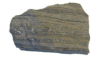
In geology, lamination is a small-scale sequence of fine layers that occurs in sedimentary rocks. Laminae are normally smaller and less pronounced than bedding. Lamination is often regarded as planar structures one centimetre or less in thickness, whereas bedding layers are greater than one centimetre. However, structures from several millimetres to many centimetres have been described as laminae. A single sedimentary rock can have both laminae and beds.
Vegetation-induced sedimentary structures (VISS) are primary sedimentary structures formed by the interaction of detrital sediment with in situ plants. VISS provide physical evidence of vegetation's fundamental role in mediating sediment accumulation and erosion in clastic depositional environments. VISS can be broken into seven types, five being hydrodynamic and two being decay-related. The simple hydrodynamic VISS are categorized by centroclinal cross strata, scratch semicircles and upturned beds. The complex hydrodynamic VISS are categorized by coalesced scour fills and scour-and-mound beds. The decay-related VISS are categorized by mudstone-filled hollows and downturned beds.

Soft-sediment deformation structures develop at deposition or shortly after, during the first stages of the sediment's consolidation. This is because the sediments need to be "liquid-like" or unsolidified for the deformation to occur. These formations have also been put into a category called water-escape structures by Lowe (1975). The most common places for soft-sediment deformations to materialize are in deep water basins with turbidity currents, rivers, deltas, and shallow-marine areas with storm impacted conditions. This is because these environments have high deposition rates, which allows the sediments to pack loosely.
Heterolithic bedding is a sedimentary structure made up of interbedded deposits of sand and mud. It is formed mainly in tidal flats but can also be formed in glacial environments. Examples from fluvial environments have been documented but are rare. Heterolithic bedding forms in response to alternations in sediment supply and tidal velocity. The fluctuations result in the interbedded layers of sand and mud. The rippled sand layer is formed during high tidal currents, while the mud is deposited during slack tide periods. The three main types of heterolithic bedding are flaser, wavy, and lenticular. Starved ripples and cross bedding with flasers can also be considered forms of heterolithic bedding. Differentiating of these various types of heterolithic bedding is based on the relative volume of mud and sand. This key determining factor is controlled by the timing, and duration of both the high tide, and slack tide depositional periods.
Iron-rich sedimentary rocks are sedimentary rocks which contain 15 wt.% or more iron. However, most sedimentary rocks contain iron in varying degrees. The majority of these rocks were deposited during specific geologic time periods: The Precambrian, the early Paleozoic, and the middle to late Mesozoic. Overall, they make up a very small portion of the total sedimentary record.

Porcupine Gorge is a gorge on Galah Creek in Porcupine, Shire of Flinders in North West Queensland, Australia. It is a protected area within the Porcupine Gorge National Park. Access to the gorge and national park is via the Kennedy Development Road.

The Huab Formation is an Early Permian geologic formation correlated with the Ecca Group and designated "Ecca" Group, because it does not belong to the Karoo, in the southwestern Kunene Region and northern Erongo Region of northwestern Namibia. The Huab Formation represents the oldest sedimentary unit of the Huab Basin, overlying the basement. The oil shales within the formation were deposited in a shallow lacustrine environment, and the formation marks the transition from terrestrial deposits under glacial climatic circumstances towards a warmer fluvial and marine deltaic environment.
The Gai-As Formation is an Early to Middle Permian geologic formation correlated with the Ecca Group and designated "Ecca" Group, because it does not belong to the Karoo, in the southwestern Kunene Region and northern Erongo Region of northwestern Namibia. The Gai-As Formation represents the second-oldest sedimentary unit of the Huab Basin, overlying the Huab Formation. The formation was deposited in a fluvial to lacustrine setting.

Glaciofluvial deposits or Glacio-fluvial sediments consist of boulders, gravel, sand, silt and clay from ice sheets or glaciers. They are transported, sorted and deposited by streams of water. The deposits are formed beside, below or downstream from the ice. They include kames, kame terraces and eskers formed in ice contact and outwash fans and outwash plains below the ice margin. Typically the outwash sediment is carried by fast and turbulent fluvio-glacial meltwater streams, but occasionally it is carried by catastrophic outburst floods. Larger elements such as boulders and gravel are deposited nearer to the ice margin, while finer elements are carried farther, sometimes into lakes or the ocean. The sediments are sorted by fluvial processes. They differ from glacial till, which is moved and deposited by the ice of the glacier, and is unsorted.