Hurricane Chantal (1989)

Last updated

Map key
  Tropical depression (≤38 mph, ≤62 km/h)
  Tropical storm (39–73 mph, 63–118 km/h)
  Category 1 (74–95 mph, 119–153 km/h)
  Category 2 (96–110 mph, 154–177 km/h)
  Category 3 (111–129 mph, 178–208 km/h)
  Category 4 (130–156 mph, 209–251 km/h)
  Category 5 (≥157 mph, ≥252 km/h)
  Unknown
Storm type
Disc Plain black.svg Tropical cyclone
Solid black.svg Subtropical cyclone
ArrowUp.svg Extratropical cyclone, remnant low, tropical disturbance, or monsoon depression

The origins of Hurricane Chantal can be tracked back to a tropical disturbance within the Intertropical Convergence Zone near Trinidad and Tobago on July 24. The system crossed westward over the Caribbean Sea, and there were no signs of organization until July 27 near the coast of Honduras. Despite the predictions for slow development from the tropical weather outlooks, it was possible that the system developed a surface low center near Belize City, Belize late on July 28. After the system moved inland over the Yucatán Peninsula, it became disorganized, although the National Hurricane Center indicated in the tropical weather outlook that once it moved into the Gulf of Mexico there was potential for development. Although the outflow of the system had appeared impressive on satellite images, the potential for development seemed uncertain, mostly due to the close proximity to land. The storm quickly became better organized based on satellite data and ship reports. [1]

Tropical Storm Chantal on July 31 Chantal jul 31 1989 1925Z.jpg
Tropical Storm Chantal on July 31

Almost immediately after emerging into the Gulf of Mexico on July 30, the cloud pattern of system quickly became better organized. Later after emerging into the Gulf of Mexico, ships and satellite images confirmed that Tropical Depression Four had formed offshore of the north coast of the Yucatán Peninsula; although it was likely that the depression formed 80 miles (130 km) north of the Yucatán Peninsula several hours earlier than confirmed. [1] [2] The following morning after development occurred, the depression had intensified into a tropical storm 575 miles (925 km) southeast of Texas; the National Hurricane Center assigned it to the name Chantal. [1] Although it became a tropical storm early that morning, the system was not upgraded to a tropical storm until a reconnaissance flight confirmed tropical storm force winds about six hours later, when sustained winds were already 50 mph (80 km/h). Tropical Storm Chantal rapidly strengthened thereafter, with weather satellites indicating t–numbers increasing from 2.5 to 3.5 within twelve hours using the Dvorak technique. Chantal continued to intensify, and headed northwestward at 11 mph (18 km/h) due to weak ridging over Florida. [3]

Later on July 31, satellite imagery revealed better organization, and another reconnaissance flight found winds at 91 mph (146 km/h) while flying at 1,500 feet (460 m). Based on these observations, it was estimated that Chantal had intensified into a hurricane early on August 1. Hurricane Chantal continued to intensify, slightly, and attained its peak intensity on August 1 at 1000 UTC, reaching maximum sustained winds of 80 mph (130 km/h) and a minimum barometric pressure of 986  mbar (29.1  inHg ). Only three hours thereafter, Hurricane Chantal made landfall near High Island, Texas with winds still at 80 mph (130 km/h). Chantal rapidly weakened to a tropical storm at 1800 UTC on August 2, just five hours after landfall, and quickly degenerated to a tropical depression early on August 2. Tropical Depression continued its course and eventually dissipated over western Oklahoma on August 3. The remnants of Chantal then moved northward over the Great Plains and was tracked northward over New York, eventually reaching New England and Newfoundland just before Hurricane Dean approached. [3] [4]

Preparations

At 0000 UTC on July 31, a tropical storm watch indicating tropical storm force winds were possible within 48 hours was issued from Port O'Connor, Texas to the mouth of the Mississippi River. Three hours thereafter, a hurricane warning signifying that hurricane-force winds were likely in 24 hours or less was issued from Freeport, Texas to Morgan City, Louisiana. A tropical storm warning was simultaneously put into effect from Port O'Connor, Texas to Mobile, Alabama, significantly overlapping the existing hurricane warning. The tropical storm warning was discontinued at 1000 UTC on August 1. Six hours later, the hurricane warning issued at 0300 UTC on July 31 was downgraded to a tropical storm warning, before the portion from Port Arthur, Texas to Morgan City, Louisiana was canceled. The remaining portion from Freeport to Port O'Connor, Texas was discontinued at 0100 UTC on August 2. [5]

In addition to the tropical cyclone watches and warnings, several other actions were taken as Chantal approached. More than 600 oil workers were moved inland, [6] though a man drowned while attempting to evacuate a rig south of New Orleans, Louisiana. [7] Mayor of Port Arthur Malcolm Grant asked 800 residents to evacuate Sabine Pass, due to potential coastal flooding isolating the area. Shelters were opened at various schools in Port Arthur and Beaumont. In nearby Orange, crews at emergency centers distributed sand bags. About 8,500 residents of Cameron Parish, Louisiana evacuated, with at least 67 people taking shelter at a school in Lake Charles. An additional 2,500 people fled Grand Isle, as the threat of the only road to the island flooding loomed. [6]

Impact

Texas bore the brunt of the storm, where strong winds and heavy rainfall damaged about 3,000 homes and knocked downed numerous trees and signs. [4] Chantal also spawned two tornadoes, one in Crystal Beach, Texas and the other in Acadia Parish, Louisiana; both of which caused minor damage. [4] Additionally, 13 fatalities occurred, all of them due to drowning; 11 deaths occurred offshore in the Gulf of Mexico, while the remaining two were reported in east-central Texas. [7] Overall, the storm resulted in at least $100 million (1989 USD) in damage. [4]

Mexico

Prior to becoming a tropical cyclone, the precursor tropical disturbance dropped rainfall on the Yucatán Peninsula of Mexico. The precipitation put out fires burning in the region, which had destroyed up to 370,000 acres (150,000  ha ) of jungle in the two months prior to the tropical disturbance, according to the Agriculture Department of Mexico. [8]

Texas

Rainfall totals in the United States associated with Hurricane Chantal Chantal 1989 rainfall.png
Rainfall totals in the United States associated with Hurricane Chantal

Galveston County

The worst effects from the storm occurred in Galveston County. Waves of 7 feet (2.1 m) in height were reported on High Island during Chantal, while Kemah measured tides of 3.8 feet (1.2 m), and the Galveston Flagship pier reported 3.5 feet (1.1 m) seas. [2] The high tides eroded more than 1 mile (1.6 km) of Texas State Highway 87, while at least another 15 miles (24 km) of that highway was covered in sand and debris. As a result, the highway was expected to be closed for at least five weeks, [9] though in October 1989, storm surge from Hurricane Jerry caused more erosion, and no repairs have been made since. [10] In the northern portions of Galveston County, rainfall was generally at least 12 inches (300 mm), [9] which a peak of 20 inches (510 mm) in Friendswood. [11] Numerous streets in League City, Dickinson, and Friendswood were flooded for more than 24 hours. At least 100 homes in Friendswood were flooded, while water entered 70% of houses in Dickinson. Severe street flooding and ponding occurred in Galveston, especially in the low-lying areas; some homes and businesses were damaged, as a result. Overall, 500 homes in the county were flooded. [9]

Strong winds also effected the county, with the highest recorded sustained wind speed being 70 mph (110 km/h) in Galveston; the highest gust of 83 mph (134 km/h) was reported at the same location. [2] At the National Weather Service Office in Downtown Galveston, sustained winds were 53 mph (85 km/h) and gusts reached 69 mph (111 km/h). Although winds were strong, associated losses was confined to roof damage at beach homes in Gilchrist and High Island. In addition to strong winds, heavy rainfall, and high tides, the storm also produced one tornado in the county. Rated as an F0 on the Fujita scale, the tornado was spawned in Crystal Beach, where it destroyed a boat shed; elsewhere, no damage occurred from this twister. [9]

Harris County

Rainfall produced by Chantal in the city of Houston alone varied extensively, with 7.14 inches (181 mm) at William P. Hobby Airport after twenty-four hours, and only 1.21 inches (31 mm) at George Bush Intercontinental Airport (then known as Houston Intercontinental Airport) in the same time lapse. In the southern portions of Harris County, rainfall totaled ranged from 8 to 12 inches (200 to 300 mm). Significant amounts of precipitation resulted in flooding, which in turn, caused several hundred emergency crew rescues and damage to at least 500 homes. [9] Strong winds also caused significant effects in the county. In La Porte, where winds gusted to 70 mph (110 km/h), 40 trees were toppled at a golf course, while a plane was flipped over at the La Porte Municipal Airport. The roof of a mobile home was torn off and a fence and a portable building was destroyed in Highlands. Winds damaged a red cross shelter in Pasadena and blew out several windows at a hospital in Baytown. Throughout the county, high winds destroyed 2 mobile homes and damaged 49 apartments and 24 businesses. [9]

Elsewhere in Texas

Heavy rainfall affected Brazoria County, where precipitation amounts up to 12 inches (300 mm) were reported; this caused significant flooding, especially in Pearland and Manvel. During the height of the storm, the entire town of Manvel was inundated with water, causing flood damage to at least 100 homes. Additionally, high winds in combination with floods damaged about 500 homes throughout the county. In Chambers County high winds caused two injuries and tore roofing material off of homes and mobile homes; about 100 homes were effected in the area. 6 inches (150 mm) of rain fell in the southern portions of the county, causing minor flooding. Between 8 and 12 inches (200 and 300 mm) of precipitation was recorded in eastern Fort Bend County. In the city of Fresno, at least 60 homes were flooded and several families were evacuated. After 9.7 inches (250 mm) of rain fell in Richmond, local flooding occurred. Several mobile homes in the county also suffered wind damage. [9]

In Brazos County, heavy rainfall caused street flooding in College Station. [9] Precipitation in Collin County reached as high as 16 inches (410 mm) in Clear Lake, though no flood damage was reported. [4] Additionally, two fatalities occurred when two teenage boys were riding a rubber raft, swept into a drainpipe, and subsequently drowned. [9] The highest sustained wind speed recorded in Jefferson County was 54 mph (87 km/h) at Sea Rim State Park, while the strongest gust was 49 mph (79 km/h) at the Jack Brooks Regional Airport. Winds downed trees and limbs, while also causing minor roof damage. Tides at Sabine Pass were about 3.9 feet (1.2 m) about mean sea level; some beach erosion was reported near that location. In Liberty County, winds felled tree limbs, which damaged vehicles and portable buildings. [9]

Elsewhere

One fatality was reported during an oil rig evacuation in the Gulf of Mexico. Ten other people perished when a lifeboat capsized south of Morgan City, Louisiana. Four others on the boat were rescued by the United States Coast Guard. [7] In Louisiana, high tides were only reported at one location, with seas reaching about 4.2 feet (1.3 m) in Cameron. Winds in the state were also light, with the highest sustained wind speed being 29 mph (47 km/h) along the Lake Pontchartrain Causeway, while the strongest gust was approximately 42 mph (68 km/h) in New Orleans. [12] Rainfall was mostly minimal throughout the state and mainly less than 3 inches (76 mm), while the highest total recorded as 3.84 inches (98 mm) in Amite City. [13] A tornado touched down in Acadia Parish, where it downed trees and removed a mobile home from its foundation. The only known impact in Mississippi was tides of 2.6 feet (0.79 m) above mean sea level. [4]

Further north in the Midwestern United States, impact was generally minor. Chantal and its remnants dropped mostly light rainfall in the states of Oklahoma, Missouri, Kansas, Iowa, Wisconsin, Illinois, Indiana, and Michigan. Only two of those states Illinois and Michigan recorded more than 4 inches (100 mm) of precipitation. [13] In Illinois, rainfall in Chicago flooded numerous streets and basements; Lake Shore Drive and Edens Expressway were briefly closed, as a result. Outside Chicago, minor flooding also occurred along a few creeks and low-lying areas. [9] The rainfall rate of 2 inches (51 mm) per hour in Grand Rapids, Michigan caused the release of about 40 million gallons of untreated sewage into the Grand River. [14] Despite crossing through Ontario and New York, it is unknown if any impact occurred in those two locations. [7] [9] In Vermont, the remnants of Chantal dropped rainfall in excess of 6 inches (150 mm) along the Caledonia, Orange, and Washington county lines. Bridges were knocked down, cars and homes were swept away, and crops were destroyed in the resultant flash floods. [9]

See also

Related Research Articles

<span class="mw-page-title-main">Hurricane Alicia</span> Category 3 Atlantic hurricane in 1983

Hurricane Alicia was a small but powerful tropical cyclone that caused significant destruction in the Greater Houston area of Southeast Texas in August 1983. Although Alicia was a relatively small hurricane, its track over the rapidly growing metropolitan area contributed to its $3 billion damage toll, making it the costliest Atlantic hurricane at the time. Alicia spawned from a disturbance that originated from the tail-end of a cold front over the northern Gulf of Mexico in mid-August 1983. The cyclone was named on August 14 when it became a tropical storm, and the combination of weak steering currents and a conducive environment allowed Alicia to quickly intensify as it drifted slowly westward. On August 17, Alicia became a hurricane and continued to strengthen, topping out as a Category 3 major hurricane as it made landfall on the southwestern end of Galveston Island. Alicia's eye passed just west of Downtown Houston as the system accelerated northwestwards across East Texas; Alicia eventually weakened into a remnant area of low pressure over Oklahoma on August 20 before they were last noted on August 21 over eastern Nebraska.

<span class="mw-page-title-main">Tropical Storm Allison</span> Atlantic tropical storm in 2001

Tropical Storm Allison was a tropical storm that devastated southeast Texas in June of the 2001 Atlantic hurricane season. An arguable example of the "brown ocean effect", Allison lasted unusually long for a June storm, remaining tropical or subtropical for 16 days, most of which was when the storm was over land dumping torrential rainfall. The storm developed from a tropical wave in the northern Gulf of Mexico on June 4, 2001, and struck the upper Texas coast shortly thereafter. It drifted northward through the state, turned back to the south, and re-entered the Gulf of Mexico. The storm continued to the east-northeast, made landfall on Louisiana, then moved across the southeast United States and Mid-Atlantic. Allison was the first storm since Tropical Storm Frances in 1998 to strike the northern Texas coastline.

<span class="mw-page-title-main">1989 Atlantic hurricane season</span> Hurricane season in the Atlantic Ocean

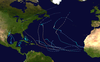
The 1989 Atlantic hurricane season was an average season with 11 named storms. The season officially began on June 1, and ended on November 30. The first storm, Tropical Depression One, developed on June 15, and dissipated two days later without any effects on land. Later that month, Tropical Storm Allison caused severe flooding, especially in Texas and Louisiana. Tropical Storm Barry, Tropical Depressions Six, Nine, and Thirteen, and Hurricanes Erin and Felix caused negligible impact. Hurricane Gabrielle and Tropical Storm Iris caused light effects on land, with the former resulting in nine fatalities from rip currents offshore the East Coast of the United States and Atlantic Canada, while the latter produced minor flooding in the United States Virgin Islands.

<span class="mw-page-title-main">Hurricane Carla</span> Category 4 Atlantic hurricane in 1961

Hurricane Carla was the most intense tropical cyclone landfall in Texas in the 20th century. The third named storm of the 1961 Atlantic hurricane season, Carla developed from an area of squally weather in the southwestern Caribbean Sea on September 3. Initially a tropical depression, it strengthened slowly while heading northwestward, and by September 5, the system was upgraded to Tropical Storm Carla. About 24 hours later, Carla was upgraded to a hurricane. Shortly thereafter, the storm curved northward while approaching the Yucatán Channel. Late on September 7, Carla entered the Gulf of Mexico while passing just northeast of the Yucatán Peninsula. By early on the following day, the storm became a major hurricane after reaching Category 3 intensity. Resuming its northwestward course, Carla continued intensification and on September 11, became what would today be classified as a Category 4 hurricane. Later that day, Carla weakened slightly but was still a large and intense hurricane when the storm made landfall near Port O'Connor, Texas. It weakened quickly inland and was reduced to a tropical storm on September 12. Heading generally northward, Carla transitioned into an extratropical cyclone on September 13, while centered over southern Oklahoma. Rapidly moving northeastward, Carla's remnants reached the Labrador Sea, Canada and dissipated on September 17, 1961.

<span class="mw-page-title-main">Tropical Storm Allison (1989)</span> Atlantic tropical storm in 1989

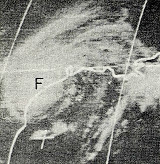
Tropical Storm Allison was a tropical cyclone that produced severe flooding in the southern United States. The second tropical cyclone and the first named storm of the 1989 Atlantic hurricane season, Allison formed on June 24 in the northwestern Gulf of Mexico. Development of Allison was a result of the interaction of a tropical wave and the remnants of Pacific hurricane Hurricane Cosme. It moved south and became a tropical storm on June 26. By June 27, Allison made landfall near Freeport, Texas. Allison quickly weakened to a tropical depression later that day, and transitioned into an extratropical cyclone on the following day. However, the storm's remnants persisted for another 10 days and meandered across the area, triggering flooding across the region, before dissipating on July 7.

<span class="mw-page-title-main">Tropical Storm Claudette (1979)</span> Atlantic tropical storm in 1979

Tropical Storm Claudette was a 1979 tropical cyclone which was the third-wettest tropical cyclone on record in the contiguous United States. The storm caused significant flooding in eastern Texas and western Louisiana in July 1979. The eighth tropical cyclone and third named storm of the 1979 Atlantic hurricane season, Claudette developed from a tropical wave located east of the Windward Islands on July 16. It gradually strengthened and was upgraded to a tropical storm on July 17 and crossed the northern Leeward Islands later that day. As it neared landfall in Puerto Rico early on July 18, upper-level winds weakened it back to a tropical depression. Claudette remained disorganized and the National Hurricane Center operationally reported that it degenerated back into a tropical wave after crossing Puerto Rico. Late on July 18, the depression struck Dominican Republic, emerged into the Caribbean Sea on the following day. Claudette struck western Cuba on July 21, shortly before reaching the Gulf of Mexico and "regenerating" into a tropical cyclone. By July 23, Claudette regained tropical storm intensity and turned northward toward the Gulf Coast of the United States. The storm made landfall near the Texas-Louisiana border late on July 23 as a moderately strong tropical storm. It weakened slowly and drifted over land, lasting until dissipation in West Virginia on July 29.

<span class="mw-page-title-main">Hurricane Jerry (1989)</span> Category 1 Atlantic Hurricane in 1989

Hurricane Jerry caused minor damage in Texas and flash flooding in Kentucky and Virginia in October 1989. The fourteenth tropical cyclone, tenth named storm, and seventh hurricane of the season, Jerry developed from a tropical wave in the Bay of Campeche on October 12. Initially a tropical depression, the system moved north-northwestward across the Gulf of Mexico and strengthened into Tropical Storm Jerry early on the following day. Jerry continuously deepened until October 14 and then maintained intensity while curving northeastward and briefly decelerating. Later that day, the storm re-curved north-northwestward. Jerry began to intensify on October 15 and soon became a Category 1 hurricane on the Saffir–Simpson hurricane wind scale. Early on October 16, Jerry made landfall on Galveston Island, Texas with winds of 85 miles per hour (137 km/h). Less than six hours later, Jerry weakened to a tropical storm and then a tropical depression shortly thereafter. Late on October 16, Jerry was absorbed by a frontal system while situated over southwestern Arkansas.

<span class="mw-page-title-main">Tropical Storm Grace (2003)</span> Atlantic tropical storm in 2003

Tropical Storm Grace was a weak tropical storm that struck Texas in the 2003 Atlantic hurricane season. The eleventh tropical depression and the seventh tropical storm of the season, Grace was also the weakest storm of the season. On August 30 the storm developed from a long-track tropical wave in the western Gulf of Mexico. Grace remained disorganized throughout its lifetime due to an upper-level low to its west. The weak storm moved northwestward and made landfall on southeastern Texas. Grace quickly weakened over land, and dissipated on September 2 as it merged into a cold front.

<span class="mw-page-title-main">Hurricane Fern</span> Category 1 Atlantic hurricane in 1971

Hurricane Fern was the sixth named storm and fourth hurricane of the 1971 Atlantic hurricane season. It formed from a tropical wave which interacted with a large trough of low pressure to form Fern, as well as Hurricane Ginger, Tropical Storm Heidi, and a system later designated as Tropical Depression Sixteen, which moved into South Carolina. Fern crossed southeastern Louisiana as a tropical depression on September 4 before swinging back out over the Gulf of Mexico. Fern reached hurricane status on September 8, reaching a peak intensity of 90 mph (140 km/h) before making landfall near Freeport, Texas, two days later.

<span class="mw-page-title-main">1987 Gulf Coast tropical storm</span> Atlantic tropical storm in 1987

The 1987 Gulf Coast tropical storm caused flooding along the Gulf Coast of the United States. The second tropical cyclone and first tropical storm of the 1987 Atlantic hurricane season, it originated from a tropical wave in the Gulf of Mexico, southeast of Texas, on August 9. Initially a tropical depression, the cyclone moved north-northwestward and slightly intensified into a tropical storm later that day. By August 10, it made landfall between Galveston and Beaumont. The system weakened after moving inland and turned towards the east and later southeast. Briefly reemerging over the Gulf on August 15, the depression moved onshore a second time in Florida, before dissipating over eastern Georgia on August 17.

<span class="mw-page-title-main">Tropical Storm Dean (1995)</span> Atlantic tropical storm in 1995

Tropical Storm Dean was a short-lived storm that formed in late July 1995 and lasted into early August. It was the fourth named storm of the 1995 Atlantic hurricane season. It spent most of its life as a tropical depression, and briefly gained tropical storm status before its landfall on the Texas coast on July 30. After landfall, it dissipated over central Texas on August 2. The impacts from Dean were minimal, mainly due to heavy rain in Oklahoma and Texas that caused localized coastal and inland flooding. Two F0 Tornadoes touched down in Texas as a result of Dean's landfall. Also, Twenty families had to be evacuated in Chambers County, due to flooding in the area. One fatality was recorded as a result of flooding in Oklahoma. Several highways were flooded out in Oklahoma, which impeded travel in the state. In addition approximately $500,000 worth of damage was recorded in the aftermath of Dean.

<span class="mw-page-title-main">Tropical Storm Danielle (1980)</span> Atlantic tropical storm in 1980

Tropical Storm Danielle caused considerable flooding in the state of Texas during September 1980. The eighth tropical cyclone and fourth named storm of the 1980 Atlantic hurricane season, Danielle developed from a tropical wave that emerged into the Atlantic Ocean from the west coast of Africa on August 22. Three days later, the tropical wave developed into a tropical depression. Four days later, the depression degenerated into a tropical wave. After tracking westward and entering the Gulf of Mexico, the system gradually developed, and became a tropical depression on September 4. The depression gradually strengthened and became Tropical Storm Danielle only hours before landfall in eastern Texas on September 5. Danielle steadily weakened inland and dissipated two days later.

<span class="mw-page-title-main">Tropical Storm Edouard (2008)</span> Atlantic tropical storm in 2008

Tropical Storm Edouard brought coastal and minor inland flooding to Louisiana and Texas in August 2008. The fifth tropical cyclone and fifth named storm of the hurricane season, Edouard developed from a trough in the northern Gulf of Mexico on August 3. After developing into a tropical depression, it gradually strengthened and was upgraded to Tropical Storm Edouard on August 4. However, northerly wind shear initially halted any further significant intensification and also caused the storm to struggle to maintain deep convection over the center. Edouard eventually intensified further and peaked as a strong tropical storm with winds of 65 mph (100 km/h) on August 5. Shortly thereafter, the storm made landfall near Gilchrist, Texas later that day. Edouard quickly weakened and was downgraded to tropical depression by early on August 6, six hours before degenerated into a remnant low pressure area.

<span class="mw-page-title-main">Hurricane Rosa (1994)</span> Category 2 Pacific hurricane in 1994

Hurricane Rosa was the only Pacific hurricane to make landfall during the above-average 1994 Pacific hurricane season. It killed at least 4 people in Mexico. Moisture from the hurricane was a factor in widespread flooding in the U.S. state of Texas that killed 22 people and caused hundreds of millions of dollars in damage in October 1994. The pre-Rosa tropical depression formed on October 8 before degenerating the next day. It reformed on October 10 and steadily strengthened as it approached Mexico. Ultimately peaking as a Category 2 hurricane on the Saffir-Simpson Hurricane Scale right before landfall, Rosa was the final hurricane, nineteenth tropical storm, and second-last tropical cyclone of the 1994 Pacific hurricane season.

<span class="mw-page-title-main">Hurricane Bonnie (1986)</span> Category 1 Atlantic hurricane in 1986

Hurricane Bonnie caused moderate damage along the Gulf Coast of the United States in late June 1986. The second named storm and first hurricane of the 1986 Atlantic hurricane season, Bonnie developed out of an area of low pressure over the central Gulf of Mexico on June 23. The system gradually intensified and was declared Tropical Storm Bonnie the next day as it moved generally towards the west-northwest. On June 25, Bonnie was upgraded to a hurricane. Bonnie strengthened further and on the following day, the storm attained its peak intensity with maximum sustained winds of 85 mph (137 km/h). Shortly thereafter, Bonnie made landfall near High Island, Texas. Following landfall, Bonnie quickly weakened below tropical storm status and dissipated over Missouri on June 28.

<span class="mw-page-title-main">Hurricane Debra (1959)</span> Category 1 Atlantic hurricane in 1959

Hurricane Debra was a destructive tropical cyclone that developed during the 1959 Atlantic hurricane season. The fifth tropical storm and third hurricane of the season, Debra originated from the interaction of a cold-core low and a tropical wave on July 15. The system was designated a tropical depression on July 23 when it was south of Louisiana and meandered westward while it swiftly intensified into a tropical storm along the Gulf Coast of the United States. A turn towards the northwest became evident as it attained Category 1 hurricane status on the Saffir–Simpson Hurricane Scale the following day while it organized into a developed storm. As the hurricane curved northward at a slow forward speed, strength was maintained as it approached the coast of Texas as a minimal hurricane. It came ashore during the evening of July 24 local time between Freeport and Galveston, Texas. It rapidly weakened into a tropical storm and later a depression as it moved inland, and dissipated on July 28 while it turned northwestward. The remnant moisture later sparked upper-level thunderstorms in late July and early August.

<span class="mw-page-title-main">Hurricane Andrew</span> Category 5 Atlantic hurricane in 1992

Hurricane Andrew was a very powerful and destructive Category 5 Atlantic hurricane that struck the Bahamas, Florida, and Louisiana in August 1992. It is the most destructive hurricane to ever hit Florida in terms of structures damaged or destroyed, and remained the costliest in financial terms until Hurricane Irma surpassed it 25 years later. Andrew was also the strongest landfalling hurricane in the United States in decades and the costliest hurricane to strike anywhere in the country, until it was surpassed by Katrina in 2005. In addition, Andrew is one of only four tropical cyclones to make landfall in the continental United States as a Category 5, alongside the 1935 Labor Day hurricane, 1969's Camille, and 2018's Michael. While the storm also caused major damage in the Bahamas and Louisiana, the greatest impact was felt in South Florida, where the storm made landfall as a Category 5 hurricane, with 1-minute sustained wind speeds as high as 165 mph (266 km/h) and a gust as high as 174 mph (280 km/h). Passing directly through the cities of Cutler Bay and Homestead in Dade County, the hurricane stripped many homes of all but their concrete foundations and caused catastrophic damage. In total, Andrew destroyed more than 63,500 houses, damaged more than 124,000 others, caused $27.3 billion in damage, and left 65 people dead.

References

  1. 1 2 3 Harold P. Gerrish. Preliminary Report Hurricane Chantal: 30 July to 3 August 1989 (GIF) (Report). Hurricane Chantal, Hurricane Wallet Digital Archives. Miami, Florida: National Hurricane Center. Retrieved January 9, 2013.
  2. 1 2 3 Robert A. Case and B. Max Mayfield (May 1990). Atlantic Hurricane Season of 1989 (PDF) (Report). Monthly Weather Reviews. Miami, Florida: Atlantic Oceanographic and Meteorological Laboratory . Retrieved January 9, 2013.
  3. 1 2 Harold P. Gerrish. Preliminary Report Hurricane Chantal: 30 July to 3 August 1989 (GIF) (Report). Hurricane Chantal, Hurricane Wallet Digital Archives. Miami, Florida: National Hurricane Center. p. 2. Retrieved January 9, 2013.
  4. 1 2 3 4 5 6 Harold P. Gerrish. Preliminary Report Hurricane Chantal: 30 July to 3 August 1989 (GIF) (Report). Hurricane Chantal, Hurricane Wallet Digital Archives. Miami, Florida: National Hurricane Center. p. 3. Retrieved January 9, 2013.
  5. Harold P. Gerrish (1989). Table 3. Warnings issued for Hurricane Chantal, July and August 1989 (GIF) (Report). Hurricane Chantal, Hurricane Wallet Digital Archives. Miami, Florida: National Hurricane Center. p. 13. Retrieved January 9, 2013.
  6. 1 2 "Thousands Flee As Hurricane Chantal hits Texas". Reading Eagle . High Island, Texas. Associated Press. August 1, 1989. p. 2. Retrieved January 9, 2013.
  7. 1 2 3 4 Harold P. Gerrish (November 22, 1989). "Preliminary Report Hurricane Chantal: 30 July to 3 August 1989" (GIF). Hurricane Chantal, Hurricane Wallet Digital Archives. Miami, Florida: National Hurricane Center. p. 4. Retrieved January 9, 2013.
  8. Jeff Awalt (August 2, 1989). "Chantal does little damage in Texas". Star-Banner . High Island, Texas. Associated Press. p. 27. Retrieved January 9, 2013.
  9. 1 2 3 4 5 6 7 8 9 10 11 12 13 Jay Hollifield and S. C. Lackey. Storm Data - August 1989 (PDF) (Report). Asheville, North Carolina: National Climatic Data Center. pp. 30, 45–47, and 49. Retrieved January 9, 2013.
  10. B. Max Mayfield (November 21, 1989). Hurricane Jerry Preliminary Report (GIF) (Report). Hurricane Jerry, Hurricane Wallet Digital Archives. Miami, Florida: National Hurricane Center. p. 3. Retrieved January 9, 2013.
  11. David M. Roth (May 14, 2007). Hurricane Chantal - July 31August 4, 1989 (Report). Hydrometeorological Prediction Center's Rainfall Archive. College Park, Maryland: Hydrometeorological Prediction Center . Retrieved January 9, 2013.
  12. Harold P. Gerrish (November 22, 1989). "Table 2. Hurricane Chantal surface observations, 1 August 1989" (GIF). Hurricane Chantal, Hurricane Wallet Digital Archives. Miami, Florida: National Hurricane Center. p. 7. Retrieved January 9, 2013.
  13. 1 2 Tropical Cyclone Rainfall for the Gulf Coast (Report). Hydrometeorological Prediction Center's Rainfall Archive. College Park, Maryland: Hydrometeorological Prediction Center. 2012. Retrieved January 9, 2013.
  14. "Storms Cut Power in Chicago, Release Sewage in Michigan". Los Angeles Times . Los Angeles, California. United Press International. August 5, 1989. Retrieved January 9, 2013.
Hurricane Chantal
Chantal 1989-07-31 2200Z.png
Hurricane Chantal near peak intensity south of the Texas coast on July 31