
Munising is a city on the southern shore of Lake Superior on the Upper Peninsula of the U.S. state of Michigan. The population was 2,355 at the 2010 census. It is the county seat of Alger County. The city is adjacent to the northwest corner of Munising Township, but is administratively autonomous.

Hiawatha National Forest is a 894,836-acre (362,127 ha) National Forest in the Upper Peninsula of the state of Michigan in the United States. Commercial logging is conducted in some areas. The United States Forest Service administers this National Forest; it is physically divided into two subunits, commonly called the Eastside 46°14′N84°50′W and Westside 46°08′N86°40′W. In descending order of land area it lies in parts of Chippewa, Delta, Mackinac, Alger, Schoolcraft, and Marquette counties. Chippewa and Mackinac counties are in the Eastside, whereas the rest are in the Westside. The smaller Eastside contains about 44% of the forest's area, whereas the larger Westside has about 56%. Forest headquarters are located in Escanaba, Michigan. Eastside ranger district offices are located in Sault Ste. Marie and St. Ignace, while Westside offices are in Manistique, Munising, and Rapid River.

Sleeping Bear Dunes National Lakeshore is a United States National Lakeshore located along the northwest coast of the Lower Peninsula of Michigan in Leelanau and Benzie counties near Empire, Michigan. The park covers a 35-mile-long (56 km) stretch of Lake Michigan's eastern coastline, as well as North and South Manitou islands. This Northern Michigan park was established primarily because of its outstanding natural features, including forests, beaches, dune formations, and ancient glacial phenomena. The lakeshore also contains many cultural features including the 1871 South Manitou Island Lighthouse, three former stations of the Coast Guard and an extensive rural historic farm district. In 2011, the area won the title of "The Most Beautiful Place in America" from Good Morning America. In 2014, a section of the park was named the Sleeping Bear Dunes Wilderness by the United States Congress.

Pictured Rocks National Lakeshore is a U.S. National Lakeshore on the shore of Lake Superior in the Upper Peninsula of Michigan, United States. It extends for 42 miles (67 km) along the shore and covers 73,236 acres. The park has extensive views of the hilly shoreline between Munising and Grand Marais in Alger County, Michigan, with picturesque rock formations, waterfalls, and sand dunes.

Obed River is a stream draining a part of the Cumberland Plateau in Tennessee. It, and particularly its tributaries, are important streams for whitewater enthusiasts.
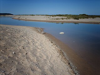
The Platte River is located in the northern part of the Lower Peninsula of Michigan. Its mouth is located in Sleeping Bear Dunes National Lakeshore and much of the rest is in the Pere Marquette State Forest.
Carp River is a 40.2-mile-long (64.7 km) river in Chippewa and Mackinac counties in the U.S. state of Michigan. 21.7 miles (34.9 km) of the river were added to the National Wild and Scenic Rivers System in 1992.
The Black River is a 41.1-mile-long (66.1 km) river on the Upper Peninsula of the U.S. state of Michigan, flowing mostly in Gogebic County into Lake Superior at 46°40′03″N90°02′57″W. Its source at 46°18′54″N90°01′15″W is a boreal wetland on the border with Iron County, Wisconsin. The northern section of the river, 14 miles (23 km) within the boundaries of the Ottawa National Forest, was designated a National Wild and Scenic River in 1992.
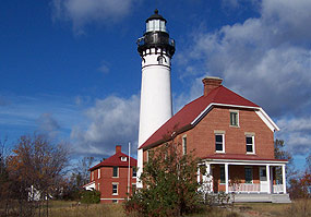
Au Sable Light is an active lighthouse in the Pictured Rocks National Lakeshore west of Grand Marais, Michigan off H-58. Until 1910, this aid to navigation was called "Big Sable Light".
The Crystal River is a 6.3-mile-long (10.1 km) stream located in the southwest section of Leelanau County in northern Michigan's Lower Peninsula, flowing from Glen Lake through sections of the Sleeping Bear Dunes National Lakeshore into Lake Michigan just north of the small town of Glen Arbor. Although the straight-line distance between Glen Lake and Lake Michigan is only 1.2 miles (1.9 km), the river meanders through swamp lands for more than 5 times that distance.
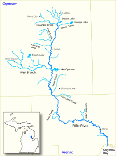
Rifle River is a 60.3-mile-long (97.0 km) river in the U.S. state of Michigan. It rises in northeastern Ogemaw County and flows through Arenac County to enter Saginaw Bay of Lake Huron. Once a logging river during the Michigan forestry boom at the turn of the 20th century, the river is now primarily used for recreation, and is a state-designated natural river. It is a popular river for canoeing, with no portages or dams and an average depth of 18 inches, to 5 feet in downtown Omer. It is also known for having one of the best White Sucker runs in the state of Michigan, in the spring.
The Bass River is a 3.6-mile-long (5.8 km) stream in Ottawa County, Michigan. It flows into the Grand River and thence into Lake Michigan. At the Bass River's Grand River mouth is the Bass River State Recreation Area.
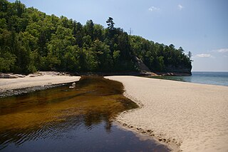
The Miners River is a river on the Upper Peninsula of Michigan in the United States. It is the largest river in the Pictured Rocks National Lakeshore. Miners River has its origin outside of the National Lakeshore, north of Indian Town in the Hiawatha National Forest, and flows 12.4 miles (20.0 km) into Lake Superior. Miners Lake and Miners Falls are found along the river. The river empties into Lake Superior at the western end of Miners Beach. It is popular for tourism and fishing.
The Mosquito River is a 6.7-mile-long (10.8 km) stream in Alger County in the Upper Peninsula of Michigan, United States. It is a tributary of Lake Superior along the Pictured Rocks National Lakeshore.
Big Piney Creek is a river located in Ozark National Forest in the state of Arkansas. It is a tributary of the Arkansas River and therefore part of the Mississippi River watershed. Managed by the United States Forest Service, it flows for 70.8 miles (113.9 km) through Pope, Johnson and Newton counties. The headwaters of the creek are in a rugged, remote area just east of Arkansas Route 21 south of the community of Fallsville and the mouth of the creek empties into Lake Dardanelle on the Arkansas River.
Carp River is a 10.3-mile-long (16.6 km) river in Gogebic and Ontonagon counties in the U.S. state of Michigan. The Carp River is formed by the outflow of the Lake of the Clouds at 46°48′04″N89°45′38″W in the Porcupine Mountains of the Upper Peninsula.
Little Carp River is a 15-mile-long (24 km) river in Gogebic and Ontonagon counties in the U.S. state of Michigan. The Carp River rises at 46°45′54″N89°44′44″W in the Porcupine Mountains of the Upper Peninsula.

The Platte River Campground Site, designated 20BZ16, is an archaeological site located along the Platte River, within the Sleeping Bear Dunes National Lakeshore near Empire, Michigan. It is significant as a largely intact record of prehistoric life over a long span of time. It was listed on the National Register of Historic Places in 1990.

Dunes Creek is a northwards-flowing 4.3-mile-long (6.9 km) stream which drains the Great Marsh of Indiana Dunes State Park and Indiana Dunes National Park in Porter County, Indiana, United States. Dunes Creek passes through the coastal sand dunes to empty into Lake Michigan.


