California Pacific Railroad bridge, first Sacramento River crossing (1870-1878). Swing span: Bowstring truss.Central Pacific Railroad bridge, Sacramento (1878-1895). Swing span: trestle-tower cable-stayed Howe truss. View from the Yolo County side, looking east, towards west side of the Central Pacific Railroad passenger station (completed 1879).
The California Pacific Railroad Company built the first railroad bridge across the Sacramento River at Sacramento. The first train crossed from Yolo County to Sacramento on January 29, 1870.[2]
After purchasing the California Pacific Railroad in 1876, the Central Pacific Railroad built a wooden Howe trussswing bridge in 1878, just upstream from the California Pacific bridge.[3] Its swing span featured a trestle tower with stabilizing cables, a design feature used previously in the 1869 Mossdale bridge. It carried both wagon traffic and rail traffic on its single deck and single track, with flagmen at both ends to ensure safety.[4]
In 1895, a third wooden railroad bridge was completed, the culmination of a joint project of the Southern Pacific Railroad and the governments of Sacramento County and Yolo County that began in 1893.[4] It was the first double-deck Howe truss bridge, with wagon traffic on top and rail traffic on the bottom. The swing span featured a trestle tower with stabilizing cables down to the lower deck.[5][6] But the initial understanding of the counties was that the bridge would be built in steel, which led to much controversy and litigations that were finally settled by the Supreme Court.[4]
On February14, 1910 the Southern Pacific Railroad, and the governments of Sacramento County and Yolo County again agreed to construction of a new bridge across the Sacramento River.[7]
Interest in the bridge was taken immediately by consultants, engineering groups, and concerned citizens, with many proposing designs and proposing locations regarding where exactly the bridge should be located.[8] An example of this is reported in the Sacramento Daily Union, where an engineer from a firm in Kansas City, named Waddell and Harrington proposed a lift bridge instead of a swing bridge.[9] This idea gained some popularity, with the Yolo County Board of Supervisors even voting in favor of the plans presented by engineering firm.[10] The Board of Supervisors for Yolo County had delayed giving its full support for the bridge because of the lack of support given to the Northern Electric Railroad, in their efforts to construct what would eventually become the M Street Bridge.[11] This was despite signing an agreement for the bridge's construction. Due to this lack of support, Southern Pacific threatened to build only the railroad portion of the bridge, and not the upper deck which would support wagons and eventually automobiles.[12] Yolo County would finally support the construction of the upper deck on September8, 1910, months after Southern Pacific started construction on the bridge.[13]
Despite the initial lack of clarity on the part of the Yolo County government, Southern Pacific decided to go ahead on construction of the bridge. Southern Pacific attorney W.H. Delvin would eventually make a public statement about the situation, stating
“Gentlemen: —Referring to the contract between the Southern Pacific Railroad company, a corporation, as party of the first part, and the county of Sacramento as party of the second part, and the county of Yolo as the party of the third part, the same being dated February 14. 1910. and concerning proposed new bridge to be erected by the said Southern Pacific Railroad company across the Sacramento river between the town of Washington, in the county of Yolo, and the city of Sacramento, in the county of Sacramento; “I am directed by the Southern Pacific company, the party of the first part in said contract, to advise you that it will be impracticable to change the swing draw, as provided In said contract, to the vertical lift type. and that, hence, no further negotiation, or conferences in that behalf will be necessary. Very truly yours, “W. H. DELVIN, “Attorney' for Southern Pacific Railroad Company.”[14]
Scrapbook containing photographs of I Street Bridge Construction, digitized by California Revealed from the collections of the California State Railroad Museum
On June8, 1910 construction would officially begin, as carloads of equipment were unloaded and crews began work on the bridge.[15] Workers encountered trouble early on, as during the construction process, workers encountered buried cans of rotting salmon, likely from an old cannery. The overwhelming stench disturbed residents of Broderick, California, and caused the construction crew to work with clothespins on their nose.[16] In addition to the salmon, workers would eventually uncover old rails from a California Pacific Railroad bridge, human and animal bones, and some gold flakes, which caused some gold seekers to sit near the construction site, and watch for any in the flowing river.[17][18]
The I Street Bridge, known at the time as simply the Southern Pacific Bridge was finally completed on April29, 1912. The bridge cost $1million (equivalent to $32.6million in 2024 adjusted for inflation) to construct. A small celebration was held to commemorate the completion of the bridge by hoisting the American Flag over the center of the bridge. The first train to cross this bridge was No. 19 passenger train from San Francisco, with other passenger trains crossing afterward.[19]
Operations
The lower level of the bridge provides rail access to and from Sacramento. The upper level provides highway access. The bridge supports various Amtrak routes, such as the Capitol Corridor, Coast Starlight, and California Zephyr. The bridge is very close to the Sacramento Valley Station and connects to the Davis station to the west. This historic bridge has a vertical clearance of 14feet 8inches (4.47m) and was originally part of State Route 16. It also carries two walkways; one on either side of the roadway.
I Street Bridge Replacement Project
Doris Matsui presents I Street Bridge design, Sacramento, California (February 21, 2020) 02
In February 2011, the cities of Sacramento and West Sacramento released the Sacramento River Crossings Alternatives Study[20] This study determined that the I Street Bridge's "upper roadway is too narrow to serve buses, it has no bicycle facilities, and it has very narrow sidewalks". Thus, one of the recommendations of the study was the replacement of the I Street Bridge. These two city governments eventually determined that this new bridge's construction was feasible and went ahead with the project. The two city governments received a 76 million dollar grant in 2016,[21] and in 2018 they opened a Bridge Architect Design Competition, to allow architects time to propose potential bridge designs. This competition resulted in 9 preliminary designs, which were eventually narrowed down to 4.[22] These four designs were shown in community meetings, and received public input. On February 21, 2020 the final design of the bridge was released[23] showing a vertical-lift bridge that is 860 feet long, with a 330 foot lift span. The bridge included public seating, bike lanes, and larger sidewalks. The bridge would connect Sacramento's Railyards District to West Sacramento's planned Washington Neighborhood.
As of February 2024, the bridge is slated to start construction in 2025, but that date is not guaranteed due to a lack of proper funding.[24]
Gallery
View from above, showing roadway on top deck and train tracks on lower deck
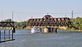
The swing span turned to allow a boat to pass
View from the Sacramento River
The Capitol Corridor reverses over the bridge while a tiki bar boat travels up the Sacramento River
↑ "Railroad Reception". Sacramento Daily Union, Volume 38, Number 5880. January 31, 1870. As it reached the eastern end of the bridge and commenced passing across the "frog," the enthusiasm of the crowd broke out in cheers loud and frequent, expressive of the pleasure felt by Sacramentans in being able to welcome the California Pacific to the city.
↑ "New Bridge at Sacramento". Morning Union, Volume 23, Number 3566, 11 September 1878. Retrieved May 11, 2025. The location will be above the present one between the city and the town of Washington, and it will be of the Howe truss style.
↑ "Bridge of 1895 at Sacramento. CSRM 5166". California State Railroad Museum Negative Collection. Third railroad bridge, built in 1895. Highway on top, railroad on bottom.
↑ "Southern Pacific Drawbridge Over Sacramento River, Sacramento, California". Sacramento Public Library, Sacramento Room Postcard Collection, BBSAC063. Shown in circa 1905 is the Southern Pacific Railroad's drawbridge along the Sacramento River. Built as a Howe truss bridge, it was composed of seven spans, the shortest at 150 feet, the longest at 200 feet. The draw, a length of 200 feet, was located closest to the Sacramento side of the river and at the deepest part of the channel. It was first crossed by Southern Pacific engine number 1022 in December 1895.
↑ "Sacramento River Crossings Alternatives Study"(PDF). City of Sacramento. Fehr & Peers, ICF International, Dokken Engineering, AIM Consulting, Endicott Communications, Inc. Retrieved February 9, 2024.
This page is based on this Wikipedia article Text is available under the CC BY-SA 4.0 license; additional terms may apply. Images, videos and audio are available under their respective licenses.