In ancient Celtic polytheism, Verbeia was a goddess worshipped in Roman Britain. She is known from a single altar-stone dedicated to her at Ilkley. She is considered to have been a deification of the River Wharfe.

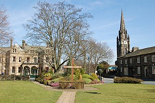
Otley is a market town and civil parish at a bridging point on the River Wharfe, in the City of Leeds metropolitan borough in West Yorkshire, England. Historically a part of the West Riding of Yorkshire, the population was 13,668 at the 2011 census. It is in two parts: south of the river is the historic town of Otley and to the north is Newall, which was formerly a separate township. The town is in lower Wharfedale on the A660 road which connects it to Leeds.

Ilkley is a spa town and civil parish in the City of Bradford in West Yorkshire, in Northern England. Historically part of the West Riding of Yorkshire, Ilkley civil parish includes the adjacent village of Ben Rhydding and is a ward within the City of Bradford. Approximately 12 miles (19 km) north of Bradford and 17 miles (27 km) north-west of Leeds, the town lies mainly on the south bank of the River Wharfe in Wharfedale, one of the Yorkshire Dales.

Arthington is a linear village in Wharfedale, in the City of Leeds metropolitan borough in West Yorkshire, England. It is a civil parish which, according to the 2011 census, had a population of 532. It is in the Otley ward of the City of Leeds, and the Leeds North West parliamentary constituency.

Tadcaster is a market town and civil parish in North Yorkshire, England, 15 miles (24 km) north-east of Leeds and 10 miles (16 km) south-west of York. Its historical importance from Roman times onward was largely as the lowest road crossing-point on the River Wharfe until the construction of the A64 Tadcaster by-pass some 660 yards (600 m) to the south, in 1978. There are two rail crossings downstream of the town before the Wharfe joins the River Ouse near Cawood.

Grassington is a village and civil parish in North Yorkshire, England. The population of the parish at the 2011 Census was 1,126. Historically part of the West Riding of Yorkshire, and now in the lieutenancy area of North Yorkshire, the village is situated in Wharfedale, about 8 miles (10 km) north-west from Bolton Abbey, and is surrounded by limestone scenery. Nearby villages include Linton, Threshfield, Hebden, Conistone and Kilnsey.

Adel is a suburb of Leeds, West Yorkshire, England. To its immediate south is Weetwood, to the west are Cookridge and Holt Park, to the east are Alwoodley and Moortown, and to the north are Bramhope, Arthington and Eccup.

Linton is a village in the civil parish of Collingham, in the City of Leeds metropolitan borough, in West Yorkshire, England. It is 1.5 miles (2.4 km) south-west of Wetherby on the north bank of the River Wharfe, Collingham is on the opposite bank.

Sherburn in Elmet is a town and civil parish in the district and county of North Yorkshire, England. It is to the west of Selby and south of Tadcaster.
Burley in Wharfedale is a village and civil parish in West Yorkshire, England, in the Wharfedale valley. In 2011, it had a population of 7,041.

Skyrack was a wapentake of the West Riding of Yorkshire, England. It was split into upper and lower divisions and centred in Headingley, Leeds. The Lower Division included the parishes of Aberford, Bardsey, Barwick-in-Elmet, Kippax, Thorner, Whitkirk and part of Harewood, while the Upper Division included the parishes of Adel, Bingley, Guiseley and parts of Harewood, Ilkley and Otley.

Clifford is a village and civil parish in West Yorkshire, England. The population of the civil parish at the 2011 Census was 1,662. The village is 3 miles (4.8 km) south of Wetherby. Many of the older buildings are built of magnesian limestone.
Weston is a village and civil parish in the former Harrogate district of North Yorkshire, England. The village is 1.2 miles (2 km) north–west of Otley and near the River Wharfe which forms the boundary between North and West Yorkshire. The name is from Old English and means western enclosure, farmstead or village.
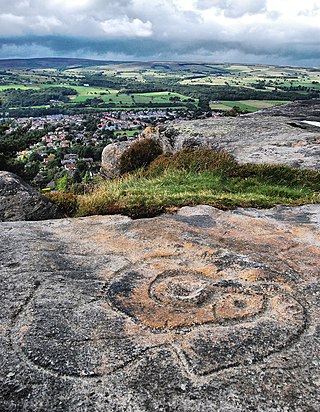
Ilkley is a town and civil parish in West Yorkshire, in the north of England. It has been inhabited since at least the Mesolithic period; was the site of a Roman fort, and much later an early example of a spa town. In more recent times it serves as a residential district within the travel to work areas of Bradford, Leeds and Keighley.

Netley Marsh is a village and civil parish in Hampshire, close to the town of Totton. It lies within the New Forest District, and the New Forest National Park. It is the supposed site of the battle between an invading Anglo Saxon army, under Cerdic and a British army under the probably fictitious king Natanleod in the year 508.

Loddiswell is a parish and village in the South Hams district of Devon, England. It lies on the west side of the River Avon or Aune and is three miles NNW from Kingsbridge. There is evidence of occupation going back to Roman times. The villages most famous son and benefactor was Richard Peek who retired here after being one of the Sheriffs of London. The name Loddiswell is a corruption of Saint Loda's well, named after one of the many saints that occurred all over the westcountry, especially in Cornwall.

Ilkley Manor House, Ilkley, West Yorkshire, England, is a local heritage museum, art gallery, and live venue, and was established in the present building in 1961 to preserve local archaeological artefacts after the spa town expanded and much Roman material was lost. It was managed by Bradford Council Museums and Galleries department but had to be closed in 2013 owing to lack of funds. In order to keep the building open to the public, the Ilkley Manor House Trust was formed, and in April 2018, Bradford Council transferred the Manor House and three adjacent cottages to the Trust as a community asset transfer.

Newton Kyme is a village in the civil parish of Newton Kyme cum Toulston near the River Wharfe, in the Selby district, in the English county of North Yorkshire. The population of the civil parish at the 2011 Census was 275. It is near the town of Tadcaster. For transport there is the A659 road nearby. Newton Kyme has a church and a castle called Kyme Castle.
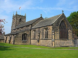
The Parish Church of All Saints in Ilkley in West Yorkshire, England is an active Anglican parish church in the archdeaconry of Bradford and the Diocese of Leeds.

Nesfield is a small village, 2 miles (3.2 km) north-west of Ilkley on the north bank of the River Wharfe, in the civil parish of Nesfield with Langbar, in the Harrogate district, in the county of North Yorkshire, England. Historically in the West Riding of Yorkshire, the village sits at the southern edge of the Nidderdale Area of Outstanding Natural Beauty.


