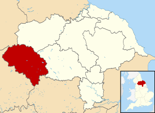
Craven was a non-metropolitan district in the west of North Yorkshire, centred on the market town of Skipton.

Grassington is a village and civil parish in North Yorkshire, England. The population of the parish at the 2011 Census was 1,126. Historically part of the West Riding of Yorkshire, and now in the lieutenancy area of North Yorkshire, the village is situated in Wharfedale, about 8 miles (10 km) north-west from Bolton Abbey, and is surrounded by limestone scenery. Nearby villages include Linton, Threshfield, Hebden, Conistone and Kilnsey.
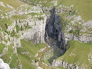
Gordale Scar is a limestone ravine 1 mile (1.6 km) north-east of Malham, North Yorkshire, England. It contains two waterfalls and has overhanging limestone cliffs over 330 feet (100 m) high. The gorge could have been formed by water from melting glaciers or a cavern collapse. The stream flowing through the scar is Gordale Beck, which on leaving the gorge flows over Janet's Foss before joining Malham Beck 2 miles (3 km) downstream to form the River Aire. A right of way leads up the gorge, but requires climbing approximately 10 feet (3 m) of tufa at the lower waterfall.

The River Dibb, also known as Barben Beck, is a small river located in North Yorkshire, England. It is a tributary of the River Wharfe. Grimwith Reservoir is at the head of the River Dibb at a point some 2.5 miles (4 km) from Appletreewick. The river flows for 5.2 kilometres (3.2 mi), and must maintain a flow of 273,000 cubic metres (9,600,000 cu ft) of water a day into the River Wharfe system.

Appletreewick is a village and civil parish in the Craven district of North Yorkshire, England, 6.5 miles (10.5 km) north-east of Skipton, 7 miles (11 km) from Skipton railway station and 16 miles (25.7 km) from Leeds Bradford International Airport.
Bordley is a village in the civil parish of Hetton-cum-Bordley, in North Yorkshire, England, within the Yorkshire Dales National Park and 12 miles (19 km) north of Skipton. According to the 2001 census the parish had a population of 23.

Broughton is a village and civil parish in the former Craven District of North Yorkshire, England. The village is on the A59 road approximately 3 miles (5 km) west of Skipton.

Skipton was a rural district in the West Riding of Yorkshire from 1894 to 1974. It was named after Skipton, which constituted an urban district on its southern border.
Thirn is a village and civil parish in North Yorkshire, England. It is situated close to the River Ure, about 3 miles (5 km) south-west of Bedale.

Gargrave is a large village and civil parish in the former Craven District located along the A65, 4 miles (6 km) north-west of Skipton in North Yorkshire, England. It is situated on the very edge of the Yorkshire Dales. The River Aire and the Leeds and Liverpool Canal pass through the village. It had a population of 1,764 in 2001 reducing slightly to 1,755 at the 2011 census.
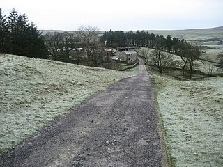
High Birkwith is a hamlet in the Craven district of North Yorkshire, England. It is located north of the village of Horton in Ribblesdale and in the same civil parish.
The River Wenning is a tributary of the River Lune, flowing through North Yorkshire and Lancashire. The name derives from the Old English Wann, meaning dark river.

Ribblesdale is one of the Yorkshire Dales in England. It is the dale or upper valley of the River Ribble in North Yorkshire. Towns and villages in Ribblesdale include Selside, Horton-in-Ribblesdale, Stainforth, Langcliffe, Giggleswick, Settle, Long Preston and Hellifield. Below Hellifield the valley of the river is generally known as the Ribble Valley.

Eshton is a small village and civil parish in the Craven district of North Yorkshire, England. At the 2011 Census the population was less than 100 and is included in the civil parish of Flasby with Winterburn. In 2015, North Yorkshire County Council estimated the population to be 70. It is in the Yorkshire Dales and about 6 miles (9.7 km) south of Grassington.

Rylstone is a village and civil parish in the former Craven district of North Yorkshire, England. It is situated very near to Cracoe and about 6 miles (9.7 km) south west of Grassington. The population of the civil parish as of the 2001 census was 122, and had risen to 160 by the time of the 2011 census. In 2015, the population was estimated to be 180.

Thornton-in-Craven is a village and civil parish in the Craven district of North Yorkshire, England. It is approx 1,740 feet (530 m) from the border with Lancashire and 1 mile (1.6 km) north of Earby. Barnoldswick is nearby. The Pennine Way passes through the village, as does the A56 road. The village has a church, a primary school and a retirement home, but no shops or pubs.

Thornton in Lonsdale is a village and civil parish in the Craven District and ceremonial county of North Yorkshire in England. It is very close to the border with Cumbria and Lancashire and is 1 mile (1.6 km) north of Ingleton and 5 miles (8.0 km) south-east of Kirkby Lonsdale, and has a population of 308, falling to 288 at the 2011 Census. Its main claims to fame are the Marton Arms pub and St Oswald's Church, Sir Arthur Conan Doyle married his first wife at this church in 1885 and held his reception at The Marton Arms before setting off to Ireland on honeymoon. Doyle's mother resided at nearby Masongill from 1882 to 1917.

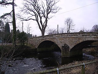
Castley is a village and civil parish in the Harrogate district of North Yorkshire, England. It lies on a bend in the River Wharfe about 10 miles (16 km) north of the centre of Leeds. The population of the civil parish was estimated at 70 in 2015. The village appears in the Domesday Book as Castleai, a combination of castel, and lēah, meaning the clearing near the fort.
West Craven is an area in the east of Lancashire, England in the far northern part of the borough of Pendle. Historically the area was within the ancient county boundaries of Yorkshire and was administered as part of the Skipton Rural District of the West Riding of Yorkshire until 1974.

Aire Gap is a pass through the Pennines in England formed by geologic faults and carved out by glaciers. The term is used to describe a geological division, a travel route, or a location that is an entry into the Aire river valley.
