
Abbey House on Abbey Road, Barrow-in-Furness, Cumbria, England is a Neo-Elizabethan H-plan mansion designed by Sir Edwin Lutyens and completed in 1914 as a guest house for Vickers Ltd and a flat for the Managing Director, Sir James McKechnie. In its abstracted, military echo of the Tudor style, it prefigures the style of Lutyens' Castle Drogo. In 1951, having been acquired by the County Council, Abbey House was made into an old people's home, and consequently suffered considerable neglect. Abbey House has been a Grade II* Listed Building since 1949.
Hindpool is an area and electoral ward of Barrow-in-Furness, Cumbria, England. It is bordered by Barrow Island, Central Barrow, Ormsgill, Parkside and the Walney Channel, the local population stood at 5,851 in 2011. The ward covers the entire western half of the town centre and includes Barrow's main shopping district. Other local landmarks include the Furness College Channelside campus, the Dock Museum and the Main Public Library. Hindpool is also home to two stadia - Barrow Raiders' Craven Park and Barrow A.F.C.'s Holker Street.

Abbey Road is the principal north to south arterial road through Barrow-in-Furness, Cumbria, England.
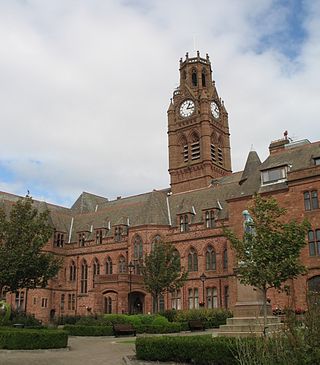
Barrow-in-Furness Town Hall is a Gothic Revival style municipal building in Barrow-in-Furness, Cumbria, England. The building, which served as the headquarters of the former Barrow Borough Council, and now one of the bases of Westmorland and Furness Council, lies within a Conservation Area with Grade II* listed status.

Furness Academy is a secondary school in Barrow-in-Furness, England. It is the fourth academy to have been formed in the county of Cumbria after the closure of Alfred Barrow School, Parkview Community College of Technology and Thorncliffe School in 2009. Having utilised numerous buildings of the former Parkview and Thorncliffe Schools since 2009, a single £22 million building opened in the Parkside area of the town in September 2013.

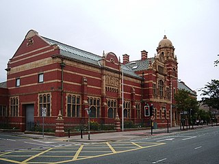
Barrow-in-Furness Main Public Library is a Grade II listed Beaux-Arts style building located at Ramsden Square, Barrow-in-Furness, England. Operated since 1974 by Cumbria County Council, it is the largest library in the town and the present structure, designed by J A Charles was originally built as a Carnegie library with support from the Carnegie Foundation.

St Mary of Furness is a Roman Catholic church located on Duke Street in Barrow-in-Furness, England. The congregation was founded in 1858, however the current building was constructed between 1866 and 1867. It is a Grade II listed building.
Duke Street is a road running through the town centre and Hindpool area of Barrow-in-Furness, England. Stretching almost one mile from east to west it connects two major A roads as well as intersecting Abbey Road roughly midway. Designed by Sir James Ramsden as the centrepiece of the 19th century planned town of Barrow, Duke Street is home to three squares alongside many listed buildings including Barrow Town Hall and the Main Public Library. The Forum performing arts centre and Craven Park Stadium are also located on Duke Street.
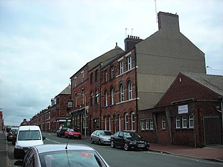
The Nan Tait Centre is a Grade II listed building located at Abbey Road in the Hindpool area of Barrow-in-Furness, Cumbria, England.

The Furness Abbey Hotel was demolished in 1953, having been bombed in May 1941. Its site now forms the car park to Furness Abbey and the museum. The station at Furness Abbey also suffered bomb damage and was demolished in the early 1950s. The original station booking office and refreshment room, built in 1862, which had been attached to the hotel, survives as The Abbey Tavern, standing in Abbey Approach, Barrow-in-Furness, Cumbria, England, to the north of the remains of Furness Abbey. The current structure is recorded in the National Heritage List for England as a designated Grade II listed building.

The John Whinnerah Institute is a Grade II listed Art Deco building and former educational establishment located on Abbey Road in Barrow-in-Furness, England. Having been constructed between 1937 and 1938 on the site of the demolished Jute Works it is the newest listed structure in the town, despite this it was drastically altered in 2004 when the entire interior was demolished to accommodate new retail units leaving only the Abbey Road and Hindpool Road facades.

The National Westminster Bank building in Barrow-in-Furness, Cumbria, England is located at the intersection of Abbey Road and Duke Street. It was designed by Paley and Austin architects and built between 1873–74 and has been designated a Grade II listed building by English Heritage. Built for the Lancaster branch of the National Westminster Bank it was a major component of the Ramsden Square scheme, one of the planned town's two main squares and focal points. It is one of three former 'Nat West' properties with listed building status in the Borough and currently houses a carpet shop in the lower floors.

Ramsden Hall located at 48 Abbey Road in Barrow-in-Furness, Cumbria, England is a Grade II listed former public bath house. Funded by industrialist and local mayor Sir James Ramsden it was constructed in 1872 and was relatively small in comparison to other public baths in Barrow. Despite no longer serving its original purpose Ramsden Hall stands as the only remaining example of a 19th-century public bath in the town. For a period of its history, the building served as an annexe of the adjacent Technical School although at present it is occupied by offices of the Citizens Advice Bureau.

The Custom House in Barrow-in-Furness, Cumbria, England is a former government building, having housed the customs offices for trade handled at the Ports of Barrow and Lancaster. Initially constructed as a hotel around 1870, it took on its most notable role as a custom house in 1880, regulating custom from the Port of Lancaster.

The Central Fire Station on Abbey Road in Barrow-in-Furness, Cumbria, England is a Grade II listed former fire station that has been described by Historic England as a "well-preserved example of the first generation of fire station built specifically for motorised appliances". Constructed in 1911 and opening a year later, the building served as the town's only station until Cumbria Fire and Rescue Service completed their first new-build station on Phoenix Road in 1996. The building is noted for its striking red brick facades and buff terracotta dressings, it bears a strong resemblance to the Technical School built less than 10 years prior nearby on the opposite side of Abbey Road. The building has since been converted into a 'Bed Brigade' store.
St. George's Square, in Barrow-in-Furness, Cumbria, England is a public space that acted as the centre of the town during the late 19th century. The square now lies in the southernmost fringes of the Central ward close to the Port of Barrow.

Barrow-in-Furness Strand railway station was the first permanent railway terminus to be built in Barrow-in-Furness, England. Located on the Strand at St. George's Square close to the town's docks its functioning life was short, however the building itself continued to be used as the headquarters of the Furness Railway for a number of years. The station opened in 1863 having replaced a wooden structure which was erected in 1846 at adjacent Rabbit Hill. The station at St. George's square ceased commercial operations in 1882 upon the completion of a new loop line and much larger station at Abbey Road. Barrow-in-Furness Central railway station, later simply renamed Barrow-in-Furness railway station has been the town's primary station ever since.
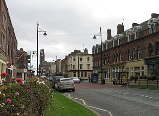
Schneider Square is a square located at the intersection of Duke Street, Dalton Road, Michaelson Road, Burlington Street and Fisher's Yard in Barrow-in-Furness, Cumbria, England. Schneider Square has changed little since its construction in the mid-19th century and now lies within a conservation area. Named after Henry Schneider who played a major role in the development of Barrow, there is a statue commemorating the industrialist in the centre of the square. Located on, or immediately adjacent to Schneider Square are Barrow Town Hall, Craven House, former Barrow Higher Grade School, Hotel Majestic, Burlington House and Duke Street Surgery.

Piel railway station was the terminus of the Furness Railway's Piel Branch in Barrow-in-Furness, England that operated between 1846 and 1936. Located on Roa Island it was built to serve the passenger steamers at Piel Pier. The Roa Island causeway was specifically constructed for the railway, in turn making the island part of the British mainland. The station and the Piel Branch line have both been demolished, however the Roa Island Hotel which was built adjoining the station survives to this day as a Grade II listed building.

The Majestic Hotel located at Schneider Square in Barrow-in-Furness, Cumbria, England is a 3-star Grade II listed hotel constructed in 1904. The building was designed by JY McIntosh and contains elements of Edwardian and Jacobean architecture. It is also noted for its striking rounded Flemish gables. £1.7 million was spent on refurbishing the hotel in 2008 by developers One Leisure, although ownership of the Majestic, and its nearby sister hotel the Imperial, have since been transferred. The majority of the building's ground floor level is occupied by an Italian restaurant named Francesca's.
