| Name | Image | Location | Year Completed | Year Listed | Historic England Description |
|---|
| 1 Chase End, Cross Lane |  | Hawcoat | c. 18th century | 1976 | CHASE END 1 |
| 1 Dorcas Avenue |  | Newbarns | c. 19th century | 1976 | 1 |
| 1 Newbarns Village |  | Newbarns | c. 18th century | 1976 | 1 |
| 1 North Scale | | North Walney (North Scale) | 1684 | 1976 | 1 |
| 1 Roosecote-Dungeon Lane, Barn | | Roose | c. 17th century | 1993 | BARN IMMEDIATELY TO SOUTH WEST OF NUMBER 1 ROOSECOTE |
| 1 Roosecote-Dungeon Lane, Farmhouse | | Roose | c. 17th century | 1949 | ROOSECOTE 1 |
| 1 Skelgate | | Dalton South | c. 18th century | 1976 | 1, SKELGATE |
| 1 St. George's Square |  | Central Barrow | 1864 | 1976 | 1 |
| 1 and 2 Market Place | | Dalton South | c. 19th century | 1976 | 1 AND 2, MARKET PLACE |
| 1-5 Castle Street | | Dalton South | c. 18th century | 1976 | NUMBER 2 PART |
| 1-41 Parade Street |  | Central Barrow | 1896 | 1976 | 1-41 |
| 1-8 Piel Island | | Roose (Piel Island) | 1875 | 1976 | 1-8 PIEL ISLAND |
| 1-9 Barque Street |  | Barrow Island | 1884 | 1993 | BARQUE STREET TENEMENTS 1-9 |
| 1-9 Brig Street | | Barrow Island | 1884 | 1993 | BRIG STREET TENEMENTS 1-9 |
| 1-9 Schooner Street |  | Barrow Island | 1884 | 1993 | SCHOONER STREET TENEMENTS 1-9 |
| 1-9 Ship Street |  | Barrow Island | 1884 | 1993 | SHIP STREET TENEMENT 1-9 |
| 10 Biggar Village | | South Walney (Biggar) | c. 19th century | 1976 | RAINBOW COTTAGE 10 |
| 10 Hector Street | 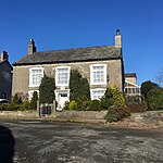 | Newbarns | c. 18th century | 1976 | HECTOR HOUSE 10 |
| 101, 103, 105, 107 and 109 Duke Street |  | Central Barrow | 1865 | 1975 | 101-109 |
| 11 Market Street | | Dalton South | 1870 | 1993 | 11, MARKET STREET |
| 111, 113, 115, 117 and 119 Duke Street |  | Central Barrow | 1870 | 1976 | 111-119 |
| 113-119 Rawlison Street, Former Police Station | | Central Barrow | 1880 | 1976 | 113-119 |
| 12 Biggar Village | | South Walney (Biggar) | c. 17th century | 1976 | HILL FARMHOUSE 12 |
| 12 Cross Lane | | Hawcoat | c. 18th century | 1975 | 12 |
| 121 and 122 Duke Street |  | Central Barrow | 1873 | 1976 | THE LORD RAMSDEN PUBLIC HOUSE 121 AND 122 |
| 125 Duke Street |  | Central Barrow | 1873 | 1976 | 125 |
| 127, 129 and 131 Duke Street |  | Central Barrow | 1873 | 1976 | 127, 129 AND 131 |
| 13, 14 and 15 Market Street | | Dalton South | c. 19th century | 1976 | ATTACHED OUTBUILDINGS TO NUMBER 15 BALDWIN HOUSE |
| 14 North Scale | | North Walney (North Scale) | 1751 | 1976 | 14 |
| 14 North Scale, Farm Buildings | | North Walney (North Scale) | c. 18th century | 1993 | FARM BUILDINGS IMMEDIATELY TO SOUTH EAST OF NUMBER 14 |
| 14 Tower Street | | Roose (Roa Island) | c. 19th century | 1976 | TOWER HOUSE 14 |
| 14-20 Salthouse Road |  | Central Barrow | 1849 | 1976 | 14-20 |
| 143 Salthouse Road | | Central Barrow | c. 19th century | 1976 | 143 |
| 143 Salthouse Road, Barn | | Central Barrow | c. 18th century | 1976 | BARN IMMEDIATELY TO WEST OF NUMBER 143 |
| 145 and 147 Salthouse Road | | Central Barrow | c. 17th century | 1976 | 145 AND 147 |
| 148, 150 and 152, Market Street | | Dalton South | c. 18th century | 1976 | 148, 150 AND 152, MARKET STREET |
| 151 Salthouse Road | | Central Barrow | 1802 | 1976 | 151 |
| 153 Salthouse Road and Farm Buildings | | Central Barrow | c. 18th century | 1976 | NUMBER 153 WITH ADJOINING FARM BUILDINGS |
| 16 Market Street | | Dalton South | c. 18th century | 1976 | 16, MARKET PLACE |
| 16 and 16A, Tudor Square | | Dalton South | c. 18th century | 1976 | 16 AND 16A, TUDOR SQUARE |
| 16, 18 and 20, Market Street | | Dalton South | c. 18th century | 1976 | 16, 18 AND 20, MARKET STREET |
| 17 Market Street | | Dalton South | c. 18th century | 1976 | 17, MARKET STREET |
| 17 Roanhead Lane | 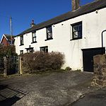 | Hawcoat | c. 18th century | 1976 | NUMBER 17 AND ATTACHED OUTBUILDING |
| 18 Market Street | | Dalton South | c. 18th century | 1976 | 16, MARKET PLACE |
| 18, 19 and 20, Tudor Square | | Dalton South | c. 18th century | 1976 | 18, 19 AND 20, TUDOR SQUARE |
| 19 Biggar Village | | South Walney (Biggar) | c. 18th century | 1976 | 19 |
| 19 Biggar Village, Barn | | South Walney (Biggar) | c. 18th century | 1976 | BARN TO SOUITH EAST OF NUMBER 19 |
| 19 Market Street | | Dalton South | c. 19th century | 1976 | NUMBER 19 WITH ATTACHED BARN AND FRONT GARDEN WALL |
| 19A and 19B Market Street | | Dalton South | c. 19th century | 1976 | 19, 19A AND 19B, MARKET PLACE |
| 19 Newbarns Village |  | Newbarns | 1770 | 1976 | 19 |
| 19 North Scale | | North Walney (North Scale) | 1762 | 1976 | 19 |
| 2 Biggar Village, Farm Buildings | | South Walney (Biggar) | c. 17th century | 1976 | RANGE OF FARM BUILDINGS ATTACHED TO NUMBER 2 |
| 2 Roosecote-Dungeon Lane | | Roose | c. 17th century | 1949 | ROOSECOTE 2 |
| 2 Skelgate | | Dalton South | c. 18th century | 1976 | 2, SKELGATE |
| 2, 2A and 4, Market Street | | Dalton South | c. 18th century | 1976 | 2, 2A, AND 4, MARKET STREET |
| 2-10 Salthouse Road | | Central Barrow | 1846 | 1976 | 2-10 |
| 2-46 Keith Street |  | Central Barrow | 1895 | 1976 | 2-46 |
| 20 North Scale and Farm Buildings | | North Walney (North Scale) | 1728 | 1975 | NUMBER 20 WITH ATTACHED FRONT GARDEN WALL AND ATTACHED BARN AND SHIPPONS |
| 22, 24 and 26, Market Street | | Dalton South | c. 18th century | 1976 | 22, 24 AND 26, MARKET STREET |
| 2, 3 and 4, King's Mount | | Dalton South | c. 19th century | 1976 | NUMBERS 2,3 AND 4 AND ATTACHED STABLE |
| 24-28 The Green | | Dalton North (Lindal-in-Furness) | c. 19th century | 1976 | 24-28, THE GREEN |
| 28 North Scale and Farm Buildings | | North Walney (North Scale) | 1725 | 1976 | NUMBER 28 WITH ATTACHED STABLES |
| 2-8, Ulverston Road | | Dalton South | c. 19th century | 1976 | 2-8, ULVERSTON ROAD |
| 298 Abbey Road | | Newbarns | 1878 | 1976 | 298 ABBEY ROAD |
| 3 Market Street | | Dalton South | c. 17th century | 1976 | 3, MARKET STREET |
| 3 Roosecote-Dungeon Lane | | Roose | c. 17th century | 1949 | ROOSECOTE 3 |
| 3-51 Keith Street | | Central Barrow | 1865 | 1976 | 3-51 |
| 30-34 The Green | | Dalton North (Lindal-in-Furness) | c. 19th century | 1976 | 30-34, THE GREEN |
| 32 Robert Street | | Hindpool | 1870 | 1976 | 32 |
| 33 Market Street | | Dalton South | c. 19th century | 1976 | 33, MARKET STREET |
| 36 Dalton Road | | Hindpool | c. 1880s | 1976 | 36 |
| 4 Duke Street, Duke Street Surgery |  | Central Barrow | c.20th century | 1976 | 4 |
| 4 Market Place | | Dalton South | c. 19th century | 1976 | 4, MARKET PLACE |
| 4 Newbarns Village |  | Newbarns | c. 19th century | 1976 | NUMBER 4 NEW BARNS VILLAGE |
| 44 Market Street | | Dalton South | c. 18th century | 1976 | 44, MARKET STREET |
| 46 Market Street | | Dalton South | c. 19th century | 1976 | 46, MARKET STREET |
| 47, 49 and 51, Market Street | | Dalton South | c. 19th century | 1976 | 47, 49 AND 51, MARKET STREET |
| 6 Biggar Village | | South Walney (Biggar) | c. 18th century | 1976 | MANOR FARMHOUSE 6 |
| 6 Market Place | | Dalton South | c. 18th century | 1976 | NUMBER 6 WITH ATTACHED FRONT GARDEN WALL |
| 6-26 School Street |  | Central Barrow | c. 19th century | 1976 | 6-26 |
| 63, 65 and 67 Duke Street |  | Central Barrow | 1865 | 1976 | 63, 65 AND 67 |
| 7 and 8 The Green | | Dalton North (Lindal-in-Furness) | c. 19th century | 1976 | 7 AND 8, THE GREEN |
| 77 and 79 Duke Street | | Central Barrow | 1865 | 1976 | 77 AND 79 |
| 8 Biggar Village | | South Walney (Biggar) | c. 18th century | 1976 | SQUIRE'S COTTAGE 8 |
| 81, 83, 85, 87 and 89 Duke Street | | Central Barrow | 1865 | 1976 | 81-89 |
| 9-12 The Green | | Dalton North (Lindal-in-Furness) | c. 19th century | 1976 | 9-12, THE GREEN |
| 92, 94 and 96 Duke Street |  | Hindpool | 1875 | 1993 | BARCLAYS BANK 92, 94 AND 96 |
| 96 Market Street | | Dalton South | c. 19th century | 1993 | NUMBER 96 AND FRONT GARDEN WALL |
| Abbey Approach Gateway |  | Newbarns | 1873 | 1976 | GATEWAY TO ABBEY APPROACH |
| Abbey Gate Cottages | | Newbarns | 1873 | 1976 | ABBEY GATE COTTAGES |
| Abbey Road Conservative Club |  | Hindpool | 1899 | 1976 | CONSERVATIVE CLUB |
| Abbey Road Working Men's Club |  | Hindpool | 1871 | 1976 | WORKING MEN'S CLUB AND INSTITUTE |
| Abbot's Wood House | | Roose | 1877 | 1974 | HOME FARMHOUSE AND ATTACHED FARM BUILDINGS |
| Abbot's Wood Perimeter Wall | | Roose | 1877 | 1974 | KITCHEN GARDEN PERIMETER WALL AT HOME FARM |
| Abbot's Wood South Lodge | 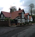 | Roose | 1873 | 1973 | SOUTH LODGE AT ABBOTSWOOD (NOT INCLUDED) |
| Alfred Barrow School, Central Block | 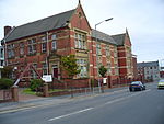 | Central Barrow | 1888 | 1993 | ALFRED BARROW SCHOOL, CENTRE BLOCK |
| Anvil House | | Dalton North (Askam and Ireleth) | c. 19th century | 1976 | ANVIL HOUSE |
| Ashburner House | | Dalton North | 1895 | 1993 | ASHBURNER HOUSE AT DOWDALES SCHOOL |
| Askam railway station east waiting room |  | Dalton North (Askam and Ireleth) | c.20th century | 1989 | WAITING ROOM ON EAST SIDE OF LINE AT ASKAM IN FURNESS RAILWAY STATION |
| Askam railway station signal box and walls |  | Dalton North (Askam and Ireleth) | c. 19th century | 1989 | SIGNAL BOX AND ATTACHED WALLING AT ASKAM IN FURNESS RAILWAY STATION |
| Askam railway station ticket office and waiting room |  | Dalton North (Askam and Ireleth) | 1877 | 1989 | TICKET OFFICE AND WAITING ROOM AT ASKAM IN FURNESS RAILWAY STATION |
| Bank and Church House | | Dalton South | c. 18th century | 1976 | BANK HOUSE CHURCH HOUSE |
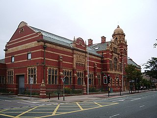
| Barrow Main Public Library |  | Hindpool | 1874 | 1922 | PUBLIC LIBRARY, MUSEUM AND FORECOURT WALL AND RAILINGS FACING RAMSDEN SQUARE |
| Beckside Conservative Club | | Dalton South | c. 19th century | 1950 | BECKSIDE CONSERVATIVE CLUB |
| Bow Bridge |  | Newbarns | 1500s | 1993 | BRIDGE OVER MILL BECK AND ATTACHED GATEWAY AT ABBEY DALE |
| Bow Windows Farm | | Roose (Rampside) | 1654 | 1976 | BOW WINDOWS FARMHOUSE AND ATTACHED FARMBUILDINGS |
| Brook Lea | | Dalton North (Askam and Ireleth) | c. 19th century | 1976 | BROOK LEA |
| Brookside | | Dalton North (Askam and Ireleth) | c. 18th century | 1976 | BROOKSIDE |
| Burlington House | | Central Barrow | 1890 | 1976 | BURLINGTON HOUSE |
| Cenotaph | 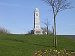 | Parkside | 1919 | 1976 | WAR MEMORIAL IN PUBLIC PARK |
| Castle View | | Dalton South | c. 19th century | 1976 | CASTLE VIEW |
| Central Fire Station |  | Central Barrow | 1911 | 1991 | CENTRAL FIRE STATION |
| Chappells Tavern | | Dalton North | 1892 | 1976 | CHAPPELLS TAVERN |
| Chetwynde School, Main Building | | Newbarns | 1865 | 1976 | OUR LADY'S SCHOOL, CROSSLANDS CONVENT |
| Cooke's Buildings |  | Hindpool | 1875 | 1976 | COOKE'S BUILDINGS |
| Cornerstone House | | Dalton North | 1870 | 1976 | CORNERSTONE HOUSE |
| Crofters Cow House and Barn | | Roose | c. 18th century | 1978 | COW HOUSE AND BARN WITH ATTACHED HORSE ENGINE HOUSE NORTH EAST OF CROFTERS PUBLIC HOUSE |
| Crofters Cow House and Shelter Shed | | Roose | c. 19th century | 1978 | FORMER COW HOUSE AND ATTACHED SHELTER SHED IMMEDIATELY NORTH OF CROFTERS PUBLIC HOUSE |
| Crofters Garden Wall | | Roose | c. 19th century | 1978 | WALL ENCLOSING GARDEN TO FRONT AND SOUTH SIDE OF CROFTERS PUBLIC HOUSE |
| Crofters Pigsties and Wall | | Roose | c. 19th century | 1978 | GROUP OF 3 FORMER PIGSTIES AND MIDDEN WALL AT CROFTERS PUBLIC HOUSE |
| Crofters Public House | | Roose | 1828 | 1978 | CROFTERS PUBLIC HOUSE |
| Crosslands Lodge | 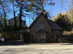 | Newbarns | 1875 | 1976 | LODGE TO CROSSLANDS |
| Custom House | | Central Barrow | 1870 | 1976 | ST MARY'S CLUB |
| Dalton Cemetery North Chapel |  | Dalton South | 1862 | 1993 | DALTON CEMETERY, NORTHERNMOST CHAPEL |
| Dalton House | | Dalton South | 1840 | 1976 | DALTON HOUSE |
| Former Dalton Public Library | | Dalton North | 1903 | 1993 | FORMER DALTON PUBLIC LIBRARY |
| Dalton War Memorial |  | Dalton South | 1922 | 1993 | WAR MEMORIAL |
| Dane Gill Beck Bridge | | Newbarns | 1887 | 1993 | JUBILEE BRIDGE |
| Drigg Farmhouse and Barn | | Dalton North (Lindal-in-Furness) | 1635 | 1950 | DRIGG AND IRTON CHURCH FARMHOUSE AND ATTACHED BARN |
| Drinking fountain at Breast Mill Beck/ Abbey Road |  | Hawcoat | 1876 | 1976 | DRINKING FOUNTAIN AT JUNCTION WITH ABBEY ROAD |
| Duke of Edinburgh Hotel |  | Hindpool | 1875 | 1976 | DUKE OF EDINBURGH HOTEL |
| Eastwood House | | Roose (Rampside) | c. 19th century | 1993 | EASTWOOD HOUSE |
| Elliscale Farm Cow House and Barn | | Dalton North | c. 18th century | 1976 | BARNS AND COW HOUSE TO SOUTH OF FARMYARD AT ELLISCALE FARM |
| Elliscale Farm Garden Wall | | Dalton North | c. 18th century | 1976 | GARDEN WALL TO SOUTH AND WEST OF ELLISCALE FARMHOUSE INCLUDING FARM BUILDING ATTACHED TO SOUTH WEST |
| Elliscale Farmhouse | | Dalton North | c. 17th century | 1976 | ELLISCALE FARMHOUSE |
| Empire House | | Dalton South | c. 18th century | 1976 | EMPIRE HOUSE |
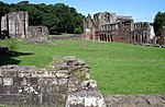
| Former Custodian's Cottage | | Newbarns | c. 15th century | 1993 | FURNESS ABBEY, FORMER CUSTODIAN'S COTTAGE |
| Former Mine Ancillary Block | | Roose (Stank) | 1875 | 1976 | FORMER MINE BUILDING IMMEDIATELY TO NORTH OF GLENFIELD HOUSE |
| Furness Abbey Cottage |  | Newbarns | 1873 | 1983 | FURNESS ABBEY COTTAGE |
| Gate Farmhouse and Farm Buildings | | Dalton North (Marton) | c. 17th century | 1976 | GATE FARMHOUSE AND ATTACHED FARM BUILDINGS |
| Glenfield House, Former Mining Offices | | Roose (Stank) | 1875 | 1976 | GLENFIELD HOUSE |
| Gravestone to George Romney | | Dalton South | 1802 | 1976 | GRAVESTONE TO GEORGE ROMNEY APPROXIMATELY 12 METRES SOUTH OF CHURCH OF ST MARY |
| Graving Dock within the Dock Museum |  | Hindpool | 1872 | 1993 | GRAVING DOCK |
| Harbour Hotel |  | Central Barrow | 1850 | 1976 | HARBOUR HOTEL |
| High Farmhouse | | Dalton North (Lindal-in-Furness) | 1879 | 1976 | HIGH FARMHOUSE |
| Hill Rise | | Dalton South | c. 18th century | 1977 | HILL RISE |
| Hotel Imperial | | Central Barrow | 1875 | 1976 | HOTEL IMPERIAL |
| Hotel Imperial, External Lanterns | | Central Barrow | c. 19th century | 1976 | PAIR OF LAMP STANDARDS OUTSIDE ENTRANCE TO HOTEL IMPERIAL |
| John Whinnerah Institute |  | Hindpool | 1938 | 2001 | THE JOHN WHINNERAH INSTITUTE BUILDING WITH GATE PIERS TO FRONT AND BICYCLE SHED IN REAR WALL |
| Lime Kiln | | Dalton North | c. 18th century | 1993 | LIME KILN AT NGR 2321 7468 |
| Lindal Moor Farmhouse and Farm Buildings | | Dalton North (Lindal-in-Furness) | c. 17th century | 1976 | LINDAL MOOR FARMHOUSE AND ATTACHED FARM BUILDINGS |
| Lindal Village Hall | | Dalton North (Lindal-in-Furness) | 1875 | 1976 | BUCCLEUCH HALL |
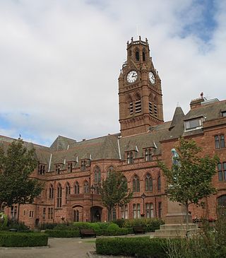
| Dalton Town Hall (Local Board Offices) | | Dalton South | 1884 | 1976 | FORMER LOCAL BOARD OFFICES |
| Local Board Offices Outbuildings | | Dalton South | 1884 | 1993 | OUTBUILDINGS TO REAR OF FORMER LOCAL BOARD OFFICES |
| Low Brookside | | Dalton North (Askam and Ireleth) | 1688 | 1976 | LOW BROOKSIDE |
| Low Farmhouse | | Dalton North (Lindal-in-Furness) | 1883 | 1976 | LOW FARMHOUSE |
| Hotel Majestic | | Central Barrow | 1904 | 1976 | HOTEL MAJESTIC |
| Manor Farmhouse |  | Newbarns | 1845 | 1976 | MANOR FARMHOUSE |
| Market Cross and Benches | | Dalton South | 1870 | 1976 | MARKET CROSS AND STONE BENCHES |
| Market Place Drinking Fountain | | Dalton South | 1897 | 1976 | DRINKING FOUNTAIN |
| Marton Hall and Farm Buildings | | Dalton North (Marton) | c. 18th century | 1976 | MARTON HALL AND ATTACHED FARM BUILDINGS |
| Millwood House | | Hawcoat | 1860 | 1992 | MILLWOOD |
| Moorhead Farm | | Roose (Rampside) | 1719 | 1976 | NUMBER 1 MOORHEAD COTTAGES AND ATTACHED BARN |
| Nan Tait Centre |  | Hindpool | 1903 | 1976 | COLLEGE OF FURTHER EDUCATION ANNEXE INCLUDING FRONT RAILINGS AND PIERS |
| National Westminster Bank |  | Hindpool | 1874 | 1976 | NATIONAL WESTMINSTER BANK |
| Natwest Bank and Chambers | | Dalton South | 1895 | 1993 | NATWEST BANK AND BANK CHAMBERS |
| New Inn | | South Walney (Biggar) | 1758 | 1976 | NEW INN AND ATTACHED BUILDINGS |
| North Lodge, Abbey House | | Newbarns | 1914 | 1976 | NORTH LODGE TO ABBEY HOUSE |
| Oakdene | | Dalton South | 1683 | 1976 | OAKDENE |
| Old School House, Walney Promenade | | South Walney (Vickerstown) | 1856 | 1973 | OLD SCHOOL HOUSE |
| Ormsgill Farm Buildings | | Ormsgill | c. 18th century | 1949 | BARN AND OUTBUILDING ADJOINING ORMSGILL FARMHOUSE |
| Oxford Chambers | | Hindpool | 1875 | 1976 | OXFORD CHAMBERS |
| Pinfold | | Dalton South | c. 18th century | 1993 | PINFOLD |
| Porter's Lodge | | Newbarns | 1873 | 1976 | ABBEY DALE |
| Public Library Telephone Booths | | Hindpool | 1935 | 1987 | PAIR OF K6 TELEPHONE KIOSKS ADJACENT TO PUBLIC LIBRARY |
| Queen's Arms Hotel |  | South Walney (Biggar) | c. 17th century | 1976 | QUEEN'S ARMS HOTEL |
| Queen's Arms Hotel, Adjacent Barn | | South Walney (Biggar) | c. 18th century | 1976 | BARN FACING SOUTH SIDE OF QUEEN'S ARMS HOTEL |
| Railwaymen's Club |  | Central Barrow | 1865 | 1976 | RAILWAYMEN'S CLUB AND PREMISES OF HSP PRINTING |
| Rampside Lighthouse |  | Roose (Rampside) | 1875 | 1991 | NUMBER 4 LEADING LIGHT ON FORESHORE NEAR RAMPSIDE HALL |
| Ramsden Hall |  | Hindpool | 1872 | 1976 | RAMSDEN HALL |
| Red Lion Hotel | | Dalton South | c. 17th century | 1977 | RED LION HOTEL |
| Roa Island Hotel |  | Roose (Roa Island) | c. 19th century | 1976 | ROA ISLAND HOTEL |
| Roa Island Watch Tower | | Roose (Roa Island) | 1849 | 1976 | WATCH TOWER |
| Romney Cottage | | Ormsgill | c. 18th century | 1976 | ROMNEY COTTAGE |
| Rose Cottage | | Dalton South | c. 18th century | 1976 | ROSE COTTAGE |
| Rose Cottage, Former Mine Lodge | | Roose (Stank) | 1875 | 1976 | ROSE COTTAGE |
| Sandylands Farm |  | Newbarns | 1623 | 1976 | SANDYLANDS FARMHOUSE AND ATTACHED BARN |
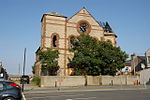
| Seventh Day Adventist Church | | Dalton South | 1868 | 1976 | SEVENTH DAY ADVENTIST CHURCH WITH ATTACHED RAILINGS |
| Shipyard Engineering Workshop |  | Barrow Island | c.20th century | 1993 | HEAVY ENGINEERING SHOP AT VICKERS SHIP AND ENGINEERING LIMITED |
| Shipyard Kings Gate Entrance and National Westminster Bank Building |  | Barrow Island | 1913 | 1993 | WORKS ENTRANCE LODE AND GATEWAY AT VICKERS SHIP AND ENGINEERING LIMITED KINGS GATE INCLUDING NATIONAL WESTMINSTER BANK |
| Shipyard Offices and Barrow Island Entrance Gateway |  | Barrow Island | 1913 | 1993 | FRONT RANGE ADO BUILDING, LODGE, GATEWAY AND RAILINGS AT VICKERS SHIP AND ENGINEERING LIMITED ENGINE GARTEWAY |
| Shipyard Office Buildings |  | Barrow Island | 1872 | 1976 | GENERAL OFFICES, TECHNICAL/COMMERCIAL, AT VICKERS SHIP AND ENGINEERING LIMITED |
| Sink Fall Farm | 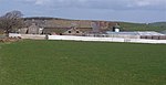 | Hawcoat | c. 18th century | 1976 | SINK FALL FARMHOUSE WITH ATTACHED FARM BUILDINGS |
| South End Farm | | South Walney (Biggar) | 1764 | 1976 | SOUTH END FARMHOUSE AND ATTACHED FARM BUILDINGS |
| Sowerby Hall Farmhouse | | Ormsgill | 1880 | 1976 | SOWERBY HALL FARMHOUSE |
| Sowerby Lodge | | Ormsgill | c. 17th century | 1976 | SOWERBY LODGE FARMHOUSE |
| Sowerby Lodge Barn | | Ormsgill | c. 18th century | 1976 | BARN IMMEDIATELY TO NORTH EAST OF SOWERBY LODGE FARMHOUSE |
| St. John's Church Of England Church |  | Barrow Island | 1935 | 1993 | CHURCH OF ST JOHN |
| St. George's Church of England Church |  | Central Barrow | 1861 | 1976 | CHURCH OF ST GEORGE |
| St. George's Church of England Primary School |  | Hindpool | 1849 | 1976 | ST GEORGES CHURCH OF ENGLAND PRIMARY SCHOOL |
| St. George's House |  | Central Barrow | 1860 | 1973 | ST GEORGE'S HOUSE |
| St. Mary's Cottage | | Dalton South | c. 19th century | 1976 | ST MARY'S COTTAGE |
| St. Mary of Furness Presbytery | 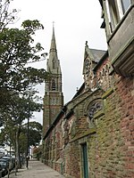 | Hindpool | c.20th century | 1976 | PRESBYTERY TO CHURCH OF ST MARY OF FURNESS WITH WALL CONNECTING TO |
| St. Mary of Furness Roman Catholic Church |  | Hindpool | 1867 | 1976 | CHURCH OF ST MARY OF FURNESS |
| St. Mary the Virgin Church Of England Church |  | South Walney (Vickerstown) | 1908 | 1976 | CHURCH OF ST MARY |
| St. Mary's Vicarage | | Dalton South | c. 19th century | 1976 | THE VICARAGE, VICARAGE COTTAGE AND ATTCACHED FRONT GARDEN WALL |
| St. Peter's Church | 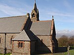 | Dalton North (Askam and Ireleth) | 1865 | 1993 | CHURCH OF ST PETER |
| St. Peter's Church | 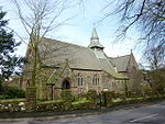 | Dalton North (Lindal-in-Furness) | 1886 | 1993 | CHURCH OF ST PETER |
| Stank Farm | | Roose (Stank) | c. 17th century | 1976 | STANK FARMHOUSE AND ATTACHED FARM BUILDINGS |
| Stank Farm Cow House | | Roose (Stank) | c. 18th century | 1976 | BARN ON ROADSIDE TO NORTH WEST OF STANK FARMHOUSE |
| Stank Iron ore Mines Entrance | | Roose (Stank) | 1875 | 1976 | ENTRANCE GATEWAYS TO GLENFIELD HOUSE INCLUDING ATTACHED SIDE GATE TO ROSE COTTAGE |
| Stank Mines Engine House | | Roose (Stank) | 1875 | 1976 | ENGINE HOUSE AT NGR SD 2325 7080 TO NORTH EAST OF GLENFIELD HOUSE |
| Statue of Henry Schneider, Schneider Square | 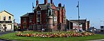 | Central Barrow | 1891 | 1976 | STATUE OF HENRY SCHNEIDER |
| Statue of Lord Frederick Cavendish |  | Central Barrow | 1885 | 1976 | STATUE OF LORD FREDERICK CAVENDISH AT JUNCTION WITH NORTH ROAD |
| Statue of Sir James Ramsden, Ramsden Square |  | Hindpool | 1872 | 1976 | STATUE OF SIR JAMES RAMSDEN |
| The Abbey Tavern | 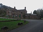 | Newbarns | c. 19th century | 1993 | THE ABBEY TAVERN |
| The Cavendish Arms Public House | | Dalton South | 1855 | 1976 | THE CAVENDISH ARMS PUBLIC HOUSE |
| The Clarence Inn | | Dalton South | c. 19th century | 1976 | THE CLARENCE INN |
| The Concle Public House | | Roose (Rampside) | c. 19th century | 1976 | THE CONCLE PUBLIC HOUSE |
| The Ship Inn | | Roose (Piel Island) | c. 18th century | 1976 | THE SHIP INN |
| The White Horse Public House |  | Dalton South | c. 19th century | 1976 | THE WHITE HORSE PUBLIC HOUSE |
| Thorncliffe Crematorium, Gate House |  | Ormsgill | 1874 | 1993 | BOROUGH CEMETERY GATE HOUSE AND ATTACHED RAILINGS |
| Thorncliffe Crematorium, North Lodge |  | Ormsgill | 1874 | 1993 | BOROUGH CEMETERY GATE HOUSE AND ATTACHED RAILINGS |
| Thorncliffe Crematorium, Roman Catholic Chapel | | Ormsgill | 1872 | 1993 | ROMAN CATHOLIC CEMETERY CHAPEL AT BOROUGH CEMETERY |
| Thwaite Flat Farmhouse | | Hawcoat | c. 18th century | 1976 | THWAITE FLAT FARMHOUSE |
| Victoria Hall |  | Hindpool | 1888 | 1991 | VICTORIA HALL |
| Victoria Memorial Fountain |  | Dalton North (Askam and Ireleth) | 1897 | 1993 | DRINKING FOUNTAIN NEAR RAILWAY CROSSING |
| Victoria Park Hotel | 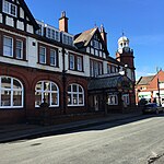 | Parkside | c.20th century | 1976 | VICTORIA PARK HOTEL |
| Waver Cottage | | Roose (Rampside) | c. 19th century | 1976 | WAVER COTTAGE 30 |
| Wesleyan Sunday School | | Dalton North | 1896 | 1993 | FORMER WESLEYAN SUNDAY SCHOOL |
| West Gate Cottage |  | Newbarns | 1873 | 1976 | WEST GATE COTTAGE |
| West Lodge, Abbey House |  | Newbarns | 1914 | 1976 | WEST LODGE TO ABBEY HOUSE WITH ATTACHED GATEHOUSE AND WING WALLS |
| Working Men's Club and Institute | | Hindpool | 1871 | 1976 | WORKING MEN'S CLUB AND INSTITUTE |