The London Borough of Croydon is a London borough in south London, part of Outer London. It covers an area of 87 km2 (33.6 sq mi). It is the southernmost borough of London. At its centre is the historic town of Croydon from which the borough takes its name; while other urban centres include Coulsdon, Purley, South Norwood, Norbury, New Addington, Selsdon and Thornton Heath. Croydon is mentioned in Domesday Book, and from a small market town has expanded into one of the most populous areas on the fringe of London. The borough is now one of London's leading business, financial and cultural centres, and its influence in entertainment and the arts contribute to its status as a major metropolitan centre. Its population is 390,719, making it the largest London borough and sixteenth largest English district.

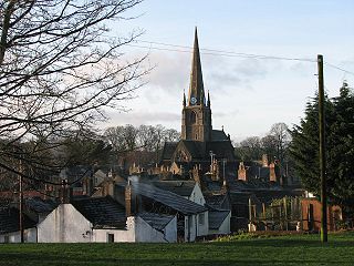
Chesterfield is a market town in the Borough of Chesterfield, Derbyshire, England. It is 24 miles (39 km) north of Derby and 11 miles (18 km) south of Sheffield at the confluence of the River Rother and River Hipper. In 2011, the built-up-area subdivision had a population of 88,483, making it the second-largest settlement in Derbyshire, after Derby. The wider borough had a population of 103,801 in 2011. In 2011, the town had a population of 76,753.

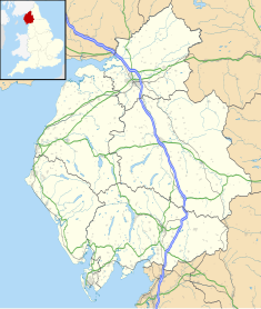
Barrow-in-Furness is a port town and civil parish in the Westmorland and Furness district, in the ceremonial county of Cumbria, England. Historically in Lancashire, it was incorporated as a municipal borough in 1867 and merged with Dalton-in-Furness Urban District in 1974 to form the Borough of Barrow-in-Furness. In 2023, the borough merged with Eden and South Lakeland districts to form a new unitary authority: Westmorland and Furness. At the tip of the Furness peninsula, close to the Lake District, it is bordered by Morecambe Bay, the Duddon Estuary and the Irish Sea. In 2021, Barrow's population was 55,489, making it the second largest urban area in Cumbria after Carlisle, and the largest in the Westmorland and Furness unitary authority.
Cockermouth is a market town and civil parish in the Cumberland unitary area of Cumbria, England, so named because it is at the confluence of the River Cocker as it flows into the River Derwent. The mid-2010 census estimates state that Cockermouth has a population of 8,204, increasing to 8,761 at the 2011 Census.

Bushey is a town in the Hertsmere borough of Hertfordshire in the East of England. It had a population of 25,328 in the 2011 census, rising to 28,416 in the 2021 census, an increase of 12.19%. This makes Bushey the second most populated town in Hertsmere. Bushey Heath is a large neighbourhood south east of Bushey on the boundary with the London Borough of Harrow reaching elevations of 165 metres (541 ft) above sea level.

Barrow-in-Furness was a local government district with borough status in Cumbria, England. It was named after its main town, Barrow-in-Furness. Other settlements included Dalton-in-Furness and Askam-in-Furness. It was the smallest district in Cumbria, but the most densely populated, with 924 people per square kilometre. The population was 71,980 in 2001, reducing to 69,087 at the 2011 Census.

Dalton-in-Furness is a town and former civil parish, now in the parish of Dalton Town with Newton, in the Westmorland and Furness district, in the ceremonial county of Cumbria, England. In 2011 it had a population of 7,827. It is located 4 miles (6 km) north east of Barrow-in-Furness.

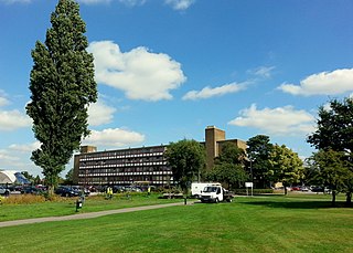
Warwickshire County Council is the county council that governs the non-metropolitan county of Warwickshire in England. Its headquarters are at Shire Hall in the centre of Warwick, the county town. The council's principal functions are county roads and rights of way, social services, education and libraries, but it also provides numerous other local government services in its area.

Coxlodge is an area situated between Fawdon, Gosforth and Kenton in Newcastle upon Tyne, in the county of Tyne and Wear, England. Until 1974 it was in Northumberland.

The town of Aylesbury formed a local government district in Buckinghamshire, England from 1849 to 1974. It was administered as a local board district from 1849 to 1894, as an urban district from 1894 to 1916, and as a municipal borough from 1917 until its abolition in 1974.

Wakefield Council, formally the City of Wakefield Metropolitan District Council, is the local authority of the City of Wakefield in West Yorkshire, England. Wakefield is a metropolitan borough with city status. The council and provides a full range of local government services including Council Tax billing, libraries, social services, town planning, waste collection and disposal, and it is a local education authority. Wakefield is divided into 21 wards, electing 63 councillors. A third of the council is elected for three of every four years.
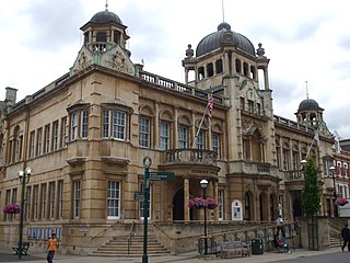
Redbridge Town Hall is a municipal building in High Road, Ilford, London. The town hall, which is the headquarters of Redbridge London Borough Council, is a Grade II listed building.

Wokingham Town Hall is a municipal building in Wokingham, Berkshire, England. The building is the meeting place of Wokingham Town Council and is a Grade II* listed building.
Aylesbury Town Hall is a name which has been used for two different buildings in Aylesbury, Buckinghamshire, England. Since 2007 the name has been used for an office building at 5 Church Street, which serves as the headquarters of Aylesbury Town Council. The name was also formerly used for a complex of buildings which had been built in 1865 as a corn exchange in Market Square, and which served as the offices and meeting place of the local council from 1901 to 1968. The majority of the old town hall was demolished shortly afterwards, leaving only the entrance archway facing Market Square still standing, now called Town Hall Arches. This remaining part of the old town hall is a Grade II* listed building as part of the range of civic buildings on the southern side of Market Square including the old County Hall.
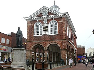
Tamworth Town Hall is a municipal building in Market Street, Tamworth, Staffordshire, England. The town hall, which is the meeting place of Tamworth Borough Council is a Grade II* listed building.

The Borough Hall is a municipal building in Eastgate Street, Stafford, Staffordshire, England. The borough hall, which formed the headquarters of Stafford Borough Council, is a Grade II listed building.

Willenhall Library, formerly Willenhall Town Hall, is a municipal building in Walsall Street in Willenhall, West Midlands, England. The building, which was the headquarters of Willenhall Urban District Council, is a locally listed building.

Tring Market House is a municipal building in the High Street, Tring, Hertfordshire, England. The structure, which is the meeting place of Tring Town Council, is a Grade II listed building.

Minehead Town Hall is a municipal building in The Parade, Minehead, Somerset, England. The structure, which is the meeting place of Minehead Town Council, is a Grade II listed building.
Scunthorpe Civic Centre, also known as Pittwood House, is a municipal building in Ashby Road in Scunthorpe, a town in Lincolnshire in England. The building served as the headquarters of Scunthorpe Municipal Borough Council and later of North Lincolnshire Council, but is now used as a university campus. It is a Grade II listed building.