
Barrow-in-Furness is a port town in Westmorland and Furness, Cumbria, England. Historically in Lancashire, it was incorporated as a municipal borough in 1867 and merged with Dalton-in-Furness Urban District in 1974 to form the Borough of Barrow-in-Furness. In 2023 the borough merged with Eden and South Lakeland districts to form a new unitary authority; Westmorland and Furness. At the tip of the Furness peninsula, close to the Lake District, it is bordered by Morecambe Bay, the Duddon Estuary and the Irish Sea. In 2011, Barrow's population was 56,745, making it the second largest urban area in Cumbria after Carlisle, and the largest in Westmorland and Furness. Natives of Barrow, as well as the local dialect, are known as Barrovian.

Barrow-in-Furness was a local government district with borough status in Cumbria, England. It is named after its main town, Barrow-in-Furness. Other settlements include Dalton-in-Furness and Askam-in-Furness. It is the smallest district in the county, but is the most densely populated, with 924 people per square kilometre. The population was 71,980 in 2001, reducing to 69,087 at the 2011 Census.
Barrow-in-Furness Borough Council in Cumbria, England is elected every 4 years. This was changed in 2011 from the previous situation where one third of the council was elected each year, followed by one year where there was an election to Cumbria County Council instead.
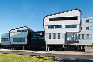
Furness College is a college of further education in Barrow-in-Furness, Cumbria. It provides a wide range of A levels, vocational education and skills training to over 16s, notably working with BAE Systems to train apprentices for their shipyard in Barrow. The college also offers courses for adults, and runs HNDs and other higher education programmes including foundation degrees, degrees and master's degrees, for which it achieved Teaching Excellence Framework silver status in June 2017. It is the only college in Barrow and the largest further education college in Cumbria. On 1 August 2016, Furness College merged with Barrow Sixth Form College.
Capita Property and Infrastructure is a UK multidisciplinary consultancy operating in the building design, civil engineering, environment, management and transport sectors, part of the Capita Group. They employ around 4,500 staff in 50 offices, across the UK and Ireland.

Central Barrow refers both to the town centre of Barrow-in-Furness, Cumbria, England and to the electoral ward that roughly covers the eastern part of that town centre. In 2001 5,584 lived in the Central ward. The population density was 55.96 per hectare, which was well above the local average of 9.24, and England average, 3.77. The population of Central ward had reduced to 4,583 at the 2011 Census.
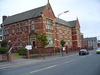
The Higher Grade School building in Barrow-in-Furness, Cumbria, England is Grade II listed and has functioned as a number of educational institutions throughout its long history. From completion until 1930 the building was occupied by the Barrow Higher Grade School.
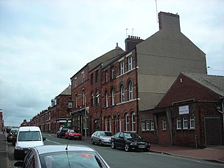
Hindpool is an area and electoral ward of Barrow-in-Furness, Cumbria, England. It is bordered by Barrow Island, Central Barrow, Ormsgill, Parkside and the Walney Channel, the local population stood at 5,851 in 2011. The ward covers the entire western half of the town centre and includes Barrow's main shopping district. Other local landmarks include the Furness College Channelside campus, the Dock Museum and the Main Public Library. Hindpool is also home to two stadia - Barrow Raiders' Craven Park and Barrow A.F.C.'s Holker Street.

The 2002 Barrow-in-Furness Legionnaires' disease outbreak was a fatal outbreak of Legionellosis which occurred in Barrow-in-Furness, Cumbria, England. It was and still remains among the worst such outbreaks in history.

Newbarns is an area and electoral ward of Barrow-in-Furness, Cumbria, England. It is bordered by Hawcoat, Parkside, Risedale and Roose, the local population stood at 5,515 in 2001, decreasing to 5,487 at the 2011 Census.

Abbey Road is the principal north to south arterial road through Barrow-in-Furness, Cumbria, England.
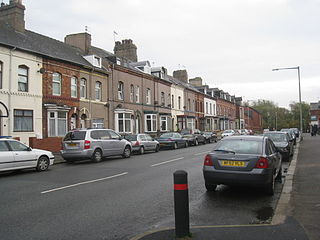
Parkside is an area and electoral ward of Barrow-in-Furness, Cumbria, England. It is bordered by Hindpool, Ormsgill, Hawcoat, Newbarns and Risedale and had a population of 5,742 in 2001, reducing to 5,584 at the 2011 Census. It is one of the town's most centralised wards and contains Barrow's main park, as well as the newly established Furness Academy.
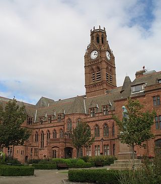
Barrow-in-Furness Town Hall is a Gothic Revival style municipal building in Barrow-in-Furness, Cumbria, England. The building, which served as the headquarters of the former Barrow Borough Council, lies within a Conservation Area with Grade II* listed status.

Craven House is a large office building in Barrow-in-Furness, Cumbria, England located on Michaelson Road close to the eponymous bridge. Constructed in the 1960s the building is noted for its length of roughly 90 m (300 ft) and consists of seven floors making it one of the tallest storied buildings in the town. The gross floor area stands at around 8,100 square metres (87,000 sq ft). Craven House is owned by the Department of Work and Pensions through Barrow Borough Council and currently houses the town's principal Jobcentre alongside leasing office space to the headquarters of successful shipping company James Fisher & Sons - the only Barrow based company listed on the London Stock Exchange.

Emlyn Hughes House is a landmark four storey office building located on the intersection of Abbey Road and Holker Street in Barrow-in-Furness, England. It is named after local footballer Emlyn Hughes who captained both Liverpool F.C. and the England national team, a statue of Hughes is also located outside of the building. Emlyn Hughes House replaces the Art Deco Ritz Cinema and was designed by Bowker Sadler architects and built by Capita Symonds for Barrow Borough Council. There was much speculation that the development would become a 'white elephant' because a year after completion in 2008 the whole building remained vacant.
Furness Academy is a secondary school in Barrow-in-Furness, England. It is the fourth academy to have been formed in the county of Cumbria after the closure of Alfred Barrow School, Parkview Community College of Technology and Thorncliffe School in 2009. Having utilised numerous buildings of the former Parkview and Thorncliffe Schools since 2009, a single £22 million building opened in the Parkside area of the town in September 2013.

Barrow-in-Furness Main Public Library is a Grade II listed Beaux-Arts style building located at Ramsden Square, Barrow-in-Furness, England. Operated since 1974 by Cumbria County Council, it is the largest library in the town and the present structure, designed by J A Charles was originally built as a Carnegie library with support from the Carnegie Foundation.
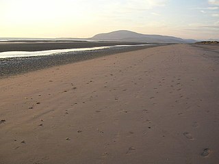
Earnse Bay is a sand and shingle beach located along the western side of Walney Island in the Borough of Barrow-in-Furness, Cumbria, England. Along with Sandy Gap and Biggar Bank, Earnse Bay forms a more or less continuous stretch of eight miles of coastline. The beach offers panoramic views of the Irish Sea, the Isle of Man and the Lake District mountains which have only recently been interrupted by the construction of three large wind farms. Earnse Bay was once planned to be developed into a reputable seaside resort to rival other nearby towns such as Morecambe and Blackpool, however these plans never fully materialised. Despite this, Earnse Bay remains Barrow's most popular beach and is busy with walkers, sunbathers and kitesurfers during the summer months.

Oxford Chambers is a Grade II listed building located on Abbey Road in Barrow-in-Furness, Cumbria, England. Oxford Chambers was constructed in 1875 with the intention of it functioning as a commercial property, however the new town's first higher grades school opened within the building in 1880. The school relocated to a larger premises on Duke Street in 1889. A notable feature of the building is a sign reading 'Central Cigar Depot', it also housed a shop selling office supplies in the late 20th century. Despite this, it is most known for containing the extension of the adjacent Travellers Rest social club. Oxford Chambers lies at the very northern perimeter of the Central Barrow conservation area close to The Duke of Edinburgh Hotel and the neighbouring Cooke's Building.
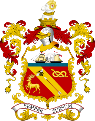
The coat of arms of Barrow-in-Furness was the official symbol of Barrow Borough Council, the governing body of the Borough of Barrow-in-Furness, England. The arms were officially granted on 13 December 1867 to the County Borough of Barrow-in-Furness. Upon the amalgamation of the County Borough and adjacent Dalton-in-Furness Urban District on 16 April 1975 the arms were adopted by the Barrow Borough Council.


