
A swing bridge is a movable bridge that can be rotated horizontally around a vertical axis. It has as its primary structural support a vertical locating pin and support ring, usually at or near to its center of gravity, about which the swing span can then pivot horizontally as shown in the animated illustration to the right.

The BNSF Railway Bridge 5.1, also known as the St. Johns Railroad Bridge or the Willamette River Railroad Bridge, is a through truss railway bridge with a vertical lift that spans the Willamette River in Portland, Oregon, United States. Built by the Spokane, Portland and Seattle Railway (SP&S) and completed in 1908, it was originally a swing-span bridge, and its swing-span section was the longest in the world at the time. However, 81 years later the main span was converted from a swing-type to a vertical-lift type, in order to widen the navigation channel. The lift span is one of the highest and longest in the world. The bridge consists of five sections, with the two sections closest to the bank on each side fixed.

Interstate 195 (I-195) is an auxiliary Interstate Highway running a combined 44.55 miles (71.70 km) in the US states of Rhode Island and Massachusetts. It travels from a junction with I-95 in Providence, Rhode Island, east to a junction with I-495 and Massachusetts Route 25 in Wareham, Massachusetts. It runs east–west and passes through the cities of Fall River, Massachusetts, and New Bedford, Massachusetts. The portion of I-195 in East Providence is also known as the East Providence Expressway.

The Boston and Providence Railroad was a railroad company in the states of Massachusetts and Rhode Island which connected its namesake cities. It opened in two sections in 1834 and 1835 - one of the first rail lines in the United States - with a more direct route into Providence built in 1847. Branches were built to Dedham in 1834, Stoughton in 1845, and North Attleboro in 1871. It was acquired by the Old Colony Railroad in 1888, which in turn was leased by the New Haven Railroad in 1893. The line became the New Haven's primary mainline to Boston; it was realigned in Boston in 1899 during the construction of South Station, and in Pawtucket and Central Falls in 1916 for grade crossing elimination.

The Jamestown Bridge was a cantilever truss bridge that connected Conanicut Island to mainland North Kingstown, Rhode Island, spanning the West passage of Narragansett Bay. The bridge first opened to traffic in 1940, replacing ferry service as the primary connection for the town of Jamestown, situated on Conanicut Island. It was constructed for just over $3 million 1940 USD, which was paid for by tolls until June 28, 1969. With a total length of 6,892 feet, the Jamestown Bridge was the third longest in Rhode Island at the time of its destruction, ranking behind its replacement, the adjacent 7,350-foot Jamestown Verrazzano Bridge, and the 11,248-foot Claiborne Pell Newport Bridge connecting Conanicut Island to Aquidneck Island and Newport. The Jamestown Bridge was closed to vehicular traffic on October 8, 1992, and its main span was destroyed through a controlled demolition on April 18, 2006.

The Henderson Bridge is a bridge in Rhode Island which spans the Seekonk River, and connects the East Side neighborhood of Providence with the Watchemoket and Phillipsdale neighborhoods of East Providence. After a major reconstruction, the bridge reopened to automobile traffic in phases from November 16 to 20, 2023. A new cycle path opened on November 27. A few weeks later, it was used as a detour during the emergency closure of the westbound half of the parallel Washington Bridge.

The East Side Railroad Tunnel is a former railroad tunnel that runs underneath the East Side of Providence, Rhode Island. The tunnel runs 5,080 feet (1,550 m), under College Hill, from Gano Street to just west of Benefit Street. It was opened on November 16, 1908, at a cost of $2 million. All rail service ceased through the tunnel in 1976 and has been abandoned since.

The Seekonk River is a tidal extension of the Providence River in the U.S. state of Rhode Island. It flows approximately 5 km (3 mi). The name may be derived from an Algonquian word for skunk or for black goose. The river is home to the Brown University men's rowing team, India Point Park, Blackstone Park Conservation District, Crook Point Bascule Bridge, Narragansett Boat Club, Swan Point Cemetery, and the Bucklin Point waste-water treatment facility. The River is listed by the Rhode Island Department of Environmental Management as an impaired waterway.

The Quincy Rail Bridge is a truss bridge that carries a rail line across the Mississippi River between West Quincy, Missouri, and Quincy, Illinois, USA. It was originally constructed in 1868 for the Chicago, Burlington and Quincy Railroad, a predecessor of BNSF Railway.
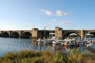
The Washington Bridge is a series of three bridges carrying Interstate 195, US Route 6, US Route 44, and U.S. Route 1A over the Seekonk River connecting India Point in Providence to Watchemoket Square in East Providence, Rhode Island. The historic portion of the bridge dating to 1930 serves as the pedestrian crossing, and bike link to the East Bay Bike Path. The pedestrian span is also a part of the Washington-Rochambeau National Historic Trail. As of December 11, 2023, the westbound bridge is closed due to critical safety issues. On March 14, 2024, Governor Dan McKee announced that the westbound bridge cannot be repaired. It will remain closed for at least two years so it may be replaced.

The East Junction Branch is a rail line in Rhode Island and Massachusetts, in the United States. Originally built by the Boston and Providence Railroad (B&P) in 1835, the line connects Attleboro, Massachusetts, and East Providence, Rhode Island via Seekonk, Massachusetts. As built, the line continued across the Seekonk River to Providence via the India Point Railroad Bridge; this connection was removed during the 1970s. The East Junction Branch meets the Northeast Corridor in Attleboro at a point known as East Junction, and ends at a connection to the East Providence Branch in East Providence. CSX Transportation operates freight service on the branch in Attleboro, while the Providence and Worcester Railroad (P&W) operates freight service in East Providence and across the state line into Seekonk. The line is owned by the P&W in Rhode Island, and by the Massachusetts Bay Transportation Authority in Massachusetts.
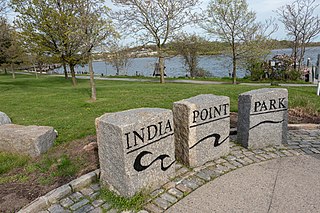
India Point Park is a park in the Fox Point neighborhood of Providence, Rhode Island at the confluence of the Seekonk River and Providence River. The park takes its name from the maritime activity connecting Providence with the East and West Indies. The East Bay Bike Path begins at the eastern end of the park, and crosses over the Washington Bridge before heading to Watchemoket Square in East Providence and continuing on to the Bristol waterfront north of the Mount Hope Bridge. The park is also a part of the Washington–Rochambeau Revolutionary Route.

The Providence River is a tidal river in the U.S. state of Rhode Island. It flows approximately 8 miles (13 km). There are no dams along the river's length, although the Fox Point Hurricane Barrier is located south of downtown to protect the city of Providence from damaging tidal floods.

The East Bay Bike Path is a 14.5-mile (23.3 km) paved rail trail in Rhode Island. The path originates in Providence and India Point Park, crosses the Seekonk River via the George Redman Linear Park and the Washington Bridge, and continues southeast to Bristol along the shoreline of Narragansett Bay. The path passes through the city of East Providence, the hamlet of Riverside, and the towns of Barrington and Warren. It is part of the East Coast Greenway, a 3,000-mile system of trails connecting the Canada–US border in Maine to Key West, as well as provides access to Haines State Park, Brickyard Pond (Barrington), and Colt State Park.
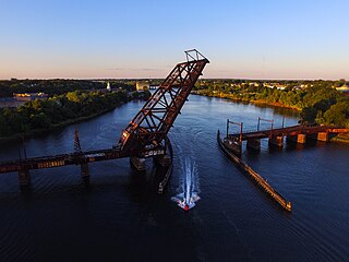
The Sakonnet River rail bridge was a swing bridge that spanned the Sakonnet River between Portsmouth and Tiverton, Rhode Island, and provided the only rail link between Aquidneck Island and the mainland. It was closed in 1988 and removed in 2006–07
The Boston and Providence Railroad Bridge in East Providence is a railroad bridge on the East Junction Branch spanning Ten Mile River. A portion of the bridge also spans Roger Williams Avenue. The bridge was built in 1884 by the Boston and Providence Railroad, replacing an earlier structure on the line. The bridge abutments are faced in coursed ashlar stone, with brick-faced segmental-arch tunnels piercing them. The main span of the bridge consists of two Warren trusses resting on the abutments and a central pier in the Ten Mile River. The bridge formerly carried two tracks, but has been reduced to one.
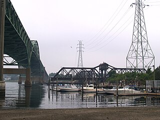
The Crook Point Bascule Bridge is a defunct Scherzer rolling lift railway bridge which spans the Seekonk River, connecting the city of Providence, Rhode Island, to the city of East Providence. Stuck in the open position since its abandonment in 1976, it is known to nearby residents as the "Stuck-Up Bridge" and has become somewhat of a local icon of urban decay. In 2022, the Providence Journal described the bridge as "a T-shirt-ready symbol of Providence's quirky evolution from industrial to creative hub."

The Providence, Warren and Bristol Railroad was a railroad in the state of Rhode Island that connected the city of Providence with Bristol, Rhode Island. The company was formed in 1854 by merging the Providence, Warren and Bristol Railroad Companies of Massachusetts and Rhode Island. The 14.1-mile line itself was completed on July 12, 1855.

Green Jacket Shoal is a 33-acre (13 ha) shoal and ship graveyard in Providence River, between the cities of East Providence and Providence, Rhode Island, United States. It contains a large amount of debris from a century of abandoned and wrecked ships, destroyed docks, pilings, and other remnants of the area's industrial past. India Point, on the Providence side, was the city's first port, which remained active from 1680 until the Great Depression in the early 20th century. Bold Point, on the East Providence side, was home to a dry dock and other maritime businesses.

The East Providence Branch is a railroad line in Rhode Island and Massachusetts, in the United States. It connects Valley Falls, Rhode Island, to East Providence, Rhode Island, via South Attleboro, Massachusetts, and Pawtucket, Rhode Island. The branch was originally built by the Providence and Worcester Railroad (P&W) in 1874, connecting its main line to a coal dock in East Providence, and was 7 miles (11 km) in length. At East Providence, the branch also met the East Junction Branch of the Boston and Providence Railroad and the mainline of the Providence, Warren and Bristol Railroad. Built as a single-track railroad with bridges and the right-of-way prepared for future double-tracking, the line was fully double-tracked from 1892 to 1895; the second track was eventually removed.


