Seekonk, Massachusetts

Last updated

Seekonk, Massachusetts
Seekonk MA Town Hall.jpg
Seekonk Town Hall
Flag of Seekonk, Massachusetts.gif
Seal of Seekonk, Massachusetts.png
Bristol County Massachusetts incorporated and unincorporated areas Seekonk highlighted.svg
Location in Bristol County in Massachusetts
Coordinates: 41°48′30″N71°20′15″W / 41.80833°N 71.33750°W / 41.80833; -71.33750
Country United States
State Massachusetts
County Bristol
Settled1636
Incorporated1812
Government
  Type Open town meeting
  AdministratorShawn E. Cadime
  Selectmen
  • Justin Sullivan, Chairman;
  • Christopher Zorra, Vice Chairman;
  • Adam Petronio, Clerk;
  • David Andrade
  • Michael P. Healy
Area
  Total18.32 sq mi (47.7 km2)
  Land18.22 sq mi (47.4 km2)
  Water0.10 sq mi (0.3 km2)
Elevation
50 ft (15 m)
Population
 (2020)
  Total15,531
  Density850/sq mi (330/km2)
Time zone UTC-5 (Eastern)
  Summer (DST) UTC-4 (Eastern)
ZIP code
02771
Area code 508 / 774
FIPS code 25-60645
GNIS feature ID0618286
Website www.seekonk-ma.gov

Seekonk is a town in Bristol County, Massachusetts, United States, on the Massachusetts border with Rhode Island. It was incorporated in 1812 from the western half of Rehoboth. The population was 15,531 at the 2020 census. [1] In 1862, under a U.S. Supreme Court decision resolving a longstanding border dispute between Massachusetts and Rhode Island, a portion of Tiverton Rhode Island was awarded to Massachusetts to become part of Fall River, while 2/3 of Seekonk (now eastern Pawtucket and East Providence) was awarded to Rhode Island. [2] [3]

Contents


History

Early years

The earliest known inhabitants of Seekonk were Native Americans from the Wampanoag Tribe. The name Wampanoag means People of the Morning Light. This name refers to the geographical area of the tribe. Living in the East they would be the first people to greet the sun each morning. The area now known as Seekonk and Rehoboth provided agricultural and water resources with abundant food supplies. During the warm summer months the Natives spent time near the rivers and oceans in what is now Southeastern Massachusetts. In the winter months the Natives lived inland, including several locations in Seekonk. At one time there were three Native American villages in the area we now call Seekonk.

There have been many spellings of the name Seekonk. Some of the various spellings include Seconch, Sink Hunk, Secquncke, Seaconke, and Squannakonk. The symbol of the goose in flight is used on the Town Seal.

Chief Massasoit

The chief of the Wampanoags at the time the colonists settled in Southeastern Massachusetts was known as Massasoit Ossamequin and had been seriously affected by a plague just prior to the arrival of the Pilgrims at Plymouth. A large number of Wampanoag Indians had been killed by this illness. Most historians believe this plague to have been yellow fever.

Massasoit decided to make a peace treaty with the new immigrants for a number of reasons. Perhaps the most important factor was that the Wampanoags were fearful of being overtaken by the Narragansett Indians who lived nearby. Ossamequin believed an alliance with the English would help to secure the safety of his people.

In 1641, the local Native Americans had granted a large part of modern-day Seekonk to purchasers from Hingham, including Edward Gilman Sr., Joseph Peck, John Leavitt and others. [4] In 1653 Ossamequin and his son Wamsetto, also known as Alexander to the English, signed a deed granting the land that is now Seekonk and the surrounding communities to Thomas Willitt, Myles Standish and Josiah Winslow.

The Wampanoags were paid 35 pounds sterling by the English settlers, for instance, for the sale to Willitt, Standish and Winslow.

Three of the earliest English men to settle in the area now known as Seekonk and Providence were William Blackstone, Roger Williams and Samuel Newman. These men and their followers proved it was possible to provide a living away from the coastal areas. This allowed groups of individuals to separate themselves from Puritan control. In turn this led to a greater diversity of culture and religious and philosophical freedom. It was only by forming alliances with the Native Americans in both the Wampanoag and Narragansett tribes that these early settlements were able to flourish.

King Philip's War

Massasoit lived until he was 80 years old. While he lived, his people and the settlers lived in relative peace. He was followed in power by his son Wamsetto, also known as Alexander. This chief died shortly after his father and was replaced by his brother Metacomet, also known as King Philip.

In 1675, King Philip's War began and both sides saw this as an opportunity to claim the land for their people and their way of life. Metacomet and his people ultimately lost the war, and the chief was killed by a mixed group of English and Indian fighters led by Benjamin Church. He was beheaded and his head stayed on public display on a pole in Plymouth for 25 years.

Incorporation to today

For the next 200 years the area we now call Seekonk was primarily a farming community. Accounts of Town Meetings during these years communicate just how contentious deciding what was best for this area could be. Boundary disputes were common and the land that is now Rehoboth, East Providence, Pawtucket and Seekonk was claimed by both Rhode Island and Massachusetts. In 1812 the border disputes were settled by the courts and the present town of Seekonk was incorporated. Two industrial villages developed to supplement the agricultural economy, with such businesses as the Rumford Chemical Works, but what had been the industrial area of the town in the late-18th and early-19th century was lost when East Providence was incorporated in 1862 taking half of the town's territory, two-thirds of its valuation and more than two-thirds of its population. The town remained basically agricultural into the 20th century, although the Kent Manufacturing Company did make tennis racquets and croquet sets on the upper reaches of the Tenmile River. With the opening of the Providence and Taunton street railway in 1891, Seekonk became increasingly a residential suburb of Providence.

Very few farms still exist in Seekonk. Developers have turned the farms into housing divisions and Seekonk is used largely as a suburban home community for people who work in the Rhode Island and Boston areas. It is now well known for its retail area along Route 6, which includes a movie multiplex, many different chain stores and restaurants, Seekonk Speedway, a 1/3 mile oval track located along Route 6, as well as Seekonk Grand Prix, with multiple amusement rides and miniature golf. Although there has been a great deal of building in Seekonk since the Wampanoags first lived here one can still see many of the "black" Canada geese which give the town its name.

Geography

Old Grist Mill Pond Old Grist Mill Pond, Seekonk MA.jpg
Old Grist Mill Pond

According to the United States Census Bureau, the town has a total area of 18.4 square miles (48 km2), of which, 18.3 square miles (47 km2) of it is land and 0.1 square miles (0.26 km2) of it is water. The total area is 0.54% water. It is bordered by Rehoboth to the east, Barrington, Rhode Island and Swansea to the south, East Providence and Pawtucket, Rhode Island to the west, and Attleboro to the north. Much of the population is concentrated in two areas; one, the Lebanon Mills and Perrins Crossing neighborhoods in the north, and the other, the southern neighborhoods of Luthers Corners and South Seekonk, mostly located between Interstate 195 and Route 44. Seekonk is just five miles (8 km) east of Providence, Rhode Island, and is 48 miles (77 km) southwest of Boston.

The town has three golf courses Ledgemont Country Club (private), Pawtucket Country Club (private) and Firefly Golf Course (public). Slater Memorial Park in Pawtucket lies just over the Seekonk line, next to Pawtucket Country Club. The Town lies within two watershed areas, the Ten Mile River Watershed and the Narragansett Bay Watershed.

Transportation

The town can be accessed through one interstate, I-195, as well as Route 6, Route 44, Route 152 and Route 114A. Seekonk has its own exit on I-195, Massachusetts Exit 1, Route 114A, which provides easy access to Route 6 to the south and Route 44 to the north. Route 152, while not connected to any other state route in town, is a major route running between East Providence and Attleboro.

From the south end of town, access can be had by the Rhode Island Public Transit Authority (RIPTA) stop on Commerce Way.

From the north end of town, easy access can be had to Interstate 95 and the South Attleboro stop of the MBTA's commuter line between Providence and Boston. That end of town is also served by a regional transit authority, the Greater Attleboro Taunton Regional Transit Authority (GATRA). The town's nearest airport is T.F. Green Airport in Warwick, Rhode Island, near Providence 13 miles (21 km) away. Logan International Airport is the nearest international airport, 50 miles (80 km) away in Boston.

Demographics

Historical population
YearPop.±%
1850 2,243    
1860 2,662+18.7%
1870 1,021−61.6%
1880 1,227+20.2%
1890 1,317+7.3%
1900 1,673+27.0%
1910 2,397+43.3%
1920 2,898+20.9%
1930 4,762+64.3%
1940 4,912+3.1%
1950 6,104+24.3%
1960 8,399+37.6%
1970 11,116+32.3%
1980 12,269+10.4%
1990 13,046+6.3%
2000 13,425+2.9%
2010 13,722+2.2%
2020 15,531+13.2%
202215,649+0.8%

Source: United States census records and Population Estimates Program data. [5] [6] [7] [8] [9] [10] [11] [12] [13] [14] [15]

As of the census [16] of 2000, there were 13,425 people, 4,843 households, and 3,874 families residing in the town. The population density was 733.0 inhabitants per square mile (283.0/km2). There were 4,947 housing units at an average density of 270.1 per square mile (104.3/km2). The racial makeup of the town was 96.57% White, 0.52% African American, 0.28% Native American, 0.95% Asian, 0.00% Pacific Islander, 0.51% from other races, and 1.18% from two or more races. 0.74% of the population were Hispanic or Latino of any race.

There were 4,843 households, out of which 35.7% had children under the age of 18 living with them, 67.6% were married couples living together, 9.5% had a female householder with no husband present, and 20.0% were non-families. 16.8% of all households were made up of individuals, and 8.8% had someone living alone who was 65 years of age or older. The average household size was 2.77 and the average family size was 3.12.

In the town, the population was spread out, with 25.3% under the age of 18, 6.1% from 18 to 24, 28.7% from 25 to 44, 26.4% from 45 to 64, and 13.5% who were 65 years of age or older. The median age was 40 years. For every 100 females, there were 94.3 males. For every 100 females age 18 and over, there were 92.6 males.

The median income for a household in the town was $56,364, and the median income for a family was $62,361. Males had a median income of $42,404 versus $29,782 for females. The per capita income for the town was $24,058. 2.4% of the population and 1.7% of families were below the poverty line. 3.0% of those under the age of 18 and 2.2% of those 65 and older were living below the poverty line.

In the year 2000 the population was 13,425, with 6,517 males (48.5%) and 6,908 females (51.5%). Popular ancestries of the population include Portuguese (22.0%), Irish (21.4%), English (16.7%), French (14.4%), Italian (11.9%) and French Canadian (6.4%).

Government

On the state level, Seekonk is part of the Fourth Bristol state representative district, including Rehoboth and parts of Norton and Swansea, and the Bristol and Norton state senatorial district, including part of the city of Attleboro and all or parts of the towns of Dover, Foxborough, Mansfield, Medfield, Norton, Rehoboth, Sharon and Walpole. Seekonk's state representative is Steve Howitt representing the 4th Bristol District. Seekonk is patrolled by Troop D (Southeast District), 4th Barracks (located in Middleborough) of the Massachusetts State Police. On the national level, the town is part of Massachusetts Congressional District 4, which is represented by Jake Auchincloss. The state's Senior (Class I) Senator is Elizabeth Warren, and the state's Junior (Class II) Senator, is Ed Markey.

Seekonk is governed by an Open Town Meeting led by a Board of Selectmen. The town has a central police station on Route 44, and a central post office at the corner of Routes 44 and 114A. The Seekonk Public Library is located near the center of town along Route 152. The town also has a branch of the YMCA.

Seekonk's current board of selectmen are: Justin Sullivan (Chairman), Christopher Zorra (Vice Chairman), Adam Petronio (Clerk), David J. Andrade, and Michael P. Healy. The current Town Administrator is Shawn E. Cadime.

Fire Department

The Seekonk Fire Department provides all fire and paramedic services to the town. The Department responded to 3,157 calls for emergency services in fiscal year 2017. There are 38 career firefighters, consisting of 4 groups of 9 firefighters. 2 Monday–Friday daytime Captains and Chief of the Department, Sandra J. Lowery.

The Fire Department operates the following stations and apparatus.

StationDesig.LocationStaffingYear Built
Seekonk Fire Department Company No. 11170 County StreetNot staffed1942
Richard C. Banna Memorial Fire Station230 Pine StreetCareer-staffing of 1 engine and ALS rescue2014
Seekonk Public Safety Headquarters3500 Taunton AvenueFull-time career personnel2005

Education

Seekonk has its own public school system, with four active schools. The town has two elementary schools: Mildred H. Aitken Elementary School (serving the north and central parts of town), and George R. Martin Elementary School (serving the south). North Elementary School closed during the summer of 2006 after 95 years of service due to budget cuts. Dr. Kevin M. Hurley Middle School, named for a popular town educator, is located along Route 152 and serves the town's 6th through 8th grade population. Seekonk High School is located near the center of town. Seekonk athletics teams are nicknamed the "Warriors," and its school colors are Columbia blue, navy blue, and white though traditionally the school colors are Columbia blue and white. The school uses the "spear" logo made famous by Florida State University and, formerly, the Washington Redskins. Seekonk is the southernmost member of the Tri-County Regional Vocational Technical High School district, which is centered in Franklin. High school students may also choose to attend Bristol County Agricultural High School in Dighton, or any of a number of religious schools in the surrounding communities (the closest school in-state being Bishop Feehan High School in Attleboro).

Notable people

See also

Related Research Articles

<span class="mw-page-title-main">Bristol County, Massachusetts</span> County in Massachusetts, United States

Bristol County is a county in the Commonwealth of Massachusetts. As of the 2020 census, the population was 579,200. The shire town is Taunton. Some governmental functions are performed by the Commonwealth of Massachusetts, others by the county, and others by local towns and cities.

<span class="mw-page-title-main">Providence County, Rhode Island</span> County in Rhode Island, United States

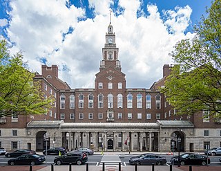
Providence County is the most populous county in the U.S. state of Rhode Island. As of the 2020 census, the county's population was 660,741, or 60.2% of the state's population. Providence County contains the city of Providence, the state capital of Rhode Island and the county's most populous city, with an estimated 190,934 residents in 2020. Providence County is included in the Providence-Warwick, RI-MA Metropolitan Statistical Area, which in turn constitutes a portion of the greater Boston-Worcester-Providence, MA-RI-NH-CT Combined Statistical Area. As of 2010, the center of population in Rhode Island is located in Providence County, in the city of Cranston.

<span class="mw-page-title-main">Attleboro, Massachusetts</span> City in Massachusetts, United States

Attleboro is a city in Bristol County, Massachusetts, United States. It was once known as "The Jewelry Capital of the World" for its many jewelry manufacturers. According to the 2020 census, Attleboro had a population of 46,461.

<span class="mw-page-title-main">Mansfield, Massachusetts</span> Town in Massachusetts, United States

Mansfield is a town in Bristol County, Massachusetts, United States. As of the United States 2020 Census, the town population is 23,860. Mansfield is in the south-southwest suburbs of Boston and is also close to Providence, Rhode Island. The village of Mansfield Center is located in the town. The town is twinned with Mansfield in Nottinghamshire, England.

<span class="mw-page-title-main">North Attleborough, Massachusetts</span> City in Massachusetts, United States

North Attleborough, alternatively spelled North Attleboro, is a city in Bristol County, Massachusetts, United States. The population was 30,834 at the 2020 United States Census.

<span class="mw-page-title-main">Raynham, Massachusetts</span> Town in Massachusetts, United States

Raynham is a town in Bristol County, Massachusetts, United States, located approximately 32 miles (51 km) south of Boston and 22 miles (35 km) northeast of Providence, Rhode Island. The population was 15,082 at the 2020 census. It has one village, Raynham Center.

<span class="mw-page-title-main">Rehoboth, Massachusetts</span> Town in Massachusetts, United States

Rehoboth is a historic town in Bristol County, Massachusetts. Established in 1643, Rehoboth is one of the oldest towns in Massachusetts. The population was 12,502 at the 2020 census. Rehoboth is a mostly rural community with many historic sites, including 53 historic cemeteries.

<span class="mw-page-title-main">Swansea, Massachusetts</span> Town in Massachusetts, United States

Swansea is a town in Bristol County in southeastern Massachusetts. It is located at the mouth of the Taunton River, just west of Fall River, 47 miles (76 km) south of Boston, and 12 miles (19 km) southeast of Providence, Rhode Island. The population was 17,144 at the 2020 census. The villages of Hortonville, Barneyville and Ocean Grove are located in the town.

<span class="mw-page-title-main">Pawtucket, Rhode Island</span> City in Rhode Island

Pawtucket is a city in Providence County, Rhode Island. The population was 75,604 at the 2020 census, making the city the fourth-largest in the state. Pawtucket borders Providence and East Providence to the south, Central Falls and Lincoln to the north, and North Providence to the west. The city also borders the Massachusetts municipalities of Seekonk and Attleboro.

<span class="mw-page-title-main">Pokanoket</span> Native American village and 17th c. Native American political division

The Pokanoket was the village governed by Massasoit. The term broadened to refer to all peoples and lands governed by Massasoit and his successors, which were part of the Wampanoag people in what is now Rhode Island and Massachusetts.

The Narragansett Council of the Boy Scouts of America serves all of the state of Rhode Island and some of Massachusetts and Connecticut. Its several camps include Camp Yawgoog, Champlin Scout Reservation, and Camp Norse.

<span class="mw-page-title-main">Scouting in Rhode Island</span>

Scouting in Rhode Island has a long history, from the 1910s to the present day, serving thousands of youth in programs that suit the environment in which they live.

<span class="mw-page-title-main">Route 114A (Rhode Island–Massachusetts)</span> Highway in Rhode Island and Massachusetts

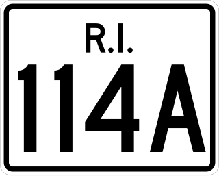
Route 114A is an alternate state route to Rhode Island Route 114, located along the Massachusetts – Rhode Island border in East Providence, RI and Seekonk, MA. The road begins and ends within East Providence in Rhode Island at Route 114. Most of the road, however, is located within Seekonk and designated as Massachusetts Route 114A.

<span class="mw-page-title-main">East Junction Branch</span> Railroad line

The East Junction Branch is a rail line in Rhode Island and Massachusetts, in the United States. Originally built by the Boston and Providence Railroad (B&P) in 1835, the line connects Attleboro, Massachusetts, and East Providence, Rhode Island via Seekonk, Massachusetts. As built, the line continued across the Seekonk River to Providence via the India Point Railroad Bridge; this connection was removed during the 1970s. The East Junction Branch meets the Northeast Corridor in Attleboro at a point known as East Junction, and ends at a connection to the East Providence Branch in East Providence. CSX Transportation operates freight service on the branch in Attleboro, while the Providence and Worcester Railroad (P&W) operates freight service in East Providence and across the state line into Seekonk. The line is owned by the P&W in Rhode Island, and by the Massachusetts Bay Transportation Authority in Massachusetts.

<span class="mw-page-title-main">Route 152 (Rhode Island–Massachusetts)</span> Highway in Rhode Island and Massachusetts

Route 152 is a state highway in the U.S. states of Rhode Island and Massachusetts. The highway begins at U.S. Route 1A and Route 114 in East Providence, Rhode Island. After crossing into Massachusetts, Route 152 runs 14.8821 miles (23.9504 km) through Seekonk, Attleboro, and North Attleboro to US 1 in Plainville.

<span class="mw-page-title-main">Providence metropolitan area</span> Metropolitan Statistical Area in the United States

The Providence metropolitan area is a region extending into eight counties in two states. Its core is in the states of Rhode Island and Massachusetts, and it is the 38th largest metropolitan area in the United States. The largest city in the Providence MSA is Providence, Rhode Island, with an estimated population of 1,622,520, exceeding that of Rhode Island by slightly over 60%. The MSA covers all of Rhode Island and Bristol County, Massachusetts, with an average population density of 2300 per mi2.

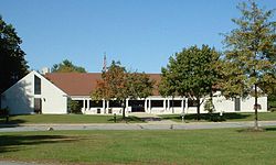
Seekonk High School is a public high school operated by Seekonk Public Schools in Seekonk, Massachusetts, United States. It serves the district's 9–12 student population. The school's mission statement is "All students will achieve their maximum potential by becoming responsible, productive citizens and life-long learners."

<span class="mw-page-title-main">Nathaniel Daggett House</span> Historic house in Rhode Island, United States

See also Daggett House, Slater Park, Pawtucket RI, built about the same time, by Nathaniel's father John.

<span class="mw-page-title-main">Norton, Massachusetts</span> Town in Massachusetts, United States

Norton is a town in Bristol County, Massachusetts, United States, and contains the villages of Norton Center and Chartley. The population was 19,202 at the 2020 census. Home of Wheaton College, Norton hosted the Dell Technologies Championship, a tournament of the PGA Tour held annually on the Labor Day holiday weekend at the TPC Boston golf club until 2018.

The Seaconke Wampanoag Tribe is one of several cultural heritage organizations of individuals who identify as descendants of the Wampanoag people in Rhode Island and Massachusetts. Multiple nonprofit organizations were formed to represent the Seaconke Wampanoag.

References

  1. "Census - Geography Profile: Seekonk town, Bristol County, Massachusetts". United States Census Bureau . Retrieved November 11, 2021.
  2. History of Bristol County
  3. Cady, John Hutchins (1936). Rhode Island Boundaries 1636-1936. Rhode Island Tercentary Commission., pp 1-31.
  4. History of Newfields, New Hampshire, 1638-1911, James Hill Fitts, Nathan Franklin Carter, Concord, 1912
  5. "Total Population (P1), 2010 Census Summary File 1". American FactFinder, All County Subdivisions within Massachusetts. United States Census Bureau. 2010.
  6. "Massachusetts by Place and County Subdivision - GCT-T1. Population Estimates". United States Census Bureau. Retrieved July 12, 2011.
  7. "1990 Census of Population, General Population Characteristics: Massachusetts" (PDF). US Census Bureau. December 1990. Table 76: General Characteristics of Persons, Households, and Families: 1990. 1990 CP-1-23. Retrieved July 12, 2011.
  8. "1980 Census of the Population, Number of Inhabitants: Massachusetts" (PDF). US Census Bureau. December 1981. Table 4. Populations of County Subdivisions: 1960 to 1980. PC80-1-A23. Retrieved July 12, 2011.
  9. "1950 Census of Population" (PDF). Bureau of the Census. 1952. Section 6, Pages 21-10 and 21-11, Massachusetts Table 6. Population of Counties by Minor Civil Divisions: 1930 to 1950. Retrieved July 12, 2011.
  10. "1920 Census of Population" (PDF). Bureau of the Census. Number of Inhabitants, by Counties and Minor Civil Divisions. Pages 21-5 through 21-7. Massachusetts Table 2. Population of Counties by Minor Civil Divisions: 1920, 1910, and 1920. Retrieved July 12, 2011.
  11. "1890 Census of the Population" (PDF). Department of the Interior, Census Office. Pages 179 through 182. Massachusetts Table 5. Population of States and Territories by Minor Civil Divisions: 1880 and 1890. Retrieved July 12, 2011.
  12. "1870 Census of the Population" (PDF). Department of the Interior, Census Office. 1872. Pages 217 through 220. Table IX. Population of Minor Civil Divisions, &c. Massachusetts. Retrieved July 12, 2011.
  13. "1860 Census" (PDF). Department of the Interior, Census Office. 1864. Pages 220 through 226. State of Massachusetts Table No. 3. Populations of Cities, Towns, &c. Retrieved July 12, 2011.
  14. "1850 Census" (PDF). Department of the Interior, Census Office. 1854. Pages 338 through 393. Populations of Cities, Towns, &c. Retrieved July 12, 2011.
  15. "City and Town Population Totals: 2020-2022". United States Census Bureau . Retrieved October 29, 2023.
  16. "U.S. Census website". United States Census Bureau . Retrieved January 31, 2008.
  17. Malinowski, Bill. "A Family's Passion, A Son's Success".
  18. Waldron, John (October 3, 2008). "Is it Time for Johnny Gregorek?". NNHS Track and Cross-Country. Retrieved December 7, 2017.
  19. "Bill Harley". Timpanogos Storytelling. Timpanogos Storytelling Institute. Retrieved December 8, 2017.
  20. "Cristina Nardozzi Biography". Celebrity photos, biographies and more. Retrieved December 7, 2017.
  21. Gobis, Peter (August 10, 2018). "Seekonk's Pina siblings to swim for Cape Verde at 2020 Olympics". The Sun Chronicle. Retrieved September 22, 2018.
  22. "Meet Pina, the Cape Verdean Student in the U.S Leading the African Nation's First-ever Olympic Swim Team". Jetheights Services. HowAfrica. September 18, 2018. Retrieved September 22, 2018.