Norton Center, Massachusetts

Last updated

Norton Center, Massachusetts
Norton Town Common.jpg
Norton Town Common
Bristol County Massachusetts incorporated and unincorporated areas Norton Center highlighted.svg
Location in Bristol County in Massachusetts
Coordinates: 41°58′11″N71°11′1″W / 41.96972°N 71.18361°W / 41.96972; -71.18361
Country United States
State Massachusetts
County Bristol
Town Norton
Area
[1]
  Total1.80 sq mi (4.67 km2)
  Land1.70 sq mi (4.39 km2)
  Water0.10 sq mi (0.27 km2)
Population
 (2020)
  Total2,677
  Density1,577.49/sq mi (609.10/km2)
Time zone UTC-5 (Eastern (EST))
  Summer (DST) UTC-4 (EDT)
FIPS code 25-50005

Norton Center is a census-designated place (CDP) in the town of Norton in Bristol County, Massachusetts, United States. The population was 2,671 at the 2010 census. [2]

Contents

Geography

Norton Center is located at 41°58′11″N71°11′1″W / 41.96972°N 71.18361°W / 41.96972; -71.18361 (41.969851, -71.183657). [3]

According to the United States Census Bureau, the CDP has a total area of 4.7 km2 (1.8 mi2), all land.

Demographics

Historical population
CensusPop.Note
2020 2,677
U.S. Decennial Census [4]

As of the census [5] of 2000, there were 2,618 people, 436 households, and 312 families residing in the CDP. The population density was 555.4/km2 (1,438.6/mi2). There were 442 housing units at an average density of 93.8/km2 (242.9/mi2). The racial makeup of the CDP was 65.66% White, 1.57% African American, 0.27% Native American, 1.45% Asian, 29.37% from other races, and 1.68% from two or more races. Hispanic or Latino of any race were 3.48% of the population.

There were 436 households, out of which 36.0% had children under the age of 18 living with them, 59.6% were married couples living together, 9.4% had a female householder with no husband present, and 28.4% were non-families. 20.6% of all households were made up of individuals, and 4.6% had someone living alone who was 65 years of age or older. The average household size was 2.64 and the average family size was 3.06.

In the CDP, the population was spread out, with 11.2% under the age of 18, 55.6% from 18 to 24, 18.0% from 25 to 44, 12.0% from 45 to 64, and 3.2% who were 65 years of age or older. The median age was 21 years. For every 100 females, there were 73.6 males. For every 100 females age 18 and over, there were 71.0 males.

The median income for a household in the CDP was $66,176, and the median income for a family was $84,624. Males had a median income of $44,609 versus $36,736 for females. The per capita income for the CDP was $16,533. None of the families and 8.8% of the population were below the poverty line. None of those under the age of 18 or those 65 and older were living below the poverty line.

Related Research Articles

<span class="mw-page-title-main">Blue Ridge, Alabama</span> Census-designated place in Alabama, United States

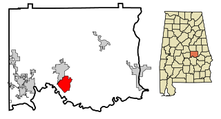
Blue Ridge is an unincorporated community and census-designated place (CDP) in Elmore County, Alabama, United States. At the 2020 census, the population was 1,485. It is part of the Montgomery Metropolitan Statistical Area.

<span class="mw-page-title-main">Bowles, California</span> Census-designated place in California, United States

Bowles is a census-designated place (CDP) in Fresno County, California, United States. The population was 166 at the 2010 census, down from 182 at the 2000 census. Bowles is located 11 miles (18 km) south of downtown Fresno, at an elevation of 279 feet.

<span class="mw-page-title-main">West Puente Valley, California</span> Census-designated place in California, United States

West Puente Valley is an unincorporated community and census-designated place in Los Angeles County, California, USA, northwest of La Puente. The population was 22,636 at the 2010 census, up from 22,589 at the 2000 census. The community is probably named for its location related to the city of La Puente.

<span class="mw-page-title-main">Old Mystic, Connecticut</span> Census-designated place in Connecticut, United States

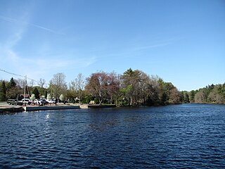
Old Mystic is a village and census-designated place (CDP) located in the town of Groton, Connecticut. The population was 3,554 at the 2010 census.

<span class="mw-page-title-main">North Seekonk, Massachusetts</span> Census-designated place in Massachusetts, United States

North Seekonk is a census-designated place (CDP) in the town of Seekonk in Bristol County, Massachusetts, United States. The population was 2,643 at the 2010 census.

<span class="mw-page-title-main">Ocean Grove, Massachusetts</span> CDP in Massachusetts, United States

Ocean Grove is a census-designated place (CDP) in the town of Swansea in Bristol County, Massachusetts, United States, on the north shore of Mount Hope Bay near the Cole River. The population was 2,811 at the 2010 census, and 2,904 as of the 2020 census.

<span class="mw-page-title-main">Raynham Center, Massachusetts</span> Census-designated place in Massachusetts, United States

Raynham Center is a census-designated place (CDP) in the town of Raynham in Bristol County, Massachusetts, United States. The population was 4,100 at the 2010 census.

<span class="mw-page-title-main">Middleborough Center, Massachusetts</span> Census-designated place in Massachusetts, United States

Middleborough Center is a census-designated place (CDP) in the town of Middleborough in Plymouth County, Massachusetts, United States. The population was 7,319 at the 2010 census.

<span class="mw-page-title-main">East Douglas, Massachusetts</span> CDP in Massachusetts, United States

East Douglas is a census-designated place (CDP) in the town of Douglas in Worcester County, Massachusetts, United States. The population was 2,557 at the 2010 census.

<span class="mw-page-title-main">Quinnesec, Michigan</span> Census-designated place & unincorporated community in Michigan, United States

Quinnesec is an unincorporated community in Dickinson County in the U.S. state of Michigan. It is a census-designated place (CDP) for statistical purposes and has no legally recognized status as a municipality. The population was 1,191 at the 2010 census. It is part of the Iron Mountain, MI–WI Micropolitan Statistical Area.

<span class="mw-page-title-main">Princeton Meadows, New Jersey</span> Populated place in Middlesex County, New Jersey, US

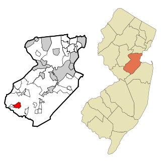
Princeton Meadows is an unincorporated community and census-designated place (CDP) located within Plainsboro Township, in Middlesex County, in the U.S. state of New Jersey. As of the 2010 United States Census, the CDP's population was 13,834.

<span class="mw-page-title-main">Carnot-Moon, Pennsylvania</span> Census-designated place in Pennsylvania, United States

Carnot-Moon is a census-designated place (CDP) in central Moon Township, Allegheny County, Pennsylvania, United States. The population was 13,151 at the 2020 census.

Schlusser pronounced (Skloosher) is a census-designated place (CDP) in North Middleton and Middlesex townships, Cumberland County, Pennsylvania, United States. The population was 5,265 at the 2010 census. It is part of the Harrisburg–Carlisle Metropolitan Statistical Area.

Branchdale is a census-designated place (CDP) in Schuylkill County, Pennsylvania, United States. The population was 436 at the 2000 census.

<span class="mw-page-title-main">Spry, Pennsylvania</span> CDP in Pennsylvania, United States

Spry is a census-designated place (CDP) that is located in York County, Pennsylvania, United States. The population was 4,891 at the time of the 2010 census.

<span class="mw-page-title-main">Cumberland Hill, Rhode Island</span> Census-designated place in Rhode Island, United States

Cumberland Hill is a census-designated place (CDP) in the town of Cumberland, in Providence County, Rhode Island, United States. The population was 7,934 at the 2010 census.

<span class="mw-page-title-main">Harrisville, Rhode Island</span> Census-designated place in Rhode Island, United States

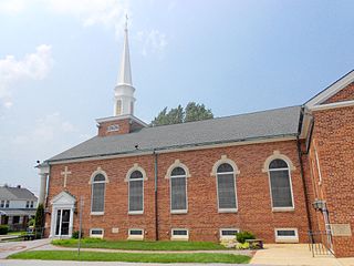
Harrisville is a census-designated place (CDP) and village in the town of Burrillville in Providence County, Rhode Island, United States. The population was 1,605 at the 2010 census. Much of the community composes a historic district listed on the National Register of Historic Places. The village was named after nineteenth century manufacturer Andrew Harris. Previously, the village was named Rhodesville, after Captain William Rhodes, an eighteenth century privateer.

<span class="mw-page-title-main">Lunenburg (CDP), Massachusetts</span> CDP in Massachusetts, United States

Lunenburg is a census-designated place (CDP) in the town of Lunenburg in Worcester County, Massachusetts, United States. The population was 1,760 at the 2010 census.

<span class="mw-page-title-main">Milford (CDP), Massachusetts</span> CDP in Massachusetts, United States

Milford is a census-designated place (CDP) in the town of Milford in Worcester County, Massachusetts, United States. The population was 25,055 at the 2010 census.

<span class="mw-page-title-main">Pleasant Valley (CDP), New York</span> Census-designated place in New York, United States

Pleasant Valley is a census-designated place (CDP) in the southwestern part of the town of Pleasant Valley in Dutchess County, New York, United States. The population was 1,145 at the 2010 census. It is part of the Poughkeepsie–Newburgh–Middletown, NY Metropolitan Statistical Area as well as the larger New York–Newark–Bridgeport, NY-NJ-CT-PA Combined Statistical Area.

References

  1. "2020 U.S. Gazetteer Files". United States Census Bureau. Retrieved May 21, 2022.
  2. "Profile of General Population and Housing Characteristics: 2010 Demographic Profile Data (DP-1): Norton Center CDP, Massachusetts". United States Census Bureau . Retrieved December 7, 2011.
  3. "US Gazetteer files: 2010, 2000, and 1990". United States Census Bureau. February 12, 2011. Retrieved April 23, 2011.
  4. "Census of Population and Housing". Census.gov. Retrieved June 4, 2016.
  5. "U.S. Census website". United States Census Bureau . Retrieved January 31, 2008.