Easton is governed by an elected Select Board. Open Town Meeting acts as the legislative branch of the town. The Select Board chooses a Town Administrator to run the day-to-day operations of the town.
History
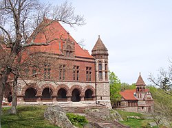
View from The Rockery showing Oakes Ames Memorial hall (left), Ames Free Library (center), and 66 Main Street (right)
Easton was first settled in 1694 and was officially incorporated in 1725.[2]
In 1694, the first settler, Clement Briggs, established his home near the Easton Green. In 1711, the Taunton North Purchase area became Norton, and in 1713, the sixty-nine families settled in Easton and hired Elder William Pratt as their first minister. Prior to the settlers' establishment, the area was occupied by Native Americans as a hunting area and a burial ground. During King Philip's War, Metacom, also known as King Philip, used part of Easton as a headquarters for his troops. There was no legal parish in Easton until 1722, when the East Precinct of Norton was recognized. In 1725, the area was incorporated as the Town of Easton; it was so named because it was formerly called the "East End" of the Taunton North Purchase and was shortened by pronunciation to Easton. During the Revolutionary War, General George Washington stayed at the Benjamin Williams Tavern on Bay Road, which is now the second oldest existing house in Easton, while on his way to negotiate for cannonballs at the old Perry Foundry in Taunton.
Though this school complex was not made by Richardson himself, it was dedicated to him and made in his style:
H.H.Richardson/F.L.Olmsted Intermediate School
In addition, there is a commercial building at 69 Main Street which was designed and built in the nineteenth century by Richardson's office in a Richardsonian style. The Richardson buildings are all located within a compact area designated as the H. H. Richardson Historic District. The area also includes The Rockery, designed by Frederick Law Olmsted, who also landscaped grounds of Oakes Ames Memorial Hall and the Ames Free Library.
Within a few blocks of the H. H. Richardson Historic District is Unity Church, built by the Ames family in 1875, and designed in the Gothic Revival Style by architect and publisher John Ames Mitchell. It includes an ornate oak frieze including sculptures of twenty-two angels playing music, carved by Johannes Kirchmayer (1860–1930), and two notable stained-glass windows, "Angel of Help," and "Figure of Wisdom," both by John LaFarge (1835–1910). "Figure of Wisdom," completed in 1901, is the largest stained-glass work created by LaFarge.[3]
Geography
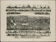
North Easton in 1891
According to the United States Census Bureau, the town has a total area of 29.2 square miles (76km2), of which 28.4 square miles (74km2) is land and 0.7 square miles (1.8km2) (2.54%) is water. The town, in addition to its own smaller town forest, includes part of Borderland State Park at the northwest corner of town, Hockomock Swamp Wildlife Management Area at the southeast corner of town, and all of Wheaton Farm Conservation Area in the southwest. All of the town's waterways are considered part of the Taunton River Watershed area, which in turn is the eastern section of the Narragansett Bay Watershed area.
Easton forms the northeastern corner of Bristol County, where the county intersects with Plymouth County to the east and Norfolk County to the north.
The localities of Easton include Alger's Corner, Daley Corner, Easton Center, Easton Green, Eastondale, Five Corners, Furnace Village, Goward's Corner, Morris Corner, Morse Corner, Pratt's Corner. Although there is no official designation dividing "North Easton" from "South Easton," the terms are colloquially used by older residents of the town even though they have no governmental or legal standing.[4]
Easton is located in eastern Massachusetts. The roughly trapezoidal-shaped town is bordered by Brockton and West Bridgewater to the east, Taunton and Raynham to the south, Norton to either side of its southwest corner, Mansfield to the west, and Sharon and Stoughton to the north.
As of the census[16] of 2000, there were 22,299 people, 7,489 households, and 5,571 families residing in the town. The population density was 784.1 inhabitants per square mile (302.7/km2). There were 7,631 housing units at an average density of 268.3 per square mile (103.6/km2). The racial makeup of the town was 91.94% White, 1.59% African American, 0.04% Native American, 1.39% Asian, 0.01% Pacific Islander, 4.13% from other races, and 0.91% from two or more races. Hispanic or Latino of any race were 1.58% of the population.
There were 7,489 households, out of which 37.4% had children under the age of 18 living with them, 62.3% were married couples living together, 8.9% had a female householder with no husband present, and 25.6% were non-families. 20.7% of all households were made up of individuals, and 6.9% had someone living alone who was 65 years of age or older. The average household size was 2.74 and the average family size was 3.21.
In the town, the population was spread out, with 24.4% under the age of 18, 13.1% from 18 to 24, 28.7% from 25 to 44, 24.3% from 45 to 64, and 9.4% who were 65 years of age or older. The median age was 36 years. For every 100 females, there were 94.6 males. For every 100 females age 18 and over, there were 91.1 males.
The median income for a household in the town was $89,144, and the median income for a family was $112,190. Males had a median income of $51,429 versus $35,912 for females. The per capita income for the town was $40,732. About 0.7% of families and 2.0% of the population were below the poverty line, including 0.6% of those under age 18 and 6.5% of those age 65 or over.
Education
Public schools
Easton's public school system includes one early-elementary school serving kindergarten through second grade: Blanche A. Ames Elementary School; there are two elementary schools serving grades 3–5: Frederick Law Olmsted School and Henry Hobson Richardson School (now considered one school, known as "Richardson-Olmsted.");[17] meanwhile grades 6 through 8 attend Easton Middle School, and high school students attend Oliver Ames High School (OA).[18][19]
Oliver Ames High School's athletic teams' mascot is the tiger. The school colors are orange and black. The OA girls varsity basketball team won the Division II state basketball championship in 2006 and 2010. The Oliver Ames Varsity Baseball team won the Division II State Baseball Championship in June 2007. In November 2007 Oliver Ames girl's varsity soccer team won the Division II state soccer championship. In November 2015 the Oliver Ames boys soccer team won the state championship game. The high school also boasts an impressive music department, complete with a jazz band, marching band, concert band, show choir, concert choir and chamber orchestra. The Oliver Ames Marching Band won the 2008 Division 2 New England championships for USSBA, and placed 5th out of 29 bands competing.
The town is also home to Southeastern Regional Vocational Technical High School, which serves all the bordering towns (except Taunton and Raynham), plus Foxborough. Students may choose to attend Southeastern or Oliver Ames free of charge.
Higher education
Easton is home to Stonehill College, a private, non-profit, coeducational, Roman Catholic, liberal arts college. Their mascot is "Ace" the Skyhawk.
Transportation
Easton is served by the following highways that run through the town: Routes 106, 123 and 138. Additionally, the town is served by two major highways which run just outside its border, Route 24 to the east and Interstate 495 to the south.
Easton receives limited bus service from the Brockton Area Transit Authority, with Route 9 making stops adjacent to Stonehill College and the Easton Industrial Park. Bloom Bus Lines also offers commuter bus service to Taunton and Boston, with a flag stop at the corner of Route 138 and Route 106.[20]
Easton is the site of two proposed MBTA Commuter Rail stations, North Easton and Easton Village, on the Stoughton Branch option of the MBTA's South Coast Rail project. In March 2011, following the release of the U.S. Army Corps of Engineers' Draft Environmental Impact Report, Gov. Deval Patrick's administration and the MBTA announced this alternative as the best option for achieving all the goals of the project. As of 2019, the Easton stations have been moved to Phase 2 of the project, which will not be completed until 2030.[21]
Blanche Ames Ames, Inventor/painter, suffragette, and first president of the Birth Control League of Massachusetts. Maiden name was Ames, married Oakes Ames (below) and kept both names, although no relation until married
Easton is governed by an elected committee of select board members and a town administrator. Easton's "Board of Selectmen" was renamed a Select Board via Town Meeting in 2019.[24]
Easton does not have a daily newspaper, but is served by the Brockton Enterprise, a GateHouse Media company. Easton's last town-specific newspaper, a weekly called the Easton Journal, published its final issue in 2019, combining with three other local weekly newspapers to create a regional weekly called the Journal News Independent (also owned by GateHouse Media).
Easton Community Access Television serves as the public access station for the town, with many town board meetings and school events televised on the channel.[27] Because of Easton's proximity to both Boston and Providence, town residents have access to television networks in both media markets.
Bristol County is a county in the Commonwealth of Massachusetts. As of the 2020 census, the population was 579,200. The shire town is Taunton. Some governmental functions are performed by the Commonwealth of Massachusetts, others by the county, and others by local towns and cities.
Mansfield is a town in Bristol County, Massachusetts, United States. As of the United States 2020 Census, the town population is 23,860. Mansfield is in the south-southwest suburbs of Boston and is also close to Providence, Rhode Island. The village of Mansfield Center is located in the town. The town is twinned with Mansfield in Nottinghamshire, England.
Taunton is a city and county seat of Bristol County, Massachusetts, United States. Taunton is situated on the Taunton River which winds its way through the city on its way to Mount Hope Bay, 10 miles (16 km) to the south. At the 2020 census, the city had a population of 59,408. Shaunna O'Connell is the mayor of Taunton.
Stoughton is a town in Norfolk County, Massachusetts, United States. The population was 29,281 at the 2020 census. The town is located approximately 17 miles (27 km) from Boston, 31 miles (50 km) from Providence, Rhode Island, and 35 miles (56 km) from Cape Cod.
Brockton is a city in Plymouth County, Massachusetts, United States; the population was 105,643 at the 2020 United States census. Along with Plymouth, it is one of the two county seats of Plymouth County. It is the sixth-largest city in Massachusetts and is sometimes referred to as the "City of Champions", due to the success of native boxers Rocky Marciano and Marvin Hagler, as well as its successful Brockton High School sports programs. Two villages within it are Montello and Campello, both of which have MBTA Commuter Rail Stations and post offices. Campello is the smallest neighborhood, but also the most populous. Brockton hosts a baseball team, the Brockton Rox. It is the second-windiest city in the United States, with an average wind speed of 14.3 mph (23.0 km/h).
East Bridgewater is a town in Plymouth County, Massachusetts, United States. The population was 14,440 at the 2020 census. It is also a part of Massachusetts' 8th congressional district, of which it is represented by Stephen Lynch.
Halifax is a town in Plymouth County, Massachusetts, United States. The population was 7,749 at the 2020 census.
Hanover is a town in Plymouth County, Massachusetts, United States. The population was 14,833 at the 2020 census.
West Bridgewater is a town in Plymouth County, Massachusetts, United States. The population was 7,707 at the 2020 census.
Whitman is a town in Plymouth County, Massachusetts, United States. The population was 15,121 at the 2020 census. It is notable as being the place where the chocolate chip cookie was invented.
Bridgewater is a town located in Plymouth County, in the state of Massachusetts, United States. As of the 2020 U.S. Census, the town's population was 28,633. Bridgewater is located approximately 25 miles (40 km) south of Boston and approximately 35 miles east of Providence, Rhode Island.
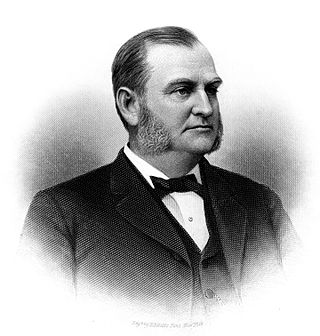
Oliver Ames was an American businessman, investor, philanthropist, and Republican politician who served as the 35th governor of Massachusetts from 1887 to 1890.
Frederick Lothrop Ames Jr. was a Massachusetts financier and socialite. He was the great-grandson of Oliver Ames, who established the Ames Shovel Company, grandson of Oliver Ames Jr., and son of Frederick Lothrop Ames.
Oliver Ames Jr. was president of Union Pacific Railroad when the railroad met the Central Pacific Railroad in Utah for the completion of the First transcontinental railroad in North America.
Oakes Angier Ames was an American businessman, investor, and philanthropist in the Ames family of North Easton, Massachusetts.
The H. H. Richardson Historic District of North Easton is a National Historic Landmark District in the village of North Easton in Easton, Massachusetts. It consists of five buildings designed by noted 19th-century architect Henry Hobson Richardson, and The Rockery, a war memorial designed by Frederick Law Olmsted. It was declared a National Historic Landmark in 1987.
Norton is a town in Bristol County, Massachusetts, United States, and contains the villages of Norton Center and Chartley. The population was 19,202 at the 2020 census. Home of Wheaton College, Norton hosted the Dell Technologies Championship, a tournament of the PGA Tour held annually on the Labor Day holiday weekend at the TPC Boston golf club until 2018.
The Ames Shovel Shops, also known as Ames Shovel Works or Ames Shovel Shop, is a historic 19th century industrial complex located in North Easton, Massachusetts. It is part of the North Easton Historic District, and consists of several granite buildings constructed between 1852 and 1885, along with several newer additions and outbuildings dating to about 1928.
Frederick Lothrop Ames was heir to a fortune in railroads and shovel manufacturing. He was Vice President of the Old Colony Railroad and director of the Union Pacific railroad. At the time of his death, Ames was reported to be the wealthiest person in Massachusetts.
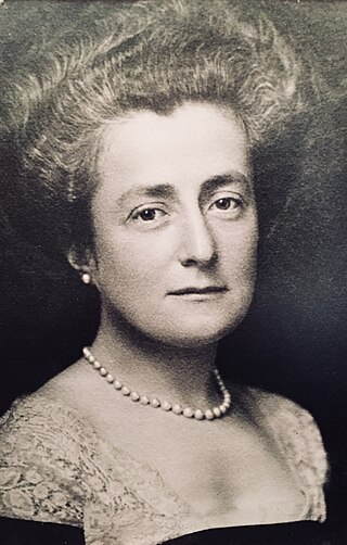
Mary Shreve (Ames) Frothingham was born into the prominent Ames family of Easton, Massachusetts. She held crucial roles in the development of many local and nationally recognized organizations through leadership and financial contributions. She assumed modesty in her personal life so as to give generously to others. Her legacy in her hometown can still be enjoyed by many at the Ames Free Library, Unity Church, Frothingham Hall, Frothingham Park and her home ‘Wayside’.
↑ "1950 Census of Population"(PDF). Bureau of the Census. 1952. Section 6, Pages 21-10 and 21-11, Massachusetts Table 6. Population of Counties by Minor Civil Divisions: 1930 to 1950. Retrieved July 12, 2011.
↑ "1920 Census of Population"(PDF). Bureau of the Census. Number of Inhabitants, by Counties and Minor Civil Divisions. Pages 21-5 through 21-7. Massachusetts Table 2. Population of Counties by Minor Civil Divisions: 1920, 1910, and 1920. Retrieved July 12, 2011.
↑ "1890 Census of the Population"(PDF). Department of the Interior, Census Office. Pages 179 through 182. Massachusetts Table 5. Population of States and Territories by Minor Civil Divisions: 1880 and 1890. Retrieved July 12, 2011.
↑ "1870 Census of the Population"(PDF). Department of the Interior, Census Office. 1872. Pages 217 through 220. Table IX. Population of Minor Civil Divisions, &c. Massachusetts. Retrieved July 12, 2011.
↑ "1860 Census"(PDF). Department of the Interior, Census Office. 1864. Pages 220 through 226. State of Massachusetts Table No. 3. Populations of Cities, Towns, &c. Retrieved July 12, 2011.
↑ "1850 Census"(PDF). Department of the Interior, Census Office. 1854. Pages 338 through 393. Populations of Cities, Towns, &c. Retrieved July 12, 2011.
This page is based on this Wikipedia article Text is available under the CC BY-SA 4.0 license; additional terms may apply. Images, videos and audio are available under their respective licenses.