West Bridgewater, Massachusetts

Last updated

West Bridgewater, Massachusetts
West Bridgewater Town Hall.JPG
West Bridgewater Town Hall
Seal of West Bridgewater, Massachusetts.png
Nickname: 
WB
Plymouth County Massachusetts incorporated and unincorporated areas West Bridgewater highlighted.svg
Location in Plymouth County in Massachusetts
Coordinates: 42°01′08″N71°00′30″W / 42.01889°N 71.00833°W / 42.01889; -71.00833
Country United States
State Massachusetts
County Plymouth
Settled1651
Incorporated1822
Government
  Type Open town meeting
Area
  Total15.7 sq mi (40.6 km2)
  Land15.3 sq mi (39.7 km2)
  Water0.3 sq mi (0.9 km2)
Elevation
65 ft (20 m)
Population
 (2020)
  Total7,707
  Density490/sq mi (190/km2)
Time zone UTC-5 (Eastern)
  Summer (DST) UTC-4 (Eastern)
ZIP code
02379
Area code 508 / 774
FIPS code 25-75260
GNIS feature ID0618354
Website Town website

West Bridgewater is a town in Plymouth County, Massachusetts, United States. The population was 7,707 at the 2020 census. [1]

Contents

History

West Bridgewater was first settled in 1651 as a part of Olde Bridgewater. The town separated from Bridgewater, Massachusetts and was officially incorporated in 1822, the second of the three communities to separate from Bridgewater (after North Bridgewater, now Brockton, and before East Bridgewater) over the span of three years. The town, like many in the area, had both agrarian and industrial roots; the Town River provided water power for milling and irrigation for farming. The town is home to the Keith House (1662), the oldest standing parsonage in the U.S. The town is also believed to be the site of the first industrial park in the U.S., now the site of the Town Park. The original Ames Shovel Works was located in the Town Park. Today, the town is mostly residential.

Geography

A field on the Town River A field on the Town River, West Bridgewater MA.jpg
A field on the Town River

According to the United States Census Bureau, the town has a total area of 15.7 square miles (40.6 km2), of which 15.3 square miles (39.7 km2) is land and 0.35 square miles (0.9 km2), or 2.25%, is water. [2] The town ranks 238th of 351 communities in the Commonwealth in terms of land area, and ranks nineteenth out of the twenty-seven towns in Plymouth County. West Bridgewater is bordered by Brockton to the north, East Bridgewater to the east, Bridgewater to the south, and Easton to the west, as well as a small section (less than a quarter of a mile long) of the southwestern corner that borders the town of Raynham. West Bridgewater's town center is approximately 4 miles (6.4 km) south of the center of Brockton, and is 25 miles (40 km) south of Boston.

West Bridgewater lies along the northeastern edge of the Hockomock Swamp, with a large section of the southwestern corner of town being covered by the swamp and its wildlife management area. There are also several other protected areas throughout the town, as well as several parks and a large pond surrounded by a state forest. The Town River also passes through the southern portion of town, branching off into several brooks throughout the town, as does the Salisbury River in the northeastern corner of town.

Transportation

Massachusetts Route 24 passes through the western half of town, with an exit at Route 106. Route 106 passes from east to west in the town, and meets at the center of town with Route 28. The Middleborough/Lakeville Line of the MBTA's commuter rail service passes through town, between the towns of Middleborough and Lakeville and South Station in Boston. There are no stops in West Bridgewater, but there are stops in Bridgewater and the Campello section of Brockton. There are no airports in the town; there are small strips in nearby Taunton and Mansfield, but the nearest national air service is at Logan International Airport in Boston. The town used to have rail service at Matfield Junction, Cochesett station. Matfield Junction was on the Middleborough branch of the Old Colony line, and Cochsett was on the Easton railroad branch; both were abandoned in the 1930s.

Bloom Bus Lines operates commuter service between Taunton, West Bridgewater, and Boston. [3]

Demographics

Historical population
YearPop.±%
1850 1,447    
1860 1,846+27.6%
1870 1,803−2.3%
1880 1,665−7.7%
1890 1,917+15.1%
1900 1,711−10.7%
1910 2,231+30.4%
1920 2,908+30.3%
1930 3,206+10.2%
1940 3,247+1.3%
1950 4,059+25.0%
1960 5,061+24.7%
1970 6,070+19.9%
1980 6,359+4.8%
1990 6,389+0.5%
2000 6,634+3.8%
2010 6,916+4.3%
2020 7,707+11.4%
2022*7,625−1.1%
* = population estimate.
Source: United States census records and Population Estimates Program data. [4] [5] [6] [7] [8] [9] [10] [11] [12] [13] [14]

As of the census [15] of 2000, there were 6,634 people, 2,444 households, and 1,796 families residing in the town. The population density was 421.5 inhabitants per square mile (162.7/km2). There were 2,510 housing units at an average density of 159.5 per square mile (61.6/km2). The racial makeup of the town was 96.40% White, 0.95% African American, 0.26% Native American, 0.68% Asian, 0.45% from other races, and 1.27% from two or more races. Hispanic or Latino of any race were 1.01% of the population.

There were 2,444 households, out of which 31.1% had children under the age of 18 living with them, 59.9% were married couples living together, 9.8% had a female householder with no husband present, and 26.5% were non-families. 21.7% of all households were made up of individuals, and 11.1% had someone living alone who was 65 years of age or older. The average household size was 2.66 and the average family size was 3.11. In the town, the population was spread out, with 22.7% under the age of 18, 6.7% from 18 to 24, 28.0% from 25 to 44, 24.7% from 45 to 64, and 17.8% who were 65 years of age or older. The median age was 40 years. For every 100 females, there were 95.7 males. For every 100 females age 18 and over, there were 90.9 males.

The median income for a household in the town was $55,958, and the median income for a family was $64,815. Males had a median income of $41,863 versus $31,835 for females. The per capita income for the town was $23,701. About 2.0% of families and 3.6% of the population were below the poverty line, including 0.5% of those under age 18 and 6.3% of those age 65 or over.

Government

On the national level, West Bridgewater is a part of Massachusetts's 8th congressional district, and has been represented since 2001 by Stephen Lynch.

On the state level, West Bridgewater is represented in the Massachusetts House of Representatives as a part of the Tenth Plymouth district, which includes portions of Brockton and East Bridgewater. The town is represented in the Massachusetts Senate as a part of the Norfolk, Bristol and Plymouth district, which includes all or parts of Avon, Braintree, Canton, East Bridgewater, Easton, Milton, Randolph, Sharon and Stoughton. [16] The town is patrolled by the Fourth (Middleborough) Barracks of Troop D of the Massachusetts State Police. [17]

West Bridgewater is governed on the local level by the open town meeting form of government, led by the town moderator and a board of selectmen. The current board of selectmen consists of Meredith Anderson, Anthony Kinahan, and Denise Reyes. [18]

The town operates its own police and fire departments, both of which are headquartered together on Route 106 just west of Route 28. The fire department also has an ambulance service, bringing emergency room patients to either Brockton Hospital or Caritas Good Samaritan Hospital in Brockton. The town has its own post office, located on Route 28 across the street from the town hall. West Bridgewater Public Library is located around the corner from the post office, and is a member of the SAILS Library Network.

Education

West Bridgewater operates its own school system for its approximately 1,220 students. The Spring Street School, not far from the town center, serves pre-kindergarten and kindergarten students. The Rose L. MacDonald School, located closer to the geographic center of the town, serves first, second and third grade students. The Howard School, between the post office and the library, serves fourth, fifth and sixth grade students. The West Bridgewater Middle-Senior High School, located along Route 106, serves students from grades 7–12. West Bridgewater's athletics teams are known as the Wildcats, and their colors are maroon and white. The football team plays Holbrook-Avon for its Thanksgiving Day football game, having recently ended its tradition of playing Freetown-Lakeville's Apponequet high school. Before that East Bridgewater had been the original rival.

In addition to the high school, students may choose to attend Southeastern Regional Vocational Technical High School in South Easton free of charge. The town is also home to the New England Baptist Academy, a private Christian school serving all grades. There are also other private schools in neighboring Bridgewater and Brockton. The nearest colleges are Massasoit Community College in Brockton, Stonehill College in Easton, and Bridgewater State University in Bridgewater.

Notable people

See also

Related Research Articles

<span class="mw-page-title-main">Plymouth County, Massachusetts</span> County in Massachusetts, United States

Plymouth County is a county in the U.S. state of Massachusetts, south of Boston. As of the 2020 census, the population was 530,819. Its county seats are Plymouth and Brockton. In 1685, the county was created by the Plymouth General Court, the legislature of Plymouth Colony, predating its annexation by the Massachusetts Bay Colony.

<span class="mw-page-title-main">Berkley, Massachusetts</span> Town in Massachusetts, United States

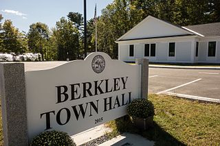
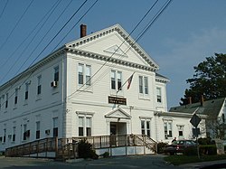
Berkley is a town in Bristol County, Massachusetts, United States, located south of Boston and east of Providence, Rhode Island. The population was 6,764 according to the 2020 census, making it the least populated town in the county.

<span class="mw-page-title-main">Easton, Massachusetts</span> Town in Massachusetts, United States

Easton is a town in Bristol County, Massachusetts, United States. The population was 25,058 at the 2020 census. It is part of the Greater Boston area.

<span class="mw-page-title-main">Freetown, Massachusetts</span> Town in Massachusetts, United States

Freetown is a town in Bristol County, Massachusetts, United States. The population was 9,206 at the 2020 census.

<span class="mw-page-title-main">Raynham, Massachusetts</span> Town in Massachusetts, United States

Raynham is a town in Bristol County, Massachusetts, United States, located approximately 32 miles (51 km) south of Boston and 22 miles (35 km) northeast of Providence, Rhode Island. The population was 15,082 at the 2020 census. It has one village, Raynham Center.

<span class="mw-page-title-main">Stoughton, Massachusetts</span> Town in Massachusetts, United States

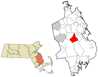
Stoughton is a town in Norfolk County, Massachusetts, United States. The population was 29,281 at the 2020 census. The town is located approximately 17 miles (27 km) from Boston, 31 miles (50 km) from Providence, Rhode Island, and 35 miles (56 km) from Cape Cod.

<span class="mw-page-title-main">Brockton, Massachusetts</span> City in Massachusetts, United States

Brockton is a city in Plymouth County, Massachusetts, United States; the population was 105,643 at the 2020 United States census. Along with Plymouth, it is one of the two county seats of Plymouth County. It is the sixth-largest city in Massachusetts and is sometimes referred to as the "City of Champions", due to the success of native boxers Rocky Marciano and Marvin Hagler, as well as its successful Brockton High School sports programs. Two villages within it are Montello and Campello, both of which have MBTA Commuter Rail Stations and post offices. Campello is the smallest neighborhood, but also the most populous. Brockton hosts a baseball team, the Brockton Rox. It is the second-windiest city in the United States, with an average wind speed of 14.3 mph (23.0 km/h).

<span class="mw-page-title-main">Carver, Massachusetts</span> Town in Massachusetts, United States

Carver is a town in Plymouth County, Massachusetts, United States. The population was 11,645 at the 2020 census. It is named for John Carver, the first governor of the Plymouth Colony. The town features two popular tourist attractions: Edaville USA theme park and King Richard's Faire, the largest and longest-running renaissance fair in New England.

<span class="mw-page-title-main">East Bridgewater, Massachusetts</span> Town in Massachusetts, United States

East Bridgewater is a town in Plymouth County, Massachusetts, United States. The population was 14,440 at the 2020 census. It is also a part of Massachusetts' 8th congressional district, of which it is represented by Stephen Lynch.

<span class="mw-page-title-main">Halifax, Massachusetts</span> Town in Massachusetts, United States

Halifax is a town in Plymouth County, Massachusetts, United States. The population was 7,749 at the 2020 census.

<span class="mw-page-title-main">Lakeville, Massachusetts</span> Town in Massachusetts, United States

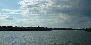
Lakeville is a town in Plymouth County, Massachusetts, United States. The population was 11,523 at the 2020 census.

<span class="mw-page-title-main">Marion, Massachusetts</span> Town in Massachusetts, United States

Marion is a town in Plymouth County, Massachusetts, United States. The population was 5,347 at the 2020 census.

<span class="mw-page-title-main">Middleborough, Massachusetts</span> Town in Massachusetts, United States

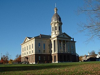
Middleborough is a town in Plymouth County, Massachusetts, United States. The population was 24,245 at the 2020 census. The census-designated place of Middleborough Center corresponds to the main village and commercial center of the town. It is the second largest municipality by land area in Massachusetts and nineteenth largest in New England. Middleborough proclaims itself to be the "Cranberry Capital of the World". Cranberry production remains a significant part of the local economy. In 2015, approximately 1,400 acres of the town were used to grow the crop, accounting for 3% of all land used to harvest cranberry bogs in the United States.

<span class="mw-page-title-main">Plympton, Massachusetts</span> Town in Massachusetts, United States

Plympton is a town in Plymouth County, Massachusetts, United States. The population was 2,930 at the 2020 census. The United States senator William Bradford was born here.

<span class="mw-page-title-main">Rochester, Massachusetts</span> Town in Massachusetts

Rochester is a town in Plymouth County, Massachusetts, United States. The population was 5,717 at the 2020 census.

<span class="mw-page-title-main">Wareham, Massachusetts</span> Town in Massachusetts, United States

Wareham is a town in Plymouth County, Massachusetts, United States. As of the 2022 census, the town had a population of 23,303.

<span class="mw-page-title-main">Whitman, Massachusetts</span> Town in Massachusetts, United States

Whitman is a town in Plymouth County, Massachusetts, United States. The population was 15,121 at the 2020 census. It is notable as being the place where the chocolate chip cookie was invented.

<span class="mw-page-title-main">Abington, Massachusetts</span> Town in Massachusetts, United States

Abington is a town in Plymouth County, Massachusetts, United States, 20 miles (32 km) southeast of Boston. The population was 17,062 at the 2020 census.

<span class="mw-page-title-main">Bridgewater, Massachusetts</span> City in Massachusetts, United States

Bridgewater is a town located in Plymouth County, in the state of Massachusetts, United States. As of the 2020 U.S. Census, the town's population was 28,633. Bridgewater is located approximately 25 miles (40 km) south of Boston and approximately 35 miles east of Providence, Rhode Island.

<span class="mw-page-title-main">Hanson, Massachusetts</span> Town in the United States

Hanson is a town in Plymouth County, Massachusetts, United States. Part of Greater Boston, Hanson is located 20 miles (32 km) south of Boston and is one of the inland towns of the South Shore. The population was 10,639 at the 2020 census.

References

  1. "Census - Geography Profile: West Bridgewater town, Plymouth County, Massachusetts". United States Census Bureau . Retrieved November 10, 2021.
  2. "Geographic Identifiers: 2010 Demographic Profile Data (G001): West Bridgewater town, Plymouth County, Massachusetts". United States Census Bureau . Retrieved March 22, 2012.
  3. "Commuter Services to Boston | Bloom Bus" . Retrieved February 19, 2021.
  4. "Total Population (P1), 2010 Census Summary File 1". American FactFinder, All County Subdivisions within Massachusetts. United States Census Bureau. 2010.
  5. "Massachusetts by Place and County Subdivision - GCT-T1. Population Estimates". United States Census Bureau. Retrieved July 12, 2011.
  6. "1990 Census of Population, General Population Characteristics: Massachusetts" (PDF). US Census Bureau. December 1990. Table 76: General Characteristics of Persons, Households, and Families: 1990. 1990 CP-1-23. Retrieved July 12, 2011.
  7. "1980 Census of the Population, Number of Inhabitants: Massachusetts" (PDF). US Census Bureau. December 1981. Table 4. Populations of County Subdivisions: 1960 to 1980. PC80-1-A23. Retrieved July 12, 2011.
  8. "1950 Census of Population" (PDF). Bureau of the Census. 1952. Section 6, Pages 21-10 and 21-11, Massachusetts Table 6. Population of Counties by Minor Civil Divisions: 1930 to 1950. Retrieved July 12, 2011.
  9. "1920 Census of Population" (PDF). Bureau of the Census. Number of Inhabitants, by Counties and Minor Civil Divisions. Pages 21-5 through 21-7. Massachusetts Table 2. Population of Counties by Minor Civil Divisions: 1920, 1910, and 1920. Retrieved July 12, 2011.
  10. "1890 Census of the Population" (PDF). Department of the Interior, Census Office. Pages 179 through 182. Massachusetts Table 5. Population of States and Territories by Minor Civil Divisions: 1880 and 1890. Retrieved July 12, 2011.
  11. "1870 Census of the Population" (PDF). Department of the Interior, Census Office. 1872. Pages 217 through 220. Table IX. Population of Minor Civil Divisions, &c. Massachusetts. Retrieved July 12, 2011.
  12. "1860 Census" (PDF). Department of the Interior, Census Office. 1864. Pages 220 through 226. State of Massachusetts Table No. 3. Populations of Cities, Towns, &c. Retrieved July 12, 2011.
  13. "1850 Census" (PDF). Department of the Interior, Census Office. 1854. Pages 338 through 393. Populations of Cities, Towns, &c. Retrieved July 12, 2011.
  14. "City and Town Population Totals: 2020−2022". United States Census Bureau . Retrieved November 24, 2023.
  15. "U.S. Census website". United States Census Bureau . Retrieved January 31, 2008.
  16. Index of Legislative Representation by City and Town, from Mass.gov
  17. Station D-4, SP Middleborough
  18. "Board of Selectmen".
  19. Who Was Who in America, Historical Volume, 1607-1896. Chicago: Marquis Who's Who. 1963.
  20. "Article: Cyrus Alger", Encyclopedia Americana , v.1
  21. Devitt, Phil (August 12, 2021). "What Seth Meyers says about Fall River's Wally Feresten, 'SNL,' 'Late Night' cue card guy". The Herald News. Retrieved December 19, 2021.