Flag Rock lies off shore White Horse Beach in Plymouth, Massachusetts.
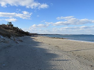
White Horse Beach is a village of Plymouth, Massachusetts, United States. It is located on Cape Cod Bay, south of Priscilla Beach. Much of the southern end of the beach, which is also known as Taylor Avenue Beach, south of the outflow of Bartlett Pond, either has cottages on it or has a fenced off conservation area to protect the dunes and fragile plant life.
At the north end of the beach is a rock sticking out of the water with an American flag painted on. According to local lore, this act of patriotism was performed to cover a Nazi swastika painted on the rock. In the summer of 1941 local teenagers painted the first flag and went on to join the armed forces after Pearl Harbor was bombed in December 1941. The harsh winter storms washed the flag thin so the swastika showed through. The next Fourth of July the tradition of re-painting the flag was born.
There is a small business district just beyond the north end of the beach. It has a general store and a Post Office. Its ZIP code is 02381. Residents and businesses in this village that are non-Post Office box holders use Plymouth's ZIP code of 02360. Further inland was St. Catherine's Chapel (which had fallen into disrepair, was sold to an individual with local ties who razed the structure and directed the landscaping of the property with grass and trees to serve as a small park.) White Horse Cemetery, which dates back to the early 18th century. The Post Office, originally inside the General Store, leases a space in the former White Horse Bowling Alley that included pool tables, and pinball machines. Pin setting was done manually by "Pin Spotters" who had to move fast to keep up with the Bowlers. Two hotels were located on White Horse Beach, the Mayflower and the White Horse Hotel. The Mayflower has since burned and the area developed into Condos. White Horse Hotel was torn down in the sixties to make way for a parking lot.
Annual activities
White Horse Beach is widely known for its Independence Day celebrations, which are held on July 3 annually. This early celebration of Independence Day extends back to the 1800s, when residents burned scrap and driftwood on the beach. Tradition would dictate that these bonfires be extinguished by the rising tide. Depending on the phase of the moon, festivities would go late into the evening. In recent years, the town fire department has begun to request permits for bonfires (non-permitted bonfires are sometimes removed by the fire department). Historically, town officials have requested that these fires be extinguished no earlier than midnight. Also in recent years, the celebrations have experienced a soft "crackdown by police and fire departments" to deter the historically massive bonfires and fireworks;[1] "NO Public Parking or Restroom Facilities" are officially advertised on location for this event to deter non-residents from attending.
Landmarks and recreation
White Horse Beach is also in close proximity to the Priscilla Beach Theatre, a professional center for drama education and performance dating back to the 1930s. It is also the location of Bartlett Pond, which is a shallow eutrophic pond located inland from White Horse Beach. This pond is fed by Beaver Dam Brook and its outlet flows into Cape Cod Bay. White Horse was known as part of the "Irish Riviera" due to the large population of Irish descendants from Dorchester, Somerville, and South Boston who would vacation there in the 1940s, 50s, and 60s. It was the typical summer community that one would find on the South Shore and Cape Cod. Many cottages from that era still stand to this day, though some have been destroyed by storms and a great many have been renovated to year-round homes, partly due to the Boston real estate market. This infusion of year-round residents had a dramatic effect on the local economy as White Horse Beach transitioned from a seasonal community of vacationers to a bedroom community of greater Boston.
White Horse Beach landmarks include:
Located atop Manomet Point is a small monument marking the location of the Manomet Point Life-Saving Station. Starting in 1874 the Station and its Surfmen kept a watchful eye on vessels seeking the calmer waters closer to land along the South Shore. The monument commemorates the Surfmen who served this community and those that made the supreme sacrifice in an attempt to rescue crew members of a floundering vessel (Robert E. Lee).
John Alden was a crew member on the historic 1620 voyage of the Mayflower which brought the English settlers commonly known as Pilgrims to Plymouth Colony in Massachusetts. He was hired in Southampton, England as the ship's cooper, responsible for maintaining the ship's barrels. He was a member of the ship's crew and not a settler, yet he decided to remain in Plymouth Colony when the Mayflower returned to England. He was a signatory to the Mayflower Compact.
Cape Cod is an arm-shaped peninsula extending into the Atlantic Ocean from the southeastern corner of Massachusetts, in the northeastern United States. Its historic, maritime character and ample beaches attract heavy tourism during the summer months. The name Cape Cod, coined in 1602 by Bartholomew Gosnold, is the ninth oldest English place-name in the U.S.
Wareham is a town in Plymouth County, Massachusetts, United States. As of the 2022 census, the town had a population of 23,303.
Plymouth is a town and county seat of Plymouth County, Massachusetts, United States. Located in Greater Boston, the town holds a place of great prominence in American history, folklore, and culture, and is known as "America's Hometown". Plymouth was the site of the colony founded in 1620 by the Mayflower Pilgrims, where New England was first established. It is the oldest municipality in New England and one of the oldest in the United States. The town has served as the location of several prominent events, one of the more notable being the First Thanksgiving feast. Plymouth served as the capital of Plymouth Colony from its founding in 1620 until the colony's merger with the Massachusetts Bay Colony in 1691. The English explorer John Smith named the area Plymouth and the region 'New England' during his voyage of 1614. It was a later coincidence that, after an aborted attempt to make the 1620 trans-Atlantic crossing from Southampton, the Mayflower finally set sail for America from Plymouth, England.
Dennis is a town in Barnstable County, Massachusetts, United States, located near the center of Cape Cod. The population was 14,674 at the 2020 census.
Plymouth Rock is the historical site of disembarkation of the Mayflower Pilgrims who founded Plymouth Colony in December 1620.
Richard Warren was one of the passengers on the Pilgrim ship Mayflower and a signer of the Mayflower Compact.
Sagamore Beach is a village on Cape Cod, in the town of Bourne, Massachusetts. The northern half of the Sagamore census-designated place, Sagamore Beach faces Cape Cod Bay, and the Cape Cod Canal courses through it. Along with Buzzards Bay and Bournedale, it is one of three communities that comprise the county of Barnstable.
The Pilgrim Hall Museum at 75 Court Street in Plymouth, Massachusetts is the oldest public museum in the United States in continuous operation, having opened in 1824.
Samuel Fuller was a passenger on the historic 1620 voyage of the Pilgrim ship Mayflower and became a respected church deacon and the physician for Plymouth Colony.
There are several neighborhoods in Plymouth, Massachusetts. With a total area of 134.0 mi2 (347.0 km2), Plymouth is the largest municipality in Massachusetts by area. In addition, with a population of 51,701 at the 2000 census and an estimated population of 57,901 in 2007, Plymouth is the second-largest town in the state by population (after Framingham. As such, Plymouth is home to many distinct neighborhoods and geographical locations.
Manomet is a seaside village of Plymouth, Massachusetts, United States. It is named for the Wampanoag village of Manomet located among the Manomet Ponds. Manomet has a Post Office in the business district whose ZIP code is 02345. Residents and businesses in this village that are non-Post Office box holders use Plymouth's ZIP code of 02360.
South Plymouth is the portion of Plymouth, Massachusetts, United States that covers much of the southern section of the town beginning at the Pine Hills, a large, mostly undeveloped forested area south of Plymouth Beach, Chiltonville and South Pond. The remainder of the section is south and east of the northeastern entrance to Myles Standish State Forest, stretching to the Bourne and Wareham town lines.
Cedarville is the southeasternmost village in Plymouth, Massachusetts, United States. It is bounded to the north by Ellisville Road and Hedges Pond, to the south by the town of Bourne, to the west by Little Herring Pond and Great Herring Pond, and to the east by Cape Cod Bay.
Pine Hills is a sparsely populated hilly region located in Plymouth, Massachusetts, in the United States. It is a large, mostly undeveloped hilly and forested area lying south of Plymouth Beach and Chiltonville, north of Manomet, and east of Route 3, where the southern portion of the region can be accessed from Exit 3, and the northern portion can be accessed from Exit 4. The area rises from Plymouth Bay at Rocky Point, which is considered to be located in the foothills of the region, and runs southwest. Route 3A winds through the heart of the Pine Hills. The region consists of the Rocky Point neighborhood in the north and The Pinehills, a new residential and commercial development in the extreme southern part of the area.
Priscilla Beach is a village of Plymouth, Massachusetts, United States. It consists of a private beach on Cape Cod Bay in the Manomet section of Plymouth, located between Pilgrim Station and White Horse Beach. The Priscilla Beach Association (PBA) was formed on July 17, 1937, to promote and foster the social and civic welfare of the residents and owners of real estate in Priscilla Beach. The PBA is dedicated to the protection, preservation, and improvement of Priscilla Beach as a private beach for the interest of the property owners in Priscilla Beach.
Bartlett Pond is a 33-acre (130,000 m2) pond in the Manomet section of Plymouth, Massachusetts. The inflow of the pond is Beaver Dam Brook, and the outflow is a river that empties into Cape Cod Bay. White Horse Beach nearly surrounds the pond, lying to the southwest, west and north. Manomet Heights lies on the eastern shore.
The Mayflower Inn on Manomet Point, Plymouth Massachusetts was a large wooden structure set atop a hill off Point Road, with sweeping vistas of White Horse Beach to the north and the Cape Cod Bay and Scooks Pond to the south. Its exterior is similar in design to the Chatham Bars Inn, located in Chatham Massachusetts, which opened in 1914.
United States Coast Guard Station Manomet Point was a United States Life-Saving Service station – and later a United States Coast Guard station – located on Manomet Point in Manomet, Massachusetts. The station was a sub-unit of Sector Southeast New England.
This page is based on this Wikipedia article Text is available under the CC BY-SA 4.0 license; additional terms may apply. Images, videos and audio are available under their respective licenses.