Salem, New Hampshire

Last updated

Salem, New Hampshire
Town
Salem, NH Town Seal.png
Motto(s): 
Industry, Commerce, Recreation
Rockingham County New Hampshire incorporated and unincorporated areas Salem highlighted.svg
Location in Rockingham County and the state of New Hampshire.
Coordinates: 42°47′18″N71°12′03″W / 42.78833°N 71.20083°W / 42.78833; -71.20083
CountryUnited States
State New Hampshire
County Rockingham
Incorporated 1750
Villages
Government
   Town council
Members
  Town ManagerChristopher A. Dillon
Area
[2]
  Total25.90 sq mi (67.07 km2)
  Land24.84 sq mi (64.33 km2)
  Water1.05 sq mi (2.73 km2)  4.07%
Elevation
131 ft (40 m)
Population
 (2020)
  Total30,089
  Density1,209/sq mi (466.7/km2)
Time zone UTC−5 (Eastern)
  Summer (DST) UTC−4 (Eastern)
ZIP Code
03079
Area code 603
FIPS code 33-66660
GNIS feature ID0873713
Website www.townofsalemnh.org

Salem is a town in Rockingham County, New Hampshire, United States. The population was 30,089 at the 2020 census [3] and an estimated 30,647 in 2022.[ citation needed ] Salem is a northern suburb of Boston located on Interstate 93. As the first town along I-93 northbound in New Hampshire, which lacks any state sales tax, Salem has grown into a regional commercial hub for many nearby Massachusetts towns, anchored by the Mall at Rockingham Park and Tuscan Village. Other major sites include Canobie Lake Park, a large amusement park; and America's Stonehenge, a stone structure of disputed origins. It is the former home of Rockingham Park, a horse racetrack. The Sununu political family hails from Salem, including former New Hampshire governor and White House Chief of Staff John H. Sununu, and his sons John E. Sununu, a former U.S. senator, and Chris Sununu, current New Hampshire governor.

Contents

Salem was named on Money magazine's "Best Places to Live 2020" list. [4]

History

The Square, now known as Salem Depot, in 1908 The Square, Salem Depot, NH.jpg
The Square, now known as Salem Depot, in 1908

The area was first settled in 1652. As early as 1736, Salem was the "North Parish" of Methuen, Massachusetts, or "Methuen District". In 1741, when the boundary line between Massachusetts and New Hampshire was fixed, the "North Parish" became part of New Hampshire, and was given the name "Salem", taken from nearby Salem, Massachusetts. The town was incorporated in 1750 by colonial governor Benning Wentworth. [5] The meetinghouse of the old north parish, erected in 1738, still stands, eventually becoming the town hall of Salem before it was turned into the Salem Historical Society museum. [6]

In 1902, Canobie Lake Park was established in Salem by the Massachusetts Northeast Street Railway Company to encourage leisure excursions on its trolleys. The plan was successful, and the enterprise quickly became one of the leading resorts of its type in New England. Crowds arrived from all over, including the nearby mill towns of Haverhill, Lawrence, Lowell and Methuen in Massachusetts, and Manchester and Nashua in New Hampshire. Factory workers and others found respite strolling along tree-lined promenades, between flower beds or beside the lake. Rides, arcades, and a dance hall provided lively entertainments. The rise of the automobile, however, brought the decline of the trolley. But Canobie Lake Park, one of the few former street railway amusement resorts still in existence, continues to be popular. [7]

Other features of Salem's tourism history include America's Stonehenge, a curiosity (formerly "Mystery Hill"). Other attractions include the Icenter, a skating arena, as well as Field of Dreams and Hedgehog Pond Park.

Starting in the 1950s, Salem developed rapidly as part of Greater Boston, with suburban-style residential neighborhoods and a long strip of commercial development along NH Route 28. Commercial construction has continued to focus on Route 28, as well as on the commercial zone off Exit 2 on Interstate 93. Starting in 2017, the Tuscan Village complex has been under construction, a multi-million dollar mixed-use commercial property that includes retail, medical offices, condos, and apartments. The complex is being built on the site of the former Rockingham Park race track. [8]

The Manchester and Lawrence branch of the Boston and Maine Railroad ran through Salem until 2001. In 2009, the New Hampshire Department of Transportation commissioned a study exploring the reactivation of the branch and instituting commuter rail service connecting to the MBTA Haverhill Line and onward to Boston. The study's cost/benefit analysis recommended taking no action to reactivate beyond preserving the option for consideration at a future time. [9]

Geography

Town offices SalemNH TownOffices.jpg
Town offices

According to the United States Census Bureau, the town has a total area of 25.9 square miles (67.1 km2), of which 24.8 square miles (64.3 km2) are land and 1.0 square mile (2.7 km2) are water, comprising 4.07% of the town. [2] Salem is drained by the Spicket River and its tributary Policy Brook, part of the Merrimack River watershed. Canobie Lake is on the western boundary, Arlington Mill Reservoir is in the north, and World End Pond is in the southeast. None of the town's residential water supply incorporates sodium fluoride, a water additive that helps ensure strong teeth enamel. [10] The highest point in Salem is the summit of Gordon's Hill, at 380 feet (120 m) above sea level, along the town's western border.

Salem is the first New Hampshire town encountered when traveling north from Massachusetts on Interstate 93. The interstate's first two New Hampshire exits are within the town. Via I-93, Boston is 35 miles (56 km) to the south and Manchester is 20 miles (32 km) to the northwest.

Adjacent municipalities

Demographics

Historical population
CensusPop.Note
1790 1,218
1800 1,077−11.6%
1810 1,1799.5%
1820 1,31111.2%
1830 1,310−0.1%
1840 1,4087.5%
1850 1,55510.4%
1860 1,6707.4%
1870 1,603−4.0%
1880 1,80912.9%
1890 1,805−0.2%
1900 2,04113.1%
1910 2,1173.7%
1920 2,3189.5%
1930 2,75118.7%
1940 3,26718.8%
1950 4,80547.1%
1960 9,21091.7%
1970 20,142118.7%
1980 24,12419.8%
1990 25,7466.7%
2000 28,1129.2%
2010 28,7762.4%
2020 30,0894.6%
U.S. Decennial Census [11]
Under the Apple Tree in 1908, Canobie Lake Park Apple Tree, Canobie Lake Park.jpg
Under the Apple Tree in 1908, Canobie Lake Park

At the 2000 census, [12] there were 28,112 people, 10,402 households and 7,603 families residing in the town. The population density was 1,138.0 inhabitants per square mile (439.4/km2). There were 10,866 housing units at an average density of 439.9 per square mile (169.8/km2). The racial makeup of the town was 95.01% White, 0.55% African American, 0.21% Native American, 2.27% Asian, 0.06% Pacific Islander, 0.83% from other races, and 1.07% from two or more races. Hispanic or Latino of any race were 1.96% of the population.

There were 10,402 households, of which 34.3% had children under the age of 18 living with them, 60.6% were married couples living together, 8.7% had a female householder with no husband present, and 26.9% were non-families. Of all households 21.2% were made up of individuals, and 7.5% had someone living alone who was 65 years of age or older. The average household size was 2.69 and the average family size was 3.16.

Age distribution was 25.3% under the age of 18, 6.2% from 18 to 24, 31.7% from 25 to 44, 25.3% from 45 to 64, and 11.5% who were 65 years of age or older. The median age was 38 years. For every 100 females, there were 99.1 males. For every 100 females age 18 and over, there were 96.9 males.

The median household income was $58,090, and the median family income was $67,278. Males had a median income of $46,330 versus $31,031 for females. The per capita income for the town was $26,170. About 3.1% of families and 4.1% of the population were below the poverty line, including 5.1% of those under age 18 and 7.6% of those age 65 or over.

Government

Salem town vote
by party in presidential elections [13]
Year Democratic Republican Third Parties
2020 42.81% 7,63855.88%9,9691.31% 234
2016 37.41% 6,06857.40%9,3125.19% 842
2012 41.66% 6,02657.27%8,2851.07% 155
2008 45.27% 6,83853.45%8,0731.28% 194
2004 45.06% 6,47254.28%7,7970.66% 95
2000 47.73% 5,71147.75%5,7134.52% 541
1996 47.82%5,16439.42% 4,25712.76% 1,378
1992 33.49% 4,18438.93%4,86427.59% 3,447
1988 31.97% 3,51266.57%7,3141.47% 161
1984 31.33% 3,02168.27%6,5830.39% 38
1980 31.51% 3,04755.31%5,34813.19% 1,275
1976 54.10%4,98343.37% 3,9942.53% 233
1972 44.46% 3,92354.70%4,8270.84% 74
1968 50.44%3,63745.80% 3,3023.76% 271
1964 63.45%3,68536.55% 2,1230.00% 0
1960 42.87% 1,99357.13%2,6560.00% 0

Salem's town government consists of a town council and a town manager. Salem is a part of New Hampshire House District 25 and is currently represented by nine Republican representatives: Lori Ball, Tanya Donnelly, Fred Doucette, John Janigian, Dennis Mannion, Valerie McDonnell, Joe Sweeney, John Sytek and Susan Vandecasteele. In the New Hampshire Senate, Salem is in the 22nd District and is currently represented by Republican Daryl Abbas. On the New Hampshire Executive Council, Salem is in District 3 and is currently represented by Republican Janet Stevens. In the U.S. House of Representatives, Salem is in New Hampshire's 2nd congressional district and is currently represented by Democrat Ann McLane Kuster.

Salem is a Republican stronghold in presidential elections. No Democratic presidential nominee has carried the town since Bill Clinton received a plurality of the vote in 1996.

Education

Salem public schools spend $5,544 per student. The average school expenditure in the U.S. is $5,678. There are about 16.1 students per teacher in Salem. [14]

Colleges
High school
Administration
Private school

Transportation

Four New Hampshire state routes and one Interstate Highway cross Salem.

The nearest airport is Manchester–Boston Regional Airport along the border of Londonderry and Manchester. The nearest rail service is the Haverhill Line of the MBTA Commuter Rail which can be accessed at Lawrence station in Lawrence, Massachusetts. The nearest Amtrak station is at Haverhill station in Haverhill, Massachusetts.

Notable people

Rockingham Park racetrack was located in Salem. As mentioned in the film The Sting starring Paul Newman and Robert Redford, it was central to that film's plot.

Scenes from the original The Thomas Crown Affair were filmed at the Salem glider airport, which is now Campbell's Scottish Highlands Golf Course.

Points of interest

Related Research Articles

<span class="mw-page-title-main">Essex County, Massachusetts</span> County in Massachusetts, United States

Essex County is a county in the northeastern part of the U.S. state of Massachusetts. At the 2020 census, the total population was 809,829, making it the third-most populous county in the state, and the seventy-eighth-most populous in the country. It is part of the Greater Boston area. The largest city in Essex County is Lynn. The county was named after the English county of Essex. It has two traditional county seats: Salem and Lawrence. Prior to the dissolution of the county government in 1999, Salem had jurisdiction over the Southern Essex District, and Lawrence had jurisdiction over the Northern Essex District, but currently these cities do not function as seats of government. However, the county and the districts remain as administrative regions recognized by various governmental agencies, which gathered vital statistics or disposed of judicial case loads under these geographic subdivisions, and are required to keep the records based on them. The county has been designated the Essex National Heritage Area by the National Park Service.

<span class="mw-page-title-main">Interstate 93</span> Interstate Highway in Massachusetts, New Hampshire, and Vermont in the United States

Interstate 93 (I-93) is an Interstate Highway in the New England states of Massachusetts, New Hampshire, and Vermont in the United States. Spanning approximately 190 miles (310 km) along a north–south axis, it is one of three primary Interstate Highways located entirely within New England; the other two are I-89 and I-91. The largest cities along the route are Boston, Massachusetts, and Manchester, New Hampshire; it also travels through the New Hampshire state capital of Concord.

<span class="mw-page-title-main">Rockingham County, New Hampshire</span> County in New Hampshire, United States

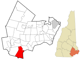
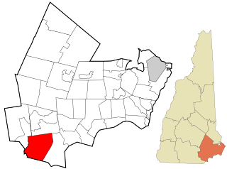
Rockingham County is a county in the U.S. state of New Hampshire. As of the 2020 census, the population was 314,176, making it New Hampshire's second-most populous county. The county seat is Brentwood. Rockingham County is part of the Boston-Cambridge-Newton, MA-NH Metropolitan Statistical Area and the greater Boston-Worcester-Providence, MA-RI-NH-CT Combined Statistical Area. Per the 2020 census, it was New Hampshire's fastest growing county from 2010 to 2020.

<span class="mw-page-title-main">Methuen, Massachusetts</span> City in Massachusetts, United States

Methuen is a 23-square-mile city in Essex County, Massachusetts, United States. The population was 53,059 at the 2020 census. Methuen lies along the northwestern edge of Essex County, just east of Middlesex County and just south of Rockingham County, New Hampshire. The city is bordered by Haverhill to the northeast, North Andover to the southeast, Lawrence and Andover to the south, Dracut to the west, Pelham, New Hampshire to the northwest, and Salem, New Hampshire to the north. Methuen is located 17 miles (27 km) southwest from Newburyport, 30 miles (48 km) north-northwest of Boston and 25 miles (40 km) south-southeast of Manchester, New Hampshire.

<span class="mw-page-title-main">Pelham, New Hampshire</span> Town in New Hampshire, United States

Pelham is a town in Hillsborough County, New Hampshire, United States. The population was 14,222 at the 2020 census, up from 12,897 at the 2010 census.

<span class="mw-page-title-main">Atkinson, New Hampshire</span> Place in New Hampshire, United States

Atkinson is a town in Rockingham County, New Hampshire, United States. The population was 7,087 at the 2020 census.

<span class="mw-page-title-main">Plaistow, New Hampshire</span> Place in New Hampshire, United States

Plaistow is a town in Rockingham County, New Hampshire, United States. The population was 7,830 at the 2020 census.

<span class="mw-page-title-main">Windham, New Hampshire</span> Town in New Hampshire, United States

Windham is a suburban town in Rockingham County, New Hampshire, United States. The population at the 2020 census was 15,817, up from 13,592 in 2010.

<span class="mw-page-title-main">Londonderry, New Hampshire</span> Town in Rockingham County, New Hampshire, United States of America

Londonderry is a town in western Rockingham County, New Hampshire, United States. It sits between Manchester and Derry, the largest and fourth-largest communities in the state. The population was 25,826 at the 2020 census. Londonderry is known for its apple orchards and is home to the headquarters of Stonyfield Farm and part of Manchester–Boston Regional Airport.

<span class="mw-page-title-main">Derry, New Hampshire</span> Town in New Hampshire, United States

Derry is a town in Rockingham County, New Hampshire, United States. The population was 34,317 at the 2020 census. Although it is a town and not a city, Derry is the most populous community in Rockingham County and the 4th most populous in the state. The town's nickname, "Spacetown", derives from the fact that Derry is the birthplace of Alan Shepard, the first astronaut from the United States in space. Derry was also for a time the home of the poet Robert Frost and his family.

<span class="mw-page-title-main">Greater Boston</span> Combined Statistical Area in the US

Greater Boston is the metropolitan region of New England encompassing the municipality of Boston, the capital of the U.S. state of Massachusetts and the most populous city in New England, and its surrounding areas. The most stringent definition of the region consists of most of the eastern third of mainland Massachusetts, excluding the Merrimack Valley and most of Southeastern Massachusetts, though most definitions include much of these areas and portions of southern New Hampshire.

<span class="mw-page-title-main">New Hampshire Route 111</span> State highway in southeastern New Hampshire, US

New Hampshire Route 111 is a 50.027-mile-long (80.511 km) east–west highway in Hillsborough and Rockingham counties in southeastern New Hampshire. The road runs from the Massachusetts border at Hollis to North Hampton on the Atlantic shore.

<span class="mw-page-title-main">New Hampshire Route 28</span> State highway in eastern New Hampshire, US

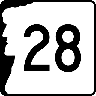
New Hampshire Route 28 is an 85.413-mile-long (137.459 km) north–south state highway in eastern New Hampshire. It connects the town of Ossipee in east-central New Hampshire with Salem on the Massachusetts border, while passing through Manchester, the largest city in the state.

<span class="mw-page-title-main">New Hampshire Route 38</span> State highway in southern New Hampshire, US

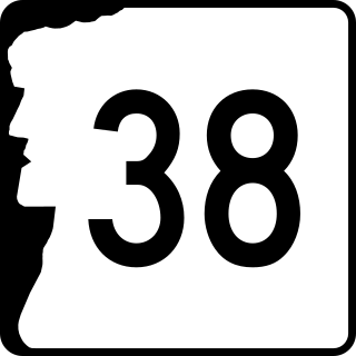
New Hampshire Route 38 is an 8.7-mile-long (14.0 km) north–south state highway in extreme southern New Hampshire. It is the main road connecting Pelham with Salem.

<span class="mw-page-title-main">Mammoth Road</span> North-south road in New England, U.S.

Mammoth Road is a north–south road in Massachusetts and New Hampshire. The road runs from its origin in Lowell, Massachusetts to its northern end in Hooksett, New Hampshire, a suburb of Manchester. The total length of the road is 29.3 miles (47.2 km). It was named "Mammoth" in the hope that the convenience of its directness and elimination of smaller connecting roads between thoroughfares would result in sufficient use and prestige as to "kill all the other roads".

<span class="mw-page-title-main">The Mall at Rockingham Park</span> Shopping mall in New Hampshire, United States

The Mall at Rockingham Park is the largest shopping mall in the state of New Hampshire, with 1,024,171 square feet (95,148.6 m2) of floor space. The mall is located in the town of Salem, about 30 miles (48 km) north of Boston. The mall is adjacent to Interstate 93 and the former Rockingham Park race track in Salem, and was the state's third shopping mall to be built. The mall now hosts 144 stores. The mall features the traditional retailers Macy's, JCPenney, and Dick's Sporting Goods. The mall is managed by Simon Property Group, which owns 28.2% of it. As of March 2015, the mall was Simon's highest grossing center, with annual sales of $2,105 per square foot.

<span class="mw-page-title-main">Canobie Lake</span>

Canobie Lake is a 375-acre (1.52 km2) body of water located in Rockingham County in southern New Hampshire, United States, in the towns of Salem and Windham. It is approximately 1.5 miles (2.4 km) long, and on average 0.4 miles (0.64 km) wide, though two arms of the lake combine to produce a width of 1 mile (1.6 km) at the lake's center. Canobie Lake Park, an amusement park, is located on the lake's east shore. The lake is the water supply for the town of Salem, New Hampshire.

<span class="mw-page-title-main">Massachusetts Route 97</span> State highway in Essex County, Massachusetts, US

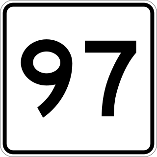
Route 97 is a south–north highway in Essex County in northeastern Massachusetts, United States. It connects the cities of Beverly and Haverhill before continuing into Salem, New Hampshire as New Hampshire Route 97.

<span class="mw-page-title-main">Manchester and Lawrence Railroad</span> Locomotive in new hampshire, USA

The Manchester and Lawrence Railroad was a railroad company that was chartered in New Hampshire, United States, by businessmen from Manchester, to build a rail line from that city to the Massachusetts state line.

<span class="mw-page-title-main">Merrimack Valley</span> Region in the U.S. states of New Hampshire and Massachusetts

The Merrimack Valley is a bi-state region along the Merrimack River in the U.S. states of New Hampshire and Massachusetts. The Merrimack is one of the larger waterways in New England and has helped to define the livelihood and culture of those living along it for millennia.

References

  1. "Town Council". Town of Salem, New Hampshire. Retrieved July 21, 2023.
  2. 1 2 "2021 U.S. Gazetteer Files – New Hampshire". United States Census Bureau. Retrieved January 3, 2022.
  3. "Census - Geography Profile: Salem town, Rockingham County, New Hampshire" . Retrieved January 3, 2022.
  4. "Salem, New Hampshire is No. 37 on Money's Best Places to Live list". Money. Retrieved November 15, 2021.
  5. Edgar Gilbert's History of Salem, N.H. (1907)
  6. Gilbert
  7. Seed, Douglas, & Khalife, Katherine (1996). Salem, NH. Volume II - Trolleys, Canobie Lake, and Rockingham Park, Images of America. Arcadia Publishing. ISBN   0-7524-0438-5.
  8. DeAngelis, Allison (April 11, 2018). "Large companies eye space in Salem's Tuscan Village". The Eagle-Tribune. Retrieved August 27, 2020.
  9. HNTB Corporation (2009). "I-93 Corridor Multi-Modal Transit Investment Study". http://www.rebuildingi93.com/content/taskForce/I-93%20Transit%20Study.pdf
  10. "Is there fluoride in the water?". Town of Salem New Hampshire. Town of Salem, NH. Retrieved May 12, 2015.
  11. "Census of Population and Housing". Census.gov. Retrieved June 4, 2016.
  12. "U.S. Census website". United States Census Bureau . Retrieved January 31, 2008.
  13. "Election Results". sos.nh.gov.
  14. "Best Places to Live in Salem, New Hampshire". www.bestplaces.net. Retrieved April 5, 2018.
  15. "Pamela Gidley". Legacy.com . Archived from the original on June 7, 2023. Retrieved June 7, 2023.
  16. "SUNUNU, John E. - Biographical Information". bioguide.congress.gov. Retrieved February 2, 2018.
  17. Axelrod, Tal (December 2018). "Ex-chief of staff mourns George H.W. Bush: 'I will miss a great friend'".