North Hampton, New Hampshire

Last updated

North Hampton, New Hampshire
Town Hall, 1844, North Hampton NH.jpg
North Hampton, NH Town Seal.png
Rockingham County New Hampshire incorporated and unincorporated areas North Hampton highlighted.svg
Location in Rockingham County and the state of New Hampshire.
Coordinates: 42°58′21″N70°49′47″W / 42.97250°N 70.82972°W / 42.97250; -70.82972
Country United States
State New Hampshire
County Rockingham
Incorporated November 30, 1742
Villages
  • North Hampton
  • North Hampton Center
  • Cemetery Corners
  • Fogg Corner
  • Little Boars Head
Government
   Select Board
  • Jonathan Pinette, Chair
  • Jim Maggiore
  • James Sununu
   Town Administrator Michael Tully
Area
[1]
  Total14.4 sq mi (37.3 km2)
  Land13.9 sq mi (36.0 km2)
  Water0.5 sq mi (1.3 km2)  3.46%
Elevation
79 ft (24 m)
Population
 (2020)
  Total4,538
  Density327/sq mi (126.2/km2)
Time zone UTC-5 (Eastern)
  Summer (DST) UTC-4 (Eastern)
ZIP code
03862
Area code 603
FIPS code 33-54580
GNIS feature ID0873687
Website www.northhampton-nh.gov

North Hampton is a town in Rockingham County, New Hampshire, United States. The population was 4,538 at the 2020 census. [2] While the majority of the town is inland, North Hampton includes a part of New Hampshire's limited Atlantic seacoast.

Contents

History

First settled in 1639, the town was a part of Hampton known as "North Hill" or "North Parish". Residents began petitioning for separation from Hampton as early as 1719, but township was not granted until 1742 by colonial governor Benning Wentworth, following separation of New Hampshire from Massachusetts.

Little Boar's Head, a seaside promontory, became a fashionable summer resort area in the 19th century, and contains elegant examples of late Victorian and Edwardian architecture. [3]

Geography

According to the United States Census Bureau, the town has a total area of 14.4 square miles (37.3 km2), of which 13.9 square miles (36.0 km2) are land and 0.50 square miles (1.3 km2) are water, comprising 3.46% of the town. [1] The highest point in North Hampton is the summit of Pine Hill, at 160 feet (49 m) above sea level, on the town's western border. The town is drained to the east by the Little River, which flows directly to the Atlantic Ocean, and to the northwest by the Winnicut River, which flows to Great Bay, which in turn reaches the Atlantic by way of the Piscataqua River.

U.S. Route 1 and state routes 1A and 151 run north–south through North Hampton, while 111 runs east–west. Interstate 95 runs through North Hampton without access to the town; Route 101 provides easier freeway access to North Hampton despite never entering the town. The nearest commercial airport is Portsmouth International Airport; the two closest major airports are Logan Airport in Boston and Portland International Jetport in Maine.

Adjacent municipalities

Demographics

Historical population
CensusPop.Note
1790 657
1800 653−0.6%
1810 651−0.3%
1820 76417.4%
1830 7670.4%
1840 88515.4%
1850 822−7.1%
1860 771−6.2%
1870 723−6.2%
1880 7747.1%
1890 8043.9%
1900 8121.0%
1910 782−3.7%
1920 677−13.4%
1930 6952.7%
1940 81817.7%
1950 1,10435.0%
1960 1,91073.0%
1970 3,25970.6%
1980 3,4255.1%
1990 3,6376.2%
2000 4,25917.1%
2010 4,3011.0%
2020 4,5385.5%
U.S. Decennial Census [4]

As of the census [5] of 2000, there were 4,259 people, 1,671 households, and 1,234 families residing in the town. The population density was 306.3 inhabitants per square mile (118.3/km2). There were 1,782 housing units at an average density of 128.1 per square mile (49.5/km2). The racial makeup of the town was 98.40% White, 0.31% African American, 0.05% Native American, 0.63% Asian, 0.21% from other races, and 0.40% from two or more races. Hispanic or Latino of any race were 0.77% of the population.

There were 1,671 households, out of which 29.8% had children under the age of 18 living with them, 64.6% were married couples living together, 7.0% had a female householder with no husband present, and 26.1% were non-families. 20.0% of all households were made up of individuals, and 8.3% had someone living alone who was 65 years of age or older. The average household size was 2.55 and the average family size was 2.96.

In the town, the population was spread out, with 23.3% under the age of 18, 4.4% from 18 to 24, 27.4% from 25 to 44, 30.5% from 45 to 64, and 14.3% who were 65 years of age or older. The median age was 42 years. For every 100 females, there were 95.3 males. For every 100 females age 18 and over, there were 94.3 males.

The median income for a household in the town was $66,696, and the median income for a family was $72,500. Males had a median income of $51,451 versus $31,512 for females. The per capita income for the town was $34,187. About 1.6% of families and 3.3% of the population were below the poverty line, including 0.7% of those under age 18 and 6.1% of those age 65 or over.

Notable people

Thoroughbreds

Sites of interest

Related Research Articles

<span class="mw-page-title-main">Rockingham County, New Hampshire</span> County in New Hampshire, United States

Rockingham County is a county in the U.S. state of New Hampshire. As of the 2020 census, the population was 314,176, making it New Hampshire's second-most populous county. The county seat is Brentwood. Rockingham County is part of the Boston-Cambridge-Newton, MA-NH Metropolitan Statistical Area and the greater Boston-Worcester-Providence, MA-RI-NH-CT Combined Statistical Area. Per the 2020 census, it was New Hampshire's fastest growing county from 2010 to 2020.

<span class="mw-page-title-main">Sanbornton, New Hampshire</span> Town in New Hampshire, United States

Sanbornton is a town in Belknap County, New Hampshire, United States. The population was 3,026 at the 2020 census. It includes the villages of North Sanbornton and Gaza.

<span class="mw-page-title-main">Errol, New Hampshire</span> Town in New Hampshire, United States

Errol is a town in Coös County, New Hampshire, United States. The population was 298 at the 2020 census. It is located north of the White Mountains along Route 16 at its intersection of Route 26. It has a municipal airport with a single, unpaved runway.

<span class="mw-page-title-main">Wentworth Location, New Hampshire</span> Township in Coos County, New Hampshire, United States

Wentworth Location is a township in Coös County, New Hampshire, United States. Its population was 28 at the 2020 census. It is part of the Berlin, NH-VT Micropolitan Statistical Area.

<span class="mw-page-title-main">Piermont, New Hampshire</span> Town in New Hampshire, United States

Piermont is a town in Grafton County, New Hampshire, United States. The population was 769 at the 2020 census. It is home to Camp Walt Whitman and Kingswood Camp for Boys.

<span class="mw-page-title-main">Chester, New Hampshire</span> Town in New Hampshire, United States

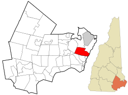
Chester is a town in Rockingham County, New Hampshire, United States. The population was 5,232 at the 2020 census, up from 4,768 at the 2010 census. It was home to the now defunct Chester College.

<span class="mw-page-title-main">Greenland, New Hampshire</span> Place in New Hampshire, United States

Greenland is a town in Rockingham County, New Hampshire, United States. The population was 4,067 at the 2020 census, up from 3,549 at the 2010 census. It is drained by the Winnicut River and bounded on the northwest by Great Bay.

<span class="mw-page-title-main">Hampstead, New Hampshire</span> Place in New Hampshire, United States

Hampstead is a town in Rockingham County, New Hampshire, United States. The population was 8,998 at the 2020 census. Hampstead, which includes the village of East Hampstead, is home to a portion of the Rockingham Recreational Trail.

<span class="mw-page-title-main">Newington, New Hampshire</span> Place in New Hampshire, United States

Newington is a town in Rockingham County, New Hampshire, United States. The population was 811 at the 2020 census. It is bounded to the west by Great Bay, to the northwest by Little Bay and to the northeast by the Piscataqua River.

<span class="mw-page-title-main">Northwood, New Hampshire</span> Place in New Hampshire, United States

Northwood is a town in Rockingham County, New Hampshire, United States. The population was 4,641 at the 2020 census.

<span class="mw-page-title-main">Rye, New Hampshire</span> Town in New Hampshire, United States

Rye is a town in Rockingham County, New Hampshire, United States. The population was 5,543 at the 2020 census. The town is home to several state parks along the Atlantic coastline.

<span class="mw-page-title-main">South Hampton, New Hampshire</span> Town in New Hampshire, United States

South Hampton is a town in Rockingham County, New Hampshire, United States. The population was 894 at the 2020 census. South Hampton is home to Cowden State Forest and Powwow River State Forest.

<span class="mw-page-title-main">Meredith (CDP), New Hampshire</span> Census-designated place in New Hampshire, United States

Meredith is a census-designated place (CDP) and the main village in the town of Meredith in Belknap County, New Hampshire, United States. The population was 2,527 at the 2020 census, out of 6,662 in the entire town of Meredith.

<span class="mw-page-title-main">Epping (CDP), New Hampshire</span> Census-designated place in New Hampshire, United States

Epping is a census-designated place (CDP) and the main village in the town of Epping, Rockingham County, New Hampshire, United States. The population of the CDP was 2,693 at the 2020 census, out of 7,125 in the entire town.

<span class="mw-page-title-main">Exeter (CDP), New Hampshire</span> Census-designated place in New Hampshire, United States

Exeter is a census-designated place (CDP) and the main village in the town of Exeter, Rockingham County, New Hampshire, United States. The population of the CDP was 10,109 at the 2020 census, out of 16,049 in the entire town.

<span class="mw-page-title-main">Hampton (CDP), New Hampshire</span> Census-designated place in New Hampshire, United States

Hampton is a census-designated place (CDP) comprising the town center and surrounding developed areas of the town of Hampton, Rockingham County, New Hampshire, United States. The population of the CDP was 9,597 at the 2020 census, out of 16,214 in the entire town.

<span class="mw-page-title-main">Hampton Beach, New Hampshire</span> Census-designated place in New Hampshire, United States

Hampton Beach is a village district, census-designated place, and beach resort in the town of Hampton, New Hampshire, United States, along the Atlantic Ocean. Its population at the 2020 census was 2,598. Hampton Beach is in Rockingham County, approximately 15 miles (24 km) south of Portsmouth. The community is a popular tourist destination and the busiest beach community in New Hampshire. Ocean Boulevard, the main street along the beach, includes a boardwalk, many shops and businesses, several seasonal hotels, and the Hampton Beach Casino Ballroom, which hosts national acts in the summer. Hampton Beach State Park was named one of four "Superstar" beaches in the United States in 2011, for having had perfect water-quality testing results in each of the previous three years.

New Hampton is a census-designated place (CDP) and the main village in the town of New Hampton in Belknap County, New Hampshire, United States. The population was 373 at the 2020 census, out of 2,377 people in the entire town of New Hampton.

<span class="mw-page-title-main">Seabrook Beach, New Hampshire</span> Census-designated place in New Hampshire, United States

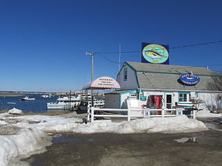
Seabrook Beach is a census-designated place in the town of Seabrook and partially in the town of Hampton in Rockingham County, New Hampshire, United States. It had a population of 1,078 at the 2020 census.

<span class="mw-page-title-main">Ashland (CDP), New Hampshire</span> Census-designated place in New Hampshire, United States

Ashland is a census-designated place (CDP) and the main village in the town of Ashland in Grafton County, New Hampshire, United States. The population of the CDP was 1,082 at the 2020 census, out of 1,938 in the entire town.

References

  1. 1 2 "2021 U.S. Gazetteer Files – New Hampshire". United States Census Bureau. Retrieved December 30, 2021.
  2. "Census - Geography Profile: North Hampton town, Rockingham County, New Hampshire" . Retrieved December 24, 2021.
  3. "NRHP nomination for Little Boar's Head Historic District". National Park Service. Retrieved July 4, 2014.
  4. "Census of Population and Housing". Census.gov. Retrieved June 4, 2016.
  5. "U.S. Census website". United States Census Bureau . Retrieved January 31, 2008.
  6. State Builders: An Illustrated Historical and Biographical Record of the State of New Hampshire, 1903
  7. "Congratulating Fuller". The Portsmouth Herald . Portsmouth, New Hampshire. September 10, 1924. p. 1. Retrieved June 30, 2019 via newspapers.com.
  8. Milne, John (June 21, 1987). "New breed of politician emerging in N.H." The Boston Globe . p. 50. Retrieved June 30, 2019 via newspapers.com.
  9. Kane, Amy (February 16, 2007). "Last remembrance of champion horse". seacoastonline.com. Retrieved June 30, 2019.