Rye, New Hampshire

Last updated

Rye, New Hampshire
Town
Jenness Beach in 2020.png
Rye, NH Town Seal.png
Rockingham County New Hampshire incorporated and unincorporated areas Rye highlighted.svg
Location in Rockingham County and the state of New Hampshire
Coordinates: 43°00′48″N70°46′15″W / 43.01333°N 70.77083°W / 43.01333; -70.77083
CountryUnited States
State New Hampshire
County Rockingham
Founded1623
Incorporated 1785
Villages
List
  • Rye
  • Rye Beach
  • Rye Harbor
  • Cable Road
  • Fairhill Manor
  • Foyes Corner
  • Langs Corner
  • West Rye
Government
   Select board
  • Tom King, Chair
  • Bill Epperson
  • Bob McGrath
  Town AdministratorMatt Scruton
Area
[1]
  Total36.8 sq mi (95.2 km2)
  Land12.6 sq mi (32.7 km2)
  Water24.1 sq mi (62.5 km2)  65.63%
Elevation
75 ft (23 m)
Population
 (2020)
  Total5,543
  Density438/sq mi (169.3/km2)
Time zone UTC−5 (Eastern)
  Summer (DST) UTC−4 (Eastern)
ZIP Codes
03870 (Rye)
03871 (Rye Beach)
Area code 603
FIPS code 33-66180
GNIS feature ID0873712
Website www.town.rye.nh.us

Rye is a town in Rockingham County, New Hampshire, United States. The population was 5,543 at the 2020 census. [2] The town is home to several state parks along the Atlantic coastline.

Contents

History

The first settlement in New Hampshire, originally named Pannaway Plantation, was established in 1623 at Odiorne's Point [3] by a group of fishermen led by David Thompson. The settlement was abandoned in favor of Strawbery Banke, which became Portsmouth. The first settler in present-day Rye was probably William Berry. [4] Prior to its incorporation in 1726 as a parish of New Castle, Rye was called "Sandy Beach" and its lands were once parts of New Castle, Portsmouth, Greenland and Hampton. [5] In 1726, the town of New Castle set off a parish for Sandy Beach called "Rye", for Rye in Sussex, England, the ancestral lands of the Jenness family who continue to live in the town to this day and even have a beach named after them. The town was incorporated in 1785. In 2013, a researcher pointed out that the town seal showed the parish creation date of 1726 as the incorporation date. [6] Later on in the year, the seal was updated to include the three dates important to Rye, 1623, 1726 and 1785.

1899 monument marking presumed landing place of 1623 1623landing.JPG
1899 monument marking presumed landing place of 1623

Geography

According to the United States Census Bureau, the town has a total area of 36.8 square miles (95.2 km2), of which 12.6 square miles (32.7 km2) are land and 24.1 square miles (62.5 km2) are water, comprising 65.63% of the town. [1] The town is located on the shore of the Atlantic Ocean and includes four of the nine islands known as the Isles of Shoals, which lie approximately 10 miles (16 km) out from the mainland. The highest point in Rye is the summit of Breakfast Hill, at 151 feet (46 m) above sea level, on the town's border with Greenland.

State parks in Rye along the Atlantic shoreline include (from south to north) Jenness State Beach, Rye Harbor State Park, Wallis Sands State Beach, and 135-acre (55 ha) Odiorne Point State Park, home to the Seacoast Science Center.

Route 1A, going north-south, follows the coast. Short segments of U.S. Route 1 and Route 1B pass through Rye. The nearest major highway is I-95, with the closest two exits in Hampton and Portsmouth. The nearest commercial airport is Portsmouth International Airport at Pease; the two closest major airports are Logan Airport in Boston and Portland International Jetport in Maine.

The village of Rye Beach is in the southern part of the town. Rye Beach has its own U.S. post office, as well as its own zoning enforcement and planning regulations. [7]

Rock formation near Odiorne Point Rye-NH-Rocks.png
Rock formation near Odiorne Point

Adjacent municipalities

Demographics

Historical population
CensusPop.Note
1790 865
1800 8902.9%
1810 1,02014.6%
1820 1,12710.5%
1830 1,1724.0%
1840 1,2052.8%
1850 1,2957.5%
1860 1,199−7.4%
1870 993−17.2%
1880 1,11111.9%
1890 978−12.0%
1900 1,14216.8%
1910 1,014−11.2%
1920 1,19617.9%
1930 1,081−9.6%
1940 1,24615.3%
1950 1,98259.1%
1960 3,24463.7%
1970 4,08325.9%
1980 4,50810.4%
1990 4,6122.3%
2000 5,18212.4%
2010 5,2982.2%
2020 5,5434.6%
U.S. Decennial Census [8]

As of the census of 2010, there were 5,298 people, 2,252 households, and 1,531 families residing in the town. There were 2,852 housing units, of which 600, or 21.0%, were vacant. 471 of the vacant units were for seasonal or vacation use. The racial makeup of the town was 97.8% white, 0.3% African American, 0.02% Native American, 0.9% Asian, 0.04% Native Hawaiian or Pacific Islander, 0.2% some other race, and 0.8% from two or more races. 1.1% of the population were Hispanic or Latino of any race. [9]

Of the 2,252 households, 26.3% had children under the age of 18 living with them, 56.3% were headed by married couples living together, 8.1% had a female householder with no husband present, and 32.0% were non-families. 25.4% of all households were made up of individuals, and 10.9% were someone living alone who was 65 years of age or older. The average household size was 2.34, and the average family size was 2.80. [9]

In the town, 20.3% of the population were under the age of 18, 4.3% were from 18 to 24, 18.2% from 25 to 44, 37.5% from 45 to 64, and 19.7% were 65 years of age or older. The median age was 48.8 years. For every 100 females, there were 95.1 males. For every 100 females age 18 and over, there were 93.8 males. [9]

For the period 2012–2016, the estimated median annual income for a household was $99,417, and the median income for a family was $122,064. Male full-time workers had a median income of $60,368 versus $50,588 for females. The per capita income for the town was $60,071. 5.1% of the population and 2.3% of families were below the poverty line. 4.4% of the population under the age of 18 and 5.6% of those 65 or older were living in poverty. [10]

Politics

As of September 1, 2021, 1,733 registered voters in Rye were registered as Democrats with 1,552 and 1,453 being registered as Republicans and undeclared, respectively. [11]

In August 2001, a group of townspeople from Newington and Rye made a plea in protest to the state legislature to consider allowing the town to secede from the state due to disproportionate property tax laws which had been passed by the state in 1997 to balance the state's education economy. [12] The dispute was largely quelled by the lack of support for the movement, as only 52 of Newington's 700+ (and 100 of Rye's 5,000) residents signed the petition. The property tax issue itself quieted as Governor Craig Benson announced in 2003 the property taxes would be cut almost by half by 2008.

Education

Children who live in Rye can attend public schools in town from kindergarten through eighth grade. School Administrative Unit 50 (SAU-50) is the school district that serves Rye, as well as the towns of Greenland, Newington, and New Castle. High school students from Rye attend Portsmouth High School.

Rye Elementary School is home to kindergarten through fifth grade and is the first and largest school students from Rye will attend in SAU-50. All grades are co-ed and the school has an 11 to 1 student per teacher ratio with three hundred and thirty students enrolled in October 2013. Rye Junior High handles grades six, seven, and eight. The neighboring town of New Castle sends its students to Rye Junior High after sixth grade, but only contributes a few students to each year's seventh grade class. All grades are coed and contain two hundred and twenty students as of October 2013 with a ratio of nine students to each teacher.

There are two private pre-schools in the town. Rye Country Day is the larger of the two pre-schools in town, currently enrolling one hundred and forty students (as of October 2013). The second, The Children's House Montessori school, is located at 80 Sagamore Road and has a student per teacher ratio of eleven to one.

Learning Skills Academy is a private non-profit school catering to students with learning capabilities. The organization has a location at 1237 Washington Road in Rye and accepts students in fifth through eleventh grade, as well as third. 32 kids make up the student body at the Rye location as of October 2013.

Notable people

Sites of interest

Parsons Homestead ParsonsHomestead.jpg
Parsons Homestead

The town has six structures listed on the National Register of Historic Places:

The Isles of Shoals are designated as a U.S. Historic District.

Rye was the setting (in part) of the short story "Marjorie Daw" by Thomas Bailey Aldrich (1836–1907). [16]

Related Research Articles

<span class="mw-page-title-main">Rockingham County, New Hampshire</span> County in New Hampshire, United States

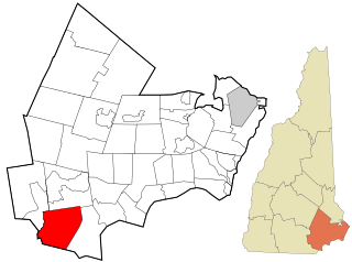
Rockingham County is a county in the U.S. state of New Hampshire. As of the 2020 census, the population was 314,176, making it New Hampshire's second-most populous county. The county seat is Brentwood. Rockingham County is part of the Boston-Cambridge-Newton, MA-NH Metropolitan Statistical Area and the greater Boston-Worcester-Providence, MA-RI-NH-CT Combined Statistical Area. Per the 2020 census, it was New Hampshire's fastest growing county from 2010 to 2020.

<span class="mw-page-title-main">Portsmouth, New Hampshire</span> City in Rockingham County, New Hampshire

Portsmouth is a city in Rockingham County, New Hampshire, United States. At the 2020 census it had a population of 21,956. A historic seaport and popular summer tourist destination on the Piscataqua River bordering the state of Maine, Portsmouth was formerly the home of the Strategic Air Command's Pease Air Force Base, since converted to Portsmouth International Airport at Pease.

<span class="mw-page-title-main">Brentwood, New Hampshire</span> Place in New Hampshire, United States

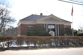
Brentwood is a town in Rockingham County, New Hampshire, United States. At the 2020 census, its population was 4,490. Brentwood has been the county seat of Rockingham County since 1997.

<span class="mw-page-title-main">Candia, New Hampshire</span> Place in New Hampshire, United States

Candia is a town in Rockingham County, New Hampshire, United States. The population was 4,013 at the 2020 census. The town includes the villages of Candia, Candia Four Corners and East Candia.

<span class="mw-page-title-main">Chester, New Hampshire</span> Town in New Hampshire, United States

Chester is a town in Rockingham County, New Hampshire, United States. The population was 5,232 at the 2020 census, up from 4,768 at the 2010 census. It was home to the now defunct Chester College.

<span class="mw-page-title-main">Deerfield, New Hampshire</span> Town in New Hampshire, United States

Deerfield is a town in Rockingham County, New Hampshire, United States. The population was 4,855 at the 2020 census, up from 4,280 in 2010. Deerfield is the location of the annual Deerfield Fair.

<span class="mw-page-title-main">Fremont, New Hampshire</span> American town

Fremont is a town in Rockingham County, New Hampshire, United States. The population was 4,739 at the 2020 census, up from 4,283 at the 2010 census. Fremont is crossed by the Rockingham Recreation Trail and NH Route 107.

<span class="mw-page-title-main">Greenland, New Hampshire</span> Place in New Hampshire, United States

Greenland is a town in Rockingham County, New Hampshire, United States. The population was 4,067 at the 2020 census, up from 3,549 at the 2010 census. It is drained by the Winnicut River and bounded on the northwest by Great Bay.

<span class="mw-page-title-main">New Castle, New Hampshire</span> Place in New Hampshire, United States

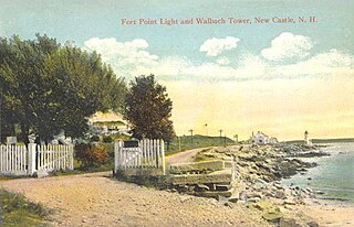
New Castle is a town in Rockingham County, New Hampshire, United States. The population was 1,000 at the 2020 census. It is the smallest and easternmost town in New Hampshire, and the only one located entirely on islands. It is home to Fort Constitution Historic Site, Fort Stark Historic Site, and the New Castle Common, a 31-acre (13 ha) recreation area on the Atlantic Ocean. New Castle is also home to a United States Coast Guard station, as well as the historic Wentworth by the Sea hotel.

<span class="mw-page-title-main">Newfields, New Hampshire</span> Place in New Hampshire, United States

Newfields is a town in Rockingham County, New Hampshire, United States. The population was 1,769 at the 2020 census. The primary village in town, where 378 people resided at the 2020 census, is defined as the Newfields census-designated place (CDP) and is located along New Hampshire Route 85 and the Squamscott River. It is a quaint village of handsome old houses.

<span class="mw-page-title-main">Newington, New Hampshire</span> Place in New Hampshire, United States

Newington is a town in Rockingham County, New Hampshire, United States. The population was 811 at the 2020 census. It is bounded to the west by Great Bay, to the northwest by Little Bay and to the northeast by the Piscataqua River.

<span class="mw-page-title-main">North Hampton, New Hampshire</span> Place in New Hampshire, United States

North Hampton is a town in Rockingham County, New Hampshire, United States. The population was 4,538 at the 2020 census. While the majority of the town is inland, North Hampton includes a part of New Hampshire's limited Atlantic seacoast.

<span class="mw-page-title-main">Stratham, New Hampshire</span> Town in New Hampshire, United States

Stratham is a town in Rockingham County, New Hampshire, United States. The town had a population of 7,669 at the 2020 census. It is bounded on the west by the Squamscott River. The town is the home of the only U.S. Lindt & Sprüngli factory and the headquarters of the Timberland Corporation.

<span class="mw-page-title-main">Windham, New Hampshire</span> Town in New Hampshire, United States

Windham is a suburban town in Rockingham County, New Hampshire, United States. The population at the 2020 census was 15,817, up from 13,592 in 2010.

<span class="mw-page-title-main">Exeter, New Hampshire</span> Town in New Hampshire, United States

Exeter is a town in Rockingham County, New Hampshire, United States. Its population was 16,049 at the 2020 census, up from 14,306 at the 2010 census. Exeter was the county seat until 1997, when county offices were moved to neighboring Brentwood. Home to Phillips Exeter Academy, a private university-preparatory school, Exeter is situated where the Exeter River becomes the tidal Squamscott River.

<span class="mw-page-title-main">Hampton, New Hampshire</span> Place in New Hampshire, United States

Hampton is a town in Rockingham County, New Hampshire, United States. The population was 16,214 at the 2020 census. On the Atlantic coast, Hampton is home to Hampton Beach, a summer tourist destination.

<span class="mw-page-title-main">Seacoast Region (New Hampshire)</span>

The Seacoast Region is the southeast area of the U.S. state of New Hampshire that is centered around the city of Portsmouth. It includes the eastern portion of Rockingham County and the southern portion of Strafford County. At its narrowest definition, the region stretches 13 miles (21 km) along the Atlantic Ocean from New Hampshire's border with Salisbury, Massachusetts, to the Piscataqua River and New Hampshire's border with Kittery, Maine. The shoreline alternates between rocky and rough headlands and areas with sandy beaches. Some of the beaches are bordered by jetties or groins, particularly in the towns of Rye and Hampton. Most definitions of the Seacoast Region includes some inland towns as well, including the Great Bay area cities of Dover and Rochester, the college town of Durham, and areas as far west as Epping. Some definitions also include nearby portions of York County, Maine that are culturally aligned with the Portsmouth area rather than the Portland, Maine metropolitan area.

<span class="mw-page-title-main">New Hampshire Route 1A</span> State highway in New Hampshire, US

New Hampshire Route 1A is an 18.32-mile (29.48 km) long state highway located in southeast New Hampshire. The route runs along the Atlantic coastline from the Massachusetts border north to Rye, then turns toward downtown Portsmouth. The southern terminus is at the Massachusetts state line in Seabrook where it continues south as Massachusetts Route 1A. The northern terminus is at a junction with U.S. Route 1 in downtown Portsmouth. For the length of the road's run along the shore, its local name is Ocean Boulevard. In the northern part of Rye, it is known as Pioneer Road, and in Portsmouth, it is known as Miller Avenue and Sagamore Avenue.

<span class="mw-page-title-main">New Hampshire Route 33</span> State highway in Rockingham County, New Hampshire, US

New Hampshire Route 33 is an 9.090-mile-long (14.629 km) east–west highway in the Seacoast Region of southeastern New Hampshire, connecting Stratham with Portsmouth. The western terminus is at New Hampshire Route 108 in Stratham. The eastern terminus is at U.S. Route 1 in downtown Portsmouth. It is a former routing of New Hampshire Route 101.

<span class="mw-page-title-main">Odiorne Point State Park</span> Public recreation area in New Hampshire, U.S.

Odiorne Point State Park is a public recreation area located on the Atlantic seacoast in the town of Rye near Portsmouth, New Hampshire, in the United States. Among the park's features are the Seacoast Science Center and the remains of the World War II Fort Dearborn. The park offers opportunities for hiking, cycling, picnicking, fishing, and boating.

References

Specific

  1. 1 2 "2021 U.S. Gazetteer Files – New Hampshire". United States Census Bureau. Retrieved January 3, 2022.
  2. "Census - Geography Profile: Rye town, Rockingham County, New Hampshire" . Retrieved December 24, 2021.
  3. Charles W. Brewster. "Old Pannaway: First NH Settlement". SeacoastNH.com. Retrieved August 1, 2008.
  4. Arthur H. Locke, A History and Genealogy of Captain John Locke, pg 2
  5. Langdon Parsons, History of the Town of Rye, pg 38
  6. Joey Cresta. "Town Seal ordeal in Rye". SeacoastNH.com. Retrieved January 3, 2022.
  7. "Rye Beach Village District" . Retrieved March 17, 2017.
  8. "Census of Population and Housing". Census.gov. Retrieved June 4, 2016.
  9. 1 2 3 "Profile of General Population and Housing Characteristics: 2010 Census Summary File 1 (DP-1): Rye town, Rockingham County, New Hampshire". American Factfinder. U.S. Census Bureau. Archived from the original on February 13, 2020. Retrieved February 7, 2018.
  10. "Selected Economic Characteristics: 2012-2016 American Community Survey 5-Year Estimates (DP03): Rye town, Rockingham County, New Hampshire". American Factfinder. U.S. Census Bureau. Archived from the original on February 13, 2020. Retrieved February 7, 2018.
  11. "NH-SOS - Party Registration/Names on Checklist History". sos.nh.gov. Retrieved November 15, 2021.
  12. Burnett, Carl (August 14, 2001). "Many N.H. towns protest taxes". The Dartmouth. Retrieved January 26, 2007.
  13. Carbone, Gina (July 27, 2008). "Release date reportedly set for Dan Brown's new book". Seacoast Online. Retrieved March 7, 2017.
  14. Leah Goldman (July 20, 2011). "Check Out The House Goldman Sachs Advisor Judd Gregg Is Trying To Sell For $4.9 Million". Business Insider. Retrieved May 7, 2012.
  15. "Chip Kelly named head coach".
  16. "Marjorie Daw" . Retrieved February 9, 2016.

General