Newton, New Hampshire

Last updated

Newton, New Hampshire
NewtonSeal.png
Rockingham County New Hampshire incorporated and unincorporated areas Newton highlighted.svg
Location in Rockingham County and the state of New Hampshire
Coordinates: 42°52′10″N71°02′04″W / 42.86944°N 71.03444°W / 42.86944; -71.03444
Country United States
State New Hampshire
County Rockingham
Incorporated 1749
Villages
Government
   Board of Selectmen
  • Robert Marchand Jr., Chair
  • Michael Connolly
  • Matthew Burrill
  • Daniel Guide
  • Joseph Simone
   Town Administrator Jim O'Mara (Interim)
Area
[1]
  Total10.0 sq mi (25.8 km2)
  Land9.8 sq mi (25.4 km2)
  Water0.2 sq mi (0.4 km2)  1.47%
Elevation
194 ft (59 m)
Population
 (2020)
  Total4,820
  Density491/sq mi (189.7/km2)
Time zone UTC-5 (Eastern)
  Summer (DST) UTC-4 (Eastern)
ZIP code
03858
Area code 603
FIPS code 33-52900
GNIS feature ID0873685
Website www.newton-nh.gov

Newton is a town in Rockingham County, New Hampshire, United States. The population was 4,820 at the 2020 census. [2]

Contents

History

A Victorian building in 1910 Victorian Building, Newton, NH.jpg
A Victorian building in 1910

The sixth town to be granted from the Masonian land purchase of 1746, Newton was originally part of Salisbury, Massachusetts; later, part of Amesbury, Massachusetts; then part of the West Parish of Amesbury; then part of New Town or South Hampton, Massachusetts (now South Hampton, New Hampshire). A number of the residents felt they were too far away from its church for their convenience, and the town was incorporated by colonial governor Benning Wentworth as "Newtown" in 1749, simply because it was a new town. In 1846, the New Hampshire legislature voted to contract the name to "Newton".

Geography

Newton is in southeastern New Hampshire, in southern Rockingham County. It is bordered to the south by the town of Merrimac in Massachusetts. According to the United States Census Bureau, the town has a total area of 10.0 square miles (25.8 km2), of which 9.8 square miles (25.4 km2) are land and 0.2 square miles (0.4 km2) are water, comprising 1.47% of the town. [1] The town is within the Merrimack River watershed, with the Little River draining the southwestern part of town, the East Meadow River draining the southern corner, and the Powwow River and its tributary the Back River draining the remainder. The highest point in Newton is the summit of Brandy Brow Hill, at 289 feet (88 m) above sea level, located directly upon the southern corner of the town.

Villages or place names in the town include Newton, Newton Junction, Rowes Corner, Sargent Corners, and Crane Crossing.

Adjacent municipalities

Demographics

Historical population
CensusPop.Note
1790 530
1800 450−15.1%
1810 4540.9%
1820 4775.1%
1830 5106.9%
1840 5416.1%
1850 68526.6%
1860 85024.1%
1870 8560.7%
1880 1,60687.6%
1890 1,064−33.7%
1900 924−13.2%
1910 9624.1%
1920 872−9.4%
1930 848−2.8%
1940 9006.1%
1950 1,17330.3%
1960 1,41921.0%
1970 1,92035.3%
1980 3,06859.8%
1990 3,47313.2%
2000 4,28923.5%
2010 4,6037.3%
2020 4,8204.7%
U.S. Decennial Census [3]

As of the census [4] of 2000, there were 4,289 people, 1,518 households, and 1,170 families residing in the town. The population density was 433.0 inhabitants per square mile (167.2/km2). There were 1,552 housing units at an average density of 156.7 per square mile (60.5/km2). The racial makeup of the town was 97.90% White, 0.68% African American, 0.16% Native American, 0.07% Asian, 0.02% Pacific Islander, 0.40% from other races, and 0.77% from two or more races. Hispanic or Latino of any race were 1.31% of the population.

There were 1,518 households, out of which 40.7% had children under the age of 18 living with them, 66.1% were married couples living together, 7.2% had a female householder with no husband present, and 22.9% were non-families. 15.8% of all households were made up of individuals, and 5.6% had someone living alone who was 65 years of age or older. The average household size was 2.83 and the average family size was 3.19.

In the town, the population was spread out, with 28.8% under the age of 18, 5.8% from 18 to 24, 36.2% from 25 to 44, 21.6% from 45 to 64, and 7.6% who were 65 years of age or older. The median age was 35 years. For every 100 females, there were 99.1 males. For every 100 females age 18 and over, there were 98.1 males.

The median income for a household in the town was $60,972, and the median income for a family was $62,271. Males had a median income of $43,510 versus $32,471 for females. The per capita income for the town was $22,910. About 2.7% of families and 4.0% of the population were below the poverty line, including 3.4% of those under age 18 and 16.0% of those age 65 or over.

Notable people

Sites of interest

Related Research Articles

<span class="mw-page-title-main">Rockingham County, New Hampshire</span> County in New Hampshire, United States

Rockingham County is a county in the U.S. state of New Hampshire. As of the 2020 census, the population was 314,176, making it New Hampshire's second-most populous county. The county seat is Brentwood. Rockingham County is part of the Boston-Cambridge-Newton, MA-NH Metropolitan Statistical Area and the greater Boston-Worcester-Providence, MA-RI-NH-CT Combined Statistical Area. Per the 2020 census, it was New Hampshire's fastest growing county from 2010 to 2020.

<span class="mw-page-title-main">Merrimac, Massachusetts</span> Town in Massachusetts, United States

Merrimac is a small town in Essex County, Massachusetts, United States, located on the southeastern border of New Hampshire, approximately 34 miles (55 km) northeast of Boston and 10 miles (16 km) west of the Atlantic Ocean. It was incorporated on April 11, 1876. It is situated along the north bank of the Merrimack River in the Merrimack Valley. The population was 6,723 at the 2020 census. Historically a mill town, it has long since become a largely residential community. It is part of the Greater Boston metropolitan area.

<span class="mw-page-title-main">Effingham, New Hampshire</span> Town in New Hampshire, United States

Effingham is a town in Carroll County, New Hampshire, United States. At the 2020 census, the town population was 1,691, up from 1,465 at the 2010 census. Effingham includes the villages of Effingham Falls, Effingham, Center Effingham, and South Effingham. Pine River State Forest is in the south.

<span class="mw-page-title-main">Warner, New Hampshire</span> Town in New Hampshire, United States

Warner is a town in Merrimack County, New Hampshire, United States. The population was 2,937 at the 2020 census. The town is home to Magdalen College of the Liberal Arts, Rollins State Park and Mount Kearsarge State Forest.

<span class="mw-page-title-main">Chester, New Hampshire</span> Town in New Hampshire, United States

Chester is a town in Rockingham County, New Hampshire, United States. The population was 5,232 at the 2020 census, up from 4,768 at the 2010 census. It was home to the now defunct Chester College.

<span class="mw-page-title-main">East Kingston, New Hampshire</span> Place in New Hampshire, United States

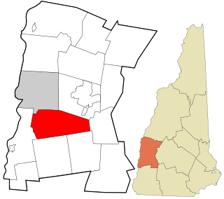
East Kingston is a town in Rockingham County, New Hampshire, United States. The population was 2,441 at the 2020 census.

<span class="mw-page-title-main">Greenland, New Hampshire</span> Place in New Hampshire, United States

Greenland is a town in Rockingham County, New Hampshire, United States. The population was 4,067 at the 2020 census, up from 3,549 at the 2010 census. It is drained by the Winnicut River and bounded on the northwest by Great Bay.

<span class="mw-page-title-main">Hampstead, New Hampshire</span> Place in New Hampshire, United States

Hampstead is a town in Rockingham County, New Hampshire, United States. The population was 8,998 at the 2020 census. Hampstead, which includes the village of East Hampstead, is home to a portion of the Rockingham Recreational Trail.

<span class="mw-page-title-main">Kensington, New Hampshire</span> Place in New Hampshire, United States

Kensington is a town in Rockingham County, New Hampshire, United States. The population was 2,095 at the 2020 census.

<span class="mw-page-title-main">Kingston, New Hampshire</span> Place in New Hampshire, United States

Kingston is a town in Rockingham County, New Hampshire, United States. The population at the 2020 census was 6,202.

<span class="mw-page-title-main">North Hampton, New Hampshire</span> Place in New Hampshire, United States

North Hampton is a town in Rockingham County, New Hampshire, United States. The population was 4,538 at the 2020 census. While the majority of the town is inland, North Hampton includes a part of New Hampshire's limited Atlantic seacoast.

<span class="mw-page-title-main">Plaistow, New Hampshire</span> Place in New Hampshire, United States

Plaistow is a town in Rockingham County, New Hampshire, United States. The population was 7,830 at the 2020 census.

<span class="mw-page-title-main">Sandown, New Hampshire</span> Town in New Hampshire, United States

Sandown is a town in Rockingham County, New Hampshire, United States. The population was 6,548 at the 2020 census, up from 5,986 at the 2010 census.

<span class="mw-page-title-main">Seabrook, New Hampshire</span> Town in New Hampshire, United States

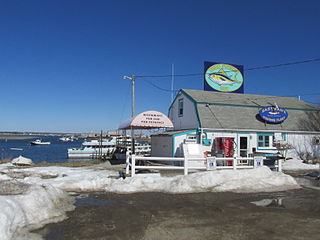
Seabrook is a town in Rockingham County, New Hampshire, United States. The population was 8,401 at the 2020 census. Located at the southern end of the coast of New Hampshire, on the border with Massachusetts, Seabrook is noted as the location of the Seabrook Station Nuclear Power Plant, the third-most recently constructed nuclear power plant in the United States.

<span class="mw-page-title-main">South Hampton, New Hampshire</span> Town in New Hampshire, United States

South Hampton is a town in Rockingham County, New Hampshire, United States. The population was 894 at the 2020 census. South Hampton is home to Cowden State Forest and Powwow River State Forest.

<span class="mw-page-title-main">Unity, New Hampshire</span> Place in New Hampshire, United States

Unity is a town in Sullivan County, New Hampshire, United States. The population was 1,518 at the 2020 census, down from 1,671 at the 2010 census. The town includes the villages of Unity, East Unity, Quaker City, and West Unity.

<span class="mw-page-title-main">Amesbury, Massachusetts</span> City in Massachusetts, United States

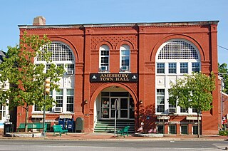
Amesbury is a city in Essex County, Massachusetts, United States, located on the left bank of the Merrimack River near its mouth, upstream from Salisbury and across the river from Newburyport and West Newbury. The population was 17,366 at the 2020 United States Census. A former farming and mill town, Amesbury is today largely residential. It is one of the two northernmost towns in Massachusetts.

<span class="mw-page-title-main">Hampton, New Hampshire</span> Place in New Hampshire, United States

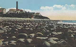
Hampton is a town in Rockingham County, New Hampshire, United States. The population was 16,214 at the 2020 census. On the Atlantic coast, Hampton is home to Hampton Beach, a summer tourist destination.

<span class="mw-page-title-main">Londonderry (CDP), New Hampshire</span> Census-designated place in New Hampshire, United States

Londonderry is a census-designated place (CDP) within the town of Londonderry in Rockingham County, New Hampshire, United States. The population of the CDP was 11,645 at the 2020 census, out of 25,826 in the entire town.

<span class="mw-page-title-main">Seabrook Beach, New Hampshire</span> Census-designated place in New Hampshire, United States

Seabrook Beach is a census-designated place in the town of Seabrook and partially in the town of Hampton in Rockingham County, New Hampshire, United States. It had a population of 1,078 at the 2020 census.

References

  1. 1 2 "2021 U.S. Gazetteer Files – New Hampshire". United States Census Bureau. Retrieved December 30, 2021.
  2. "Census - Geography Profile: Newton town, Rockingham County, New Hampshire" . Retrieved December 24, 2021.
  3. "Census of Population and Housing". Census.gov. Retrieved June 4, 2016.
  4. "U.S. Census website". United States Census Bureau . Retrieved January 31, 2008.
  5. Zhe, Mike (July 24, 2005). "NHL's new financial structure has local players job hunting in Europe". Seacoastonline. Retrieved December 30, 2021.
  6. Williams, Dave. "Mike Ryan". Society for American Baseball Research. Retrieved June 10, 2017.
  7. "Newton Historical Society" . Retrieved August 11, 2014.