
Rockingham County is a county in the U.S. state of New Hampshire. As of the 2020 census, the population was 314,176, making it New Hampshire's second-most populous county. The county seat is Brentwood. Rockingham County is part of the Boston-Cambridge-Newton, MA-NH Metropolitan Statistical Area and the greater Boston-Worcester-Providence, MA-RI-NH-CT Combined Statistical Area. Per the 2020 census, it was New Hampshire's fastest growing county from 2010 to 2020.

New Salem is a town in Franklin County, Massachusetts, United States. The population was 983 at the 2020 census. It is part of the Springfield, Massachusetts Metropolitan Statistical Area.

Pelham is a town in Hampshire County, Massachusetts, United States. The population was 1,280 at the 2020 census. Its ZIP Code is shared with Amherst.
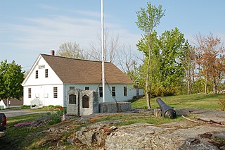
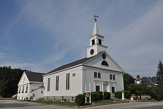
Lyndeborough is a town in Hillsborough County, New Hampshire, United States. The population was 1,702 at the 2020 census.
Pelham is a town in Hillsborough County, New Hampshire, United States. The population was 14,222 at the 2020 census, up from 12,897 at the 2010 census.

Plaistow is a town in Rockingham County, New Hampshire, United States. The population was 7,830 at the 2020 census.

Salem is a town in Rockingham County, New Hampshire, United States. The population was 30,089 at the 2020 census and an estimated 30,647 in 2022. Salem is a northern suburb of Boston located on Interstate 93. As the first town along I-93 northbound in New Hampshire, which lacks any state sales tax, Salem has grown into a regional commercial hub for many nearby Massachusetts towns, anchored by the Mall at Rockingham Park and Tuscan Village. Other major sites include Canobie Lake Park, a large amusement park; and America's Stonehenge, a stone structure of disputed origins. It is the former home of Rockingham Park, a horse racetrack. The Sununu political family hails from Salem, including former New Hampshire governor and White House Chief of Staff John H. Sununu, and his sons John E. Sununu, a former U.S. senator, and Chris Sununu, current New Hampshire governor.
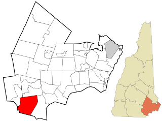
Windham is a suburban town in Rockingham County, New Hampshire, United States. The population at the 2020 census was 15,817, up from 13,592 in 2010.

Danvers is a town in Essex County, Massachusetts, United States, located on the Danvers River near the northeastern coast of Massachusetts. The suburb is a fairly short ride from Boston and is also in close proximity to the beaches of Gloucester and Revere. Originally known as Salem Village, the town is most widely known for its association with the 1692 Salem witch trials. It was also the site of Danvers State Hospital, one of the state's 19th-century psychiatric hospitals. Danvers is a local center of commerce, hosting many car dealerships and the Liberty Tree Mall. As of the 2020 United States Census, the town's population was 28,087.

Meredith is a town in Belknap County, New Hampshire, United States. The population was 6,662 at the 2020 census. Meredith is situated in the state's Lakes Region and serves as a major resort town. Meredith Village, the commercial center of the town, lies long the shores of Lake Winnipesaukee, and several other large lakes lie partially or completely within the town borders. It is home to the Stonedam Island Natural Area and the Winnipesaukee Scenic Railroad, and it serves as one of the ports of call for the MS Mount Washington.

Derry is a town in Rockingham County, New Hampshire, United States. The population was 34,317 at the 2020 census. Although it is a town and not a city, Derry is the most populous community in Rockingham County and the fourth most populous in the state. The town's nickname, "Spacetown", derives from the fact that Derry is the birthplace of Alan Shepard, the first astronaut from the United States in space. Derry was also for a time the home of the poet Robert Frost and his family.
Wilton is a town in Hillsborough County, New Hampshire, United States. The population was 3,896 at the 2020 census. Like many small New England towns, it grew up around water-powered textile mills, but is now a rural bedroom community with some manufacturing and service employment. Wilton is home to the High Mowing School, a private preparatory school.
A township in some states of the United States is a small geographic area.

The North Shore is a region in the U.S. state of Massachusetts, loosely defined as the coastal area between Boston and New Hampshire. The region is made up both of a rocky coastline, dotted with marshes and wetlands, as well as several beaches and natural harbors. The North Shore is an important historical, cultural, and economic region of Massachusetts. The southern part of the region includes Boston's densely populated inner northeast suburbs, including Salem. At the center of the North Shore lies its most prominent geographic feature, Cape Ann, with numerous small fishing towns, and at the northern end lies the Merrimack Valley, which was a major locus of the Industrial Revolution in the United States.

Greater Boston is the metropolitan region of New England encompassing the municipality of Boston, the capital of the U.S. state of Massachusetts and the most populous city in New England, and its surrounding areas. The region forms the northern arc of the Northeast megalopolis, making Greater Boston both a metropolitan statistical area (MSA) and a combined statistical area (CSA). The MSA consists of most of the eastern third of Massachusetts, excluding the South Coast and Cape Cod; the CSA additionally includes the municipalities of Providence, the capital of Rhode Island, Manchester, the largest city in New Hampshire, Worcester, the second-largest city in Massachusetts and in New England), the South Coast region, and Cape Cod. While the city of Boston covers 48.4 square miles (125 km2) and has 675,647 residents as of the 2020 census, the urbanization has extended well into surrounding areas and the CSA has a population of more than 8.4 million people, making it one of the most populous such regions in the U.S. The CSA is one of two in Massachusetts; the other is Greater Springfield. Greater Boston is the only CSA in New England that lies in three states, Massachusetts, New Hampshire, and Rhode Island. By some definitions, it extends into two additional states, Connecticut and Maine.

The Quabbin Valley is a region of Massachusetts in the United States. The region consists of the Quabbin Reservoir and accompanying river systems in Franklin, Hampden, Hampshire, and Worcester counties. The area is sometimes known as the Swift River Valley region, a reference to the Swift River, which was dammed to form the reservoir.

Canobie Lake is a 375-acre (1.52 km2) body of water located in Rockingham County in southern New Hampshire, United States, in the towns of Salem and Windham. It is approximately 1.5 miles (2.4 km) long, and on average 0.4 miles (0.64 km) wide, though two arms of the lake combine to produce a width of 1 mile (1.6 km) at the lake's center. Canobie Lake Park, an amusement park, is located on the lake's east shore. The lake is the water supply for the town of Salem, New Hampshire.
Route 97 is a south–north highway in Essex County in northeastern Massachusetts, United States. It connects the cities of Beverly and Haverhill before continuing into Salem, New Hampshire as New Hampshire Route 97.

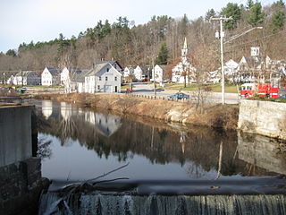
The Merrimack Valley is a bi-state region along the Merrimack River in the U.S. states of New Hampshire and Massachusetts. The Merrimack is one of the larger waterways in New England and has helped to define the livelihood and culture of those living along it for millennia.


