Auburn, New Hampshire

Last updated

Auburn, New Hampshire
Massabesic Lake-Postcard-1920.jpg
Massabesic Lake and the east shore in 1920
Auburn, NH Town Seal.png
Rockingham County New Hampshire incorporated and unincorporated areas Auburn highlighted.svg
Location in Rockingham County and the state of New Hampshire.
Coordinates: 43°00′16″N71°20′54″W / 43.00444°N 71.34833°W / 43.00444; -71.34833
Country United States
State New Hampshire
County Rockingham
Incorporated 1845
Villages
  • Auburn
  • Severance
Government
   Board of Selectmen
  • Keith N. Leclair, Chair
  • Michael J. Rolfe
  • Thomas F. Carroll
  Town AdministratorChris Sterndale
Area
[1]
  Total28.81 sq mi (74.62 km2)
  Land25.35 sq mi (65.66 km2)
  Water3.46 sq mi (8.96 km2)  12.01%
Elevation
253 ft (77 m)
Population
 (2020) [2]
  Total5,946
  Density235/sq mi (90.6/km2)
Time zone UTC-5 (Eastern)
  Summer (DST) UTC-4 (Eastern)
ZIP code
03032
Area code 603
FIPS code 33-02820
GNIS feature ID0873536
Website www.auburnnh.us

Auburn is a town in Rockingham County, New Hampshire, United States. The population was 5,946 at the 2020 census, [2] up from 4,953 at the 2010 census.

Contents

History

Auburn was originally settled by Native Americans in 1624. It was a fishing settlement called by Native Americans "Massabesic" (the current name of the town's largest lake). British settlers arrived in the area in 1720 and made peace with the Natives until the French and Indian War. The Massabesic settlement was destroyed, and the nearby town of Chester claimed the land. It was known as "Chester Woods", "Chester West Parish", "Long Meadow", [3] and then Auburn. Auburn became an independent town on June 25, 1845, [3] with a population of 1,200 people. As with Auburn, Maine, Auburn, Massachusetts, and Auburn, New York, the name is from Oliver Goldsmith's popular 18th-century poem, "The Deserted Village", which begins:

Sweet Auburn! loveliest village of the plain,
Where health and plenty cheered the labouring swain
Where smiling spring its earliest visit paid,
And parting summer's lingering blooms delayed

Auburn was served by the Concord and Portsmouth Railroad, which later became the Portsmouth Branch of the Boston & Maine Railroad. [3] Auburn was home to a small passenger depot at one time, but by the mid 1900s most rail activity was through traffic, as Auburn had few on-line industries. The last freight trains passed through in the early 1980s. The track was abandoned in 1982 and subsequently torn up between 1983 and 1985.

Geography

According to the United States Census Bureau, the town has a total area of 28.8 square miles (74.6 km2), of which 25.4 square miles (65.7 km2) are land and 3.5 square miles (9.0 km2), or 12.01%, are water. [1] Massabesic Lake, located in the western part of Auburn and the eastern part of Manchester, is the largest body of water in Auburn and serves as the public water supply for Manchester. The lake is fed by numerous tributaries, most notable being Sucker Brook, which enters the northeastern end of the lake near the Auburn town center and itself drains several lakes, including Tower Hill Pond, Clark Pond, and Little Massabesic Lake. Cohas Brook flows through the eastern portion of Auburn and eventually (in Manchester) receives the outflow of Massabesic Lake before flowing west to the Merrimack River. Auburn lies fully within the Merrimack River watershed. [4] Three hills, all overlooking Massabesic Lake, can lay potential claim to being Auburn's highest point: Mount Miner, at 582 feet (177 m) above sea level, located north of the lake; Mine Hill, greater than 580 ft (180 m), above the east shore; and Mount Misery, greater than 580 feet, to the southeast.

Adjacent municipalities

Climate

According to the Köppen Climate Classification system, Auburn has a warm-summer humid continental climate, abbreviated "Dfb" on climate maps. The hottest temperature recorded in Auburn was 105 °F (40.6 °C) on August 3, 1988, while the coldest temperature recorded was −43 °F (−41.7 °C) on February 16, 1943. [5]

Climate data for Auburn, New Hampshire (Massabesic Lake), 1991–2020 normals, extremes 1942–present
MonthJanFebMarAprMayJunJulAugSepOctNovDecYear
Record high °F (°C)67
(19)
74
(23)
86
(30)
94
(34)
95
(35)
98
(37)
100
(38)
105
(41)
96
(36)
88
(31)
81
(27)
78
(26)
105
(41)
Mean maximum °F (°C)53.6
(12.0)
55.4
(13.0)
65.3
(18.5)
80.0
(26.7)
87.8
(31.0)
91.3
(32.9)
92.7
(33.7)
91.5
(33.1)
88.0
(31.1)
76.9
(24.9)
67.3
(19.6)
58.3
(14.6)
94.5
(34.7)
Mean daily maximum °F (°C)31.7
(−0.2)
34.8
(1.6)
42.9
(6.1)
56.1
(13.4)
67.1
(19.5)
76.0
(24.4)
81.1
(27.3)
79.8
(26.6)
72.9
(22.7)
59.7
(15.4)
48.3
(9.1)
37.5
(3.1)
57.3
(14.1)
Daily mean °F (°C)22.3
(−5.4)
24.9
(−3.9)
33.2
(0.7)
45.5
(7.5)
56.5
(13.6)
65.8
(18.8)
71.0
(21.7)
69.4
(20.8)
62.3
(16.8)
49.6
(9.8)
39.4
(4.1)
29.1
(−1.6)
47.4
(8.6)
Mean daily minimum °F (°C)13.0
(−10.6)
15.0
(−9.4)
23.6
(−4.7)
34.9
(1.6)
45.9
(7.7)
55.6
(13.1)
60.9
(16.1)
59.1
(15.1)
51.7
(10.9)
39.5
(4.2)
30.4
(−0.9)
20.8
(−6.2)
37.5
(3.1)
Mean minimum °F (°C)−9.0
(−22.8)
−6.3
(−21.3)
2.1
(−16.6)
20.6
(−6.3)
30.0
(−1.1)
41.3
(5.2)
48.7
(9.3)
46.9
(8.3)
35.1
(1.7)
24.9
(−3.9)
15.0
(−9.4)
1.4
(−17.0)
−11.1
(−23.9)
Record low °F (°C)−35
(−37)
−43
(−42)
−22
(−30)
4
(−16)
16
(−9)
29
(−2)
33
(1)
32
(0)
12
(−11)
12
(−11)
−4
(−20)
−25
(−32)
−43
(−42)
Average precipitation inches (mm)2.67
(68)
2.70
(69)
3.19
(81)
3.49
(89)
3.37
(86)
4.27
(108)
3.65
(93)
3.68
(93)
3.87
(98)
4.36
(111)
3.49
(89)
3.77
(96)
42.51
(1,081)
Average snowfall inches (cm)15.9
(40)
17.6
(45)
6.7
(17)
0.9
(2.3)
0.0
(0.0)
0.0
(0.0)
0.0
(0.0)
0.0
(0.0)
0.0
(0.0)
0.0
(0.0)
1.1
(2.8)
10.6
(27)
52.8
(134.1)
Average precipitation days (≥ 0.01 in)8.77.27.99.810.710.59.59.48.710.18.89.2110.5
Average snowy days (≥ 0.1 in)5.24.32.60.30.00.00.00.00.00.00.53.116.0
Source 1: NOAA [6]
Source 2: National Weather Service [5]

Demographics

Historical population
CensusPop.Note
1840 869
1850 810−6.8%
1860 8869.4%
1870 815−8.0%
1880 719−11.8%
1890 631−12.2%
1900 6828.1%
1910 637−6.6%
1920 6522.4%
1930 73512.7%
1940 8079.8%
1950 1,15843.5%
1960 1,29211.6%
1970 2,03557.5%
1980 2,88341.7%
1990 4,08541.7%
2000 4,68214.6%
2010 4,9535.8%
2020 5,94620.0%
U.S. Decennial Census [2] [7]

As of the census [8] of 2000, there were 4,682 people, 1,580 households, and 1,322 families residing in the town. The population density was 185.7 inhabitants per square mile (71.7/km2). There were 1,622 housing units at an average density of 64.3 per square mile (24.8/km2). The racial makeup of the town was 98.29% White, 0.21% African American, 0.23% Native American, 0.41% Asian, 0.23% from other races, and 0.62% from two or more races. Hispanic or Latino of any race were 0.94% of the population.

There were 2,349 households, out of which 44.4% had children under the age of 18 living with them, 75.1% were married couples living together, 5.2% had a female householder with no husband present, and 16.3% were non-families. 11.8% of all households were made up of individuals, and 3.3% had someone living alone who was 65 years of age or older. The average household size was 2.96 and the average family size was 3.22.

In the town, the population was spread out, with 28.9% under the age of 18, 6.2% from 18 to 24, 33.0% from 25 to 44, 25.8% from 45 to 64, and 6.1% who were 65 years of age or older. The median age was 37 years. For every 100 females, there were 103.6 males. For every 100 females age 18 and over, there were 103.2 males.

The median income for a household in the town was $70,774, and the median income for a family was $72,578. Males had a median income of $45,000 versus $33,365 for females. The per capita income for the town was $28,405. About 1.6% of families and 1.8% of the population were below the poverty line, including 0.7% of those under age 18 and 11.2% of those age 65 or over.

Since Auburn has an agreement with the city of Manchester that the city and the surrounding towns can use Massabesic Lake as a water source, Manchester, Chester, Candia, Hooksett and Derry pay Auburn an estimated $3 million for Lake Massabesic.[ citation needed ]

Attractions

Lake Massabesic covers over 2,500 acres (1,000 ha) in Auburn and Manchester and serves as the public water supply for the city of Manchester. Half of the lake (the half farthest from the public water intake) is used for less-intrusive types of boating. No swimming or other contact between users and water is allowed. [9] Devil's Den is a small cave east of Massabesic Lake. The Massabesic Audubon Center is in central Auburn, occupying Battery Point on the lake. [10] The Griffin Mill Dam along Little Massabesic Brook-Sucker Brook is in the northeastern part of the town.

Events and festivals

Lake Massabesic Duck Race

Every year, the Auburn Historical Association hosts an annual Duck Race on Hooksett Road near a river that flows into Lake Massabesic. The main event starts at the Hooksett road bridge over the Little Massabesic Brook-Sucker Brook where a truck dumps thousands of yellow rubber ducks into the brook,lined with straight yellow floating tubes, and the race ends at a finish line on the left side of the Griffin Mill Bridge, past the waterfall. People buy individual ducks, with prizes going to the owners of the "fastest" ducks to reach the finish line. The event attracts thousands of onlookers each year, to partake in the selection of goods offered at rented booths and/or to watch the ducks leisurely float down the river. There are games for younger kids (usually provided by Auburn Village School volunteers). Visitors are able to access the Griffin Free Public Library, or browse the related booths parked in the Griffin Free Public Library's parking lot. An official pie contest happens at a booth in the Duck race, with 1st, 2nd,and 3rd place winner's getting special clay pie trays.

Yacht Sail Boating Club race

Every Sunday, sometimes also during the week, the Yacht Sail Boating Club hosts a sailboat race. Members of the club start on the northern shore of Massabesic Lake, and it ends after going 3 laps around the lake. Many visitors enjoy watching the races from their kayaks, sailboats, and canoes, or at Battery Point, the northernmost point on the Massabesic Peninsula.

Book sale

The last weekend in July, the Griffin Free Public Library holds a huge book sale at the Auburn Village School. Approximately 10,000 books and games are sold, with all proceeds benefiting the library's programs.

Education

Auburn is part of School Administrative Unit 15, along with the neighboring towns of Hooksett and Candia. SAU-15 administers five schools with Auburn Village School, serving all elementary school and middle school students (grades K–8) in the town. [11]

SAU-15 has no high school; students from Auburn attend high school at Pinkerton Academy (in Derry). [12]

Previously Auburn students attended high school in the Manchester School District, with the vast majority going to Manchester Memorial High School. In 2011, the town voted to change its high school to Pinkerton, with 1,119 in favor and 190 opposing. In 2011 some Auburn students already chose to go to Pinkerton. [13]

Transportation

Three state highways pass through the town. New Hampshire Route 101 is a four-lane expressway that passes through the northern part of the town, leading west to neighboring Manchester and east to Exeter. Access to Auburn is from Exit 2 within the town and Exit 1 just west of the town. New Hampshire Route 28 Bypass travels through the west side of Auburn, leading south to Derry and north to Hooksett. NH 28 Bypass intersects NH 101 at that highway's Exit 1. New Hampshire Route 121 passes through the center of Auburn, leading east to Chester.

There is one private airstrip, Cleary Airport (29NH) located at 33 Bunker Hill Road. The airport has one grass/sod runway 18/36 measuring approximately 3,200 by 60 feet (975 by 18 m). [14] [15]

Notable people

Related Research Articles

<span class="mw-page-title-main">Rockingham County, New Hampshire</span> County in New Hampshire, United States

Rockingham County is a county in the U.S. state of New Hampshire. As of the 2020 census, the population was 314,176, making it New Hampshire's second-most populous county. The county seat is Brentwood. Rockingham County is part of the Boston-Cambridge-Newton, MA-NH Metropolitan Statistical Area and the greater Boston-Worcester-Providence, MA-RI-NH-CT Combined Statistical Area. Per the 2020 census, it was New Hampshire's fastest growing county from 2010 to 2020.

<span class="mw-page-title-main">Merrimack County, New Hampshire</span> County in New Hampshire, United States

Merrimack County is a county in the U.S. state of New Hampshire. As of the 2020 Census, the population was 153,808, making it the third most populous county in New Hampshire. Its county seat is Concord, the state capital. The county was organized in 1823 from parts of Hillsborough and Rockingham counties, and is named for the Merrimack River. Merrimack County comprises the Concord, NH Micropolitan Statistical Area, which in turn constitutes a portion of the Boston–Worcester–Providence, MA–RI–NH–CT Combined Statistical Area. In 2010, the center of population of New Hampshire was located in Merrimack County, in the town of Pembroke.

<span class="mw-page-title-main">Waterboro, Maine</span> Town in Maine, United States

Waterboro is a town in York County, Maine, United States. The population was 7,936 at the 2020 census. It is part of the Portland–South Portland–Biddeford, Maine metropolitan statistical area.

<span class="mw-page-title-main">Allenstown, New Hampshire</span> Town in New Hampshire, United States

Allenstown is a town in Merrimack County, New Hampshire, United States. The population was 4,707 at the 2020 census, up from 4,322 at the 2010 census. Allenstown includes a portion of the village of Suncook. Just over one-half of the town's area is covered by Bear Brook State Park.

<span class="mw-page-title-main">South Hooksett, New Hampshire</span> Census-designated place in New Hampshire, United States

South Hooksett is a census-designated place (CDP) within the town of Hooksett in Merrimack County, New Hampshire, United States. The population was 5,888 at the 2020 census. It is a suburban area adjacent to the city of Manchester, New Hampshire's largest city, and includes a mix of housing developments and large retail stores.

<span class="mw-page-title-main">Candia, New Hampshire</span> Place in New Hampshire, United States

Candia is a town in Rockingham County, New Hampshire, United States. The population was 4,013 at the 2020 census. The town includes the villages of Candia, Candia Four Corners and East Candia.

<span class="mw-page-title-main">Chester, New Hampshire</span> Town in New Hampshire, United States

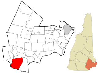
Chester is a town in Rockingham County, New Hampshire, United States. The population was 5,232 at the 2020 census, up from 4,768 at the 2010 census. It was home to the now defunct Chester College.

<span class="mw-page-title-main">Hampstead, New Hampshire</span> Place in New Hampshire, United States

Hampstead is a town in Rockingham County, New Hampshire, United States. The population was 8,998 at the 2020 census. Hampstead, which includes the village of East Hampstead, is home to a portion of the Rockingham Recreational Trail.

<span class="mw-page-title-main">Windham, New Hampshire</span> Town in New Hampshire, United States

Windham is a suburban town in Rockingham County, New Hampshire, United States. The population at the 2020 census was 15,817, up from 13,592 in 2010.

<span class="mw-page-title-main">Hooksett, New Hampshire</span> Town in New Hampshire, United States

Hooksett is a town in Merrimack County, New Hampshire, United States. The population was 14,871 at the 2020 census, up from 13,451 at the 2010 census. The town is located between Manchester, the state's largest city, and Concord, the state capital. A prominent landmark is Robie's Country Store, a National Historic Landmark and a frequent stop for presidential candidates during the New Hampshire primary.

<span class="mw-page-title-main">Derry (CDP), New Hampshire</span> Census-designated place in New Hampshire, United States

Derry is a census-designated place (CDP) in the town of Derry in Rockingham County, New Hampshire, United States. The CDP comprises the urban center of the town, as well as the village of East Derry and connected suburban areas. The population of the CDP was 22,879 at the 2020 census, out of 34,317 in the entire town.

<span class="mw-page-title-main">Londonderry (CDP), New Hampshire</span> Census-designated place in New Hampshire, United States

Londonderry is a census-designated place (CDP) within the town of Londonderry in Rockingham County, New Hampshire, United States. The population of the CDP was 11,645 at the 2020 census, out of 25,826 in the entire town.

<span class="mw-page-title-main">Londonderry, New Hampshire</span> Town in Rockingham County, New Hampshire, United States of America

Londonderry is a town in western Rockingham County, New Hampshire, United States. It sits between Manchester and Derry, the largest and fourth-largest communities in the state. The population was 25,826 at the 2020 census. Londonderry is known for its apple orchards and is home to the headquarters of Stonyfield Farm and part of Manchester–Boston Regional Airport.

<span class="mw-page-title-main">Derry, New Hampshire</span> Town in New Hampshire, United States

Derry is a town in Rockingham County, New Hampshire, United States. The population was 34,317 at the 2020 census. Although it is a town and not a city, Derry is the most populous community in Rockingham County and the 4th most populous in the state. The town's nickname, "Spacetown", derives from the fact that Derry is the birthplace of Alan Shepard, the first astronaut from the United States in space. Derry was also for a time the home of the poet Robert Frost and his family.

<span class="mw-page-title-main">Pinkerton Academy</span> Secondary school in Derry, New Hampshire, USA

Pinkerton Academy is a secondary school in Derry, New Hampshire, United States. It serves roughly 3,269 students, making it by far the largest high school in New Hampshire, more than 1,300 students greater than the next largest high school. Pinkerton's situation is unusual, as it is a privately-incorporated school that serves as the public high school for the communities of Derry, Hampstead, Chester, Auburn, Candia, and Hooksett. Through arrangements with the towns, each town pays the tuition for their students to attend Pinkerton. Pinkerton Academy is a private, non-profit corporation administered by a headmaster who acts under the direction of an elected board of trustees.

<span class="mw-page-title-main">Lake Massabesic</span>

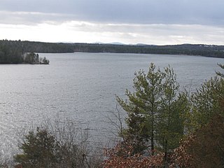
Lake Massabesic or Massabesic Lake is a lake in southern New Hampshire, United States, covering about 2,560 acres (1,040 ha) within the city of Manchester and the town of Auburn. Because it provides drinking water for Manchester, swimming and water skiing are not allowed there. Popular sports on the lake are sailing, fishing, and kayaking. The recreational trails along the lake provide views of the lake and the town of Auburn.

<span class="mw-page-title-main">Manchester Memorial High School</span> Public high school in Manchester, New Hampshire, United States

Manchester Memorial High School is a four-year comprehensive school in Manchester, New Hampshire, with an enrollment of approximately 1,600. It is a part of the Manchester School District. The school's Latin motto is "scientia est potentia."

Little Massabesic Brook and Sucker Brook form a 1.9-mile-long (3.1 km) stream located in southern New Hampshire in the United States. They are tributaries of Massabesic Lake, part of the Merrimack River and Gulf of Maine watersheds. Despite the streams' short length, they are subject to the New Hampshire Comprehensive Shoreland Protection Act, because of their fourth-order stream status.

Manchester School District is a school district headquartered in Manchester, New Hampshire.

References

  1. 1 2 "2021 U.S. Gazetteer Files – New Hampshire". United States Census Bureau. Retrieved December 17, 2021.
  2. 1 2 3 "Auburn town, Rockingham County, New Hampshire: 2020 DEC Redistricting Data (PL 94-171)". U.S. Census Bureau. Retrieved December 17, 2021.
  3. 1 2 3 Article in Statistics and Gazetteer of New-Hampshire (1875)
  4. Foster, Debra H.; Batorfalvy, Tatianna N.; Medalie, Laura (1995). Water Use in New Hampshire: An Activities Guide for Teachers. U.S. Department of the Interior and U.S. Geological Survey.
  5. 1 2 "NOAA Online Weather Data – NWS Gray". National Weather Service. Retrieved July 6, 2023.
  6. "U.S. Climate Normals Quick Access – Station: Massabesic Lake, NH". National Oceanic and Atmospheric Administration. Retrieved July 6, 2023.
  7. "Census of Population and Housing". Census.gov. Retrieved June 4, 2016.
  8. "U.S. Census website". United States Census Bureau . Retrieved January 31, 2008.
  9. "Boating on Lake Massabesic". City of Manchester. Retrieved March 21, 2011.
  10. "Massabesic Audubon Center, Auburn". New Hampshire Audubon. Retrieved December 17, 2021.
  11. "SAU 15 official website" . Retrieved November 10, 2015.
  12. "Sending towns". Pinkerton Academy . Retrieved April 24, 2022.
  13. Huss, Julie (March 17, 2011). "Pinkerton welcomes Auburn". Derry News . Retrieved April 25, 2022.
  14. "29NH - Cleary Airport | SkyVector". skyvector.com. Retrieved September 1, 2019.
  15. "Cleary New Hampshire Airport Information". FunPlacesToFly.com. Retrieved September 1, 2019.
  16. "Where are they now? Plymouth State Football Legend Joe Dudek