Westford, Massachusetts

Last updated

Westford, Massachusetts
Old Westford Academy, MA.jpg
Old Westford Academy,
now the Westford Museum
Seal of Westford, Massachusetts.png
Middlesex County Massachusetts incorporated and unincorporated areas Westford highlighted.svg
Location in Middlesex County in Massachusetts
Coordinates: 42°34′45″N71°26′18″W / 42.57917°N 71.43833°W / 42.57917; -71.43833
CountryUnited States
State Massachusetts
County Middlesex
Region New England
Settled1635 [1]
IncorporatedSeptember 23, 1729
Government
  Type Open town meeting
Area
  Total31.3 sq mi (81.1 km2)
  Land30.6 sq mi (79.3 km2)
  Water0.7 sq mi (1.9 km2)
Elevation
406 ft (124 m)
Population
 (2020)
  Total24,643
  Density712.1/sq mi (274.8/km2)
Time zone UTC−5 (Eastern)
  Summer (DST) UTC−4 (Eastern)
ZIP Code
01886
Area code 351/978
FIPS code 25-76135
GNIS feature ID0618244
Website www.westfordma.gov

Westford is a town in Middlesex County, Massachusetts, United States. The population was at 24,643 at the time of the 2020 Census. [2]

Contents

History

Westford Common, looking down Main Street Westford Common looking down Main St.jpg
Westford Common, looking down Main Street

Westford began as 'West Chelmsford', a village in the town of Chelmsford. The village of West Chelmsford grew large enough to sustain its own governance in 1729, and was officially incorporated as Westford that year on September 23. [3] [4]

In the late 18th and early 19th centuries, Westford primarily produced granite, apples, and worsted yarn. The Abbot Worsted Company was said to be the first company in the nation to use camel hair for worsted yarns. [5]

Henry Fletcher House was built c. 1813 WestfordMA HenryFletcherHouse.jpg
Henry Fletcher House was built c.1813

Paul Revere's son attended Westford Academy and a bell cast by Revere graces its lobby today. [6] A weather vane made by Paul Revere sits atop the Abbot Elementary school.

By the end of the American Civil War, as roads and transportation improved, Westford began to serve as a residential suburb for the factories of Lowell, becoming one of the earliest notable examples of suburban sprawl. Throughout the 20th century (and with the invention of the automobile), Westford progressively grew, continuing to serve as residential housing for the industries of Lowell, and later, Boston.

In the 1960s, the town was home to one of the research sites supporting Project West Ford.

By the 1970s, with the advent of the 128 Technology Belt, Westford began to act as a suburb for high-tech firms in Burlington, Woburn, and other areas, and later became a center of technology itself.

By the 1990s, Westford was home to offices for Cascade Communications (now part of Nokia), NETSCOUT, Red Hat, Samsung, Sonus Networks, Seagate, Iris Associates and many other technology firms, most located along Massachusetts Route 110, parallel to I-495. It is also the North American headquarters for Puma, which holds a road race in town. [7]

Geography

Lithograph of Westford from 1886 by L.R. Burleigh with list of landmarks Westford, Mass. (2673880403).jpg
Lithograph of Westford from 1886 by L.R. Burleigh with list of landmarks

According to the United States Census Bureau, the town has a total area of 31.3 square miles (81 km2), of which 30.6 square miles (79 km2) is land and 0.7 square miles (1.8 km2) (2.30%) is water.

Regionally, it is on the edge of the Merrimack Valley, Northern Middlesex County, and the Metrowest regions of Massachusetts.

Colloquially, the town is divided into different regions based on location, including Forge Village, Nabnasset, Graniteville, Parker Village, and Center of Town.

The town was rated as #11 Best Places to live by Money.com in 2013. [8]

Demographics

Historical population
YearPop.±%
1790 1,229 [9]     
1800 1,267 [10] +3.1%
1810 1,330 [11] +5.0%
1820 1,409 [12] +5.9%
1830 1,327 [13] −5.8%
1840 1,436 [14] +8.2%
1850 1,473+2.6%
1860 1,624+10.3%
1870 1,803+11.0%
1880 2,147+19.1%
1890 2,250+4.8%
1900 2,624+16.6%
1910 2,851+8.7%
1920 3,170+11.2%
1930 3,600+13.6%
1940 3,830+6.4%
1950 4,262+11.3%
1960 6,261+46.9%
1970 10,368+65.6%
1980 13,434+29.6%
1990 16,467+22.6%
2000 20,754+26.0%
2010 21,951+5.8%
2020 24,643+12.3%
2022*24,353−1.2%
* = population estimate.
Source: United States census records and Population Estimates Program data. [15] [16] [17] [18] [19] [20] [21] [22] [23] [24] [25]

As of the 2010 census [26] there were 21,951 people, 7,498 households, and 6,165 families residing in the town. The racial makeup of the town was 76.1% White, 0.40% African American, 0.1% Native American, 22.6% Asian (10.7% Indian, 8.2% Chinese, 1.6% Korean, 0.3% Cambodian, 0.2% Vietnamese, 0.2% Japanese, 0.1% Filipino, 0.1% Pakistani, 0.1% Bangladeshi), 0.0% Pacific Islander, 0.30% from other races, and 1.5% from two or more races. Hispanic or Latino of any race were 1.5% of the population.

As of the 2010 census, [26] there were 7,498 households, out of which 45.3% had children under the age of 18 living with them, 72.5% were married couples living together, 7.3% had a female head of household, and 17.8% were other families. The average household size was 2.93 and the average family size was 3.27.

In the town, the population was spread out, with 31.8% under the age of 18, 4.2% from 18 to 24, 32.8% from 25 to 44, 23.9% from 45 to 64, and 7.2% who were 65 years of age or older. The median age was 37 years. For every 100 females, there were 99.0 males. For every 100 females age 18 and over, there were 95.4 males.

The median income for a household in the town was $121,136, and the median income for a family was $137,230. The per capita income for the town was $48,951. About 1.3% of families and 1.7% of the population were below the poverty line, including 2.2% of those under age 18 and 1.0% of those age 65 or over.

Government

Voter Registration and Party Enrollment as of February 1, 2021 [27]
PartyNumber of VotersPercentage
Democratic 3,96221.75%
Republican 1,98710.91%
Unaffiliated12,09066.36%
Total18,220100%

Education

Westford Public Schools

The Superintendent of Westford's Public Schools is Christopher Chew, [28] who has held that role since 2021. The Assistant Superintendent is Courtney Moran. [29]

J.V. Fletcher Library, built 1895 1899 Westford public library Massachusetts.png
J.V. Fletcher Library, built 1895

Nashoba Valley Technical High School District

Nashoba Valley Technical High School enrolls students from Westford, Chelmsford, Ayer, Groton, Littleton, Townsend, Shirley, and Pepperell

Established in 1968, Nashoba Valley Technical High School is a public, four-year, vocational high school.

Transportation

Freight travels daily through Westford over the tracks of the historic Stony Brook Railroad. The line currently serves as a major corridor of Pan Am Railways' District 3 which connects New Hampshire and Maine with western Massachusetts, Vermont, and New York. [30] Interstate 495 also passes through the town, linking it to other parts of the state as well as New Hampshire. [31] US-3 passes through the town, although the nearest interchanges are located in neighboring Tyngsborough (exit 88, formerly 34) and Chelmsford (exit 86, formerly 33).

The LRTA 15 bus connects Westford along Route 110 with Chelmsford and the Lowell train station on the MBTA Commuter Rail Lowell Line.

Local routes passing through town are Massachusetts Routes 110, 40, 225, and 27.

Notable people

Points of interest

Related Research Articles

<span class="mw-page-title-main">Middlesex County, Massachusetts</span> County in Massachusetts, United States

Middlesex County is a county located in the Commonwealth of Massachusetts, United States. As of the 2020 census, the population was 1,632,002, making it the most populous county in both Massachusetts and New England and the 22nd most populous county in the United States. Middlesex County is one of two U.S. counties to be amongst the top 25 counties with the highest household income and the 25 most populated counties. It is included in the Census Bureau's Boston–Cambridge–Newton, MA–NH Metropolitan Statistical Area. As part of the 2020 United States census, the Commonwealth's mean center of population for that year was geo-centered in Middlesex County, in the town of Natick.

<span class="mw-page-title-main">Acton, Massachusetts</span> Town in Massachusetts, United States

Acton is a town in Middlesex County, Massachusetts, United States, approximately 21 miles (34 km) west-northwest of Boston along Massachusetts Route 2 west of Concord and about ten miles (16 km) southwest of Lowell. The population was 24,021 in April 2020, according to the United States Census Bureau. It is bordered by Westford and Littleton to the north, Concord and Carlisle to the east, Stow, Maynard, and Sudbury to the south and Boxborough to the west. Acton became an incorporated town in 1735. The town employs the Open Town Meeting form of government with a town manager and an elected, five-member select board. Acton was named the 11th Best Place To Live among small towns in the country by Money Magazine in 2015, and the 16th best in 2009 and in 2011. The local high school, Acton-Boxborough Regional High School, was named a Blue Ribbon School by the U.S. Department of Education in 2009.

<span class="mw-page-title-main">Billerica, Massachusetts</span> Town in Massachusetts, United States

Billerica is a town in Middlesex County, Massachusetts, United States. The population was 42,119 according to the 2020 census. It takes its name from the town of Billericay in Essex, England.

<span class="mw-page-title-main">Carlisle, Massachusetts</span> Town in Massachusetts, United States

Carlisle is a town located northwest of Boston in Middlesex County, Massachusetts, United States. As of the 2020 U.S. Census, the town had a population of 5,237.

<span class="mw-page-title-main">Chelmsford, Massachusetts</span> Town in Massachusetts, United States

Chelmsford is a town in Middlesex County, Massachusetts, United States. It was established in 1655. The Chelmsford militia played a role in the American Revolution at the Battle of Lexington and Concord and the Battle of Bunker Hill.

<span class="mw-page-title-main">Dracut, Massachusetts</span> Town in Massachusetts, United States

Dracut is a town in Middlesex County, Massachusetts, United States. At the 2020 census, the town's population was 32,617, making it the second most populous town in Massachusetts with an open town meeting system of governance. The town covers a total area of 21.36 square miles, 0.5 square miles of which are water.

<span class="mw-page-title-main">Dunstable, Massachusetts</span> Town in Massachusetts, United States

Dunstable is a town in Middlesex County, Massachusetts, United States. The population was 3,358 at the 2020 census.

<span class="mw-page-title-main">Littleton, Massachusetts</span> Town in Massachusetts, United States

Littleton is a town in Middlesex County, Massachusetts, United States. The population was 10,141 at the 2020 census.

<span class="mw-page-title-main">Littleton Common, Massachusetts</span> Census-designated place in Massachusetts, United States

Littleton Common is a census-designated place (CDP) in the town of Littleton in Middlesex County, Massachusetts, United States. The population was 3,065 at the 2020 census, up from 2,789 in 2010.

<span class="mw-page-title-main">Tewksbury, Massachusetts</span> Town in Massachusetts, United States

Tewksbury is a town in Middlesex County, Massachusetts, United States. Its population was 26,342 as of the 2020 United States Census.

<span class="mw-page-title-main">Tyngsborough, Massachusetts</span> Town in Massachusetts, United States

Tyngsborough is a town in northern Middlesex County, Massachusetts, United States. Tyngsborough is 28 miles (45 km) from Boston along the Route 3 corridor, and located on the New Hampshire state line. At the 2020 census, the town population was 12,380. By its location, the town serves as a suburb of neighboring cities such as Nashua, New Hampshire and Lowell, Massachusetts.

<span class="mw-page-title-main">Woburn, Massachusetts</span> City in Massachusetts, United States

Woburn is a city in Middlesex County, Massachusetts, United States. The population was 40,876 at the 2020 census. Woburn is located 9 miles (14 km) north of Boston. Woburn uses Massachusetts' mayor-council form of government, in which an elected mayor is the executive and a partly district-based, partly at-large city council is the legislature. It was the last of Massachusetts' 351 municipalities to refer to members of its city council as "aldermen".

<span class="mw-page-title-main">Wilmington, Massachusetts</span> Town in Massachusetts, United States

Wilmington is a town in Middlesex County, Massachusetts, United States. Its population was 23,349 at the 2020 United States census.

<span class="mw-page-title-main">Groton, Massachusetts</span> Town in Massachusetts, United States

Groton is a town in northwestern Middlesex County, Massachusetts, United States, within the Greater Boston metropolitan area. The population was 11,315 at the 2020 census. An affluent bedroom community roughly 45 miles from Boston, Groton has a large population of professional workers, many of whom work in Boston's tech industry. It is loosely connected to Boston by highways and commuter rail.

<span class="mw-page-title-main">Greater Lowell</span> Region of Massachusetts in the United States

Greater Lowell is the region comprising the city of Lowell, Massachusetts, and its suburbs. These lie in northern Middlesex County, Massachusetts; in the Merrimack Valley; and in southern New Hampshire.

<span class="mw-page-title-main">Nashoba Valley Technical High School</span> Public regional vocational technical school in Westford, Massachusetts, USA

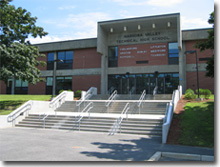
Nashoba Valley Technical High School is a four-year, public regional vocational high school located on Route 110 in Westford, Massachusetts, United States. Following a $25 million renovation and expansion, its service area covers 14 communities including the seven District towns of Ayer, Chelmsford, Groton, Littleton, Pepperell, Shirley, Townsend and Westford.

<span class="mw-page-title-main">Ayer, Massachusetts</span> Town in Massachusetts, United States

Ayer is a town in Middlesex County, Massachusetts, United States. Originally part of Groton, it was incorporated February 14, 1871, and became a major commercial railroad junction. The town was home to Camp Stevens, a training camp for Massachusetts volunteers during the American Civil War. Later, Fort Devens was established by the federal government to train New England soldiers for World War I. Fort Devens is a major influence on the area, although it is considerably smaller than when it was first closed in the mid-1990s. The town's population was 8,479 at the 2020 census.

<span class="mw-page-title-main">Shirley, Massachusetts</span> Town in Massachusetts, United States

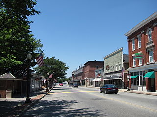
Shirley is a town in Middlesex County, Massachusetts, United States. It is approximately thirty miles west-northwest of Boston. The population was 7,431 at the 2020 census. The town has a well-preserved historic New England town center.

<span class="mw-page-title-main">Townsend, Massachusetts</span> Town in Massachusetts, United States

Townsend is a town in Middlesex County, Massachusetts, United States. The population was 9,127 at the 2020 census.

Edward Edwin Fitzgibbon was a farmer, teacher, and politician.

References

  1. History of the town of Westford, in the county of Middlesex, Massachusetts, 1659–1883 by Hodgman, Edwin R. (Edwin Ruthven), 1819–1900; Westford Town History Association (Westford, Mass.)
  2. "Census - Geography Profile: Westford town, Middlesex County, Massachusetts". November 7, 2021.
  3. "HTML Error 404 – Page Not Found – Westford, Massachusetts".{{cite web}}: Cite uses generic title (help)
  4. "How Did Westford Split From Chelmsford?". Westford, MA Patch. November 16, 2011.
  5. Oliphant, Robert W. "A brief history of Westford". Westford Museum and Historical Society. Retrieved April 18, 2014.
  6. "History of Westford Academy - Westford, MA - Westford Eagle". Archived from the original on May 20, 2011. Retrieved September 20, 2011.
  7. IMAGE GALLERY: Puma 5 Miler Road Race, Westford Patch
  8. "Best Places To Live 2013". Money.com. 2013. Retrieved April 2, 2018.
  9. ""United States Census, 1790," database with images, FamilySearch, Massachusetts > Middlesex > Westford > image 2 of 2; citing NARA microfilm publication M637, (Washington D.C.: National Archives and Records Administration, n.d.), archive date 14 May 2015". FamilySearch.org. Retrieved May 28, 2022.
  10. ""United States Census, 1800," database with images, FamilySearch, Massachusetts > Middlesex > Westford > image 6 of 6; citing NARA microfilm publication M32, (Washington D.C.: National Archives and Records Administration, n.d.), archive date 10 June 2015". FamilySearch.org. Retrieved May 28, 2022.
  11. ""United States Census, 1810," database with images, FamilySearch, Massachusetts > Middlesex > Groton > image 18 of 27; citing NARA microfilm publication M252, (Washington D.C.: National Archives and Records Administration, n.d.), archive date 1 December 2015". FamilySearch.org. Retrieved May 28, 2022.
  12. ""United States Census, 1820," database with images, FamilySearch, Massachusetts > Middlesex > Westford > image 6 of 6; citing NARA microfilm publication M33, (Washington D.C.: National Archives and Records Administration, n.d.), archive date 16 July 2015". FamilySearch.org. Retrieved May 28, 2022.
  13. ""United States Census, 1830," database with images, FamilySearch, Massachusetts > Middlesex > Westford > image 20 of 20; citing NARA microfilm publication M19, (Washington D.C.: National Archives and Records Administration, n.d.), archive date 5 August 2015". FamilySearch.org. Retrieved May 28, 2022.
  14. ""United States Census, 1840," database with images, FamilySearch Massachusetts > Middlesex > Westford > image 18 of 18; citing NARA microfilm publication M704, (Washington D.C.: National Archives and Records Administration, n.d.), access date 24 August 2015". FamilySearch.org. Retrieved May 28, 2022.
  15. "Total Population (P1), 2010 Census Summary File 1". American FactFinder, All County Subdivisions within Massachusetts. United States Census Bureau. 2010.
  16. "Massachusetts by Place and County Subdivision - GCT-T1. Population Estimates". United States Census Bureau. Retrieved July 12, 2011.
  17. "1990 Census of Population, General Population Characteristics: Massachusetts" (PDF). US Census Bureau. December 1990. Table 76: General Characteristics of Persons, Households, and Families: 1990. 1990 CP-1-23. Retrieved July 12, 2011.
  18. "1980 Census of the Population, Number of Inhabitants: Massachusetts" (PDF). US Census Bureau. December 1981. Table 4. Populations of County Subdivisions: 1960 to 1980. PC80-1-A23. Retrieved July 12, 2011.
  19. "1950 Census of Population" (PDF). Bureau of the Census. 1952. Section 6, Pages 21-10 and 21-11, Massachusetts Table 6. Population of Counties by Minor Civil Divisions: 1930 to 1950. Retrieved July 12, 2011.
  20. "1920 Census of Population" (PDF). Bureau of the Census. Number of Inhabitants, by Counties and Minor Civil Divisions. Pages 21-5 through 21-7. Massachusetts Table 2. Population of Counties by Minor Civil Divisions: 1920, 1910, and 1920. Retrieved July 12, 2011.
  21. "1890 Census of the Population" (PDF). Department of the Interior, Census Office. Pages 179 through 182. Massachusetts Table 5. Population of States and Territories by Minor Civil Divisions: 1880 and 1890. Retrieved July 12, 2011.
  22. "1870 Census of the Population" (PDF). Department of the Interior, Census Office. 1872. Pages 217 through 220. Table IX. Population of Minor Civil Divisions, &c. Massachusetts. Retrieved July 12, 2011.
  23. "1860 Census" (PDF). Department of the Interior, Census Office. 1864. Pages 220 through 226. State of Massachusetts Table No. 3. Populations of Cities, Towns, &c. Retrieved July 12, 2011.
  24. "1850 Census" (PDF). Department of the Interior, Census Office. 1854. Pages 338 through 393. Populations of Cities, Towns, &c. Retrieved July 12, 2011.
  25. "City and Town Population Totals: 2020−2022". United States Census Bureau . Retrieved November 24, 2023.
  26. 1 2 "U.S. Census website". United States Census Bureau . Retrieved January 31, 2008.
  27. "Registration and Party Enrollment Statistics as of February 1, 2021" (PDF). Massachusetts Elections Division. Archived (PDF) from the original on April 22, 2021. Retrieved May 30, 2021.
  28. "Lifting the curtain on Westford's new superintendent, Christopher Chew". March 28, 2021.
  29. "Courtney Moran appointed as new assistant superintendent for WPS". WestfordCAT. June 3, 2023. Retrieved April 3, 2024.
  30. Pan Am Railways route map Archived January 11, 2007, at the Wayback Machine .panamrailways.com. Accessed April 30, 2007.
  31. "interstate-guide.com". Accessed November 5, 2008.
  32. Who Was Who in America, Historical Volume, 1607-1896. Marquis Who's Who. 1967.
  33. "World Golf Hall of Fame Profile: Pat Bradley".
  34. Hare, Bill (November 3, 2010), Mike Fucito: Seattle Sounders' Embodiment of Desire and Spirit, Bleacher Report , retrieved January 22, 2012
  35. "Ellen Swallow Richards", Biographical Snapshots of Famous Women and Minority Chemists, Journal of Chemical Education, retrieved January 22, 2012
  36. Massachusetts Soldiers and Sailors of the Revolutionary War, 1775-1783, vol. 13, Boston: Wright and Potter, 1905, p. 451
  37. O'Connor, Austin (May 4, 2003), "Westford actor Aaron Stanford is hot", Lowell Sun , retrieved January 22, 2012
  38. "Westford, MA". Kimball Farm. Retrieved January 29, 2024.

Further reading