
Middlesex County is a county located in the Commonwealth of Massachusetts, United States. As of the 2020 census, the population was 1,632,002, making it the most populous county in both Massachusetts and New England and the 22nd most populous county in the United States. Middlesex County is one of two U.S. counties to be amongst the top 25 counties with the highest household income and the 25 most populated counties. It is included in the Census Bureau's Boston–Cambridge–Newton, MA–NH Metropolitan Statistical Area. As part of the 2020 United States census, the Commonwealth's mean center of population for that year was geo-centered in Middlesex County, in the town of Natick.

Billerica is a town in Middlesex County, Massachusetts, United States. The population was 42,119 according to the 2020 census. It takes its name from the town of Billericay in Essex, England.

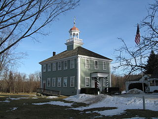
Chelmsford is a town in Middlesex County, Massachusetts, United States. It was established in 1655. The Chelmsford militia played a role in the American Revolution at the Battle of Lexington and Concord and the Battle of Bunker Hill.
Westford is a town in Middlesex County, Massachusetts, United States. The population was at 24,643 at the time of the 2020 Census.
Pelham is a town in Hillsborough County, New Hampshire, United States. The population was 14,222 at the 2020 census, up from 12,897 at the 2010 census.

Wilmington is a town in Middlesex County, Massachusetts, United States. Its population was 23,349 at the 2020 United States census.

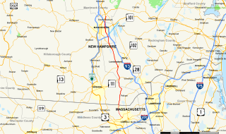
U.S. Route 3 (US 3) is a United States Numbered Highway running 277.90 miles (447.24 km) from Cambridge, Massachusetts, through New Hampshire, to the Canada–United States border near Third Connecticut Lake, where it connects to Quebec Route 257.

Interstate 495 (I-495) is an auxiliary route of I-95 in the US state of Massachusetts, maintained by the Massachusetts Department of Transportation (MassDOT). Spanning 121.56 miles (195.63 km), it is the second-longest auxiliary route in the Interstate Highway System, being roughly 11 miles (18 km) shorter than I-476 in Pennsylvania.

Route 2 is a 142.29-mile-long (228.99 km) major east–west state highway in Massachusetts, United States. Along with Route 9 and U.S. Route 20 to the south, these highways are the main alternatives to the Massachusetts Turnpike/I-90 toll highway. Route 2 runs the entire length of the northern tier of Massachusetts, beginning at the New York border, where it connects with New York State Route 2, and ending near Boston Common in Boston. Older alignments of Route 2 are known as Route 2A.

Route 4 is an 18.26-mile-long (29.39 km) state highway in northeastern Massachusetts. It runs south to north, serving many of Boston's western and northwestern suburbs, from an interchange with Route 2 in Lexington northwest to an intersection with Route 3A in North Chelmsford. Much of it, north of Lexington, runs parallel to U.S. Route 3. The entire route is contained within Middlesex County.
Mammoth Road is a north–south road in Massachusetts and New Hampshire. The road runs from its origin in Lowell, Massachusetts to its northern end in Hooksett, New Hampshire, a suburb of Manchester. The total length of the road is 29.3 miles (47.2 km). It was named "Mammoth" in the hope that the convenience of its directness and elimination of smaller connecting roads between thoroughfares would result in sufficient use and prestige as to "kill all the other roads".

Route 27 is a 73.44-mile-long (118.19 km) south–north state highway in eastern Massachusetts. Its southern terminus is at Route 106 in Kingston and its northern terminus is at Route 4 in Chelmsford. Along the way it intersects several major highways including Route 24 in Brockton, U.S. Route 1 in Walpole, Route 9 in Natick, US 20 in Wayland, and Route 2 in Acton.

Route 40 is a 10.46-mile-long (16.83 km) east–west state route located in northeastern Massachusetts, entirely within Middlesex County. The short highway connects Groton and Chelmsford. Its western end is at an intersection with Massachusetts Route 119 and Massachusetts Route 225 in Groton, and its eastern end is at Route 3A in North Chelmsford. The route has existed since the late 1940s.

North Billerica is an unincorporated village of the town of Billerica, Massachusetts, United States, one of the nine sections (hamlets) that make up the Town of Billerica. It is the home to Faulkner and Talbot mills and the North Billerica Train Depot. The Middlesex Canal was built through the village in 1783 and the Boston and Lowell Railroad was put through in the 1840s.

The Middlesex Turnpike was an early turnpike between Cambridge and Tyngsborough, Massachusetts and the New Hampshire border, where it connected with the Amherst Turnpike and thence Nashua and Claremont, New Hampshire.

The Bay Circuit Trail and Greenway or Bay Circuit is a Massachusetts rail trail and greenway connecting the outlying suburbs of Boston from Plum Island in Newburyport to Kingston Bay in Duxbury, a distance of 200 miles (320 km).
The Massachusetts Department of Youth Services (DYS) is a state agency of Massachusetts. Its administrative office is headquartered in 600 Washington Street, Boston. The agency operates the state's juvenile justice services and facilities for incarcerated of children.

This is a list of roundabouts in the state of Massachusetts in the United States. Intersections that are called traffic circles or roundabouts in the rest of the US are referred to as "rotaries" in Massachusetts, as well as other parts of New England including parts of Connecticut, New Hampshire, Maine Rhode Island, & Vermont.

Westborough is a town in Worcester County, Massachusetts, United States. The population was 21,567 at the 2020 Census, in over 7,000 households. Incorporated in 1717, the town is governed under the New England open town meeting system, headed by a five-member elected Board of Selectmen whose duties include licensing, appointing various administrative positions, and calling a town meeting of citizens annually or whenever the need arises.

The Middlesex County Training School is a former reform school located in North Chelmsford, Massachusetts. After its closure, its buildings were purchased by the University of Massachusetts Lowell, which utilized its buildings for its College of Education. Today, the school's records are housed in the Massachusetts Archives.


