Hudson (CDP), Massachusetts

Last updated

Hudson, Massachusetts
Hudson Town Hall.jpg
Hudson Town Hall
Middlesex County Massachusetts incorporated and unincorporated areas Hudson (CDP) highlighted.svg
Location in Middlesex County in Massachusetts
Coordinates: 42°23′32″N71°33′56″W / 42.39222°N 71.56556°W / 42.39222; -71.56556
Country United States
State Massachusetts
County Middlesex
Town Hudson
Area
[1]
  Total5.92 sq mi (15.33 km2)
  Land5.75 sq mi (14.88 km2)
  Water0.17 sq mi (0.45 km2)
Elevation
217 ft (66 m)
Population
 (2020) [2]
  Total15,749
  Density2,741.34/sq mi (1,058.42/km2)
Time zone UTC-5 (Eastern (EST))
  Summer (DST) UTC-4 (EDT)
ZIP code
01749
Area code 978
FIPS code 25-31575
GNIS feature ID0611243

Hudson is a census-designated place (CDP) comprising the densely developed central part of the town of Hudson in Middlesex County, Massachusetts, United States. The population of the CDP was 15,749 at the 2020 census, [2] out of 20,092 in the entire town.

Contents

Geography

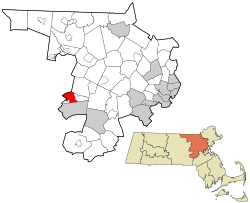
The CDP is located on the western edge of Middlesex County at 42°23′32″N71°33′56″W / 42.39222°N 71.56556°W / 42.39222; -71.56556 (42.392285, -71.565646), [3] in the west-central part of the town of Hudson. It is bordered to the south by the city of Marlborough, to the northeast by the town of Stow, and to the northwest and west by the towns of Bolton and Berlin in Worcester County. Within the town of Hudson, the CDP is bordered to the east by Zina Road, Cox Street, Forest Avenue, Old North Road, and Causeway Street, and to the southwest by Chapin Road, Brigham Street, Washington Street, and the Assabet River Rail Trail. [4]

Massachusetts Route 62 passes through the community as Central Street and Main Street, leading northeast 5 miles (8 km) to the center of Stow and west 4 miles (6 km) to the center of Berlin. Massachusetts Route 85 runs through the community as Washington Street and Lincoln Street, leading north 3 miles (5 km) to Route 117 in Bolton and southwest 3.5 miles (5.6 km) to the center of Marlborough. Route 85C turns southwest from Route 85 in the southern part of the CDP and leads 1.5 miles (2.4 km) to the I-495/I-290 interchange.

According to the United States Census Bureau, the CDP has a total area of 5.92 square miles (15.33 km2), of which 5.75 square miles (14.89 km2) are land and 0.18 square miles (0.47 km2), or 2.96%, are water. [1] The Assabet River passes through the center of the CDP, flowing northeastward to join the Concord River in Concord. Via the Concord River, the CDP is part of the Merrimack River watershed.

Demographics

Historical population
CensusPop.Note
1960 7,897
1970 14,28380.9%
1980 14,156−0.9%
1990 14,2670.8%
2000 14,3880.8%
2010 14,9073.6%
2020 15,7495.6%
U.S. Decennial Census [5]

As of the census [6] of 2000, there were 14,388 people, 5,652 households, and 3,809 families residing in the CDP. The population density was 971.2/km2 (2,517.1/mi2). There were 5,790 housing units at an average density of 390.8/km2 (1,012.9/mi2). The racial makeup of the CDP was 93.91% White, 0.88% Black or African American, 0.15% Native American, 1.22% Asian, 0.03% Pacific Islander, 1.64% from other races, and 2.18% from two or more races. Hispanic or Latino of any race were 3.48% of the population.

There were 5,652 households, out of which 30.4% had children under the age of 18 living with them, 54.2% were married couples living together, 9.7% had a female householder with no husband present, and 32.6% were non-families. 27.1% of all households were made up of individuals, and 10.6% had someone living alone who was 65 years of age or older. The average household size was 2.52 and the average family size was 3.10.

In the CDP, the population was spread out, with 23.2% under the age of 18, 7.0% from 18 to 24, 33.5% from 25 to 44, 23.2% from 45 to 64, and 13.1% who were 65 years of age or older. The median age was 37 years. For every 100 females, there were 96.2 males. For every 100 females age 18 and over, there were 93.9 males.

The median income for a household in the CDP was $55,063, and the median income for a family was $67,643. Males had a median income of $43,815 versus $35,068 for females. The per capita income for the CDP was $25,167. About 3.3% of families and 5.3% of the population were below the poverty line, including 4.0% of those under age 18 and 10.5% of those age 65 or over.

Related Research Articles

<span class="mw-page-title-main">East Harwich, Massachusetts</span> Census-designated place in Massachusetts, United States

East Harwich is a census-designated place (CDP) and village in the town of Harwich in Barnstable County, Massachusetts, United States. The population was 4,872 at the 2010 census.

<span class="mw-page-title-main">East Sandwich, Massachusetts</span> Census-designated place in Massachusetts, United States

East Sandwich is a village and census-designated place (CDP) within the town of Sandwich in Barnstable County, Massachusetts, United States. The population was 3,940 at the 2010 census.

<span class="mw-page-title-main">Monson Center, Massachusetts</span> Census-designated place in Massachusetts, United States

Monson Center is a census-designated place (CDP) in the town of Monson in Hampden County, Massachusetts, United States. The population was 2,107 at the 2010 census, out of a total 8,560 people in the town. It is part of the Springfield, Massachusetts Metropolitan Statistical Area.

<span class="mw-page-title-main">Cochituate, Massachusetts</span> Census-designated place in Massachusetts, United States

Cochituate is a census-designated place (CDP) in the town of Wayland in Middlesex County, Massachusetts, United States. The population was 6,927 at the 2020 census, out of 13,943 in the entire town of Wayland.

<span class="mw-page-title-main">East Pepperell, Massachusetts</span> Census-designated place in Massachusetts, United States

East Pepperell is a village and census-designated place (CDP) in the town of Pepperell in Middlesex County, Massachusetts, United States. The population was 2,120 at the 2020 census.

<span class="mw-page-title-main">Littleton Common, Massachusetts</span> Census-designated place in Massachusetts, United States

Littleton Common is a census-designated place (CDP) in the town of Littleton in Middlesex County, Massachusetts, United States. The population was 3,065 at the 2020 census, up from 2,789 in 2010.

<span class="mw-page-title-main">West Concord, Massachusetts</span> Census-designated place in Massachusetts, United States

West Concord is an unincorporated village and census-designated place (CDP) in the town of Concord in Middlesex County, Massachusetts, United States. The population was 6,320 at the 2020 census.

<span class="mw-page-title-main">Upton (CDP), Massachusetts</span> Census-designated place in Massachusetts, United States

Upton is a census-designated place (CDP) in the town of Upton in Worcester County, Massachusetts, United States. The population was 3,013 at the 2010 census, out of 7,542 in the entire town. The CDP includes the villages of Upton and West Upton.

<span class="mw-page-title-main">Great Barrington (CDP), Massachusetts</span> Census-designated place in Massachusetts, United States

Great Barrington is a census-designated place (CDP) located in the town of Great Barrington in Berkshire County, Massachusetts, United States. The population was 2,231 at the 2010 census, out of 7,104 in the entire town of Great Barrington.

<span class="mw-page-title-main">Lenox (CDP), Massachusetts</span> Census-designated place in Massachusetts, United States

Lenox, also known as Lenox Center, is a census-designated place (CDP) in the town of Lenox in Berkshire County, Massachusetts, United States. The population was 1,675 at the 2010 census, out of 5,025 in the entire town of Lenox.

<span class="mw-page-title-main">Williamstown (CDP), Massachusetts</span> Census-designated place in Massachusetts, United States

Williamstown is a census-designated place (CDP) in the town of Williamstown in Berkshire County, Massachusetts, United States. The population of the CDP was 4,325 at the 2010 census, out of 7,754 in the entire town.

<span class="mw-page-title-main">Wilbraham (CDP), Massachusetts</span> Census-designated place in Massachusetts, United States

Wilbraham is a census-designated place (CDP) in the town of Wilbraham in Hampden County, Massachusetts, United States. The population was 3,915 at the 2010 census, out of 14,868 in the town as a whole. It is part of the Springfield, Massachusetts Metropolitan Statistical Area.

<span class="mw-page-title-main">Belchertown (CDP), Massachusetts</span> Census-designated place in Massachusetts, United States

Belchertown is a census-designated place (CDP) comprising the central village in the town of Belchertown in Hampshire County, Massachusetts, United States. The population was 2,899 at the 2010 census, out of a total town population of 14,649. It is part of the Springfield, Massachusetts Metropolitan Statistical Area.

<span class="mw-page-title-main">Granby (CDP), Massachusetts</span> Census-designated place in Massachusetts, United States

Granby is a census-designated place (CDP) comprising the main village in the town of Granby in Hampshire County, Massachusetts, United States. The population of the CDP was 1,368 at the 2010 census, out of a total town population of 6,240. It is part of the Springfield, Massachusetts Metropolitan Statistical Area.

<span class="mw-page-title-main">Ware (CDP), Massachusetts</span> Census-designated place in Massachusetts, United States

Ware is a census-designated place (CDP) comprising the main village in the town of Ware in Hampshire County, Massachusetts, United States. The population of the CDP was 6,170 at the 2010 census, out of a total town population of 9,872. It is part of the Springfield, Massachusetts Metropolitan Statistical Area.

<span class="mw-page-title-main">Ayer (CDP), Massachusetts</span> Census-designated place in Massachusetts, United States

Ayer is a census-designated place (CDP) and the primary settlement in the town of Ayer in Middlesex County, Massachusetts, United States. The population of the CDP was 2,986 at the 2020 census, out of 8,479 in the entire town.

<span class="mw-page-title-main">Groton (CDP), Massachusetts</span> Census-designated place in Massachusetts, United States

Groton is a census-designated place (CDP) comprising the main village in the town of Groton in Middlesex County, Massachusetts, United States. The population of the CDP was 1,353 at the 2020 census, out of 11,315 in the entire town of Groton.

<span class="mw-page-title-main">Pepperell (CDP), Massachusetts</span> Census-designated place in Massachusetts, United States

Pepperell is a census-designated place (CDP) comprising the main village in the town of Pepperell in Middlesex County, Massachusetts, United States. The population was 2,390 at the 2020 census, out of 11,604 in the entire town of Pepperell.

<span class="mw-page-title-main">Shirley (CDP), Massachusetts</span> Census-designated place in Massachusetts, United States

Shirley is a census-designated place (CDP) comprising the main village in the town of Shirley in Middlesex County, Massachusetts, United States. The population was 1,611 at the 2020 census, out of 7,431 in the entire town of Shirley.

<span class="mw-page-title-main">Townsend (CDP), Massachusetts</span> Census-designated place in Massachusetts, United States

Townsend is a census-designated place (CDP) comprising the main village in the town of Townsend in Middlesex County, Massachusetts, United States. The population was 1,213 at the 2020 census, out of 9,127 in the entire town.

References

  1. 1 2 "2022 U.S. Gazetteer Files: Massachusetts". United States Census Bureau. Retrieved June 12, 2023.
  2. 1 2 "P1. Race – Hudson CDP, Massachusetts: 2020 DEC Redistricting Data (PL 94-171)". U.S. Census Bureau. Retrieved June 12, 2023.
  3. "US Gazetteer files: 2010, 2000, and 1990". United States Census Bureau. February 12, 2011. Retrieved April 23, 2011.
  4. "TIGERweb: Hudson CDP, Massachusetts". Geography Division, U.S. Census Bureau. Retrieved June 12, 2023.
  5. "Census of Population and Housing". Census.gov. Retrieved June 4, 2016.
  6. "U.S. Census website". United States Census Bureau . Retrieved January 31, 2008.