
Acton is a town in Middlesex County, Massachusetts, United States, approximately 21 miles (34 km) west-northwest of Boston along Route 2 west of Concord and about ten miles (16 km) southwest of Lowell. The population was estimated to be 23,662 in July 2019, according to the United States Census Bureau. It is bordered by Westford and Littleton to the north, Concord and Carlisle to the east, Stow, Maynard, and Sudbury to the south and Boxborough to the west. Acton became an incorporated town in 1735. The town employs the Open Town Meeting form of government with a town manager and an elected, five-member board of selectmen. Acton was named the 11th Best Place To Live among small towns in the country by Money Magazine in 2015, and the 16th best in 2009 and in 2011. The local high school, Acton-Boxborough Regional High School, was named a Blue Ribbon School by the U.S. Department of Education in 2009.

Stow is a town in Middlesex County, Massachusetts, United States. The town is located 21 miles west of Boston, in the MetroWest region of Massachusetts. The population was 7,234 in 2019. Stow was officially incorporated in 1683 with an area of approximately 40 square miles. Over centuries it gave up land as newer, smaller towns were created, ceding land to Harvard (1732), Shirley (1765), Boxborough (1783), Hudson (1866) and Maynard (1871). Stow now has an area of 18.1 square miles (47 km2). With the exception of factories at Assabet Village and Rock Bottom, Stow was primarily sparsely settled farm and orchard land until the 1950s.

Sudbury is a town in Middlesex County, Massachusetts, United States. At the 2010 census, it had a population of 17,659. The town, located in Boston's MetroWest, has a rich colonial history.

Sutton is a town in Worcester County, Massachusetts, United States. The population was 8,963 at the 2010 census.

Maynard is a small suburban town in Middlesex County, Massachusetts, United States. The town is located 22 miles west of Boston, in the MetroWest and Greater Boston region of Massachusetts and borders Acton, Concord, Stow and Sudbury. From the Census Bureau 2019 American Community Survey, the town population was estimated at 10,754. This was an increase from the 2010 census count of 10,106.
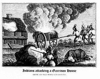
King Philip's War was an armed conflict in 1675–1678 between indigenous inhabitants of New England and New England colonists and their indigenous allies. The war is named for Metacom, the Wampanoag chief who adopted the name Philip because of the friendly relations between his father Massasoit and the Mayflower Pilgrims. The war continued in the most northern reaches of New England until the signing of the Treaty of Casco Bay in April 1678.

The Central Massachusetts Railroad was a railroad in Massachusetts. The eastern terminus of the line was at North Cambridge Junction where it split off from the Middlesex Central Branch of the Boston and Lowell Railroad in North Cambridge and through which it had access to North Station in Boston. From there, the route ran 98.77 miles west through the modern-day towns of Belmont, Waltham, Weston, Wayland, Sudbury, Hudson, Bolton, Berlin, Clinton, West Boylston, Holden, Rutland, Oakham, Barre, New Braintree, Hardwick, Ware, Palmer, Belchertown, Amherst, and Hadley to its western terminal junction at N. O. Tower in Northampton with the Connecticut River Railroad.

The Assabet River is a small, 34.4-mile (55.4 km) long river located about 20 miles (30 km) west of Boston, Massachusetts, United States. The Assabet rises from a swampy area known as the Assabet Reservoir in Westborough, Massachusetts, and flows northeast before merging with the Sudbury River at Egg Rock in Concord, Massachusetts, to become the Concord River. The Organization for the Assabet, Sudbury and Concord Rivers (OARS), headquartered in West Concord, Massachusetts, is a non-profit organization dedicated to the preservation, protection, and enhancement of the natural and recreational features of these three rivers and their watershed. As the Concord River is a tributary of the Merrimack River, it and the Assabet and Sudbury rivers are part of the larger Merrimack River watershed.
The Nipmuc or Nipmuck people are descendants of the indigenous Algonquian peoples of Nippenet, 'the freshwater pond place', which corresponds to central Massachusetts and immediately adjacent portions of Connecticut and Rhode Island. The English had their first encounter with members of the tribe in 1630, when John Acquittamaug (Nipmuc) took maize to sell to the starving colonists of Boston.

South Acton is an MBTA Commuter Rail station in Acton, Massachusetts. It serves the Fitchburg Line. It is located off Route 27 near Route 2 in the South Acton area. It is the busiest station on the Fitchburg line, averaging 991 weekday boardings. It serves as a park and ride station for Acton and other suburbs of Boston, with a 287-space parking lot owned by the town.
Acton, Massachusetts is a small town west of Boston in an area that has records of human habitation which stretch back 7000 years. Acton citizens had a significant role in the Battle of Lexington and Concord, the prelude to the American Revolution. Acton's history reflects the major events that were occurring in Massachusetts, New England, the United States, and the world.

Lake Boon is a lake in eastern Massachusetts covering about 163 acres (0.66 km2) in the towns of Stow and Hudson, Massachusetts. The lake is approximately 1.5 miles long and consists of four basins connected by narrows. The first and largest basin at the north-west end of the lake stretches from a dam along Barton Road in Stow down to narrows just above the towns south border. It is the only part of the lake that is completely within Stow. The second basin is about half the size of the first and straddles the border with Hudson. The 3rd and 4th basins at the eastern end of the lake are much smaller and less easily navigable due to shallow waters and significant plant-growth.
Beacon Communications Corp. was a newspaper publisher in Acton, Massachusetts, United States, operating a dozen weekly newspapers as well as daily newspapers in Hudson and Marlborough, Massachusetts. It was bought by Fidelity Investments in 1993 and incorporated into Community Newspaper Company, Massachusetts' largest weekly newspaper publisher, now owned by GateHouse Media.

The Old Connecticut Path was the Native American trail that led westward from the area of Massachusetts Bay to the Connecticut River Valley, the first of the North American trails that led west from the settlements close to the Atlantic seacoast, towards the interior. The earliest colonists of Massachusetts Bay Colony used it, and rendered it wider by driving cattle along it. The old route is still followed, for part of its length, by Massachusetts Route 9 and Massachusetts Route 126.
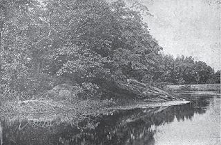
Egg Rock is an outcrop of Silurian Straw Hollow Diorite at the confluence of the Assabet and Sudbury rivers, where they form the Concord River in Concord, Massachusetts. The outcrop is located on a roughly oval intermittent island of about 100 by 50 meters. Egg Rock is usually accessible using foot trails over land, but during high river levels the island is separated from the mainland by a narrow channel. The highest point of Egg Rock is about 39 meters above mean sea level and about 6 meters above normal river level.
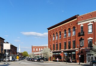
Hudson is a town in Middlesex County, Massachusetts, United States, with a total population of 19,063 as of the 2010 census. Before its incorporation as a town in 1866, Hudson was a neighborhood and unincorporated village of Marlborough, Massachusetts, and was known as Feltonville. From around 1850 until the last shoe factory burned down in 1968, Hudson was a mill town specializing in the production of shoes and related products. At one point the town had 17 shoe factories, many of them powered by the Assabet River, which runs through town. The many factories in Hudson attracted immigrants from Canada and Europe. Today most residents are of either Portuguese or Irish descent, with a smaller percentage being of French, Italian, English, or Scotch-Irish descent. While some manufacturing remains in Hudson, the town is now primarily residential. Hudson is served by the Hudson Public Schools district.

The Sudbury Fight was a battle of King Philip's War, fought in what is today Sudbury and Wayland, Massachusetts, when approximately five hundred Wampanoag, Nipmuc, and Narragansett Native Americans raided the frontier settlement of Sudbury in Massachusetts Bay Colony. Disparate companies of English militiamen from nearby settlements marched to the town's defense, two of which were drawn into Native ambushes and suffered heavy losses. The battle was the last major Native American victory in King Philip's War before their final defeat in southern New England in August 1676.
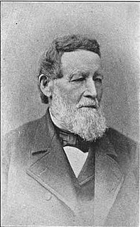
Amory Maynard (1804–1890) was a textile manufacturer who was the namesake of Maynard, Massachusetts.
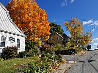
Presidential Village is a residential neighborhood of approximately 250 houses in Maynard, Massachusetts where almost all of the streets are named after the post-American Civil War U.S. Presidents: Ulysses Grant, Rutherford Hayes, James Garfield, Chester Arthur, Grover Cleveland, Benjamin Harrison, William McKinley, and Theodore Roosevelt. Across from Harrison Street is the Coolidge Park Playground and former Calvin Coolidge School (1905), named after President Calvin Coolidge in 1932.

White Pond is a 58.5 acre lake and reservoir within the towns of Stow and Hudson, in Middlesex County, Massachusetts. The lake has historically provided a source of drinking water to the town of Maynard, and Maynard maintains water rights to the pond and owns some of the land surrounding it. White Pond is adjacent to Lake Boon but their waters are not connected.


