Townsend (CDP), Massachusetts

Last updated
Townsend, Massachusetts
Townsend MA Common.jpg
Townsend Common
Middlesex County Massachusetts incorporated and unincorporated areas Townsend (CDP) highlighted.svg
Location in Middlesex County in Massachusetts
Coordinates: 42°40′4″N71°42′22″W / 42.66778°N 71.70611°W / 42.66778; -71.70611 Coordinates: 42°40′4″N71°42′22″W / 42.66778°N 71.70611°W / 42.66778; -71.70611
Country United States
State Massachusetts
County Middlesex
Area
[1]
  Total1.72 sq mi (4.47 km2)
  Land1.69 sq mi (4.39 km2)
  Water0.03 sq mi (0.08 km2)
Elevation
315 ft (96 m)
Population
 (2020)
  Total1,213
  Density716.06/sq mi (276.51/km2)
Time zone UTC-5 (Eastern (EST))
  Summer (DST) UTC-4 (EDT)
ZIP codes
01469, 01474
Area code(s) 978
FIPS code 25-70325
GNIS feature ID0610801

Townsend is a census-designated place (CDP) in the town of Townsend in Middlesex County, Massachusetts, United States. The population was 1,128 at the 2010 census. [2]

Contents

Geography

Townsend is located at 42°40′3″N71°42′21″W / 42.66750°N 71.70583°W / 42.66750; -71.70583 (42.667688, -71.706019). [3]

According to the United States Census Bureau, the CDP has a total area of 4.5 km2 (1.7 mi2). 4.4 km2 (1.7 mi2) of it is land and 0.1 km2 (0.04 mi2) of it (2.33%) is water.

Demographics

Historical population
CensusPop.
2020 1,213
U.S. Decennial Census [4]

As of the census [5] of 2000, there were 1,043 people, 441 households, and 262 families residing in the CDP The population density was 239.7/km2 (620.2/mi2). There were 455 housing units at an average density of 104.6/km2 (270.5/mi2). The racial makeup of the CDP was 96.84% White, 0.48% Black or African American, 0.67% Native American, 0.29% from other races, and 1.73% from two or more races. Hispanic or Latino of any race were 1.15% of the population.

There were 441 households, out of which 32.7% had children under the age of 18 living with them, 43.3% were married couples living together, 12.9% had a female householder with no husband present, and 40.4% were non-families. 35.8% of all households were made up of individuals, and 17.5% had someone living alone who was 65 years of age or older. The average household size was 2.37 and the average family size was 3.12.

In the CDP, the population was spread out, with 26.8% under the age of 18, 8.5% from 18 to 24, 29.6% from 25 to 44, 21.7% from 45 to 64, and 13.3% who were 65 years of age or older. The median age was 37 years. For every 100 females, there were 81.4 males. For every 100 females age 18 and over, there were 83.0 males.

The median income for a household in the CDP was $50,234, and the median income for a family was $59,500. Males had a median income of $39,813 versus $26,439 for females. The per capita income for the CDP was $25,272. None of the families and 3.3% of the population were living below the poverty line, including no under eighteens and 7.8% of those over 64.

Related Research Articles

Sunset, Florida CDP in Florida, United States

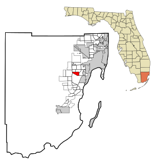
Sunset is a census-designated place (CDP) and affluent neighborhood in Miami-Dade County, Florida, United States. The population was 16,389 at the 2010 census. The zip-codes serving Sunset are 33173, 33183, and 33193.

South Dennis, Massachusetts Census-designated place in Massachusetts, United States

South Dennis is a census-designated place (CDP) in the town of Dennis in Barnstable County, Massachusetts, United States. The population was 3,643 at the 2010 census, the most of the 5 CDPs in Dennis.

East Pepperell, Massachusetts Census-designated place in Massachusetts, United States

East Pepperell is a census-designated place (CDP) in the town of Pepperell in Middlesex County, Massachusetts, United States. The population was 2,059 at the 2010 census.

Littleton Common, Massachusetts Census-designated place in Massachusetts, United States

Littleton Common is a census-designated place (CDP) in the town of Littleton in Middlesex County, Massachusetts, United States. The population was 2,789 at the 2010 census.

East Douglas, Massachusetts CDP in Massachusetts, United States

East Douglas is a census-designated place (CDP) in the town of Douglas in Worcester County, Massachusetts, United States. The population was 2,557 at the 2010 census.

South Ashburnham, Massachusetts CDP in Massachusetts, United States

South Ashburnham is a census-designated place (CDP) in the town of Ashburnham in Worcester County, Massachusetts, United States. The population was 1,062 at the 2010 census.

East Atlantic Beach, New York Hamlet and census-designated place in New York, United States

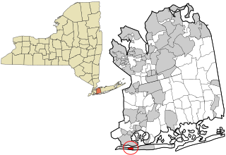
East Atlantic Beach is a hamlet and census-designated place (CDP) in Nassau County, New York, United States. The population was 2,049 at the 2010 census. The unincorporated hamlet is governed by the Town of Hempstead, one of three towns in Nassau County.

Ayer (CDP), Massachusetts Census-designated place in Massachusetts, United States

Ayer is a census-designated place (CDP) in the town of Ayer in Middlesex County, Massachusetts, United States. The population was 2,868 at the 2010 census.

Lunenburg (CDP), Massachusetts CDP in Massachusetts, United States

Lunenburg is a census-designated place (CDP) in the town of Lunenburg in Worcester County, Massachusetts, United States. The population was 1,760 at the 2010 census.

Oxford (CDP), Massachusetts CDP in Massachusetts, United States

Oxford is a census-designated place (CDP) in the town of Oxford in Worcester County, Massachusetts, United States. The population was 6,103 at the 2010 census.

Rutland (CDP), Massachusetts CDP in Massachusetts, United States

Rutland is a census-designated place (CDP) in the town of Rutland in Worcester County, Massachusetts, United States. The population was 2,111 at the 2010 census.

Warren (CDP), Massachusetts CDP in Massachusetts, United States

Warren is a census-designated place (CDP) in the town of Warren in Worcester County, Massachusetts, United States. The population was 1,405 at the 2010 census.

Webster (CDP), Massachusetts CDP in Massachusetts, United States

Webster is a census-designated place (CDP) in the town of Webster in Worcester County, Massachusetts, United States. The population was 11,412 at the 2010 census.

Groton (CDP), Massachusetts Census-designated place in Massachusetts, United States

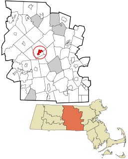
Groton is a census-designated place (CDP) in the town of Groton in Middlesex County, Massachusetts, United States. The population was 1,124 at the 2010 census.

Hudson (CDP), Massachusetts Census-designated place in Massachusetts, United States

Hudson is a census-designated place (CDP) in the town of Hudson in Middlesex County, Massachusetts, United States. The population was 14,907 at the 2010 census.

Pepperell (CDP), Massachusetts Census-designated place in Massachusetts, United States

Pepperell is a census-designated place (CDP) in the town of Pepperell in Middlesex County, Massachusetts, United States. The population was 2,504 at the 2010 census.

Shirley (CDP), Massachusetts Census-designated place in Massachusetts, United States

Shirley is a census-designated place (CDP) in the town of Shirley in Middlesex County, Massachusetts, United States. The population was 1,441 at the 2010 census.

Bellingham (CDP), Massachusetts CDP in Massachusetts, United States

Bellingham is a census-designated place (CDP) in the town of Bellingham in Norfolk County, Massachusetts, United States. The population was 4,854 at the 2010 census.

Dover (CDP), Massachusetts CDP in Massachusetts, United States

Dover is a census-designated place (CDP) in the town of Dover in Norfolk County, Massachusetts, United States. The population was 2,265 at the 2010 census.

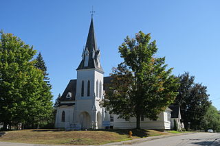
Millinocket is a census-designated place (CDP) comprising most of the developed land within the town of Millinocket in Penobscot County, Maine, United States. The population of the CDP was 4,466 at the 2010 census.

References

  1. "2020 U.S. Gazetteer Files". United States Census Bureau. Retrieved May 21, 2022.
  2. "Profile of General Population and Housing Characteristics: 2010 Demographic Profile Data (DP-1): Townsend CDP, Massachusetts". United States Census Bureau . Retrieved April 10, 2012.
  3. "US Gazetteer files: 2010, 2000, and 1990". United States Census Bureau. 2011-02-12. Retrieved 2011-04-23.
  4. "Census of Population and Housing". Census.gov. Retrieved June 4, 2016.
  5. "U.S. Census website". United States Census Bureau . Retrieved 2008-01-31.