Millbury, Massachusetts

Last updated

Millbury, Massachusetts
Millbury Center, Millbury, MA.jpg
View of Millbury in circa 1905.
Seal of Millbury, Massachusetts.png
Worcester County Massachusetts incorporated and unincorporated areas Millbury highlighted.svg
Location in Worcester County and the state of Massachusetts.
Coordinates: 42°11′38″N71°45′38″W / 42.19389°N 71.76056°W / 42.19389; -71.76056
Country United States
State Massachusetts
County Worcester
Settled1716
Incorporated 1813
Government
  Type Open town meeting
   Town
   Manager
Sean Hendricks
Area
  Total16.3 sq mi (42.1 km2)
  Land15.7 sq mi (40.7 km2)
  Water0.5 sq mi (1.3 km2)
Elevation
417 ft (127 m)
Population
 (2020)
  Total13,831
  Density850/sq mi (330/km2)
Time zone UTC−5 (Eastern)
  Summer (DST) UTC−4 (Eastern)
ZIP Code
01527
Area code 508/774
FIPS code 25-41340
GNIS feature ID0618373
Website www.millbury-ma.org

Millbury, officially the Town of Millbury, is a town in Worcester County, Massachusetts, United States. Located within Blackstone Valley, the population in Millbury was 13,831 at the 2020 United States Census. [1]

Contents

History

Millbury was first settled by Europeans in 1716. It was originally known as the Second or North Parish of Sutton. Because traveling from one part of the town to the other for meetings was time-consuming, inhabitants of the North Parish petitioned the Massachusetts General Court to split Sutton. North Parish became Millbury on June 11, 1813, by way of an act of incorporation. [2] Its name derived from its long history as a mill town. The Blackstone River flows through the town, and during the Industrial Revolution, provided water power to its many textile mills and factories. During this time, the inventor William Crompton worked in Millbury.

Millbury's industrial history begins in the early eighteenth century, not long after the area's settlement. In 1735, John Singletary began operating a mill on Singletary Brook, a stream flowing out of Singletary Lake. Around 1753, Singletary built the S & D Spinning Mill, which is still in operation, making it one of the oldest continuously operated mills in the United States. The mill is featured on the Town Seal. The mill also makes the inner parts of the Rawlings baseballs for use in Major League Baseball. [3]

In the late eighteenth and early nineteenth centuries, after learning the trade of firearms production from their father, Asa Waters and his brother, Elijah, purchased land along the Blackstone River and built mills producing goods such as guns, scythes, and sawmill equipment. In 1808, they erected an armory, which was successful until forced to close suddenly in 1841. It reopened at the start of the American Civil War in 1861. With the wealth received from the industry, Asa began construction of the Asa Waters Mansion in 1826. Designed by local architect Asher Benjamin, it was completed six years later.

Louise Taft, mother of United States President William Howard Taft, resided in Millbury for many years, and President Taft spent many summer vacations in the town during his youth. He visited his aunt, Delia C. Torrey, during his presidency to celebrate Millbury's centennial. The Torrey House, where President Taft stayed, is now commonly called the Taft House.

In 1824, the mineral called Vermiculite was first found in Millbury.

Due to the Flood Control Act of 1944, the Worcester Flood Diversion Channel was constructed in that year within Millbury, as well as nearby Auburn.

In the early 1970s, Millbury experienced a number of large fires. The town hall burned down, followed by the Union School. A propane plant near Route 146 exploded, causing considerable damage and making nationwide news.

In 2004, Millbury was designated as a Preserve America community. [4]

Millbury celebrated its bicentennial in 2013. The local Vaillancourt Folk Art designed chalkware for the celebration. Later that year, a proposal for a casino was made, but the related development company pulled out when it became clear that a large majority of inhabitants were against the proposal. [5]

Geography

According to the United States Census Bureau, Millbury has a total area of 16.3 square miles (42 km2), of which 15.7 square miles (41 km2) is land and 0.5 square miles (1.3 km2), or 3.20%, is water. The town is within the Blackstone Valley and is drained by the Blackstone River.[ citation needed ]

Historic places

Millbury has three sites on the National Register of Historic Places:

Demographics

As of the census [17] of 2020, there were 13,831 people, 4,927 households, and 3,443 families residing in the town. The population density was 812.5 inhabitants per square mile (313.7/km2). There were 5,109 housing units at an average density of 324.7 per square mile (125.4/km2). The racial makeup of the town was 97.19% White, 0.53% African American, 0.15% Native American, 1.02% Asian, 0.03% Pacific Islander, 0.23% from other races, and 0.84% from two or more races. Hispanic or Latino of any race were 1.02% of the population.

There were 4,927 households, out of which 30.2% had children under the age of 18 living with them, 55.7% were married couples living together, 10.9% had a female householder with no husband present, and 30.1% were non-families. Of all households, 24.6% were made up of individuals, and 10.3% had someone living alone who was 65 years of age or older. The average household size was 2.53 and the average family size was 3.03.

In the town, the population was spread out, with 23.1% under the age of 18, 6.3% from 18 to 24, 31.2% from 25 to 44, 23.4% from 45 to 64, and 16.0% who were 65 years of age or older. The median age was 39 years. For every 100 females, there were 93.3 males. For every 100 females age 18 and over, there were 88.4 males.

The median income for a household in the town was $51,415, and the median income for a family was $62,564. Males had a median income of $41,912 versus $28,973 for females. The per capita income for the town was $23,531. About 4.1% of families and 6.3% of the population were below the poverty line, including 8.2% of those under age 18 and 8.4% of those age 65 or over

Education

Millbury Public Library in the snow in 2008. Millbury Public Library in the Snow 01.jpg
Millbury Public Library in the snow in 2008.

In 1826, the first formal lyceum school was founded by Josiah Holbrook in Millbury.

Public schools in Millbury fall under the jurisdiction of Millbury Public Schools school district. Approximately 2,000 students are educated in three schools: Elmwood Street School, (grades Pre-K through 2); Raymond E. Shaw Elementary School (grades 3 through 6); and Millbury Memorial Junior/Senior High School (grades 7 through 12). [18]

Millbury Public Library opened in 1864. [19] In fiscal year 2008, the town spent 1.15% ($358,097) of its budget on the library.

Government

State government
State Representative(s):Paul K. Frost (R)
State Senator(s): Michael O. Moore (D)
Governor's Councilor(s):Paul DePalo (D)
Federal government
U.S. Representative(s): Jim McGovern (D)
U.S. Senators: Elizabeth Warren (D), Ed Markey (D)

Notable people

The Torrey House in 2012. 122 Elm Street - Millbury, MA - DSC04577.JPG
The Torrey House in 2012.

See also

Related Research Articles

<span class="mw-page-title-main">Worcester County, Massachusetts</span> County in Massachusetts, United States

Worcester County is a county in the U.S. state of Massachusetts. At the 2020 census, the population was 862,111, making it the second-most populous county in Massachusetts. It is also the largest county in Massachusetts by geographic area. The largest city and traditional shire town is Worcester. Worcester County is part of the Worcester, MA–CT metropolitan statistical area and the Boston-Worcester-Providence combined statistical area.

<span class="mw-page-title-main">Monson, Massachusetts</span> Town in Massachusetts, United States

Monson is a town in Hampden County, Massachusetts, United States. The population was 8,150 at the 2020 census. It is part of the Springfield, Massachusetts Metropolitan Statistical Area.

<span class="mw-page-title-main">Medway, Massachusetts</span> Town in Massachusetts, United States

Medway is a town in Norfolk County, Massachusetts, United States. The town had a population of 13,115 at the 2020 census.

<span class="mw-page-title-main">Berlin, Massachusetts</span> Town in Massachusetts, United States

Berlin is a town in Worcester County, Massachusetts, United States. The town was first settled in 1665 and incorporated in 1812, and is governed under the open town meeting system. It is located 12 miles (19 km) northeast of Worcester and 29 miles (47 km) west of Boston. The population was 3,158 at the 2020 census.

<span class="mw-page-title-main">Blackstone, Massachusetts</span> Town in Massachusetts, United States

Blackstone is a town in Worcester County, Massachusetts, United States. The population was 9,208 at the 2020 census. It is a part of the Providence metropolitan area.

<span class="mw-page-title-main">Douglas, Massachusetts</span> Town in Massachusetts, United States

Douglas is a town in Southern Worcester County, Massachusetts, United States. The population was 8,983 at the 2020 census. It includes the sizable Douglas State Forest, managed by the Department of Conservation and Recreation (DCR).

<span class="mw-page-title-main">Grafton, Massachusetts</span> Town in Massachusetts, United States

Grafton is a town in Worcester County, Massachusetts, United States. The population was 19,664 at the 2020 census. The town consists of the North Grafton, Grafton, and South Grafton geographic areas, each with a separate ZIP Code. Incorporated in 1735, the town is home to a Nipmuc village known as Hassanamisco Reservation, the Willard House and Clock Museum, Community Harvest Project, and the Tufts University Cummings School of Veterinary Medicine. Grafton operates the state's largest on-call fire department, with 74 members.

<span class="mw-page-title-main">Mendon, Massachusetts</span> Town in Massachusetts, United States

Mendon is a town in Worcester County, Massachusetts, United States. The population was 6,228 at the 2020 census. Mendon is part of the Blackstone River Valley National Heritage Corridor, an early center of the industrial revolution in the United States. Mendon celebrated its 350th anniversary on May 15, 2017.

<span class="mw-page-title-main">Millville, Massachusetts</span> Town in Massachusetts, United States

Millville is a town in Worcester County, Massachusetts, United States. The population was 3,174 at the 2020 census. It is part of the Providence metropolitan area.

<span class="mw-page-title-main">Northbridge, Massachusetts</span> Town in Massachusetts, United States

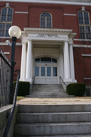
Northbridge is a town in Worcester County, Massachusetts, United States. The population was 16,335 at the 2020 census. The Northbridge Town Hall is located at 7 Main Street in Whitinsville. The town is now a part of the Blackstone River Valley National Heritage Corridor, of the National Park Service. Northbridge claims to history include: Native American Nipmuc lands, Colonel John Spring, who led the Uxbridge militia training company in the American Revolution, Samuel Spring, Revolutionary War Chaplain, the Residence of Ezra T. Benson 1830–1832, the birthplace of President Millard Fillmore's mother, Phoebe, and home to the Whitin Machine Works from 1831 to 1964.

<span class="mw-page-title-main">Phillipston, Massachusetts</span> Town in Massachusetts, United States

Phillipston is a town in Worcester County, Massachusetts, United States. The population was 1,724 at the 2020 census.

<span class="mw-page-title-main">Sutton, Massachusetts</span> Town in Massachusetts, United States

Sutton, officially the Town of Sutton, is a town in Worcester County, Massachusetts, United States. The population was 9,357 in the 2020 United States Census. Located in the Blackstone Valley, the town was designated as a Preserve America community in 2004.

<span class="mw-page-title-main">Upton, Massachusetts</span> Town in Massachusetts, United States

Upton is a town in Worcester County, Massachusetts, United States. It was first settled in 1728. The population was given as exactly 8,000 at the 2020 census.

<span class="mw-page-title-main">Uxbridge, Massachusetts</span> Town in Massachusetts, United States

Uxbridge is a town in Worcester County, Massachusetts, United States, first colonized in 1662 and incorporated in 1727. It was originally part of the town of Mendon, and named for the Earl of Uxbridge. The town is located 36 mi (58 km) southwest of Boston and 15 mi (24 km) south-southeast of Worcester, at the midpoint of the Blackstone Valley National Historic Park. The historical society notes that Uxbridge is the "Heart of The Blackstone Valley" and is also known as "the Cradle of the Industrial Revolution". Uxbridge was a prominent Textile center in the American Industrial Revolution. Two Quakers served as national leaders in the American anti-slavery movement. Uxbridge "weaves a tapestry of early America".

<span class="mw-page-title-main">Hopedale, Massachusetts</span> Town in Massachusetts, United States

Hopedale is a town in Worcester County, Massachusetts, United States. It is located 25 miles southwest of Boston, in eastern Massachusetts. With origins as a Christian utopian community, the town was later home to Draper Corporation, a large loom manufacturer throughout the 20th century until its closure in 1980. Today, Hopedale has become a bedroom community for professionals working in Greater Boston and is home to highly ranked public schools. The population was 6,017 as of the 2020 census.

<span class="mw-page-title-main">Milford, Massachusetts</span> Town in Massachusetts, United States

Milford is a town in Worcester County, Massachusetts, United States. The population was 30,379 according to the 2020 census. First settled in 1662 and incorporated in 1780, Milford became a booming industrial and quarrying community in the 19th century due to its unique location which includes the nearby source of the Charles River, the Mill River, the Blackstone River watershed, and large quantities of Milford pink granite.

<span class="mw-page-title-main">Oxford, Massachusetts</span> Town in Massachusetts, United States

Oxford is a town in Worcester County, Massachusetts, United States. The population was 13,347 as of the 2020 United States Census.

<span class="mw-page-title-main">Sturbridge, Massachusetts</span> Town in Massachusetts, United States

Sturbridge is a town in Worcester County, Massachusetts, United States. It is home to Old Sturbridge Village living history museum and other sites of historical interest such as Tantiusques.

<span class="mw-page-title-main">Webster, Massachusetts</span> Town in Massachusetts, United States

Webster is a town in Worcester County, Massachusetts, United States. The population was 17,776 at the 2020 census.

<span class="mw-page-title-main">Bellingham, Massachusetts</span> Town in Massachusetts, United States

Bellingham is a town in Norfolk County, Massachusetts, United States. The population was 16,945 at the 2020 census. The town sits on the southwestern fringe of Metropolitan Boston, along the rapidly growing "outer belt" that is Interstate 495. It is formally a part of the Boston–Cambridge–Quincy metropolitan statistical area, as well as the Providence metropolitan area.

References

  1. "QuickFacts Millbury town, Worcester County, Massachusetts". Census.gov. October 15, 2021.
  2. History of the Town of Sutton, Massachusetts, from 1704 to 1876
  3. Ballou, Bill (July 12, 2015). "Major league baseballs get start in Millbury". telegram.com. Retrieved March 13, 2019.
  4. "Millbury, Massachusetts | Advisory Council on Historic Preservation".
  5. Worcester Telegram and Gazette
  6. "Total Population (P1), 2010 Census Summary File 1". American FactFinder, All County Subdivisions within Massachusetts. United States Census Bureau. 2010.
  7. "Massachusetts by Place and County Subdivision - GCT-T1. Population Estimates". United States Census Bureau. Retrieved July 12, 2011.
  8. "1990 Census of Population, General Population Characteristics: Massachusetts" (PDF). US Census Bureau. December 1990. Table 76: General Characteristics of Persons, Households, and Families: 1990. 1990 CP-1-23. Retrieved July 12, 2011.
  9. "1980 Census of the Population, Number of Inhabitants: Massachusetts" (PDF). US Census Bureau. December 1981. Table 4. Populations of County Subdivisions: 1960 to 1980. PC80-1-A23. Retrieved July 12, 2011.
  10. "1950 Census of Population" (PDF). Bureau of the Census. 1952. Section 6, Pages 21-10 and 21-11, Massachusetts Table 6. Population of Counties by Minor Civil Divisions: 1930 to 1950. Retrieved July 12, 2011.
  11. "1920 Census of Population" (PDF). Bureau of the Census. Number of Inhabitants, by Counties and Minor Civil Divisions. Pages 21-5 through 21-7. Massachusetts Table 2. Population of Counties by Minor Civil Divisions: 1920, 1910, and 1920. Retrieved July 12, 2011.
  12. "1890 Census of the Population" (PDF). Department of the Interior, Census Office. Pages 179 through 182. Massachusetts Table 5. Population of States and Territories by Minor Civil Divisions: 1880 and 1890. Retrieved July 12, 2011.
  13. "1870 Census of the Population" (PDF). Department of the Interior, Census Office. 1872. Pages 217 through 220. Table IX. Population of Minor Civil Divisions, &c. Massachusetts. Retrieved July 12, 2011.
  14. "1860 Census" (PDF). Department of the Interior, Census Office. 1864. Pages 220 through 226. State of Massachusetts Table No. 3. Populations of Cities, Towns, &c. Retrieved July 12, 2011.
  15. "1850 Census" (PDF). Department of the Interior, Census Office. 1854. Pages 338 through 393. Populations of Cities, Towns, &c. Retrieved July 12, 2011.
  16. "City and Town Population Totals: 2020-2022". United States Census Bureau . Retrieved October 29, 2023.
  17. "U.S. Census website". United States Census Bureau . Retrieved January 31, 2008.
  18. Millbury Public Schools
  19. C.B. Tillinghast. The free public libraries of Massachusetts. 1st Report of the Free Public Library Commission of Massachusetts. Boston: Wright & Potter, 1891. In 1915, the architect William H. McLean designed the library building. Google books