East Brookfield (CDP), Massachusetts

Last updated

East Brookfield, Massachusetts
CDP
East Main Street, East Brookfield MA.jpg
East Main Street
Worcester County Massachusetts incorporated and unincorporated areas East Brookfield (CDP) highlighted.svg
Location in Worcester County and the state of Massachusetts.
Coordinates: 42°13′44″N72°3′3″W / 42.22889°N 72.05083°W / 42.22889; -72.05083
Country United States
State Massachusetts
County Worcester
Area
[1]
  Total1.77 sq mi (4.59 km2)
  Land1.62 sq mi (4.19 km2)
  Water0.16 sq mi (0.40 km2)
Elevation
614 ft (187 m)
Population
 (2020)
  Total1,292
  Density798.52/sq mi (308.30/km2)
Time zone UTC-5 (Eastern (EST))
  Summer (DST) UTC-4 (EDT)
ZIP code
01515
Area code 508
FIPS code 25-18595
GNIS feature ID0609799

East Brookfield is a census-designated place (CDP) in the town of East Brookfield in Worcester County, Massachusetts, United States. The population was 1,323 at the 2010 census.

Contents

Geography

East Brookfield is located at 42°13′44″N72°3′2″W / 42.22889°N 72.05056°W / 42.22889; -72.05056 (42.228952, -72.050795). [2]

According to the United States Census Bureau, the CDP has a total area of 4.6 km2 (1.8 mi2), of which 4.2 km2 (1.6 mi2) is land and 0.4 km2 (0.2 mi2) (8.43%) is water.

Demographics

Historical population
CensusPop.Note
2020 1,292
U.S. Decennial Census [3]

As of the census [4] of 2000, there were 1,410 people, 527 households, and 394 families residing in the CDP. The population density was 332.0/km2 (861.8/mi2). There were 563 housing units at an average density of 132.5/km2 (344.1/mi2). The racial makeup of the CDP was 98.87% White, 0.21% Black or African American, 0.07% Native American, 0.14% Asian, 0.14% from other races, and 0.57% from two or more races. Hispanic or Latino of any race were 0.78% of the population.

There were 527 households, out of which 30.7% had children under the age of 18 living with them, 63.0% were married couples living together, 8.5% had a female householder with no husband present, and 25.2% were non-families. 20.9% of all households were made up of individuals, and 11.8% had someone living alone who was 65 years of age or older. The average household size was 2.68 and the average family size was 3.09.

In the CDP, the population was spread out, with 25.5% under the age of 18, 6.2% from 18 to 24, 30.1% from 25 to 44, 24.0% from 45 to 64, and 14.2% who were 65 years of age or older. The median age was 39 years. For every 100 females, there were 96.9 males. For every 100 females age 18 and over, there were 94.4 males.

The median income for a household in the CDP was $50,774, and the median income for a family was $60,000. Males had a median income of $42,305 versus $26,563 for females. The per capita income for the CDP was $22,161. About 3.9% of families and 4.5% of the population were below the poverty line, including 3.8% of those under age 18 and 12.2% of those age 65 or over.

Related Research Articles

<span class="mw-page-title-main">Three Rivers, Massachusetts</span> Former CDP in Massachusetts, United States

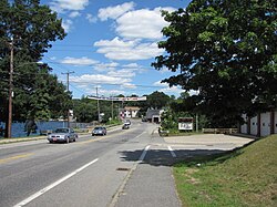
Three Rivers is a village and former census-designated place (CDP) in the city of Palmer in Hampden County, Massachusetts, United States. It is part of the Springfield, Massachusetts Metropolitan Statistical Area. It is named for the confluence of the Ware and Quaboag rivers, which form the Chicopee River.

<span class="mw-page-title-main">North Pembroke, Massachusetts</span> Census-designated place in Massachusetts, United States

North Pembroke is a census-designated place (CDP) in the town of Pembroke in Plymouth County, Massachusetts, United States. The population was 3,292 at the 2010 census.

<span class="mw-page-title-main">Baldwinville, Massachusetts</span> CDP in Massachusetts, United States

Baldwinville is an unincorporated village and census-designated place (CDP) in the town of Templeton in Worcester County, Massachusetts, United States. The population was 2,028 at the 2010 census. The name also refers to the local post office or railroad station.

<span class="mw-page-title-main">East Douglas, Massachusetts</span> CDP in Massachusetts, United States

East Douglas is a census-designated place (CDP) in the town of Douglas in Worcester County, Massachusetts, United States. The population was 2,557 at the 2010 census.

<span class="mw-page-title-main">Fiskdale, Massachusetts</span> CDP in Sturbridge, Massachusetts, United States

Fiskdale is a census-designated place (CDP) in the town of Sturbridge in Worcester County, Massachusetts, United States. The population was 2,583 at the 2010 census.

<span class="mw-page-title-main">Brookfield Center, Ohio</span> Census-designated place in Ohio, United States

Brookfield Center, also referred to as simply Brookfield, is an unincorporated community and census-designated place in central Brookfield Township, Trumbull County, Ohio, United States. The population was 1,141 at the 2020 census. It is part of the Youngstown–Warren metropolitan area.

<span class="mw-page-title-main">Orange (CDP), Massachusetts</span> Census-designated place in Massachusetts, United States

Orange is a census-designated place (CDP) in the town of Orange in Franklin County, Massachusetts, United States. The population was 4,018 at the 2010 census. It is part of the Springfield, Massachusetts Metropolitan Statistical Area.

<span class="mw-page-title-main">Holland (CDP), Massachusetts</span> Census-designated place in Massachusetts, United States

Holland is a census-designated place (CDP) in the town of Holland in Hampden County, Massachusetts, United States, comprising the town center and other populated areas in the eastern part of the town. The population was 1,464 at the 2010 census, out of a total 2,481 people in the town. It is part of the Springfield, Massachusetts Metropolitan Statistical Area.

<span class="mw-page-title-main">Palmer (CDP), Massachusetts</span> Former CDP in Massachusetts, United States

Palmer is former census-designated place (CDP) in Hampden County, Massachusetts, United States. The population was 3,900 at the 2000 census. It is part of the Springfield, Massachusetts Metropolitan Statistical Area. The area is more commonly known as Depot Village, named for the ornate train depot built there by famed architect H.H. Richardson

<span class="mw-page-title-main">Ware (CDP), Massachusetts</span> Census-designated place in Massachusetts, United States

Ware is a census-designated place (CDP) comprising the main village in the town of Ware in Hampshire County, Massachusetts, United States. The population of the CDP was 6,170 at the 2010 census, out of a total town population of 9,872. It is part of the Springfield, Massachusetts Metropolitan Statistical Area.

<span class="mw-page-title-main">Duxbury (CDP), Massachusetts</span> Census-designated place in Massachusetts, United States

Duxbury is a census-designated place (CDP) in the town of Duxbury in Plymouth County, Massachusetts, United States. The population was 1,802 at the 2010 census.

<span class="mw-page-title-main">Hingham (CDP), Massachusetts</span> Census-designated place in Massachusetts, United States

Hingham is a census-designated place (CDP) in the town of Hingham in Plymouth County, Massachusetts, United States. The population was 5,650 at the 2010 census.

<span class="mw-page-title-main">Marshfield (CDP), Massachusetts</span> Census-designated place in Massachusetts, United States

Marshfield is a census-designated place (CDP) in the town of Marshfield in Plymouth County, Massachusetts, United States. The population was 4,335 at the 2010 census.

<span class="mw-page-title-main">Athol (CDP), Massachusetts</span> CDP in Massachusetts, United States

Athol is a census-designated place (CDP) in the town of Athol in Worcester County, Massachusetts, United States. The population was 8,265 at the 2010 census.

<span class="mw-page-title-main">Milford (CDP), Massachusetts</span> CDP in Massachusetts, United States

Milford is a census-designated place (CDP) in the town of Milford in Worcester County, Massachusetts, United States. The population was 25,055 at the 2010 census.

<span class="mw-page-title-main">North Brookfield (CDP), Massachusetts</span> CDP in Massachusetts, United States

North Brookfield is a census-designated place (CDP) in the town of North Brookfield in Worcester County, Massachusetts, United States. The population was 2,265 at the 2010 census.

<span class="mw-page-title-main">Sturbridge (CDP), Massachusetts</span> CDP in Massachusetts, United States

Sturbridge is a census-designated place (CDP) in the town of Sturbridge in Worcester County, Massachusetts, United States. The population was 2,253 at the 2010 census.

<span class="mw-page-title-main">Warren (CDP), Massachusetts</span> CDP in Massachusetts, United States

Warren is a census-designated place (CDP) in the town of Warren in Worcester County, Massachusetts, United States. The population was 1,405 at the 2010 census.

<span class="mw-page-title-main">West Brookfield (CDP), Massachusetts</span> Census-designated place in Massachusetts, United States

West Brookfield is a census-designated place (CDP) in the town of West Brookfield in Worcester County, Massachusetts, United States. The population was 1,413 at the 2010 census.

<span class="mw-page-title-main">Winchendon (CDP), Massachusetts</span> Census-designated place in Massachusetts, United States

Winchendon is a census-designated place (CDP) in the town of Winchendon in Worcester County, Massachusetts, United States. The population was 4,160 at the 2020 census.

References

  1. "2020 U.S. Gazetteer Files". United States Census Bureau. Retrieved May 21, 2022.
  2. "US Gazetteer files: 2010, 2000, and 1990". United States Census Bureau. February 12, 2011. Retrieved April 23, 2011.
  3. "Census of Population and Housing". Census.gov. Retrieved June 4, 2016.
  4. "U.S. Census website". United States Census Bureau . Retrieved January 31, 2008.