Paxton, Massachusetts

Last updated

Paxton, Massachusetts
Paxton mass town hall.jpg
Paxton Town Hall
Seal of Paxton, Massachusetts.png
Worcester County Massachusetts incorporated and unincorporated areas Paxton highlighted.svg
Location in Worcester County and the state of Massachusetts.
Coordinates: 42°18′40″N71°55′43″W / 42.31111°N 71.92861°W / 42.31111; -71.92861
Country United States
State Massachusetts
County Worcester
Settled1749
Incorporated1765
Government
  Type Open town meeting
   Town
   Administrator
Heather Munroe [1]
  Board of
   Selectmen
Peter Bogren, Jr.
John F. Malone
Julia Pingitore
Area
  Total15.5 sq mi (40.1 km2)
  Land14.7 sq mi (38.2 km2)
  Water0.7 sq mi (1.9 km2)
Elevation
1,158 ft (353 m)
Population
 (2020)
  Total5,004
  Density320/sq mi (120/km2)
Time zone UTC-5 (Eastern)
  Summer (DST) UTC-4 (Eastern)
ZIP code
01612
Area code 508 / 774
FIPS code 25-52420
GNIS feature ID0619485
Website Town of Paxton, Massachusetts

Paxton is a town in Worcester County, Massachusetts, United States. The population was 5,004 at the 2020 census. [2]

Contents

History

Paxton center church at night Paxton Church Night.jpg
Paxton center church at night

Paxton was first settled by Europeans in 1749 and was officially incorporated in 1765. It was previously occupied by the Nipmuc tribe.

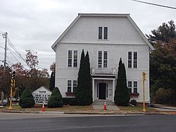
The district of Paxton was originally taken from the towns of Leicester and Rutland, in nearly equal parts, and was incorporated February 12, 1765. Charles Paxton, marshal of the Admiralty Court, offered a church bell to the town if it was named after him; no such gift was ever made. [3] [4] The inhabitants soon commenced their plan for building a meeting house, and on the first day of April 1765, the town voted to build it. It was raised on June 18, 1766, and this is the frame of the present meeting house.

In 1766, within two years of the incorporation of the town, the foundation of the present meeting house was laid, on what is now the common, near the flagstaff. The land was given by Seth Howe, from a piece of his pasture.

David Davis went to Boston with a pair of oxen and drew to Paxton the bell now in use, which was made by Paul Revere.

A small historic and now defunct amusement park called "Paxton Navy Yard" operated here in the mid 20th century.

Asnebumskit Hill was the site of the Yankee Network's early FM broadcasting antenna, beginning its commercial operations in Summer 1939. [5]

Geography

According to the United States Census Bureau, the town has a total area of 15.5 square miles (40 km2), of which 14.7 square miles (38 km2) is land and 0.7 square miles (1.8 km2), or 4.78%, is water.

Adjacent cities and towns

Demographics

As of the census [17] of 2000, there were 4,386 people, 1,428 households, and 1,153 families residing in the town. The population density was 297.7 inhabitants per square mile (114.9/km2). There were 1,461 housing units at an average density of 99.2 per square mile (38.3/km2). The racial makeup of the town was 96.69% White, 0.68% African American, 0.09% Native American, 1.07% Asian, 0.57% from other races, and 0.89% from two or more races. Hispanic or Latino of any race were 1.55% of the population.

There were 1,428 households, out of which 36.1% had children under the age of 18 living with them, 72.1% were married couples living together, 6.0% had a female householder with no husband present, and 19.2% were non-families. 15.7% of all households were made up of individuals, and 8.3% had someone living alone who was 65 years of age or older. The average household size was 2.79 and the average family size was 3.13.

In the town, the population was spread out, with 23.9% under the age of 18, 13.6% from 18 to 24, 23.9% from 25 to 44, 24.0% from 45 to 64, and 14.6% who were 65 years of age or older. The median age was 38 years. For every 100 females, there were 91.5 males. For every 100 females age 18 and over, there were 87.0 males.

The median income for a household in the town was $72,039, and the median income for a family was $80,498. Males had a median income of $51,694 versus $38,409 for females. The per capita income for the town was $29,573. None of the families and 1.8% of the population were living below the poverty line, including no under eighteens and 4.5% of those over 64.

State government
State Representative(s):Kimberly N. Ferguson (R)
State Senator(s):Anne Gobi (D)
Governor's Councilor(s):Jen Caissie (R)
Federal government
U.S. Representative(s): James P. McGovern (D-2nd District)
U.S. Senators: Elizabeth Warren (D), Ed Markey (D)

Arts and culture

Points of interest

Education

Library

The Paxton public library began in 1877. [18] [19] In fiscal year 2008, the town of Paxton spent 1.53% ($143,354) of its budget on its public library—approximately $30 per person ($36.74 adjusted for inflation to 2021). [20]

Infrastructure

Paxton civil war memorial Paxton mass civil war memorial.jpg
Paxton civil war memorial

Utilities

Notable people

See also

Related Research Articles

<span class="mw-page-title-main">Boylston, Massachusetts</span> Town in Massachusetts, United States

Boylston is a town in Worcester County, Massachusetts, United States. The population was 4,849 at the 2020 census.

<span class="mw-page-title-main">Charlton, Massachusetts</span> Town in Massachusetts, United States

Charlton is a town in Worcester County, Massachusetts, United States. The population was 13,315 at the 2020 census.

<span class="mw-page-title-main">Dudley, Massachusetts</span> Town in Massachusetts, United States

Dudley is a town in Worcester County, Massachusetts, United States. The population was 11,921 at the 2020 census.

<span class="mw-page-title-main">Holden, Massachusetts</span> Town in Massachusetts, United States

Holden is a town in Worcester County, Massachusetts, United States. The town was founded in 1741, and the Town Square was donated by John Hancock, former Governor of Massachusetts. The population was 19,905 at the 2020 census.

<span class="mw-page-title-main">Hubbardston, Massachusetts</span> Town in Massachusetts, United States

Hubbardston is a town in Worcester County, Massachusetts, United States. As of the 2020 U.S. census, the town population was 4,328. It is situated 18 miles north of Worcester and 53 miles west of Boston; it is distinguished in Massachusetts by being unusually high, at 1015 feet above sea level.

<span class="mw-page-title-main">Lancaster, Massachusetts</span> Town in Massachusetts, United States

Lancaster is a town in Worcester County, Massachusetts, United States. Incorporated in 1653, Lancaster is the oldest town in Worcester County. As of the 2020 census, the town population was 8,441.

<span class="mw-page-title-main">Leicester, Massachusetts</span> Town in Massachusetts, United States

Leicester is a town in Worcester County, Massachusetts, United States. The population was 11,087 at the 2020 United States Census.

<span class="mw-page-title-main">Millbury, Massachusetts</span> Town in Massachusetts, United States

Millbury, officially the Town of Millbury, is a town in Worcester County, Massachusetts, United States. Located within Blackstone Valley, the population in Millbury was 13,831 at the 2020 United States Census.

<span class="mw-page-title-main">Oakham, Massachusetts</span> Town in Massachusetts, United States

Oakham is a town in Worcester County, Massachusetts, United States. The population was 1,851 at the 2020 census.

<span class="mw-page-title-main">Petersham, Massachusetts</span> Town in Massachusetts, United States

Petersham is a town in Worcester County, Massachusetts, United States. The population was 1,194 at the 2020 census. Petersham is home to a considerable amount of conservation land, including the Quabbin Reservation, Harvard Forest, the Swift River Reservation, and Federated Women's Club State Forest.

<span class="mw-page-title-main">Phillipston, Massachusetts</span> Town in Massachusetts, United States

Phillipston is a town in Worcester County, Massachusetts, United States. The population was 1,724 at the 2020 census.

<span class="mw-page-title-main">Princeton, Massachusetts</span> Town in Massachusetts, United States

Princeton is a town in Worcester County, Massachusetts, United States. It is bordered on the east by Sterling and Leominster, on the north by Westminster, on the northwest by Hubbardston, on the southwest by Rutland, and on the southeast by Holden. The preeminent landmark within Princeton is Mount Wachusett, which straddles the line between Princeton and Westminster but the entrance to which is within Princeton. According to tradition, in 1675, Mary Rowlandson was ransomed upon Redemption Rock, now within the town of Princeton, by King Philip. The population was 3,495 at the 2020 census. Princeton is a rural exurb, serving as a bedroom commuter town for nearby cities such as Worcester, Gardner, and Boston.

<span class="mw-page-title-main">Sterling, Massachusetts</span> Town in Massachusetts, United States

Sterling is a town in Worcester County, Massachusetts, United States. The population was 7,985 at the 2020 census.

<span class="mw-page-title-main">Templeton, Massachusetts</span> Town in Massachusetts, United States

Templeton is a town in Worcester County, Massachusetts, United States. The population was 8,149 at the 2020 census. The town comprises four main villages: Templeton Center, East Templeton, Baldwinville, and Otter River.

<span class="mw-page-title-main">Westminster, Massachusetts</span> Town in Massachusetts, United States

Westminster is a town in Worcester County, Massachusetts, United States. At the 2020 census, the town population was 8,213.

<span class="mw-page-title-main">West Brookfield, Massachusetts</span> Town in Massachusetts, United States

West Brookfield is a town in Worcester County, Massachusetts, United States. The population was 3,833 at the 2020 census. Lucy Stone was born in West Brookfield, and George and Charles Merriam, the publishers of Webster's Dictionary, were raised there.

<span class="mw-page-title-main">Clinton, Massachusetts</span> Town in Massachusetts, United States

Clinton is a town in Worcester County, Massachusetts, United States. The population was 15,428 at the 2020 census.

<span class="mw-page-title-main">Oxford, Massachusetts</span> Town in Massachusetts, United States

Oxford is a town in Worcester County, Massachusetts, United States. The population was 13,347 as of the 2020 United States Census.

<span class="mw-page-title-main">Rutland, Massachusetts</span> Town in Massachusetts, United States

Rutland is a town in Worcester County, Massachusetts, United States. The population was 9,049 at the 2020 census. Rutland is the geographic center of Massachusetts; a tree, the Central Tree, located on Central Tree Road, marks the general spot.

<span class="mw-page-title-main">North Brookfield, Massachusetts</span> Town in Massachusetts, United States

North Brookfield is a town in Worcester County, Massachusetts, United States. The population was 4,735 at the 2020 census.

References

  1. https://www.townofpaxton.net/town-administrator
  2. "Census - Geography Profile: Paxton town, Worcester County, Massachusetts". United States Census Bureau . Retrieved November 12, 2021.
  3. "Profile for Paxton, Massachusetts, MA". ePodunk. Archived from the original on December 9, 2018. Retrieved October 23, 2015.
  4. "What's in a name? The story behind Paxton". The Landmark. Retrieved June 26, 2013.
  5. Lawrence Lessing (1969), Man of High Fidelity: Edwin Howard Armstrong , revised edition, New York: Bantam, Ch.12, "The Defender of the Human Ear", pp. 194-195.
  6. "Total Population (P1), 2010 Census Summary File 1". American FactFinder, All County Subdivisions within Massachusetts. United States Census Bureau. 2010.
  7. "Massachusetts by Place and County Subdivision - GCT-T1. Population Estimates". United States Census Bureau. Retrieved July 12, 2011.
  8. "1990 Census of Population, General Population Characteristics: Massachusetts" (PDF). US Census Bureau. December 1990. Table 76: General Characteristics of Persons, Households, and Families: 1990. 1990 CP-1-23. Retrieved July 12, 2011.
  9. "1980 Census of the Population, Number of Inhabitants: Massachusetts" (PDF). US Census Bureau. December 1981. Table 4. Populations of County Subdivisions: 1960 to 1980. PC80-1-A23. Retrieved July 12, 2011.
  10. "1950 Census of Population" (PDF). Bureau of the Census. 1952. Section 6, Pages 21-10 and 21-11, Massachusetts Table 6. Population of Counties by Minor Civil Divisions: 1930 to 1950. Retrieved July 12, 2011.
  11. "1920 Census of Population" (PDF). Bureau of the Census. Number of Inhabitants, by Counties and Minor Civil Divisions. Pages 21-5 through 21-7. Massachusetts Table 2. Population of Counties by Minor Civil Divisions: 1920, 1910, and 1920. Retrieved July 12, 2011.
  12. "1890 Census of the Population" (PDF). Department of the Interior, Census Office. Pages 179 through 182. Massachusetts Table 5. Population of States and Territories by Minor Civil Divisions: 1880 and 1890. Retrieved July 12, 2011.
  13. "1870 Census of the Population" (PDF). Department of the Interior, Census Office. 1872. Pages 217 through 220. Table IX. Population of Minor Civil Divisions, &c. Massachusetts. Retrieved July 12, 2011.
  14. "1860 Census" (PDF). Department of the Interior, Census Office. 1864. Pages 220 through 226. State of Massachusetts Table No. 3. Populations of Cities, Towns, &c. Retrieved July 12, 2011.
  15. "1850 Census" (PDF). Department of the Interior, Census Office. 1854. Pages 338 through 393. Populations of Cities, Towns, &c. Retrieved July 12, 2011.
  16. "City and Town Population Totals: 2020-2022". United States Census Bureau . Retrieved November 3, 2023.
  17. "U.S. Census website". United States Census Bureau . Retrieved January 31, 2008.
  18. C.B. Tillinghast. The free public libraries of Massachusetts. 1st Report of the Free Public Library Commission of Massachusetts. Boston: Wright & Potter, 1891. Google books
  19. Richards Memorial Library. Retrieved November 10, 2010
  20. July 1, 2007, through June 30, 2008; cf. The FY2008 Municipal Pie: What's Your Share? Commonwealth of Massachusetts, Board of Library Commissioners. Boston: 2009. Available: Municipal Pie Reports Archived January 23, 2012, at the Wayback Machine . Retrieved August 4, 2010