
Worcester County is a county in the U.S. state of Massachusetts. At the 2020 census, the population was 862,111, making it the second-most populous county in Massachusetts. It is also the largest county in Massachusetts by geographic area. The largest city and traditional shire town is Worcester. Worcester County is part of the Worcester, MA–CT metropolitan statistical area and as the Boston–Worcester–Providence, MA–RI–NH–CT combined statistical area.

Brookfield is a town in Worcester County, Massachusetts, United States. Brookfield was first settled by Europeans in 1660. The population was 3,439 at the 2020 census.

Hardwick is a town in Worcester County, Massachusetts, United States, about 20 miles (32 km) west of the city of Worcester. It had a population of 2,667 at the 2020 census. It includes the villages of Hardwick, Gilbertville, Wheelwright and Old Furnace.

Mendon is a town in Worcester County, Massachusetts, United States. The population was 6,228 at the 2020 census. Mendon is part of the Blackstone River Valley National Heritage Corridor, an early center of the industrial revolution in the United States. Mendon celebrated its 350th anniversary on May 15, 2017.

Upton is a town in Worcester County, Massachusetts, United States. It was first settled in 1728. The population was given as exactly 8,000 at the 2020 census.

Mason is a town in Hillsborough County, New Hampshire, United States. The population was 1,448 at the 2020 census. Mason, together with Wilton, is home to Russell-Abbott State Forest.
Orange is a town in Franklin County, Massachusetts, United States. The population was 7,569 at the 2020 census. It is part of the Springfield, Massachusetts Metropolitan Statistical Area.

Ware is a census-designated place (CDP) comprising the main village in the town of Ware in Hampshire County, Massachusetts, United States. The population of the CDP was 6,170 at the 2010 census, out of a total town population of 9,872. It is part of the Springfield, Massachusetts Metropolitan Statistical Area.

Hopedale is a town in Worcester County, Massachusetts, United States. It is located 25 miles southwest of Boston, in eastern Massachusetts. With origins as a Christian utopian community, the town was later home to Draper Corporation, a large loom manufacturer throughout the 20th century until its closure in 1980. Today, Hopedale has become a bedroom community for professionals working in Greater Boston and is home to highly ranked public schools. The population was 6,017 as of the 2020 census.

Milford is a town in Worcester County, Massachusetts, United States. The population was 30,379 according to the 2020 census. First settled in 1662 and incorporated in 1780, Milford became a booming industrial and quarrying community in the 19th century due to its unique location which includes the nearby source of the Charles River, the Mill River, the Blackstone River watershed, and large quantities of Milford pink granite.

Sturbridge is a town in Worcester County, Massachusetts, United States. It is home to Old Sturbridge Village living history museum and other sites of historical interest such as Tantiusques.

Milford is a census-designated place (CDP) and the main village in the town of Milford, Hillsborough County, New Hampshire, United States. The population of the CDP was 9,212 at the 2020 census, out of 16,131 in the entire town.

Route 140 is a 107.76-mile-long (173.42 km) north—south state highway which passes through Bristol, Norfolk and Worcester counties in Massachusetts. The highway follows a southeast-northwest trajectory, running from U.S. Route 6 in New Bedford just north of Buzzards Bay northwest to an intersection with Route 12 in Winchendon, a few miles south of the border with New Hampshire.
West Warren is a census-designated place (CDP) and village in the town of Warren, Worcester County, Massachusetts, United States. It sits on the north side of the Quaboag River along Massachusetts Route 67, 2.5 miles (4.0 km) west of Warren village and 9 miles (14 km) northeast of Palmer.
East Worcester is a hamlet and census-designated place (CDP) in the town of Worcester in Otsego County, New York, United States. It was first listed as a CDP prior to the 2020 census.

Hudson is a census-designated place (CDP) comprising the densely developed central part of the town of Hudson in Middlesex County, Massachusetts, United States. The population of the CDP was 15,749 at the 2020 census, out of 20,092 in the entire town.

Bellingham is a town in Norfolk County, Massachusetts, United States. The population was 16,945 at the 2020 census. The town sits on the southwestern fringe of Metropolitan Boston, along the rapidly growing "outer belt" that is Interstate 495. It is formally a part of the Boston–Cambridge–Quincy metropolitan statistical area, as well as the Providence metropolitan area.

Huntington is a census-designated place (CDP) comprising the main village in the town of Huntington in Hampshire County, Massachusetts, United States. The population of the CDP was 936 at the 2010 census, out of a total town population of 2,180. It is part of the Springfield, Massachusetts Metropolitan Statistical Area.
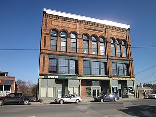
Brookfield is a census-designated place (CDP) comprising the main village in the town of Brookfield, Worcester County, Massachusetts, United States. Massachusetts Route 9 passes through the center of the village, leading east 6 miles (10 km) to Spencer and west 9 miles (14 km) to Ware. Massachusetts Route 148 crosses Route 9 in the village center, leading north 4 miles (6 km) to North Brookfield and south 7 miles (11 km) to Fiskdale.
Petersham is a census-designated place (CDP) comprising the main village in the town of Petersham, Worcester County, Massachusetts, United States. Massachusetts Route 32 passes through the village, leading north 9 miles (14 km) to Athol and southeast 7 miles (11 km) to Barre. Massachusetts Route 122 joins Route 32 in the village center, leading southeast with it to Barre but northwest 11 miles (18 km) to Orange.


