Sutton, Massachusetts

Last updated

Sutton, Massachusetts
Sutton Common.jpg
Partial view of the Sutton Center Historic District in 2007.
Seal of Sutton, Massachusetts.png
Worcester County Massachusetts incorporated and unincorporated areas Sutton highlighted.svg
Location in Worcester County and the state of Massachusetts.
Coordinates: 42°09′00″N71°45′48″W / 42.15000°N 71.76333°W / 42.15000; -71.76333
Country United States
State Massachusetts
County Worcester
Settled1704
Incorporated1714
Government
  Type Open town meeting
   Town
   Manager
James Smith
  Board of
   Selectmen
David Hall
Jesse Limanek
Wendy Mead
Jonathan Anderson
Jeff Bannon
Area
  Total33.9 sq mi (87.9 km2)
  Land32.4 sq mi (83.9 km2)
  Water1.6 sq mi (4.0 km2)
Elevation
706 ft (215 m)
Population
 (2020)
  Total9,357
  Density280/sq mi (110/km2)
Time zone UTC−5 (Eastern)
  Summer (DST) UTC−4 (Eastern)
ZIP Code
01590
Area code 508/774
FIPS code 25-68610
GNIS feature ID0619491
Website www.suttonma.org

Sutton, officially the Town of Sutton, is a town in Worcester County, Massachusetts, United States. The population was 9,357 in the 2020 United States Census. [1] Located in the Blackstone Valley, the town was designated as a Preserve America community in 2004. [2]

Contents

History

A Nipmuc, John Wampas, visited England in the 1600s and deeded land in the Sutton area to Edward Pratt, who later sold interests to others. Competing claims involving the Nipmucs led to a Massachusetts General Court case in 1704, which granted Pratt and fellow proprietors an eight-mile-square section of land, which is now Sutton. [3]

Three families were the first to settle in Sutton, namely those of Elisha Johnson, Nathaniel Johnson, and Benjamin Marsh, who is credited as a founder of the town and the First Baptist Church of Sutton. In 1717, The Great Snow completely buried structures their home cabins. According to accounts, a local Indigenous person rescued the Johnson family by noticing smoke from their chimney through the snow. Marsh served in several capacities for the town including as a selectman and moderator. He also served as elder and pastor from 1737 until his death in 1775. [4]

By 1735, area inhabited by Hassanamisco Nipmuc and a small portion of the northeastern Sutton had incorporated as the town of Grafton. In 1813, the northern part of Sutton became Millbury.

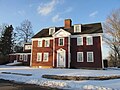
In 1737, the Edward Putnam House, one of the oldest homes in Sutton, was built by its namesake and cousin of the military officer Rufus Putnam. The house is featured on the town seal. [5]

On September 26, 1777, Holman's Regiment of Militia was called up in Sutton during the American Revolutionary War.

Since 1962, the Pleasant Valley Country Club has hosted a number of notable Professional Golfers' Association of America tournaments such as the Booz Allen Classic, the Lady Carling Eastern Open, and the New England Classic. The 1968-67 and 1970-74 Women's PGA Championship took place at Pleasant Valley. From 1965 to 1973, golfer Paul Harney worked there.

In 1984, Vaillancourt Folk Art, noted makers of chalkware, was established in Sutton.

In 2004, Sutton was designated as a Preserve America community. [6]

Geography

According to the United States Census Bureau, the town has a total area of 33.9 square miles (88 km2), of which 32.4 square miles (84 km2) is land and 1.5 square miles (3.9 km2), or 4.57%, is water.

The town contains five villages, known as Manchaug, South Sutton, Sutton Center, West Sutton, and Wilkinsonville. Located in the Blackstone Valley, Sutton shares its borders with the towns of Douglas, Grafton, Millbury, Northbridge, Oxford, and Uxbridge.

Historic places

Sutton has seven sites on the National Register of Historic Places:

Climate

Climate data for Sutton, Massachusetts
MonthJanFebMarAprMayJunJulAugSepOctNovDecYear
Record high °F (°C)64
(18)
73
(23)
83
(28)
91
(33)
95
(35)
97
(36)
98
(37)
98
(37)
95
(35)
87
(31)
79
(26)
72
(22)
98
(37)
Mean daily maximum °F (°C)34
(1)
37
(3)
45
(7)
57
(14)
68
(20)
77
(25)
81
(27)
80
(27)
73
(23)
61
(16)
51
(11)
38
(3)
59
(15)
Mean daily minimum °F (°C)12
(−11)
15
(−9)
23
(−5)
34
(1)
44
(7)
54
(12)
60
(16)
58
(14)
49
(9)
37
(3)
30
(−1)
19
(−7)
36
(2)
Record low °F (°C)−28
(−33)
−22
(−30)
−16
(−27)
2
(−17)
25
(−4)
34
(1)
40
(4)
34
(1)
9
(−13)
16
(−9)
−2
(−19)
−16
(−27)
−28
(−33)
Average precipitation inches (mm)3.76
(96)
3.39
(86)
4.45
(113)
4.39
(112)
3.73
(95)
4.15
(105)
4.30
(109)
3.78
(96)
3.88
(99)
4.61
(117)
4.49
(114)
3.87
(98)
48.8
(1,240)
Source: [7]

Demographics

Historical population
YearPop.±%
1850 2,595    
1860 2,676+3.1%
1870 2,699+0.9%
1880 3,105+15.0%
1890 3,180+2.4%
1900 3,328+4.7%
1910 3,078−7.5%
1920 2,578−16.2%
1930 2,147−16.7%
1940 2,749+28.0%
1950 3,102+12.8%
1960 3,638+17.3%
1970 4,590+26.2%
1980 5,855+27.6%
1990 6,824+16.5%
2000 8,250+20.9%
2010 8,963+8.6%
2020 9,357+4.4%
2022*9,379+0.2%
* = population estimate.
Source: United States census records and Population Estimates Program data. [8] [9] [10] [11] [12] [13] [14] [15] [16] [17] [18]

As of the 2010 U.S. Census there were 8,963 people residing in Sutton. As of the census [19] of 2000, there were 8,250 people, 2,811 households, and 2,282 families residing in the town. The population density was 254.8 inhabitants per square mile (98.4/km2). There were 2,950 housing units at an average density of 91.1 per square mile (35.2/km2). The racial makeup of the town was 98.18% White, 0.68% African American, 0.01% Native American, 0.59% Asian, 0.27% from other races, and 0.55% from two or more races. Hispanic or Latino of any race were 0.70% of the population.

There were 2,811 households, out of which 42.3% had children under the age of 18 living with them, 71.3% were married couples living together, 6.8% had a female householder with no husband present, and 18.8% were non-families. Of all households, 15.0% were made up of individuals, and 6.2% had someone living alone who was 65 years of age or older. The average household size was 2.93 and the average family size was 3.27.

In the town, the population was spread out, with 29.4% under the age of 18, 5.6% from 18 to 24, 31.5% from 25 to 44, 25.4% from 45 to 64, and 8.1% who were 65 years of age or older. The median age was 36 years. For every 100 females, there were 99.3 males. For every 100 females age 18 and over, there were 97.1 males.

The median income for a household in the town was $75,141, and the median income for a family was $81,000. Males had a median income of $53,482 versus $37,463 for females. The per capita income for the town was $27,490. About 3.4% of families and 4.4% of the population were below the poverty line, including 5.2% of those under age 18 and 6.8% of those age 65 or over.

Government

Sutton has an open town meeting type government. The current Town Moderator is Ken Stuart, who served as a Selectman prior to his election in 2015.

The town government in Sutton consists of the Town Manager and the Board of Selectmen. The current Town Manager is James A. Smith, and the current members of the Board of Selectmen are David Hall (since Oct 2012), Jesse Limanek (since May 2015), Wendy Mead (since May 2018), Jonathan Anderson (since Oct 2018), and Jeff Bannon (since May 2019).

The public services in Sutton include the police, fire, and highway departments. The Police Department is located at 489 Central Turnpike. The Fire Department has three stations, one in the center of town, one in the Wilkinsonville village, and one in the Manchaug village. The Sutton Highway Department is located at 25 Pleasant Valley Road. [20]

Education

Public schools in Sutton fall under the jurisdiction of Sutton Public School District. Sutton public schools consist of the Simonian Center for Early Learning, Sutton Elementary School, Sutton Middle School, and Sutton High School.

The Sutton Free Library was established in 1876. [21] [22] In fiscal year 2008, the town of Sutton spent 0.7% ($165,982) of its budget on its public library—approximately $18 per person, per year ($23.72 adjusted for inflation to 2022). [23]

Notable people

See also

Related Research Articles

<span class="mw-page-title-main">Gill, Massachusetts</span> Town in Massachusetts, United States

Gill is a town in Franklin County, Massachusetts, United States. The population was 1,551 at the 2020 census. It is part of the Springfield, Massachusetts Metropolitan Statistical Area. The campus of Northfield Mount Hermon School is located in the Mount Hermon section of the town.

<span class="mw-page-title-main">Blackstone, Massachusetts</span> Town in Massachusetts, United States

Blackstone is a town in Worcester County, Massachusetts, United States. The population was 9,208 at the 2020 census. It is a part of the Providence metropolitan area.

<span class="mw-page-title-main">Douglas, Massachusetts</span> Town in Massachusetts, United States

Douglas is a town in Southern Worcester County, Massachusetts, United States. The population was 8,983 at the 2020 census. It includes the sizable Douglas State Forest, managed by the Department of Conservation and Recreation (DCR).

<span class="mw-page-title-main">Grafton, Massachusetts</span> Town in Massachusetts, United States

Grafton is a town in Worcester County, Massachusetts, United States. The population was 19,664 at the 2020 census. The town consists of the North Grafton, Grafton, and South Grafton geographic areas, each with a separate ZIP Code. Incorporated in 1735, the town is home to a Nipmuc village known as Hassanamisco Reservation, the Willard House and Clock Museum, Community Harvest Project, and the Tufts University Cummings School of Veterinary Medicine. Grafton operates the state's largest on-call fire department, with 74 members.

<span class="mw-page-title-main">Mendon, Massachusetts</span> Town in Massachusetts, United States

Mendon is a town in Worcester County, Massachusetts, United States. The population was 6,228 at the 2020 census. Mendon is part of the Blackstone River Valley National Heritage Corridor, an early center of the industrial revolution in the United States. Mendon celebrated its 350th anniversary on May 15, 2017.

<span class="mw-page-title-main">Millbury, Massachusetts</span> Town in Massachusetts, United States

Millbury, officially the Town of Millbury, is a town in Worcester County, Massachusetts, United States. Located within Blackstone Valley, the population in Millbury was 13,831 at the 2020 United States Census.

<span class="mw-page-title-main">Millville, Massachusetts</span> Town in Massachusetts, United States

Millville is a town in Worcester County, Massachusetts, United States. The population was 3,174 at the 2020 census. It is part of the Providence metropolitan area.

<span class="mw-page-title-main">Northbridge, Massachusetts</span> Town in Massachusetts, United States

Northbridge is a town in Worcester County, Massachusetts, United States. The population was 16,335 at the 2020 census. The Northbridge Town Hall is located at 7 Main Street in Whitinsville. The town is now a part of the Blackstone River Valley National Heritage Corridor, of the National Park Service. Northbridge claims to history include: Native American Nipmuc lands, Colonel John Spring, who led the Uxbridge militia training company in the American Revolution, Samuel Spring, Revolutionary War Chaplain, the Residence of Ezra T. Benson 1830–1832, the birthplace of President Millard Fillmore's mother, Phoebe, and home to the Whitin Machine Works from 1831 to 1964.

<span class="mw-page-title-main">Paxton, Massachusetts</span> Town in Massachusetts, United States

Paxton is a town in Worcester County, Massachusetts, United States. The population was 5,004 at the 2020 census.

<span class="mw-page-title-main">Royalston, Massachusetts</span> Town in Massachusetts, United States

Royalston is a town in Worcester County, Massachusetts, United States. The population was 1,250 at the 2020 census.

<span class="mw-page-title-main">Upton, Massachusetts</span> Town in Massachusetts, United States

Upton is a town in Worcester County, Massachusetts, United States. It was first settled in 1728. The population was given as exactly 8,000 at the 2020 census.

<span class="mw-page-title-main">Burrillville, Rhode Island</span> Town in Rhode Island, United States

Burrillville is a town in Providence County, Rhode Island, United States. The population was 16,158 at the 2020 census.

<span class="mw-page-title-main">Woonsocket, Rhode Island</span> City in Rhode Island, United States

Woonsocket, is a city in Providence County, Rhode Island, United States. The population was 43,240 at the 2020 census, making it the sixth largest city in the state. Being Rhode Island's northernmost city, Woonsocket lies directly south of the Massachusetts state line and constitutes part of both the Providence metropolitan area and the larger Greater Boston Combined Statistical Area.

<span class="mw-page-title-main">Northfield, Massachusetts</span> Town in Massachusetts, United States

Northfield is a town in Franklin County, Massachusetts, United States. Northfield was first settled in 1673. The population was 2,866 at the 2020 census. It is part of the Springfield, Massachusetts Metropolitan Statistical Area. The Connecticut River runs through the town, dividing West Northfield from East Northfield and the village of Northfield, where the town hall is located.

<span class="mw-page-title-main">Hopedale, Massachusetts</span> Town in Massachusetts, United States

Hopedale is a town in Worcester County, Massachusetts, United States. It is located 25 miles southwest of Boston, in eastern Massachusetts. With origins as a Christian utopian community, the town was later home to Draper Corporation, a large loom manufacturer throughout the 20th century until its closure in 1980. Today, Hopedale has become a bedroom community for professionals working in Greater Boston and is home to highly ranked public schools. The population was 6,017 as of the 2020 census.

<span class="mw-page-title-main">Milford, Massachusetts</span> Town in Massachusetts, United States

Milford is a town in Worcester County, Massachusetts, United States. The population was 30,379 according to the 2020 census. First settled in 1662 and incorporated in 1780, Milford became a booming industrial and quarrying community in the 19th century due to its unique location which includes the nearby source of the Charles River, the Mill River, the Blackstone River watershed, and large quantities of Milford pink granite.

<span class="mw-page-title-main">Oxford, Massachusetts</span> Town in Massachusetts, United States

Oxford is a town in Worcester County, Massachusetts, United States. The population was 13,347 as of the 2020 United States Census.

<span class="mw-page-title-main">Webster, Massachusetts</span> Town in Massachusetts, United States

Webster is a town in Worcester County, Massachusetts, United States. The population was 17,776 at the 2020 census.

<span class="mw-page-title-main">Rutland, Massachusetts</span> Town in Massachusetts, United States

Rutland is a town in Worcester County, Massachusetts, United States. The population was 9,049 at the 2020 census. Rutland is the geographic center of Massachusetts; a tree, the Central Tree, located on Central Tree Road, marks the general spot.

<span class="mw-page-title-main">Northborough, Massachusetts</span> Town in Massachusetts, United States

Northborough is a town in Worcester County, Massachusetts, United States. The official spelling of the town's name is "Northborough," but the alternative spelling "Northboro" is also used. The population was 15,741 at the 2020 census.

References

  1. "Census - Geography Profile: Sutton town, Worcester County, Massachusetts". United States Census Bureau . Retrieved November 11, 2021.
  2. "Sutton, Massachusetts | Advisory Council on Historic Preservation".
  3. "History of Sutton". suttonma.org. Retrieved January 24, 2011.
  4. Marsh, William H. III, History of our Marsh Family, p. 9, Bremerhaven, Germany, 1978.
  5. Hubbard, Robert Ernest. General Rufus Putnam: George Washington's Chief Military Engineer and the "Father of Ohio," pp. 6-8, 192, McFarland & Company, Inc., Jefferson, North Carolina. ISBN   978-1-4766-7862-7.
  6. "Sutton, Massachusetts | Advisory Council on Historic Preservation".
  7. "Sutton, MA Monthly Weather". www.weather.com. Retrieved August 29, 2020.
  8. "Total Population (P1), 2010 Census Summary File 1". American FactFinder, All County Subdivisions within Massachusetts. United States Census Bureau. 2010.
  9. "Massachusetts by Place and County Subdivision - GCT-T1. Population Estimates". United States Census Bureau. Retrieved July 12, 2011.
  10. "1990 Census of Population, General Population Characteristics: Massachusetts" (PDF). US Census Bureau. December 1990. Table 76: General Characteristics of Persons, Households, and Families: 1990. 1990 CP-1-23. Retrieved July 12, 2011.
  11. "1980 Census of the Population, Number of Inhabitants: Massachusetts" (PDF). US Census Bureau. December 1981. Table 4. Populations of County Subdivisions: 1960 to 1980. PC80-1-A23. Retrieved July 12, 2011.
  12. "1950 Census of Population" (PDF). Bureau of the Census. 1952. Section 6, Pages 21-10 and 21-11, Massachusetts Table 6. Population of Counties by Minor Civil Divisions: 1930 to 1950. Retrieved July 12, 2011.
  13. "1920 Census of Population" (PDF). Bureau of the Census. Number of Inhabitants, by Counties and Minor Civil Divisions. Pages 21-5 through 21-7. Massachusetts Table 2. Population of Counties by Minor Civil Divisions: 1920, 1910, and 1920. Retrieved July 12, 2011.
  14. "1890 Census of the Population" (PDF). Department of the Interior, Census Office. Pages 179 through 182. Massachusetts Table 5. Population of States and Territories by Minor Civil Divisions: 1880 and 1890. Retrieved July 12, 2011.
  15. "1870 Census of the Population" (PDF). Department of the Interior, Census Office. 1872. Pages 217 through 220. Table IX. Population of Minor Civil Divisions, &c. Massachusetts. Retrieved July 12, 2011.
  16. "1860 Census" (PDF). Department of the Interior, Census Office. 1864. Pages 220 through 226. State of Massachusetts Table No. 3. Populations of Cities, Towns, &c. Retrieved July 12, 2011.
  17. "1850 Census" (PDF). Department of the Interior, Census Office. 1854. Pages 338 through 393. Populations of Cities, Towns, &c. Retrieved July 12, 2011.
  18. "City and Town Population Totals: 2020-2022". United States Census Bureau . Retrieved November 4, 2023.
  19. "U.S. Census website". United States Census Bureau . Retrieved January 31, 2008.
  20. MA, Sutton. "Sutton, MA". suttonma.org. Retrieved April 15, 2018.
  21. C.B. Tillinghast. The free public libraries of Massachusetts. 1st Report of the Free Public Library Commission of Massachusetts. Boston: Wright & Potter, 1891.
  22. Sutton Public Library. Retrieved November 10, 2010
  23. July 1, 2007, through June 30, 2008; cf. The FY2008 Municipal Pie: What's Your Share? Commonwealth of Massachusetts, Board of Library Commissioners. Boston: 2009. Available: Municipal Pie Reports Archived January 23, 2012, at the Wayback Machine . Retrieved August 4, 2010