
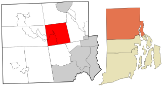
North Smithfield is a town in Providence County, Rhode Island, United States, settled as a farming community in 1666 and incorporated into its present form in 1871. North Smithfield includes the historic villages of Forestdale, Primrose, Waterford, Branch Village, Union Village, Park Square, and Slatersville. The population was 12,588 at the 2020 census.
Smithfield is a town that is located in Providence County, Rhode Island, United States. It includes the historic villages of Esmond, Georgiaville, Mountaindale, Hanton City, Stillwater and Greenville. The population was 22,118 at the 2020 census. Smithfield is the home of Bryant University, a private four year college.

Woonsocket, is a city in Providence County, Rhode Island, United States. The population was 43,240 at the 2020 census, making it the sixth largest city in the state. Being Rhode Island's northernmost city, Woonsocket lies directly south of the Massachusetts state line and constitutes part of both the Providence metropolitan area and the larger Greater Boston Combined Statistical Area.

Peleg Arnold (1751–1820) was a lawyer, tavern-keeper, jurist, and statesman from Smithfield, Rhode Island. He represented Rhode Island as a delegate to the Continental Congress in the 1787–1788 session. He later served as the chief justice of the Rhode Island Supreme Court from June 1795 to June 1809, and from May 1810 to May 1812.

Route 146 is a 20.99-mile (33.78 km) north-south state highway in the U.S. state of Massachusetts, maintained by the Massachusetts Department of Transportation (MassDOT). Spanning approximately 21 miles (34 km) along a south–north axis, it is a continuation of Rhode Island Route 146, which splits from I-95 in Providence. The southern terminus within Massachusetts exists in Millville, where it enters the state from North Smithfield, Rhode Island. Among several local roads, Route 146 intersects with the Massachusetts Turnpike (I-90) in Millbury and I-290 in Worcester before arriving at its northern terminus at the intersection of several surface streets in downtown Worcester. Most of the route is a freeway, except for a short section near the boundary between Millbury and Sutton where there is driveway access and at-grade crossings.

Route 99, also known as the Woonsocket Industrial Highway, is a 2.9-mile-long (4.7 km) freeway in Providence County, Rhode Island, United States. Route 99 serves Manville and the Highland Industrial Park, providing freeway access to the city of Woonsocket from Rhode Island Route 146, which bypasses the city. The southern terminus of Route 99 is at a partial interchange with Route 146 in Lincoln. The freeway has one interchange in Manville, a village in Lincoln, before terminating at an at-grade intersection with Rhode Island Route 122 in Woonsocket.

Route 146 is a 16.24-mile (26.14 km) north-south state highway in the U.S. state of Rhode Island, maintained by the Rhode Island Department of Transportation (RIDOT). Spanning approximately 16 miles (26 km) along a northwest–southeast axis, it links the cities of Providence, Woonsocket, and Worcester, Massachusetts.

Thomas Alexander Tefft was an American architect, from Providence, Rhode Island. Tefft, one of the nation's first professionally trained architects, is considered a master of Rundbogenstil and a leading American proponent of its use. Prior to his untimely death, Tefft "offered the most advanced designs of [his] day in America"

Slatersville is a village on the Branch River in the town of North Smithfield, Rhode Island, United States. It includes the Slatersville Historic District, a historic district listed on the National Register of Historic Places. The historic district has been included as part of the Blackstone River Valley National Historical Park. The North Smithfield Public Library is located in Slatersville.

The Friends Meetinghouse is an historic Friends Meeting House of the Religious Society of Friends (Quakers) located at the junction of Routes 146A and 98 in Uxbridge, Massachusetts. On January 24, 1974, it was added to the National Register of Historic Places.

Saylesville is a village and historic district in Lincoln, Rhode Island, United States.
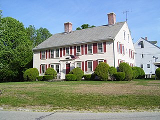
The Peleg Arnold Tavern off Great Road in Union Village in North Smithfield, Rhode Island was built around 1690 and is one of the oldest homes in North Smithfield. The oldest part of house was built in the late 17th century by Richard Arnold, one of the earliest settlers in the area. His descendant, Peleg Arnold, greatly expanded the building a century later. Peleg Arnold was a justice of the Rhode Island Supreme Court and representative to the Continental Congress. Arnold's popular tavern served as center of American military operations in the town during the American Revolution. The house was added to the National Register of Historic Places in 1974.

The Smithfield Friends Meeting House, Parsonage and Cemetery, is a Friends Meeting House of the Religious Society of Friends (Quakers), rebuilt in 1881. It is located at 108 Smithfield Road in Woonsocket, Rhode Island. The meetinghouse is home to one of the oldest Quaker communities in the region.

The 1761 Milestone is a mile marker located at 640 South Main Street in Woonsocket, Rhode Island. The stone originally marked the junction of a Colonial highway from Great Road and an east–west route from Boston, Massachusetts to Connecticut. It was rediscovered during the installation of an electrical road. In 1898, it was restored to its original location by the local chapter of the Daughters of the American Revolution. The stone is embedded in a low retaining wall at the corner of South Main Street and Smithfield Road. It was added to the National Register of Historic Places on November 24, 1982, and is historically significant as a Colonial-era highway marker.

The Saylesville Friends Meetinghouse is an historic Quaker meetinghouse located at 374 Great Road within the village of Saylesville in the town of Lincoln, Rhode Island.
The history of Uxbridge, Massachusetts, founded in 1727, may be divided into its prehistory, its colonial history and its modern industrial history. Uxbridge is located on the Massachusetts-Rhode Island state line, and became a center of the earliest industrialized region in the United States.
Richard Mowry became an Uxbridge farmer, in Worcester County, Massachusetts, United States who "successfully built and marketed equipment to manufacture woolen, linen or cotton cloth", from around the time of the Revolution.


