Fiskdale, Massachusetts

Last updated

Fiskdale, Massachusetts
CDP
Blackington Building, Fiskdale MA.jpg
Blackington Building
Worcester County Massachusetts incorporated and unincorporated areas Fiskdale highlighted.svg
Location in Worcester County and the state of Massachusetts.
Coordinates: 42°6′54″N72°6′42″W / 42.11500°N 72.11167°W / 42.11500; -72.11167
Country United States
State Massachusetts
County Worcester
Area
[1]
  Total3.31 sq mi (8.58 km2)
  Land3.17 sq mi (8.21 km2)
  Water0.14 sq mi (0.37 km2)
Elevation
627 ft (191 m)
Population
 (2020)
  Total2,797
  Density882.89/sq mi (340.87/km2)
Time zone UTC−5 (Eastern (EST))
  Summer (DST) UTC−4 (EDT)
ZIP Code
01518
Area code 508
FIPS code 25-23840
GNIS feature ID0610057

Fiskdale (or Fiskedale [2] ) is a census-designated place (CDP) in the town of Sturbridge in Worcester County, Massachusetts, United States. The population was 2,583 at the 2010 census.

Contents

Geography

Fiskdale is located at 42°6′54″N72°6′42″W / 42.11500°N 72.11167°W / 42.11500; -72.11167 (42.114994, -72.111547). [3]

According to the United States Census Bureau, the CDP has a total area of 8.5 km2 (3.3 mi2), of which 8.3 km2 (3.2 mi2) is land and 0.3 km2 (0.1 mi2) (3.04%) is water.

Fiskdale is generally regarded by residents of Sturbridge to include the northwestern corner of the town, containing Tantasqua Regional High School, the densely populated areas around Route 148 (Brookfield Road), Holland Road area, as well as much of Route 20 to the west of Interstate 84. Big Alum Pond, Long Pond, and part of East Brimfield Lake are located in Fiskdale.[ citation needed ]

Demographics

Historical population
CensusPop.Note
2020 2,797
U.S. Decennial Census [4]

As of the census [5] of 2000, there were 2,156 people, 873 households, and 568 families residing in the CDP. The population density was 261.0/km2 (676.8/mi2). There were 914 housing units at an average density of 110.6/km2 (286.9/mi2). The racial makeup of the CDP was 95.87% White, 0.60% African American, 0.60% Native American, 0.42% Asian, 0.09% Pacific Islander, 0.93% from other races, and 1.48% from two or more races. Hispanic or Latino of any race were 2.23% of the population.

There were 873 households, out of which 34.8% had children under the age of 18 living with them, 50.7% were married couples living together, 11.7% had a female householder with no husband present, and 34.9% were non-families. Of all households, 30.2% were made up of individuals, and 14.7% had someone living alone who was 65 years of age or older. The average household size was 2.46 and the average family size was 3.09.

In the CDP, the population was spread out, with 27.2% under the age of 18, 5.7% from 18 to 24, 29.3% from 25 to 44, 23.9% from 45 to 64, and 13.9% who were 65 years of age or older. The median age was 37 years. For every 100 females, there were 90.3 males. For every 100 females age 18 and over, there were 88.0 males.

The median income for a household in the CDP was $48,924, and the median income for a family was $60,032. Males had a median income of $47,609 versus $26,496 for females. The per capita income for the CDP was $24,118. About 8.6% of families and 11.4% of the population were below the poverty line, including 16.5% of those under age 18 and 20.3% of those age 65 or over.

Related Research Articles

<span class="mw-page-title-main">Three Rivers, Massachusetts</span> Former CDP in Massachusetts, United States

Three Rivers is a village and former census-designated place (CDP) in the city of Palmer in Hampden County, Massachusetts, United States. It is part of the Springfield, Massachusetts Metropolitan Statistical Area. It is named for the confluence of the Ware and Quaboag rivers, which form the Chicopee River.

<span class="mw-page-title-main">North Pembroke, Massachusetts</span> Census-designated place in Massachusetts, United States

North Pembroke is a census-designated place (CDP) in the town of Pembroke in Plymouth County, Massachusetts, United States. The population was 3,292 at the 2010 census.

<span class="mw-page-title-main">Baldwinville, Massachusetts</span> CDP in Massachusetts, United States

Baldwinville is an unincorporated village and census-designated place (CDP) in the town of Templeton in Worcester County, Massachusetts, United States. The population was 2,028 at the 2010 census. The name also refers to the local post office or railroad station.

<span class="mw-page-title-main">East Douglas, Massachusetts</span> CDP in Massachusetts, United States

East Douglas is a census-designated place (CDP) in the town of Douglas in Worcester County, Massachusetts, United States. The population was 2,557 at the 2010 census.

<span class="mw-page-title-main">South Barre, Vermont</span> CDP in Vermont, United States

South Barre is a census-designated place (CDP) in the town of Barre in Washington County, Vermont, United States. The population was 1,242 at the 2000 census.

<span class="mw-page-title-main">West Brattleboro, Vermont</span> CDP in Vermont, United States

West Brattleboro is a census-designated place (CDP) in the town of Brattleboro, Vermont, United States. The population was 3,222 at the 2000 census.

<span class="mw-page-title-main">Orange (CDP), Massachusetts</span> Census-designated place in Massachusetts, United States

Orange is a census-designated place (CDP) in the town of Orange in Franklin County, Massachusetts, United States. The population was 4,018 at the 2010 census. It is part of the Springfield, Massachusetts Metropolitan Statistical Area.

<span class="mw-page-title-main">Holland (CDP), Massachusetts</span> Census-designated place in Massachusetts, United States

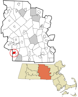
Holland is a census-designated place (CDP) in the town of Holland in Hampden County, Massachusetts, United States, comprising the town center and other populated areas in the eastern part of the town. The population was 1,464 at the 2010 census, out of a total 2,481 people in the town. It is part of the Springfield, Massachusetts Metropolitan Statistical Area.

<span class="mw-page-title-main">Duxbury (CDP), Massachusetts</span> Census-designated place in Massachusetts, United States

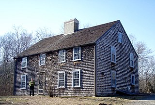
Duxbury is a census-designated place (CDP) in the town of Duxbury in Plymouth County, Massachusetts, United States. The population was 1,802 at the 2010 census.

<span class="mw-page-title-main">Marshfield (CDP), Massachusetts</span> Census-designated place in Massachusetts, United States

Marshfield is a census-designated place (CDP) in the town of Marshfield in Plymouth County, Massachusetts, United States. The population was 4,335 at the 2010 census.

<span class="mw-page-title-main">Athol (CDP), Massachusetts</span> CDP in Massachusetts, United States

Athol is a census-designated place (CDP) in the town of Athol in Worcester County, Massachusetts, United States. The population was 8,265 at the 2010 census.

<span class="mw-page-title-main">East Brookfield (CDP), Massachusetts</span> CDP in Massachusetts, United States

East Brookfield is a census-designated place (CDP) in the town of East Brookfield in Worcester County, Massachusetts, United States. The population was 1,323 at the 2010 census.

<span class="mw-page-title-main">Lunenburg (CDP), Massachusetts</span> CDP in Massachusetts, United States

Lunenburg is a census-designated place (CDP) in the town of Lunenburg in Worcester County, Massachusetts, United States. The population was 1,760 at the 2010 census.

<span class="mw-page-title-main">Milford (CDP), Massachusetts</span> CDP in Massachusetts, United States

Milford is a census-designated place (CDP) in the town of Milford in Worcester County, Massachusetts, United States. The population was 25,055 at the 2010 census.

<span class="mw-page-title-main">Oxford (CDP), Massachusetts</span> CDP in Massachusetts, United States

Oxford is a census-designated place (CDP) in the town of Oxford in Worcester County, Massachusetts, United States. The population was 6,103 at the 2010 census.

<span class="mw-page-title-main">Rutland (CDP), Massachusetts</span> CDP in Massachusetts, United States

Rutland is a census-designated place (CDP) in the town of Rutland in Worcester County, Massachusetts, United States. The population was 2,111 at the 2010 census.

<span class="mw-page-title-main">Sturbridge (CDP), Massachusetts</span> CDP in Massachusetts, United States

Sturbridge is a census-designated place (CDP) in the town of Sturbridge in Worcester County, Massachusetts, United States. The population was 2,253 at the 2010 census.

<span class="mw-page-title-main">Warren (CDP), Massachusetts</span> CDP in Massachusetts, United States

Warren is a census-designated place (CDP) in the town of Warren in Worcester County, Massachusetts, United States. The population was 1,405 at the 2010 census.

<span class="mw-page-title-main">Webster (CDP), Massachusetts</span> CDP in Massachusetts, United States

Webster is a census-designated place (CDP) in the town of Webster in Worcester County, Massachusetts, United States. The population was 11,412 at the 2010 census.

<span class="mw-page-title-main">Winchendon (CDP), Massachusetts</span> Census-designated place in Massachusetts, United States

Winchendon is a census-designated place (CDP) in the town of Winchendon in Worcester County, Massachusetts, United States. The population was 4,160 at the 2020 census.

References

  1. "2020 U.S. Gazetteer Files". United States Census Bureau. Retrieved May 21, 2022.
  2. CIS: Unincorporated and Unofficial Names of Massachusetts Communities
  3. "US Gazetteer files: 2010, 2000, and 1990". United States Census Bureau. February 12, 2011. Retrieved April 23, 2011.
  4. "Census of Population and Housing". Census.gov. Retrieved June 4, 2016.
  5. "U.S. Census website". United States Census Bureau . Retrieved January 31, 2008.