Northborough, Massachusetts

Last updated

Northborough, Massachusetts
First Parish Church, Northborough MA.jpg
First Parish Church
Flag of Northborough, Massachusetts.gif
Seal of Northborough, Massachusetts.png
Worcester County Massachusetts incorporated and unincorporated areas Northborough highlighted.svg
Location in Worcester County and the state of Massachusetts.
Coordinates: 42°19′10″N71°38′30″W / 42.31944°N 71.64167°W / 42.31944; -71.64167
CountryUnited States
State Massachusetts
County Worcester
Settled1672
Incorporated1766
Government
  Type Open town meeting
   Town
   Administrator
John W. Coderre
  Board of
   Selectmen
Mitch Cohen, Chair
Julianne Hirsh, Vice Chair
Kristen Wixted, Clerk
T. Scott Rogers
Jason Perreault
Area
  Total18.8 sq mi (48.6 km2)
  Land18.5 sq mi (48.0 km2)
  Water0.2 sq mi (0.6 km2)
Elevation
300 ft (91 m)
Population
 (2020)
  Total15,741
  Density840/sq mi (320/km2)
Demonym Northboroners
Time zone UTC−5 (Eastern)
  Summer (DST) UTC−4 (Eastern)
ZIP Code
01532
Area code 508 / 774
FIPS code 25-46820
GNIS feature ID0618375
Website town.northborough.ma.us

Northborough is a town in Worcester County, Massachusetts, United States. The official spelling of the town's name is "Northborough," but the alternative spelling "Northboro" is also used. The population was 15,741 at the 2020 census. [1]

Contents

History

The areas surrounding Northborough were first settled by the Nipmuc people. [2] Europeans set up a plantation on May 14, 1656, following a petition for resettlement from the people of the Sudbury Plantation to the General Court of the Bay Colony. [3] On January 24, 1766, the district of Northborough was established within neighboring Westborough. On August 23, 1775, the district became a town, and on June 20, 1807, part of neighboring Marlborough was annexed to Northborough. [4] [5]

The first meeting house was established in 1746, with the legal governor of the town being called the Town Minister. The first Town Minister was Reverend John Martyn.

In 1775, Northborough split off as the "north borough" of Westborough, much as Westborough had split from Marlborough some 58 years before. However, the two towns shared a meetinghouse for some time more.

Geography

According to the United States Census Bureau, the town has a total area of 18.8 square miles (49 km2), of which 18.5 square miles (48 km2) is land and 0.2 square miles (0.52 km2), or 1.17%, is water. On average, the town is about 302 feet (92 meters) above sea level.

Adjacent towns and cities

Northborough ma map.png

Northborough is located in Central Massachusetts, and shares a border with five towns and one city:

Of the six towns that make up Northborough's borders, and including Northborough as the seventh, Northborough is the fourth largest town by population. Marlborough is the largest while Berlin is the smallest.

Demographics

By the 2010 census, the population had reached 14155. By the 2020 census, the population was 15,741. [16]

As of the census of 2000, [17] there were 14,013 people, 4,906 households, and 3,865 families residing in the town. The population density was 756.1 inhabitants per square mile (291.9/km2). There were 5,002 housing units at an average density of 269.9 per square mile (104.2/km2). The racial makeup of the town was 93.01% White, 0.65% Black or African American, 0.08% Native American, 5.05% Asian, 0.07% Pacific Islander, 0.36% from other races, and 0.78% from two or more races. Hispanic or Latino of any race were 1.28% of the population.

There were 4,906 households, out of which 43.4% had children under the age of 18 living with them, 68.9% were married couples living together, 7.6% had a female householder with no husband present, and 21.2% were non-families. 17.1% of all households were made up of individuals, and 6.2% had someone living alone who was 65 years of age or older. The average household size was 2.83 and the average family size was 3.22.

In the town, the population was spread out, with 29.5% under the age of 18, 4.5% from 18 to 24, 31.3% from 25 to 44, 25.0% from 45 to 64, and 9.8% who were 65 years of age or older. The median age was 37 years. For every 100 females, there were 96.8 males. For every 100 females age 18 and over, there were 93.0 males.

The median income for a household in the town was $99,781, and the median income for a family was $120,480. Males had a median income of $65,437 versus $51,042 for females. The per capita income for the town was $42,889. About 1.7% of families and 2.8% of the population were below the poverty line, including 2.0% of those under age 18 and 9.3% of those age 65 or over.

Government

County-level state agency heads
Clerk of Courts:Dennis P. McManus (D)
District Attorney:Joe Early Jr. (D)
Register of Deeds:Katie Toomey (D)
Register of Probate:Stephanie Fattman (R)
County Sheriff: Lew Evangelidis (R)
State government
State Representative(s): Harold P. Naughton Jr. (D), Danielle Gregoire (D)
State Senator(s): Harriette L. Chandler (D-1st Worcester district), Jamie Eldridge (D)
Governor's Councilor(s):Jen Caissie (R), Marilyn M. Petitto Devaney (D)
Federal government
U.S. Representative(s): 2nd District
U.S. Senators: Elizabeth Warren (D), Ed Markey (D)

Library

Northborough public library, 1899 1899 Northborough public library Massachusetts.png
Northborough public library, 1899

The Northborough Free Library was established in 1868. [18] [19] In fiscal year 2009, the town of Northborough spent 1.5% ($645,208) of its budget on its public library—approximately $43.41 per person, per year ($53.36 adjusted for inflation to 2021). [20]

Education

Public schools

The Northborough-Southborough Public School District is home to four public elementary schools serving grades pre-kindergarten through grade 5. They include Lincoln Street School, Marguerite E. Peaslee School, Fannie E. Proctor School, and Marion E. Zeh school.

In 2002, the Northborough Middle School was renamed after former superintendent of schools, Robert E. Melican.

The public high school serving Northborough is Algonquin Regional High School, and is shared with Southborough. The mascot for Northborough-Southborough students was the Tomahawk, but was officially changed to the Titans in early 2022. Debates have erupted over whether Northborough and Southborough should have separate high schools; however, citizens of both Northborough and Southborough successfully fought to keep the school regionalized. Assabet Valley Regional Technical High School is an alternate choice for Northborough students.

Private schools

Private schools include The Cornerstone Academy, a private elementary school, and Saint Bernadette School, a private Roman Catholic elementary and middle school.

Sports

The New England Baseball Complex is located at the intersection of Route 20 and Route 9 in Northborough. The newly built complex is home to the New England Ruffnecks, a youth baseball association. Many high schools, including Algonquin have had MIAA games at the NEBC. Regional colleges and universities have hosted opponents at the New England Baseball Complex. Their little league of Algonquin shared with Southborough is open to any children. The local middle school, Robert E. Melican Middle School, has sports teams for 7th graders and up.

Notable people

Media

Newspapers

Related Research Articles

<span class="mw-page-title-main">Worcester County, Massachusetts</span> County in Massachusetts, United States

Worcester County is a county in the U.S. state of Massachusetts. At the 2020 census, the population was 862,111, making it the second-most populous county in Massachusetts. It is also the largest county in Massachusetts by geographic area. The largest city and traditional shire town is Worcester. Worcester County is part of the Worcester, MA–CT metropolitan statistical area and as the Boston–Worcester–Providence, MA–RI–NH–CT combined statistical area.

<span class="mw-page-title-main">Monterey, Massachusetts</span> Town in Massachusetts, United States

Monterey is a small town in Berkshire County, Massachusetts, United States. It is part of the Pittsfield, Massachusetts Metropolitan Statistical Area. The population was 1,095 at the 2020 census.

<span class="mw-page-title-main">New Marlborough, Massachusetts</span> Town in Massachusetts, United States

New Marlborough is a town in Berkshire County, Massachusetts, United States. It is part of the Pittsfield, Massachusetts Metropolitan Statistical Area. The population was 1,528 at the 2020 census. New Marlborough consists of five villages: Clayton, Hartsville, Mill River, New Marlborough Village and Southfield.

<span class="mw-page-title-main">Marlborough, Massachusetts</span> City in Massachusetts, United States

Marlborough is a city in Middlesex County, Massachusetts, United States. The population was 41,793 at the 2020 census. Marlborough became a prosperous industrial town in the 19th century and made the transition to high technology industry in the late 20th century after the construction of the Massachusetts Turnpike.

<span class="mw-page-title-main">Berlin, Massachusetts</span> Town in Massachusetts, United States

Berlin is a town in Worcester County, Massachusetts, United States. The town was first settled in 1665 and incorporated in 1812, and is governed under the open town meeting system. It is located 12 miles (19 km) northeast of Worcester and 29 miles (47 km) west of Boston. The population was 3,158 at the 2020 census.

<span class="mw-page-title-main">Boylston, Massachusetts</span> Town in Massachusetts, United States

Boylston is a town in Worcester County, Massachusetts, United States. The population was 4,849 at the 2020 census.

<span class="mw-page-title-main">Dudley, Massachusetts</span> Town in Massachusetts, United States

Dudley is a town in Worcester County, Massachusetts, United States. The population was 11,921 at the 2020 census.

<span class="mw-page-title-main">Northbridge, Massachusetts</span> Town in Massachusetts, United States

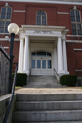
Northbridge is a town in Worcester County, Massachusetts, United States. The population was 16,335 at the 2020 census. The Northbridge Town Hall is located at 7 Main Street in Whitinsville. The town is now a part of the Blackstone River Valley National Heritage Corridor, of the National Park Service. Northbridge claims to history include: Native American Nipmuc lands, Colonel John Spring, who led the Uxbridge militia training company in the American Revolution, Samuel Spring, Revolutionary War Chaplain, the Residence of Ezra T. Benson 1830–1832, the birthplace of President Millard Fillmore's mother, Phoebe, and home to the Whitin Machine Works from 1831 to 1964.

<span class="mw-page-title-main">Petersham, Massachusetts</span> Town in Massachusetts, United States

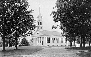
Petersham is a town in Worcester County, Massachusetts, United States. The population was 1,194 at the 2020 census. Petersham is home to a considerable amount of conservation land, including the Quabbin Reservation, Harvard Forest, the Swift River Reservation, and Federated Women's Club State Forest.

<span class="mw-page-title-main">Royalston, Massachusetts</span> Town in Massachusetts, United States

Royalston is a town in Worcester County, Massachusetts, United States. The population was 1,250 at the 2020 census.

<span class="mw-page-title-main">Shrewsbury, Massachusetts</span> Town in Massachusetts, United States

Shrewsbury is a town in Worcester County, Massachusetts, United States. The population was 38,325 according to the 2020 United States Census, in nearly 15,000 households.

<span class="mw-page-title-main">Southborough, Massachusetts</span> Town in Massachusetts, United States

Southborough is a town in Worcester County, Massachusetts, United States. It incorporates the villages of Cordaville, Fayville, and Southville. Its name is often informally shortened to Southboro, a usage seen on many area signs and maps, though officially rejected by town ordinance. At the 2020 census, its population was 10,450 in 3,542 households.

<span class="mw-page-title-main">Barre, Massachusetts</span> Town in Massachusetts, United States

Barre is a town in Worcester County, Massachusetts, United States. The population was 5,530 at the 2020 census.

<span class="mw-page-title-main">Sturbridge, Massachusetts</span> Town in Massachusetts, United States

Sturbridge is a town in Worcester County, Massachusetts, United States. It is home to Old Sturbridge Village living history museum and other sites of historical interest such as Tantiusques.

<span class="mw-page-title-main">Hopkinton, Massachusetts</span> Town in Massachusetts, United States

Hopkinton is a town in Middlesex County, Massachusetts, United States, 25 miles (40 km) west of Boston. The town is best known as the starting point of the Boston Marathon, held annually on Patriots' Day each April, and as the headquarters for the Dell EMC corporation.

<span class="mw-page-title-main">Algonquin Regional High School</span> Public secondary school in Northborough, Massachusetts, United States

<span class="mw-page-title-main">Boston and Worcester Street Railway</span>

Boston and Worcester Electric Companies (B&W) was a holding company for several streetcar companies between Boston and Worcester, Massachusetts. The main line, built by the Boston and Worcester Street Railway, was an interurban streetcar line partly on the old Boston and Worcester Turnpike and partly on private right-of-way. Long after the line was converted to buses, Boston and Worcester Lines took over operations, and sold the franchises to various other bus companies.

<span class="mw-page-title-main">Hudson, Massachusetts</span> Town in Massachusetts, United States

Hudson is a town in Middlesex County, Massachusetts, United States, with a total population of 20,092 as of the 2020 census. Before its incorporation as a town in 1866, Hudson was a neighborhood and unincorporated village of Marlborough, Massachusetts, and was known as Feltonville. From around 1850 until the last shoe factory burned down in 1968, Hudson was a mill town specializing in the production of shoes and related products. At one point the town had 17 shoe factories, many of them powered by the Assabet River, which runs through town. The many factories in Hudson attracted immigrants from Canada and Europe. Today most residents are of either Portuguese or Irish descent, with a smaller percentage being of French, Italian, English, or Scotch-Irish descent. While some manufacturing remains in Hudson, the town is now primarily residential. Hudson is served by the Hudson Public Schools district.

<span class="mw-page-title-main">Westborough, Massachusetts</span> Town in Worcester County, Massachusetts, US

Westborough is a town in Worcester County, Massachusetts, United States. The population was 21,567 at the 2020 Census, in over 7,000 households. Incorporated in 1717, the town is governed under the New England open town meeting system, headed by a five-member elected Board of Selectmen whose duties include licensing, appointing various administrative positions, and calling a town meeting of citizens annually or whenever the need arises.

<span class="mw-page-title-main">Massachusetts Senate's Middlesex and Worcester district</span> American legislative district

Massachusetts Senate's Middlesex and Worcester district in the United States is one of 40 legislative districts of the Massachusetts Senate. It covers 8.8% of Middlesex County and 4.8% of Worcester County population in 2010. Democrat Jamie Eldridge of Acton has represented the district since 2009.

References

  1. "Census - Geography Profile: Northborough town, Worcester County, Massachusetts". United States Census Bureau . Retrieved November 11, 2021.
  2. "NIAC Publications ~ Nipmuc Place Names – Territory and Language". nativetech.org.
  3. Josiah Coleman Kent (1921). Northborough History. Garden City Press, Incorporated, printers.
  4. Record Commission, Massachusetts (1889). "First- Thirty Second Report of the Commissioner of Public Records ..." google.com.
  5. The annexation was requested by Jonas Bartlett, whose property straddled the border between the two towns. The minutes of town meetings for both towns record the change, which redrew the boundary to conform to Bartlett's property line.
  6. "TOTAL POPULATION (P1), 2010 Census Summary File 1, All County Subdivisions within Massachusetts". United States Census Bureau. Archived from the original on February 12, 2020. Retrieved September 13, 2011.
  7. "Massachusetts by Place and County Subdivision – GCT-T1. Population Estimates". United States Census Bureau. Archived from the original on February 12, 2020. Retrieved July 12, 2011.
  8. "1990 Census of Population, General Population Characteristics: Massachusetts" (PDF). US Census Bureau. December 1990. Table 76: General Characteristics of Persons, Households, and Families: 1990. 1990 CP-1-23. Archived from the original (PDF) on December 7, 2013. Retrieved July 12, 2011.
  9. "1980 Census of the Population, Number of Inhabitants: Massachusetts" (PDF). US Census Bureau. December 1981. Table 4. Populations of County Subdivisions: 1960 to 1980. PC80-1-A23. Retrieved July 12, 2011.
  10. "1950 Census of Population" (PDF). 1: Number of Inhabitants. Bureau of the Census. 1952. Section 6, Pages 21–10 and 21-11, Massachusetts Table 6. Population of Counties by Minor Civil Divisions: 1930 to 1950. Retrieved July 12, 2011.{{cite journal}}: Cite journal requires |journal= (help)
  11. "1920 Census of Population" (PDF). Bureau of the Census. Number of Inhabitants, by Counties and Minor Civil Divisions. Pages 21–5 through 21-7. Massachusetts Table 2. Population of Counties by Minor Civil Divisions: 1900, 1910, and 1920. Retrieved July 12, 2011.
  12. "1890 Census of the Population" (PDF). Department of the Interior, Census Office. Pages 179 through 182. Massachusetts Table 5. Population of States and Territories by Minor Civil Divisions: 1880 and 1890. Retrieved July 12, 2011.
  13. "1870 Census of the Population" (PDF). Department of the Interior, Census Office. 1872. Pages 217 through 220. Table IX. Population of Minor Civil Divisions, &c. Massachusetts. Retrieved July 12, 2011.
  14. "1860 Census" (PDF). Department of the Interior, Census Office. 1864. Pages 220 through 226. State of Massachusetts Table No. 3. Populations of Cities, Towns, &c. Retrieved July 12, 2011.
  15. "City and Town Population Totals: 2020-2022". United States Census Bureau . Retrieved November 23, 2023.
  16. "U.S Census Buereau Quickfacts: Northborough town, Worcester County, Massachusetts; United States" . Retrieved August 13, 2021.
  17. "U.S. Census website". United States Census Bureau . Retrieved January 31, 2008.
  18. C.B. Tillinghast. The free public libraries of Massachusetts. 1st Report of the Free Public Library Commission of Massachusetts. Boston: Wright & Potter, 1891. Google books
  19. "Untitled Document". northboroughlibrary.org. Archived from the original on December 17, 2010. Retrieved November 10, 2010.
  20. July 1, 2008 through June 30, 2009; cf. The FY2009 Municipal Pie: What’s Your Share? Commonwealth of Massachusetts, Board of Library Commissioners. Boston: 2010. Available: Municipal Pie Reports Archived January 23, 2012, at the Wayback Machine . Retrieved 2011-11-11
  21. 1 2 Who Was Who in America, Historical Volume, 1607–1896. Marquis Who's Who. 1967.
  22. "Northboro Chorus revels in 'Blowing Bubbles'".
  23. Rick Rendell/Daily News staff. "London calling for Northborough's McMenemy". MetroWest Daily News, Framingham, MA.
  24. "Dr. Pincus, Developer of Birth-Control Pill, Dies". The New York Times . August 23, 1967. Retrieved July 21, 2007. Dr. Gregory Goodwin Pincus, one of the three "fathers" of the birth-control pill, died here tonight at Peter Bent Brigham Hospital of myeloid metaplasia, a rare blood disease. He was 64 years old and lived in Northboro.
  25. "Home – telegram.com – Worcester, MA". telegram.com.
  26. "Town of Northborough in Massachusetts". communityadvocate.com. Archived from the original on October 21, 2017. Retrieved August 22, 2013.
  27. "Home – The Villager – Northborough, MA". The Villager.
  28. "Northborough, MA Patch – Local News, Community, Sports, Shopping, Restaurants, Things To Do". Northborough, Massachusetts Patch.