Medway, Massachusetts

Last updated

Medway, Massachusetts
Sanford Mills, Medway MA.jpg
Sanford Mills on the Charles River
MedwaySeal-MA.png
Norfolk County Massachusetts incorporated and unincorporated areas Medway highlighted.svg
Location in Norfolk County in Massachusetts
Coordinates: 42°08′30″N71°23′50″W / 42.14167°N 71.39722°W / 42.14167; -71.39722
Country Flag of the United States.svg United States
State Flag of Massachusetts.svg  Massachusetts
County Flag of Norfolk County, Massachusetts.gif Norfolk
Settled1657
Incorporated1713
FounderHenry Garnsey
Medway 300January 1, 2013
Government
  Type Open town meeting
Area
  Total29.9 km2 (11.5 sq mi)
  Land29.7 km2 (11.5 sq mi)
  Water0.2 km2 (0.1 sq mi)
Elevation
61 m (200 ft)
Population
 (2020)
  Total13,115
  Density441.6/km2 (1,140.4/sq mi)
Demonym Medwanian
Time zone UTC−5 (Eastern)
  Summer (DST) UTC−4 (Eastern)
ZIP Code
02053
Area code 508/774
FIPS code 25-39975
GNIS feature ID0619458
Website Town of Medway, Massachusetts

Medway is a town in Norfolk County, Massachusetts, United States. The town had a population of 13,115 at the 2020 census. [1]

Contents

History

Medway (originally Midway)[ citation needed ] was first settled in 1657 and was officially incorporated in 1713. [2] At that time, Medway began as a farming community of two hundred thirty-three. It was not long before the water power of the Charles River and Chicken Brook stimulated the formation of cotton and paper mills, straw and boot factories, and a variety of cottage industries. Medway demonstrates the central importance of the Charles River and the thriving town that grew alongside it. Today, the one-room schoolhouses are gone and the country stores have moved to the mall, but the open town meetings continue.

After nearby Medfield was established as a town in 1651, an increasing number of newcomers settled on the land west of the Charles River. By 1712, this settlement west of the Charles had grown large enough to petition the Massachusetts General Court for the creation of a separate new town. That petition was granted, and the town of Medway incorporated on October 25, 1713. At its founding by Henry Garnsey, and for 170 years afterward, the town of Medway included the land that is now Millis. Eventually, the eastern section of the town, known as East Medway, separated in 1885 to form the town of Millis, and Medway assumed the shape it has today.

The main cause for the independent formation of Millis from Medway was the physical separation caused by a massive tract of undevelopable land appropriately named in those times, the Great Black Swamp. The Black Swamp was at the geographical center point of Medway and East Medway. Had the land been developable, this would have been the ideal location for a central meeting house, as well as churches and schools. However, because the thick forest/swamp was completely undevelopable, this forced inhabitants of Medway and East Medway to form separate communities with their own respective necessities such as a meeting house and churches. Despite this natural separation, the town remained as one for over 170 years.

The oldest road in Medway was laid out in 1670 and was known for years as Old Mendon Road. Since that time, this road has been known by many names including The Road to the Wilderness, The Old County Road, The Middle Post Road, and most recently, Village Street. Village Street runs from the Millis border on the east and meanders along the Charles River before eventually joining Main Street just before the Bellingham border on the west. The heart of the old town of Medway is found along this road, with the central location of activity at Medway Village, where Holliston Street intersects with Village Street.

In 1869, all of the streets in Medway were officially named. Many streets ended up losing their original names, and were instead named after influential townspeople of the past and present. Some examples of this were; Pine Hill Road became Winthrop Street, Vine Lane became Kelley Street, Candlewood Island Road was named Oakland Street, and The Old Hartford Turnpike was named Main Street. A few other examples of roads in Medway named after past residents include Lovering Street, Adams Street, Partridge Street, Ellis Street, Clark Street, Coffee Street, and Barber Street.

Geography

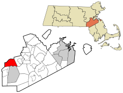
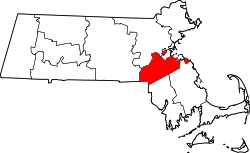
According to the United States Census Bureau, the town has a total area of 11.5 square miles (30 km2), of which 11.4 square miles (30 km2) is land and 0.1 square miles (0.26 km2) (0.78%) is water. Medway is the geographical center between Boston, Worcester, and Providence, which is purported by some to explain the origin of the name. However, like many New England cities and towns, it most likely derived its name from an English location, in this case, the region of Medway, England, or the River Medway.

Demographics

Historical population
YearPop.±%
1850 2,778    
1860 3,195+15.0%
1870 3,721+16.5%
1880 3,956+6.3%
1890 2,985−24.5%
1900 2,761−7.5%
1910 2,696−2.4%
1920 2,956+9.6%
1930 3,153+6.7%
1940 3,297+4.6%
1950 3,744+13.6%
1960 5,168+38.0%
1970 7,938+53.6%
1980 8,447+6.4%
1990 9,931+17.6%
2000 12,448+25.3%
2010 12,752+2.4%
2020 13,115+2.8%
202213,393+2.1%
* = population estimate.
Source: United States census records and Population Estimates Program data. [3] [4] [5] [6] [7] [8] [9] [10] [11] [12] [13]

As of the census [14] of 2000, there were 12,448 people, 4,182 households, and 3,337 families residing in the town. The population density was 1,087.0 inhabitants per square mile (419.7/km2). There were 4,248 housing units at an average density of 371.0 per square mile (143.2/km2). The racial makeup of the town was 97.5% White, 0.57% African American 0.10% Native American, 0.96% Asian, 0.02% Pacific Islander, 0.16% from other races, and 0.67% from two or more races. Hispanic or Latino of any race were 0.84% of the population. [15]

There were 4,182 households, out of which 97.7% had children under the age of 18 living with them, 69% were married couples living together, 7.5% had a female householder with no husband present, and 20.2% were non-families. 17.2% of all households were made up of individuals, and 7.1% had someone living alone who was 65 years of age or older. The average household size was 2.95 and the average family size was 3.36.

In the town, the population was spread out, with 31.9% under the age of 18, 4.3% from 18 to 24, 33.4% from 25 to 44, 21.4% from 45 to 64, and 9.1% who were 65 years of age or older. The median age was 36 years. For every 100 females, there were 94.0 males. For every 100 females age 18 and over, there were 90.3 males.

The median income for a household in the town was $150,673 and the median income for a family was $172,302. Males had a median income of $121,245 versus $86,149 for females. The per capita income for the town was $51,008. About 1.8% of families and 5.2% of the population were below the poverty line, including 1.6% of those under age 18 and 4.6% of those age 65 or over.

Sports

Football

In 2006, the New England Intensity of the Independent Women's Football League began playing its home games at Medway's Hanlon Field.

In 2008, the Bay State Renegades, of the New England Football League, began playing their home games at Hanlon Field. The team won four of the five games played at their new home. In 2007, the Worcester Wildcats, also of the NEFL, relocated for one season to Hanlon Field as their home in Worcester underwent significant renovations.

Education

Medway Public Schools are part of the Medway Public Schools school district. [16] Currently, there are four schools actively enrolling students in the district. The McGovern school provides preschool, kindergarten, and 1st-grade education, the Burke-Memorial school provides 2nd–4th grade education, Medway Middle School provides 5th–8th-grade education, and Medway High School. The High School is the newest of the four schools. The building was completed in 2003 and the school saw its first graduating class in 2005. As of 2004, the high school had 771 students and 52 teachers, with a teacher:student ratio of 1:15. The Middle School was completely renovated and modernized in 2012.

In 2008, approximately 217 10th grade students participated in the Massachusetts Comprehensive Assessment System exam. The passing rate was 96.3% for both the Math and English Language sections, and 87.9% for the Science section. In 2007, 193 Medway High School students took the SAT, an increase from previous years. The average composite score was 1,614; of these students, 85.8% chose to attend a four-year college education program.

Transportation

Both Route 109 and Route 126 pass through the town and serve as some of the main roads in the town. Interstate 495 shortly passes through the southwest corner of the town, but does not provide any exits. The closest exits are in nearby Bellingham and Milford.

The closest MBTA Commuter Rail service is at Forge Park/495, Franklin/Dean College, and Norfolk stations on the Franklin/Foxboro Line. Until 1966, the Millis Branch served stations at Medway and West Medway.

Places of worship

Medway is home to four churches:

Notable people

Related Research Articles

<span class="mw-page-title-main">Lanesborough, Massachusetts</span> Town in Massachusetts, United States

Lanesborough is a town in Berkshire County, Massachusetts, United States. It is part of the Pittsfield, Massachusetts Metropolitan Statistical Area. The population was 3,038 at the 2020 census.

<span class="mw-page-title-main">Berkley, Massachusetts</span> Town in Massachusetts, United States

Berkley is a town in Bristol County, Massachusetts, United States, located south of Boston and east of Providence, Rhode Island. The population was 6,764 according to the 2020 census, making it the least populated town in the county.

<span class="mw-page-title-main">Groveland, Massachusetts</span> Town in Massachusetts, United States

Groveland is a town in Essex County, Massachusetts, United States. It is thirty-four miles north of Boston. At the 2020 census, it had a population of 6,752. The town is divided into two precincts, Groveland and South Groveland.

<span class="mw-page-title-main">Gill, Massachusetts</span> Town in Massachusetts, United States

Gill is a town in Franklin County, Massachusetts, United States. The population was 1,551 at the 2020 census. It is part of the Springfield, Massachusetts Metropolitan Statistical Area. The campus of Northfield Mount Hermon School is located in the Mount Hermon section of the town.

<span class="mw-page-title-main">Leverett, Massachusetts</span> Town in Massachusetts, United States

Leverett is a town in Franklin County, Massachusetts, United States. The population was 1,865 as of the 2020 census. It is part of the Springfield, Massachusetts Metropolitan Statistical Area.

<span class="mw-page-title-main">East Longmeadow, Massachusetts</span> City in Massachusetts, United States

East Longmeadow is a town in Hampden County, Massachusetts, United States, situated in the Pioneer Valley region of Western Massachusetts. It had a population of 16,430 at the 2020 census. East Longmeadow is 5 mi (8.0 km) southeast of downtown Springfield, part of the Springfield Metropolitan Statistical Area. Additionally, the town is 25 mi (40 km) north of Hartford, 88 mi (142 km) southwest of Boston, and 142 mi (229 km) northeast of New York City.

<span class="mw-page-title-main">Cummington, Massachusetts</span> Town in Massachusetts, United States

Cummington is a town in Hampshire County, Massachusetts, United States. The population was 829 at the 2020 census, a decline from the figure of 872 tabulated in 2010. It is part of the Springfield, Massachusetts Metropolitan Statistical Area.

<span class="mw-page-title-main">Huntington, Massachusetts</span> Town in Massachusetts, United States

Huntington is a town in Hampshire County, Massachusetts, United States. The population was 2,094 at the 2020 census. It is part of the Springfield, Massachusetts Metropolitan Statistical Area.

<span class="mw-page-title-main">Dunstable, Massachusetts</span> Town in Massachusetts, United States

Dunstable is a town in Middlesex County, Massachusetts, United States. The population was 3,358 at the 2020 census.

<span class="mw-page-title-main">Sherborn, Massachusetts</span> Town in Massachusetts, United States

Sherborn is a town in Middlesex County, Massachusetts, United States. Located in Boston's MetroWest region, the community is within area code 508 and has the ZIP code 01770. As of the 2020 U.S. Census, the town population was 4,401.

<span class="mw-page-title-main">Millis, Massachusetts</span> Town in Massachusetts, United States

Millis is a town in Norfolk County in the U.S. state of Massachusetts. It had a population of 8,460 at the 2020 census. The town is approximately 19 miles (31 km) southwest of downtown Boston and is bordered by Norfolk, Sherborn, Holliston, Medfield, and Medway. Massachusetts state routes 109 and 115 run through Millis.

<span class="mw-page-title-main">Hardwick, Massachusetts</span> Town in Massachusetts, United States

Hardwick is a town in Worcester County, Massachusetts, United States, about 20 miles (32 km) northwest of the city of Worcester. It had a population of 2,667 at the 2020 census. It includes the villages of Hardwick, Gilbertville, Wheelwright and Old Furnace.

<span class="mw-page-title-main">Royalston, Massachusetts</span> Town in Massachusetts, United States

Royalston is a town in Worcester County, Massachusetts, United States. The population was 1,250 at the 2020 census.

<span class="mw-page-title-main">Sutton, Massachusetts</span> Town in Massachusetts, United States

Sutton, officially the Town of Sutton, is a town in Worcester County, Massachusetts, United States. The population was 9,357 in the 2020 United States Census. Located in the Blackstone Valley, the town was designated as a Preserve America community in 2004.

<span class="mw-page-title-main">Medfield, Massachusetts</span> Town in Massachusetts, United States

Medfield is a town in Norfolk County, Massachusetts, United States. The population was 12,799 according to the 2020 United States Census. It is a community about 17 miles (27 km) southwest of Boston, Massachusetts, which is a 40-minute drive to Boston's financial district. Attractions include the Hinkley Pond and the Peak House.

<span class="mw-page-title-main">East Brookfield, Massachusetts</span> Town in Massachusetts, United States

East Brookfield is a town in Worcester County, Massachusetts, United States. The population was 2,224 at the 2020 United States Census. The census-designated place of East Brookfield (CDP) is located in the town. The village of Union Chapel is also located in the town.

<span class="mw-page-title-main">Oxford, Massachusetts</span> Town in Massachusetts, United States

Oxford is a town in Worcester County, Massachusetts, United States. The population was 13,347 as of the 2020 United States Census.

<span class="mw-page-title-main">Sturbridge, Massachusetts</span> Town in Massachusetts, United States

Sturbridge is a town in Worcester County, Massachusetts, United States. It is home to Old Sturbridge Village living history museum and other sites of historical interest such as Tantiusques.

<span class="mw-page-title-main">Bellingham, Massachusetts</span> Town in Massachusetts, United States

Bellingham is a town in Norfolk County, Massachusetts, United States. The population was 16,945 at the 2020 census. The town sits on the southwestern fringe of Metropolitan Boston, along the rapidly growing "outer belt" that is Interstate 495. It is formally a part of the Boston–Cambridge–Quincy metropolitan statistical area, as well as the Providence metropolitan area.

<span class="mw-page-title-main">Southbridge, Massachusetts</span> Town in Massachusetts, United States

Southbridge is a city in Worcester County, Massachusetts, United States. The population was 17,740 at the 2020 census. Although Southbridge has a city form of government, it is legally known as the Town of Southbridge.

References

  1. "Census - Geography Profile: Medway town, Norfolk County, Massachusetts" . Retrieved November 6, 2021.
  2. "Town of Medway, Massachusetts". Town of Medway, Massachusetts. Archived from the original on August 28, 2012. Retrieved August 25, 2012.
  3. "Total Population (P1), 2010 Census Summary File 1". American FactFinder, All County Subdivisions within Massachusetts. United States Census Bureau. 2010.
  4. "Massachusetts by Place and County Subdivision - GCT-T1. Population Estimates". United States Census Bureau. Retrieved July 12, 2011.
  5. "1990 Census of Population, General Population Characteristics: Massachusetts" (PDF). US Census Bureau. December 1990. Table 76: General Characteristics of Persons, Households, and Families: 1990. 1990 CP-1-23. Retrieved July 12, 2011.
  6. "1980 Census of the Population, Number of Inhabitants: Massachusetts" (PDF). US Census Bureau. December 1981. Table 4. Populations of County Subdivisions: 1960 to 1980. PC80-1-A23. Retrieved July 12, 2011.
  7. "1950 Census of Population" (PDF). Bureau of the Census. 1952. Section 6, Pages 21-10 and 21-11, Massachusetts Table 6. Population of Counties by Minor Civil Divisions: 1930 to 1950. Retrieved July 12, 2011.
  8. "1920 Census of Population" (PDF). Bureau of the Census. Number of Inhabitants, by Counties and Minor Civil Divisions. Pages 21-5 through 21-7. Massachusetts Table 2. Population of Counties by Minor Civil Divisions: 1920, 1910, and 1920. Retrieved July 12, 2011.
  9. "1890 Census of the Population" (PDF). Department of the Interior, Census Office. Pages 179 through 182. Massachusetts Table 5. Population of States and Territories by Minor Civil Divisions: 1880 and 1890. Retrieved July 12, 2011.
  10. "1870 Census of the Population" (PDF). Department of the Interior, Census Office. 1872. Pages 217 through 220. Table IX. Population of Minor Civil Divisions, &c. Massachusetts. Retrieved July 12, 2011.
  11. "1860 Census" (PDF). Department of the Interior, Census Office. 1864. Pages 220 through 226. State of Massachusetts Table No. 3. Populations of Cities, Towns, &c. Retrieved July 12, 2011.
  12. "1850 Census" (PDF). Department of the Interior, Census Office. 1854. Pages 338 through 393. Populations of Cities, Towns, &c. Retrieved July 12, 2011.
  13. "City and Town Population Totals: 2020-2022". United States Census Bureau . Retrieved October 21, 2023.
  14. "U.S. Census website". United States Census Bureau . Retrieved January 31, 2008.
  15. US Census Factfinder Massachusetts by Place and County Subdivision GCT-PL. Race and Hispanic or Latino Archived February 12, 2020, at archive.today
  16. "Medway Public Schools". Medway Public Schools. Retrieved August 25, 2012.
  17. "William Taylor Adams".
  18. "The Pulitzer Prizes".