Medway is a town in Norfolk County, Massachusetts, United States with a population of about 13,000.

Uxbridge is a town in Worcester County, Massachusetts first colonized in 1662 and incorporated in 1727. It was originally part of the town of Mendon, and named for the Earl of Uxbridge. The town is located 36 mi (58 km) southwest of Boston and 15 mi (24 km) south-southeast of Worcester, at the midpoint of the Blackstone Valley National Historic Park. Uxbridge was a prominent Textile center in the American Industrial Revolution. Two local Quakers served as national leaders in the American anti-slavery movement. Uxbridge "weaves a tapestry of early America".

Cumberland is the northeasternmost town in Providence County, Rhode Island, United States, first settled in 1635 and incorporated in 1746. The population was 33,506 at the 2010 census.

Ware is a town in Hampshire County, Massachusetts, United States. The population was 9,872 at the 2010 census. It is part of the Springfield, Massachusetts Metropolitan Statistical Area.

New Hartford is a town in Oneida County, New York, United States. As of the 2010 census, the town population was 22,166. The name of New Hartford was provided by a settler family from Hartford, Connecticut.

The Phelps and Gorham Purchase was the purchase in 1788 of 6,000,000 acres (24,000 km2) of land in what is now western New York State from the Commonwealth of Massachusetts for $1,000,000 (£300,000), to be paid in three annual installments, and the pre-emptive right to the title on the land from the Six Nations of the Iroquois Confederacy for $5000 (£12,500). A syndicate formed by Oliver Phelps and Nathaniel Gorham bought preemptive rights to 6,000,000-acre (24,000 km2) in New York, west of Seneca Lake between Lake Ontario and the Pennsylvania border, from the Commonwealth of Massachusetts.
Breakheart Reservation is a public recreation area covering 652 acres (264 ha) in the towns of Saugus and Wakefield, Massachusetts. The reservation features a hardwood forest, two freshwater lakes, a winding stretch of the Saugus River, and scenic views of Boston and rural New England from rocky hilltops. The park is managed by the Massachusetts Department of Conservation and Recreation.

The Holyoke Canal System is a system of power canals in Holyoke, Massachusetts. It is split into three canals based on elevation and distance from the inlet at the Holyoke Dam- the First Level Canal, Second Level Canal, and Third Level Canal. Constructed over a period between 1847 and 1892, the Canal System, along with the Dam, is recognized as a Historic Mechanical Engineering Landmark by the American Society of Mechanical Engineers for its use in the development of the Venturi meter by Clemens Herschel, the first means of measuring large-scale flows, and the McCormick-Holyoke Turbine by John B. McCormick, which doubled the efficiency of turbines to more than 80% in its time.
The history of Dedham, Massachusetts, from 1800 to 1999 saw tremendous growth and change come to the town. Having been named Dedham shiretown of the newly formed Norfolk County in 1793, the town got an influx of new residents and visitors. This growth was aided by new turnpikes and railroads. In the 19th century many former farms would become businesses and homes for those who commuted into Boston. The population of the town grew by more than 10 times, and included Horace Mann, Louis Brandeis, and Henry Bradford Endicott.
Milton Holbrook Sanford was an American businessman, lawyer, and owner/breeder of Thoroughbred racehorses.

Cove Lake State Park is a state park in Campbell County, Tennessee, in the southeastern United States. The park consists of 673 acres (2.72 km2) situated around Cove Lake, an impoundment of Cove Creek created by the completion of Caryville Dam in 1936. The park's location is adjacent to the town of Caryville and just west of Jacksboro.

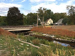
North Uxbridge is a village and a post office in the town (township) of Uxbridge in Worcester County, Massachusetts, United States. The postal zip code is 01538. It is classified as a community or populated place located at latitude 42.088 and longitude -71.641 and the elevation is 266 feet (81 m). North Uxbridge appears on the Uxbridge U.S. Geological Survey Map. Worcester County is in the Eastern time zone and observes DST. North Uxbridge is located about 36 miles WSW of Boston, and 15 miles SE of Worcester. The town meeting in 1885 set aside North Uxbridge as a "special district", since its population had exceeded 1000 people. North Uxbridge appeared to be a separate Census tract in the 1960 census with a population of 1882. In 2013, an Uxbridge DIY show, The Garage, with Steve Butler, went worldwide from Steve's garage in North Uxbridge.
Newry is a census-designated place in Oconee County, South Carolina, United States. According to the 2010 United States Census, the population of the CDP was 172.
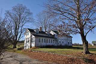
The Metcalf–Franklin Farm is an historic farm that has been in operation since 1801 and is located at 142 Abbott Run Valley Road in Cumberland, Rhode Island. It has been farmed by two family owners, the Metcalf family (1801-1857) and the Franklin family. It consists of a small complex of farm buildings on two parcels of land, located on either side of Abbott Run Valley Road and totaling over 65.35 acres (26.45 ha)

Bellingham is a town in Norfolk County, Massachusetts, United States. The population was 16,332 at the 2010 census. The town sits on the southwestern fringe of Metropolitan Boston, along the rapidly growing "outer belt" that is Route 495. It is formally a part of the Boston–Cambridge–Quincy metropolitan statistical area, as well as the Providence metropolitan area.
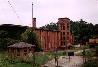
The Stillwater Mill was a former textile factory located in Smithfield, Rhode Island.

Conestee Mill is a historic mill in the unincorporated community of Conestee, in Greenville County, South Carolina.
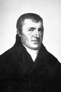
Jedediah Sanger was the founder of the town of New Hartford, New York, United States. He was a native of Sherborn, Massachusetts, and the ninth child of Richard and Deborah Sanger, a prominent colonial New England family. During the Revolutionary War he attained the rank of 1st Lieutenant having fought in the Battles of Lexington and Concord, the Battle of Bunker Hill, the Siege of Boston (1776), and during the New York Campaign.
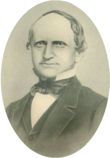
George Clinton Ewing was a salesman, wainwright, land agent, superintendent, assessor, selectman, state representative, and most notably one of the chief founders of Holyoke, Massachusetts; he is credited as having first brought the idea of building a dam and industrial city at Hadley Falls to investors in Boston, New York, Hartford, and St. Johnsbury, Vermont in 1846.
The history of Dedham, Massachusetts from 1700 to 1799 saw the town become one of the largest and most influential country towns in Massachusetts. As the population grew and residents moved to outlying areas of the town, battles for political power took place. Similar battles were taking place within the churches, as liberal and conservative factions bristled at paying for ministers with whom they had differences of theological opinion. New parishes and preciencts were formed, and eventually several new towns broke away.