Amherst, New Hampshire

Last updated

Amherst, New Hampshire
Town
Amherst NH Common, 2006.JPG
Amherst Town Common in 2006
Amherst Town Seal.png
Hillsborough-Amherst-NH.png
USA New Hampshire location map.svg
Red pog.svg
Amherst
Usa edcp location map.svg
Red pog.svg
Amherst
Coordinates: 42°51′41″N71°37′31″W / 42.86139°N 71.62528°W / 42.86139; -71.62528
CountryUnited States
State New Hampshire
County Hillsborough
Incorporated 1760
Government
   Board of Selectmen
  • Peter Lyon, Chair
  • Tom Grella
  • Danielle Pray
  • John D'Angelo
  • William Stoughton
  Town AdministratorDean Shankle
Area
[1]
  Total34.4 sq mi (89.1 km2)
  Land33.9 sq mi (87.8 km2)
  Water0.5 sq mi (1.3 km2)  1.49%
Elevation
259 ft (79 m)
Population
 (2020) [2]
  Total11,753
  Density347/sq mi (133.8/km2)
Time zone UTC−5 (Eastern)
  Summer (DST) UTC−4 (Eastern)
ZIP code
03031
Area code 603
FIPS code 33-01300
GNIS feature ID0873531
Website www.amherstnh.gov

Amherst is a town in Hillsborough County in the state of New Hampshire, United States. The population was 11,753 at the 2020 census. [2] Amherst is home to Ponemah Bog Wildlife Sanctuary, Hodgman State Forest, the Joe English Reservation and Baboosic Lake.

Contents

The village of Amherst, where 697 people lived at the 2020 census, is defined as the Amherst census-designated place and is listed on the National Register of Historic Places as Amherst Village Historic District.

History

A photograph of Amherst taken in 1910 Post Office Square, Amherst Plains, NH.jpg
A photograph of Amherst taken in 1910

Like many towns in New England, Amherst was founded via a land grant issued to members of the colonial militia; the land grant which led to the town's foundation was issued in 1728 to veterans of King Philip's War. A colonial settlement was established at the land grant's location five years later in 1733, being initially named "Narragansett Number 3" and later "Souhegan Number 3". In 1741, the settlement's inhabitants established a Congregational church and hired a minister to preach in the settlement. On January 18, 1760, the settlement was chartered by the governor of New Hampshire Benning Wentworth, who renamed it after General Jeffery Amherst, who served as Commander-in-Chief, North America during the French and Indian War. [3] [4] Wentworth chartered Amherst as part of a wave of land grants he issued during the mid-18th century. [5]

In 1770, Amherst became the county seat of Hillsborough County, due largely to its location on the county's major east-west road. It continued to prosper through the Revolutionary War and afterwards. In 1790, the southwestern section broke off and became the town of Milford, and in 1803, the northwest section departed to become Mont Vernon. The development of water-powered mills allowed Milford to grow at Amherst's expense, and the county seat was moved to Milford in 1866.

The town population remained relatively stagnant until after World War II, when Amherst and many surrounding towns saw an influx of newcomers as the town became part of the Greater Boston region.

Franklin Pierce, who later become the 14th President of the United States studied under Judge Edmund Parker in Amherst. He wed Jane Means Appleton, the daughter of a former president of Bowdoin College, in a house on the town green.

The Nashua and Wilton Railroad passed through Amherst. [4]

Government and politics

Amherst town presidential vote [6]
Year Democratic Republican Third parties
2020 58.9% 4,79639.4% 3,2081.5% 133
2016 51.4% 3,77744.5% 3,2714.0% 299
2012 46.5% 3,50151.9%3,9061.6% 114
2008 51.4% 3,82247.6% 3,5361.0% 68

Amherst is located in New Hampshire's 2nd congressional district, represented by Democrat Ann McLane Kuster (D-Hopkinton). The town is located in New Hampshire's 11th State Senate district, represented by Democrat Shannon Chandley (D-Amherst).

In the New Hampshire House of Representatives, Amherst has two districts covering the town. Hillsborough 34 is a district with three seats covering just the town of Amherst; it is currently represented by three Democrats: Dan Leclerc, Jennifer Morton, and Dan Veilleux. Amherst also shares Hillsborough 37, a single-member district, with the neighboring town of Milford, New Hampshire; it is represented by Democrat Megan Murray (D-Amherst). [7]

Geography

According to the United States Census Bureau, the town has a total area of 34.4 square miles (89.1 km2), of which 33.9 square miles (87.8 km2) are land and 0.50 square miles (1.3 km2), or 1.49% of the total area, are water. [1] The entire town is part of the Merrimack River watershed. [8] The Souhegan River, an east-flowing tributary of the Merrimack, passes through the southern part of the town, and the Souhegan's tributary Beaver Brook drains the central part of town and passes through the main village. Baboosic Lake is farther north, along the eastern border of the town and is fed by Joe English Brook. The lake drains to the east into Baboosic Brook, a tributary of the Merrimack. Pulpit Brook, which drains the northeastern corner of the town, flows into Baboosic Brook as well. Witches Brook flows through the southernmost part of the town and is a tributary of Pennichuck Brook, yet another tributary of the Merrimack. Amherst's highest point is on Chestnut Hill at the town's northern border, where the elevation reaches 865 feet (264 m) above sea level.

New Hampshire Route 101 crosses the town, leading northeast into Bedford and then to Manchester, and southwest into Milford. A spur, New Hampshire Route 101A, crosses the southern part of Amherst, connecting Milford to the west with Nashua to the southeast. New Hampshire Route 122 begins at Amherst village and leads south into Hollis.

Adjacent municipalities

Demographics

Historical population
CensusPop.Note
1790 2,369
1800 1,470−37.9%
1810 1,5545.7%
1820 1,6224.4%
1830 1,6572.2%
1840 1,565−5.6%
1850 1,6133.1%
1860 1,598−0.9%
1870 1,353−15.3%
1880 1,225−9.5%
1890 1,053−14.0%
1900 1,23116.9%
1910 1,060−13.9%
1920 868−18.1%
1930 1,11528.5%
1940 1,1745.3%
1950 1,46124.4%
1960 2,05140.4%
1970 4,605124.5%
1980 8,24379.0%
1990 9,06810.0%
2000 10,76918.8%
2010 11,2014.0%
2020 11,7534.9%
U.S. Decennial Census [2] [9]
Greeley birthplace c. 1905 Horace Greeley Birthplace, Amherst, NH.jpg
Greeley birthplace c.1905

As of the census of 2010, there were 11,201 people, 4,063 households, and 3,322 families residing in the town. The population density was 327.5 inhabitants per square mile (126.4/km2). There were 4,280 housing units at an average density of 125.1 per square mile (48.3/km2). The racial makeup of the town was 95.8% White, 0.5% African American, 0.1% Native American, 1.7% Asian, 0.04% Pacific Islander, 0.4% some other race, and 1.5% from two or more races. Hispanic or Latino of any race were 1.9% of the population. [10]

There were 4,063 households, out of which 37.7% had children under the age of 18 living with them, 72.2% were headed by married couples living together, 6.7% had a female householder with no husband present, and 18.2% were non-families. 14.5% of all households were made up of individuals, and 6.0% were someone living alone who was 65 years of age or older. The average household size was 2.76, and the average family size was 3.06. [10]

In the town, the age distribution of the population was 26.0% under the age of 18, 5.6% from 18 to 24, 19.4% from 25 to 44, 36.5% from 45 to 64, and 12.5% who were 65 years of age or older. The median age was 44.4 years. For every 100 females, there were 97.0 males. For every 100 females age 18 and over, there were 96.5 males. [10]

For the period 2011-2015, the estimated median annual income for a household in the town was $121,349, and the median income for a family was $130,278. Male full-time workers had a median income of $102,869, versus $51,473 for females. The per capita income for the town was $49,190. About 1.8% of families and 2.9% of the population were below the poverty line, including 3.4% of those under age 18 and 2.6% of those age 65 or over. [11]

Public education

Amherst is home to Clark and Wilkins elementary schools, Amherst Middle School and Souhegan High School. The elementary schools handle children from Amherst only. Seventh and eighth graders from neighboring Mont Vernon attend the middle school on a tuition basis, while Amherst and Mont Vernon jointly own Souhegan High School, which serves both towns. [12]

Notable people

Related Research Articles

<span class="mw-page-title-main">Hillsborough County, New Hampshire</span> County in New Hampshire, United States

Hillsborough County is the most populous county in the U.S. state of New Hampshire. As of the 2020 census, the population was 422,937, almost one-third the population of the entire state. Its county seats are Manchester and Nashua, the state's two biggest cities. Hillsborough is northern New England's most populous county as well as its most densely populated.

<span class="mw-page-title-main">Bedford, New Hampshire</span> Town in New Hampshire, United States

Bedford is a town in Hillsborough County, New Hampshire, United States. At the 2020 census, the population was 23,322, reflecting a growth of 10% from 2010. Bedford is a suburb of Manchester, New Hampshire's largest city.

<span class="mw-page-title-main">Greenfield, New Hampshire</span> Town in New Hampshire, United States

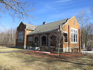
Greenfield is a town in Hillsborough County, New Hampshire, United States. The population was 1,716 at the 2020 census. Greenfield is home to the Crotched Mountain Rehabilitation Center, to Greenfield State Park, and to part of the Wapack Trail.

<span class="mw-page-title-main">Litchfield, New Hampshire</span> Town in New Hampshire, United States

Litchfield is a town in Hillsborough County, New Hampshire, United States. The population was 8,478 at the 2020 census.

<span class="mw-page-title-main">Lyndeborough, New Hampshire</span> Town in New Hampshire, United States

Lyndeborough is a town in Hillsborough County, New Hampshire, United States. The population was 1,702 at the 2020 census.

<span class="mw-page-title-main">Mason, New Hampshire</span> Town in New Hampshire, United States

Mason is a town in Hillsborough County, New Hampshire, United States. The population was 1,448 at the 2020 census. Mason, together with Wilton, is home to Russell-Abbott State Forest.

<span class="mw-page-title-main">Merrimack, New Hampshire</span> Town in New Hampshire, United States

Merrimack is a town in Hillsborough County, New Hampshire, United States. The population was 26,632 as of the 2020 census.

<span class="mw-page-title-main">Mont Vernon, New Hampshire</span> Town in New Hampshire, United States

Mont Vernon is a town in Hillsborough County, New Hampshire, United States. The population was 2,584 at the 2020 census, up from 2,409 at the 2010 census.

<span class="mw-page-title-main">New Boston, New Hampshire</span> Town in New Hampshire, United States

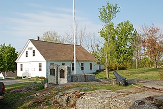
New Boston is a town in Hillsborough County, New Hampshire, United States. The population was 6,108 at the 2020 census, up from 5,321 at the 2010 census. New Boston is home to the annual Hillsborough County Agricultural Fair and the Molly Stark Cannon. The 1743 cannon, which appears on the town seal, was given by General John Stark to the New Boston Artillery Company after the Battle of Bennington.

<span class="mw-page-title-main">New Ipswich, New Hampshire</span> Town in New Hampshire, United States

New Ipswich is a town in Hillsborough County, New Hampshire, United States. The population was 5,204 at the 2020 census. New Ipswich, situated on the Massachusetts border, includes the villages of Bank, Davis, Gibson Four Corners, Highbridge, New Ipswich Center, Smithville, and Wilder, though these village designations no longer hold the importance they did in the past. The Wapack Trail passes through the community.

<span class="mw-page-title-main">Temple, New Hampshire</span> Town in New Hampshire, United States

Temple is a town in Hillsborough County, New Hampshire, United States. The population was 1,382 at the 2020 census. It is home to Temple Mountain State Reservation, formerly the Temple Mountain Ski Area.

<span class="mw-page-title-main">Souhegan River</span> River in New Hampshire, United States

The Souhegan River is a tributary of the Merrimack River in the northeastern United States. It is 33.8 miles (54.4 km) long, with a drainage area of 171 sq mi (440 km2), and flows north and east through southern New Hampshire to the Merrimack River. The river begins in New Ipswich, New Hampshire, at the junction of the river's South Branch and West Branch. Flowing northeast, it passes through the center of Greenville and descends through a narrow valley to Wilton, where it turns east. The river valley broadens below Wilton, and the river passes through the center of Milford, crosses the southern portion of Amherst, and enters the town of Merrimack. Shortly upstream of the town center, the river passes over Wildcat Falls, then crosses under the Everett Turnpike and U.S. Route 3 to reach the Merrimack River.

<span class="mw-page-title-main">Greenville, New Hampshire</span> Town in New Hampshire, United States

Greenville is a town in Hillsborough County, New Hampshire, United States. The population was 1,974 at the 2020 census, down from 2,105 at the 2010 census. It is located at the junctions of New Hampshire routes 31, 45, and 123.

<span class="mw-page-title-main">Milford (CDP), New Hampshire</span> Census-designated place in New Hampshire, United States

Milford is a census-designated place (CDP) and the main village in the town of Milford, Hillsborough County, New Hampshire, United States. The population of the CDP was 9,212 at the 2020 census, out of 16,131 in the entire town.

<span class="mw-page-title-main">Wilton (CDP), New Hampshire</span> Census-designated place in New Hampshire, United States

Wilton is a census-designated place (CDP) and the main village in the town of Wilton, Hillsborough County, New Hampshire, United States. The CDP extends east into the town of Milford as well. The population of the CDP was 1,324 at the 2020 census, up from 1,163 at the 2010 census.

<span class="mw-page-title-main">Wilton, New Hampshire</span> Town in New Hampshire, United States

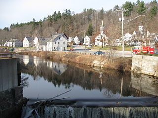
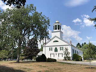
Wilton is a town in Hillsborough County, New Hampshire, United States. The population was 3,896 at the 2020 census. Like many small New England towns, it grew up around water-powered textile mills, but is now a rural bedroom community with some manufacturing and service employment. Wilton is home to the High Mowing School, a private preparatory school.

<span class="mw-page-title-main">Milford, New Hampshire</span> Town in New Hampshire, United States

Milford is a town in Hillsborough County, New Hampshire, United States, on the Souhegan River. The population was 16,131 at the 2020 census, up from 15,115 at the 2010 census. It is the retail and manufacturing center of a multi-town area known informally as the Souhegan Valley.

<span class="mw-page-title-main">New Hampshire Route 101</span> East-west highway in southern New Hampshire, U.S.

New Hampshire Route 101 is a state-maintained highway in southern New Hampshire extending from Keene to Hampton Beach. It is the major east–west highway in the southern portion of the state. Most of its eastern portion is a major freeway linking the greater Manchester area to the Seacoast Region. At 95.189 miles (153.192 km) in length, NH 101 nearly spans the entire width of southern New Hampshire.

<span class="mw-page-title-main">New Hampshire Route 13</span> North-south state highway in New Hampshire, US

New Hampshire Route 13 is a 43.38-mile (69.81 km) long north–south state highway in the state of New Hampshire, United States. The highway runs from Brookline to Concord.

<span class="mw-page-title-main">Dunstable, New Hampshire</span>

Dunstable, New Hampshire was a town located in Hillsborough County, New Hampshire. It has been divided into several current cities and towns, including Nashua, Hollis, Hudson, Litchfield, and Merrimack.

References

  1. 1 2 "2021 U.S. Gazetteer Files – New Hampshire". United States Census Bureau. Retrieved December 3, 2021.
  2. 1 2 3 "Amherst town, Hillsborough County, New Hampshire: 2020 DEC Redistricting Data (PL 94-171)". U.S. Census Bureau. Retrieved December 3, 2021.
  3. Hayward's New England Gazetteer (1839)
  4. 1 2 Statistics and Gazetteer of New-Hampshire (1875)
  5. Clark, Charles (2013) [1970]. The Eastern Frontier: The Settlement of Northern New England, 1610-1763. Alfred A. Knopf. ASIN   B00CGI3HDQ.
  6. "NH-SOS - 2020 Election Information".
  7. "The New Hampshire House of Representatives". www.gencourt.state.nh.us. Retrieved November 18, 2021.
  8. Foster, Debra H.; Batorfalvy, Tatianna N.; Medalie, Laura (1995). Water Use in New Hampshire: An Activities Guide for Teachers. U.S. Department of the Interior and U.S. Geological Survey.
  9. "Census of Population and Housing". Census.gov. Retrieved June 4, 2016.
  10. 1 2 3 "Profile of General Population and Housing Characteristics: 2010 Census Summary File 1 (DP-1): Amherst town, Hillsborough County, New Hampshire". U.S. Census Bureau, American Factfinder. Archived from the original on February 13, 2020. Retrieved February 7, 2017.
  11. "Selected Economic Characteristics: 2011-2015 American Community Survey 5-Year Estimates (DP03): Amherst town, Hillsborough County, New Hampshire". U.S. Census Bureau, American Factfinder. Archived from the original on February 13, 2020. Retrieved February 7, 2017.
  12. "School Administrative Unit 39" . Retrieved February 7, 2017.
  13. "ATHERTON, Charles Gordon, (1804 - 1853)". Biographical Directory of the United States Congress. Retrieved January 19, 2014.
  14. "ATHERTON, Charles Humphrey, (1773–1853)". Biographical Directory of the United States Congress. Retrieved January 19, 2014.
  15. "U.S.A. Basketball". May 1, 2017. Archived from the original on October 3, 2017.
  16. PORTRAIT AND BIOGRAPHICAL ALBUM OF Barry and Eaton Counties, Mich. 1891. p. 113.
  17. "BELL, Samuel, (1770 - 1850)". Biographical Directory of the United States Congress. Retrieved January 14, 2014.
  18. "Best Face Forward Portraits from the Society's Collection April through September 2009". The Stamford Historical Society. Retrieved January 19, 2014.
  19. "Buchanan, Hubert Elliot". POW Network. Retrieved November 13, 2015.
  20. "CLAGETT, Clifton, (1762 - 1829)". Biographical Directory of the United States Congress. Retrieved January 19, 2014.
  21. "FISK, Jonathan, (1778 - 1832)". Biographical Directory of the United States Congress. Retrieved January 19, 2014.
  22. "Horace Greeley". Encyclopædia Britannica. Retrieved January 19, 2014.
  23. Brooks, David (November 25, 2013). "Amherst's Jon 'Maddog' Hall is still leading the Linux legions, from do-it-yourselfers to supercomputers" . Nashua Telegraph . Retrieved January 19, 2014.
  24. "Joanne C. Head 1930-2021". Hollis Brookline News Online. January 15, 2021. Retrieved September 1, 2022.
  25. "Major League Overhaul". Amherst College. Retrieved January 19, 2014.
  26. Mackin, Jean (November 5, 2020). "18-year-old from Amherst elected to New Hampshire state house". WMUR. Retrieved February 2, 2021.
  27. "Representative Tony Labranche". 2020. Archived from the original on October 17, 2021. Retrieved February 2, 2021.
  28. "Amherst N.H." Hayward's New England Gazetteer (1839) page 28. Retrieved January 19, 2014.
  29. "The President's Wife, Jane Means Appleton Pierce: A Woman of Her Time" (PDF). NH History.org. Archived from the original (PDF) on February 1, 2014. Retrieved January 19, 2014.
  30. "Selee, Frank". National Baseball Hal of Fame Museum. Retrieved January 19, 2014.

Further reading