New Boston (CDP), New Hampshire

Last updated

New Boston, New Hampshire
Dodges Store, New Boston NH.jpg
Dodge's Store
USA New Hampshire location map.svg
Red pog.svg
New Boston
Usa edcp location map.svg
Red pog.svg
New Boston
Coordinates: 42°58′33″N71°41′35″W / 42.97583°N 71.69306°W / 42.97583; -71.69306
Country United States
State New Hampshire
County Hillsborough
Town New Boston
Area
[1]
  Total0.53 sq mi (1.38 km2)
  Land0.52 sq mi (1.34 km2)
  Water0.02 sq mi (0.04 km2)
Elevation
489 ft (149 m)
Population
 (2020)
  Total326
  Density631.78/sq mi (243.96/km2)
Time zone UTC-5 (Eastern (EST))
  Summer (DST) UTC-4 (EDT)
ZIP code
03070
Area code 603
FIPS code 33-50660
GNIS feature ID2806681

New Boston is a census-designated place (CDP) comprising the main village in the town of New Boston, Hillsborough County, New Hampshire, United States. As of the 2020 census, the population of the CDP was 326, [2] out of 6,108 in the entire town.

Contents

Geography

The CDP is in the center of the town of New Boston, on both sides of the South Branch Piscataquog River. The CDP extends west past Briar Hill Road, south down Route 13 to its crossing of the South Branch, east to Molly Stark Lane and Hilldale Lane, and north up Route 136 to Beard Road. [3]

New Hampshire Route 13 passes through the center of the community, leaving to the northeast down the South Branch valley along River Road, and leaving to the south along Mont Vernon Road. Route 13 leads northeast 7 miles (11 km) to Goffstown and south 11 miles (18 km) to Milford. New Hampshire Route 136 has its eastern terminus at Route 13 and leads west 7 miles (11 km) to Francestown, while New Hampshire Route 77 has it southern terminus at the same junction with NH 13 but leads north 9 miles (14 km) to Weare.

According to the U.S. Census Bureau, the New Boston CDP has a total area of 0.54 square miles (1.4 km2), of which 0.02 square miles (0.04 km2), or 3.22%, are water. [4] Via the South Branch of the Piscataquog, New Boston is part of the Merrimack River watershed.

Demographics

Historical population
CensusPop.Note
2020 326
U.S. Decennial Census [5]

Related Research Articles

<span class="mw-page-title-main">New Boston, New Hampshire</span> Town in New Hampshire, United States

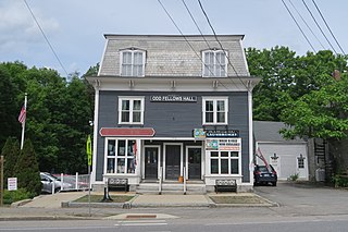
New Boston is a town in Hillsborough County, New Hampshire, United States. The population was 6,108 at the 2020 census, up from 5,321 at the 2010 census. New Boston is home to the annual Hillsborough County Agricultural Fair and the Molly Stark Cannon.

<span class="mw-page-title-main">Pinardville, New Hampshire</span> Census-designated place in New Hampshire, United States

Pinardville is a census-designated place (CDP) in the town of Goffstown, Hillsborough County, New Hampshire, United States. It is a suburban neighborhood adjacent to the city of Manchester. The population was 5,034 at the 2020 census. Pinardville has existed since 1906.

<span class="mw-page-title-main">Suncook, New Hampshire</span> Census-designated place in New Hampshire, United States

Suncook is a census-designated place (CDP) in Merrimack County, New Hampshire, United States. The population was 5,501 at the 2020 census. Approximately two-thirds of Suncook is located in the town of Pembroke, with the remainder in Allenstown.

<span class="mw-page-title-main">Wolfeboro (CDP), New Hampshire</span> Census-designated place in New Hampshire, United States

Wolfeboro is a census-designated place (CDP) in the town of Wolfeboro in Carroll County, New Hampshire, United States. It consists of the main village of Wolfeboro within the town, as well as the smaller village of Wolfeboro Falls. The population of the CDP was 3,300 at the 2020 census, out of 6,416 in the entire town of Wolfeboro.

<span class="mw-page-title-main">Marlborough (CDP), New Hampshire</span> Census-designated place in New Hampshire, United States

Marlborough is a census-designated place (CDP) and the main village in the town of Marlborough in Cheshire County, New Hampshire, United States. The population of the CDP was 1,066 at the 2020 census, out of 2,096 in the entire town.

<span class="mw-page-title-main">Winchester (CDP), New Hampshire</span> Census-designated place in New Hampshire, United States

Winchester is a census-designated place (CDP) and the main village in the town of Winchester in Cheshire County, New Hampshire, United States. The population of the CDP was 1,606 at the 2020 census, compared to 4,150 in the entire town.

Whitefield is a census-designated place (CDP) and the main village in the town of Whitefield in Coos County, New Hampshire, United States. The population of the CDP was 1,460 at the 2020 census, out of 2,490 people in the entire town of Whitefield.

<span class="mw-page-title-main">Hudson (CDP), New Hampshire</span> Census-designated place in New Hampshire, United States

Hudson is a census-designated place (CDP) and the urban center of the town of Hudson in Hillsborough County, New Hampshire, United States. The population of the CDP was 7,534 at the 2020 census, out of 25,394 in the entire town.

<span class="mw-page-title-main">Exeter (CDP), New Hampshire</span> Census-designated place in New Hampshire, United States

Exeter is a census-designated place (CDP) and the main village in the town of Exeter, Rockingham County, New Hampshire, United States. The population of the CDP was 10,109 at the 2020 census, out of 16,049 in the entire town.

<span class="mw-page-title-main">Raymond (CDP), New Hampshire</span> Census-designated place in New Hampshire, United States

Raymond is a census-designated place (CDP) and the main village in the town of Raymond, Rockingham County, New Hampshire, United States. The population of the CDP was 3,738 at the 2020 census, out of 10,684 in the entire town.

<span class="mw-page-title-main">Farmington (CDP), New Hampshire</span> Census-designated place in New Hampshire, United States

Farmington is a census-designated place (CDP) and the main village in the town of Farmington, Strafford County, New Hampshire, United States. The population of the CDP was 3,824 at the 2020 census, out of 6,722 in the entire town.

<span class="mw-page-title-main">Newport (CDP), New Hampshire</span> Census-designated place in New Hampshire, United States

Newport is a census-designated place (CDP) comprising the main village and surrounding rural land in the town of Newport, Sullivan County, New Hampshire, United States. The population of the CDP was 4,735 at the 2020 census, out of 6,299 in the entire town.

<span class="mw-page-title-main">New Hampshire Route 13</span> North-south state highway in New Hampshire, US

New Hampshire Route 13 is a 43.38-mile (69.81 km) long north–south state highway in the state of New Hampshire, United States. The highway runs from Brookline to Concord.

<span class="mw-page-title-main">Goffstown (CDP), New Hampshire</span> Census-designated place in New Hampshire, United States

Goffstown is a census-designated place (CDP) and the main village in the town of Goffstown in Hillsborough County, New Hampshire, United States. The population of the CDP was 3,366 at the 2020 census, out of 18,577 in the entire town.

Milton is a census-designated place (CDP) and the primary village in the town of Milton, Strafford County, New Hampshire, United States. The population of the CDP was 593 at the 2020 census, out of 4,482 in the entire town.

<span class="mw-page-title-main">Colebrook (CDP), New Hampshire</span> Census-designated place in New Hampshire, United States

Colebrook is a census-designated place (CDP) and the main village in the town of Colebrook, Coös County, New Hampshire, United States. The population of the CDP was 1,201 at the 2020 census, out of 2,084 in the entire town. The CDP population had dropped from 1,394 at the 2010 census.

<span class="mw-page-title-main">Loudon (CDP), New Hampshire</span> Census-designated place in New Hampshire, United States

Loudon is a census-designated place (CDP) and the main village in the town of Loudon in Merrimack County, New Hampshire, United States. The population of the CDP was 711 at the 2020 census, out of 5,576 in the entire town.

<span class="mw-page-title-main">Huntington (CDP), Massachusetts</span> Census-designated place in Massachusetts, United States

Huntington is a census-designated place (CDP) comprising the main village in the town of Huntington in Hampshire County, Massachusetts, United States. The population of the CDP was 936 at the 2010 census, out of a total town population of 2,180. It is part of the Springfield, Massachusetts Metropolitan Statistical Area.

<span class="mw-page-title-main">Francestown (CDP), New Hampshire</span> Census-designated place in New Hampshire, United States

Francestown is a census-designated place (CDP) and the main village in the town of Francestown, Hillsborough County, New Hampshire, United States. As of the 2020 census, the population of the CDP was 201, out of 1,610 in the entire town.

<span class="mw-page-title-main">Klondike Corner, New Hampshire</span> Census-designated place in New Hampshire, United States

Klondike Corner is a census-designated place (CDP) in the town of New Boston in Hillsborough County, New Hampshire, United States. As of the 2020 census the population was 652.

References

  1. "ArcGIS REST Services Directory". United States Census Bureau. Retrieved September 20, 2022.
  2. "New Boston CDP, New Hampshire: 2020 DEC Redistricting Data (PL 94-171)". U.S. Census Bureau. Retrieved December 10, 2021.
  3. "TIGERweb: New Boston CDP, New Hampshire". Geography Division, U.S. Census Bureau. Retrieved February 12, 2021.
  4. "2020 U.S. Gazetteer Files: New Hampshire". United States Census Bureau. Retrieved February 11, 2021.
  5. "Census of Population and Housing". Census.gov. Retrieved June 4, 2016.