Meredith, New Hampshire

Last updated

Meredith, New Hampshire
Town
Meredith aerial.jpg
Bird's-eye view of Meredith village
Meredith, NH Town Seal.png
Belknap-Meredith-NH.png
Coordinates: 43°39′28″N71°30′02″W / 43.65778°N 71.50056°W / 43.65778; -71.50056
Country United States
State New Hampshire
County Belknap
Incorporated 1768
Villages
Government
   Board of Selectmen
  Town ManagerTroy Brown
Area
[1]
  Total54.6 sq mi (141.3 km2)
  Land40.1 sq mi (103.8 km2)
  Water14.5 sq mi (37.5 km2)  26.56%
Elevation
508 ft (155 m)
Population
 (2020) [2]
  Total6,662
  Density166/sq mi (64.2/km2)
Time zone UTC−5 (Eastern)
  Summer (DST) UTC−4 (Eastern)
ZIP Code
03253
Area code 603
FIPS code33-47140
GNIS feature ID0873662
Website www.meredithnh.org

Meredith is a town in Belknap County, New Hampshire, United States. The population was 6,662 at the 2020 census. [2] Meredith is situated in the state's Lakes Region and serves as a major resort town. Meredith Village, the commercial center of the town, lies long the shores of Lake Winnipesaukee, and several other large lakes lie partially or completely within the town borders. It is home to the Stonedam Island Natural Area and the Winnipesaukee Scenic Railroad, and it serves as one of the ports of call for the MS Mount Washington.

Contents

Meredith Village, where 2,527 people resided at the 2020 census, [3] is defined as the Meredith census-designated place, and is located at the junction of U.S. Route 3 and New Hampshire Route 25 at the head of Meredith Bay on Lake Winnipesaukee.

History

Meredith village c. 1905 Bird's-eye View, Meredith, NH.jpg
Meredith village c.1905

Meredith was first known as "Palmer's Town" in honor of Samuel Palmer, a teacher of surveying and navigation who laid out much of the land surrounding Lake Winnipesaukee. In 1748, it was one of the first towns to have a charter granted by the Masonian Proprietors. Many grantees were from Salem, Massachusetts, so Palmer's Town was renamed "New Salem". It was settled in 1766 by Jacob Eaton and Colonel Ebenezer Smith, then regranted in 1768 by Governor John Wentworth and named after Sir William Meredith, 3rd Baronet, a member of Parliament who opposed taxation on the colonies.

Farmers grew corn, wheat, rye and potatoes, but the area became noted for apple orchards.

The water rights to the natural Measly Pond Brook (a.k.a. Corliss Brook) was purchased by John Jenness in 1795, and used to power a gristmill and sawmill in Meredith Village, though it was not the best local waterpower source. [4] [5] The brook drained Lake Waukewan into Lake Winnipesauke.

In 1800, John Bond Swasey inherited a 95-acre (38 ha) farm which covered most of what is now Meredith Village. After his marriage in 1809, he gradually purchased land on both sides of the Measly Pond Brook, related water rights, and several mills. [6]

From 1816 to 1818, Swasey constructed a 600-foot (180 m) rock-lined canal that redirected the flow from Lake Waukewan, and created a 30-foot (9.1 m) drop at a single rock-lined sluiceway at what is now the Mill Falls Marketplace. The new, more powerful waterfall ran sawmills, gristmills, cotton mills, and in 1895, the Meredith Electric Light Company. [7] [8]

By 1859 Meredith village had a sawmill, gristmill, shingle mill, blacksmith shop, harness-maker's shop and tannery. Situated at the outlet of Wickwas Lake, Meredith Center had a sawmill, gristmill and blacksmith shop. Connected by the Boston, Concord & Montreal Railroad in March 1849, the town became a summer resort. Passengers also arrived from the Alton Bay depot aboard steamboats, the most famous of which was the original SS Mount Washington, launched in 1872. Meredith remains a popular tourist destination.

In 1974, the Swasey family donated land to create Swasey Park on Lake Waukewan near the beginning of the canal. [7]

Geography

Plymouth Street c. 1920 Plymouth Street, Looking North, Meredith, NH.jpg
Plymouth Street c.1920

According to the United States Census Bureau, the town has a total area of 54.6 square miles (141.3 km2), of which 40.1 square miles (103.8 km2) are land and 14.5 square miles (37.5 km2), or 26.37%, are water. [1] The highest point in Meredith is the summit of Leavitt Mountain, elevation 1,414 feet (431 m) above sea level, in the southwestern part of town.

Meredith village is the commercial hub of the town, lying between the northern tip of Meredith Bay (one of several large arms of Lake Winnipesaukee) and Lake Waukewan. A second village, Meredith Center, is located near the shores of Lake Wickwas closer to the geographic center of the town. Meredith Center has much less commercial development than Meredith Village, being located near several protected state forests and wildlife areas.

The town is crossed by U.S. Route 3, New Hampshire Route 25, New Hampshire Route 104, and New Hampshire Route 106. It is bordered by the towns of Sanbornton to the southwest, New Hampton to the west, Center Harbor to the north, Moultonborough to the northeast across Lake Winnipesaukee, Gilford to the southeast, and Laconia to the south.

Like many other towns of the Lakes Region, Meredith is dominated by several large bodies of water. About half of the town's southeastern boundary with its neighbor Laconia is occupied by Lake Winnisquam, while the northern half of town lies within a peninsula, Meredith Neck, that separates Meredith Bay from the main body of Lake Winnipesaukee, giving Meredith an extensive coastline. Bear Island, the second largest on Winnipesaukee, and Stonedam Island, along with dozens of smaller islands are also part of the town. Several smaller lakes lie between Winnipesaukee and Winnisquam, including Wickwas Lake and Pemigewasset Lake. Lake Waukewan forms the western edge of the Meredith Village CDP and extends into neighboring New Hampton.

Adjacent municipalities

Climate

The Köppen Climate Classification subtype for this climate is "Dfb" (Humid Continental Climate).

Climate data for Meredith, New Hampshire, 1991–2020 normals, extremes 2009–2020
MonthJanFebMarAprMayJunJulAugSepOctNovDecYear
Record high °F (°C)60
(16)
66
(19)
82
(28)
88
(31)
92
(33)
94
(34)
96
(36)
93
(34)
92
(33)
81
(27)
70
(21)
61
(16)
96
(36)
Mean daily maximum °F (°C)29.1
(−1.6)
32.3
(0.2)
41.2
(5.1)
54.2
(12.3)
67.1
(19.5)
75.4
(24.1)
80.6
(27.0)
79.4
(26.3)
71.4
(21.9)
57.8
(14.3)
44.9
(7.2)
34.1
(1.2)
55.6
(13.1)
Daily mean °F (°C)21.2
(−6.0)
23.7
(−4.6)
32.1
(0.1)
44.3
(6.8)
56.2
(13.4)
65.4
(18.6)
70.5
(21.4)
69.1
(20.6)
61.5
(16.4)
48.8
(9.3)
37.6
(3.1)
27.4
(−2.6)
46.5
(8.0)
Mean daily minimum °F (°C)13.3
(−10.4)
15.0
(−9.4)
23.0
(−5.0)
34.3
(1.3)
45.3
(7.4)
55.3
(12.9)
60.3
(15.7)
58.8
(14.9)
51.6
(10.9)
39.8
(4.3)
30.2
(−1.0)
20.6
(−6.3)
37.3
(2.9)
Record low °F (°C)−14
(−26)
−15
(−26)
−3
(−19)
13
(−11)
30
(−1)
35
(2)
48
(9)
44
(7)
34
(1)
24
(−4)
1
(−17)
−10
(−23)
−15
(−26)
Average precipitation inches (mm)3.34
(85)
2.84
(72)
3.45
(88)
3.89
(99)
3.76
(96)
4.53
(115)
4.36
(111)
3.99
(101)
4.10
(104)
4.92
(125)
3.96
(101)
4.23
(107)
47.37
(1,204)
Average snowfall inches (cm)18.1
(46)
19.6
(50)
15.4
(39)
4.2
(11)
0.0
(0.0)
0.0
(0.0)
0.0
(0.0)
0.0
(0.0)
0.0
(0.0)
0.8
(2.0)
3.9
(9.9)
17.7
(45)
79.7
(202.9)
Average precipitation days (≥ 0.01 in)10.38.610.310.912.412.710.610.09.811.010.411.5128.5
Average snowy days (≥ 0.1 in)7.56.85.82.30.00.00.00.00.00.52.06.731.6
Source 1: NOAA [9]
Source 2: National Weather Service [10]

Demographics

Historical population
CensusPop.Note
1790 881
1800 1,60982.6%
1810 1,94020.6%
1820 2,41624.5%
1830 2,68311.1%
1840 3,34424.6%
1850 3,5215.3%
1860 1,944−44.8%
1870 1,807−7.0%
1880 1,800−0.4%
1890 1,642−8.8%
1900 1,7134.3%
1910 1,638−4.4%
1920 1,6802.6%
1930 1,90213.2%
1940 2,19215.2%
1950 2,2221.4%
1960 2,4349.5%
1970 2,90419.3%
1980 4,64660.0%
1990 4,8374.1%
2000 5,94322.9%
2010 6,2415.0%
2020 6,6626.7%
U.S. Decennial Census [2] [11]
Street scene in Meredith Center c. 1912 Road to Big Barn Doors, Meredith Center, NH.jpg
Street scene in Meredith Center c.1912

As of the 2010 census, there were 6,241 people, 2,708 households, and 1,777 families residing in the town. There were 4,728 housing units, of which 2,020, or 42.7%, were vacant. Of the vacant units, 1,710 were for seasonal or recreational use. The racial makeup of the town was 97.3% White, 0.3% African American, 0.2% Native American, 0.9% Asian, 0.0% Native Hawaiian or Pacific Islander, 0.3% some other race, and 1.0% from two or more races. Of the population, 1.1% were Hispanic or Latino of any race. [12]

Of the 2,941 households, 25.5% had children under the age of 18 living with them, 51.4% were headed by married couples living together, 9.9% had a female householder with no husband present, and 34.4% were non-families. Of all households, 27.5% were made up of individuals, and 11.6% were someone living alone who was 65 years of age or older. The average household size was 2.27, and the average family size was 2.71. [12]

In the town, 18.6% of the population were under the age of 18, 5.8% were from 18 to 24, 19.7% from 25 to 44, 34.9% from 45 to 64, and 20.8% were 65 years of age or older. The median age was 48.7 years. For every 100 females, there were 93.6 males. For every 100 females age 18 and over, there were 91.3 males. [12]

For the period 2011–2015, the estimated median annual income for a household was $63,028, and the median income for a family was $80,076. Male full-time workers had a median income of $62,944 versus $42,734 for females. The per capita income for the town was $36,510; 12.4% of the population and 8.7% of families were below the poverty line. Of the population, 22.5% under the age of 18 and 7.1% of those 65 or older were living in poverty. [13]

Government

In the New Hampshire Senate, Meredith is in the 2nd district, represented by Republican Bob Giuda. On the New Hampshire Executive Council, Meredith is in the 1st district, represented by Republican Joseph Kenney. In the United States House of Representatives, Meredith is in New Hampshire's 1st congressional district, represented by Democrat Chris Pappas.

Education

Meredith's Inter-Lakes Middle High School is home to the Inter-Lakes Community Auditorium, which plays host to the Summer Theatre in Meredith Village (formerly the Lakes Region Summer Theater) every summer. Inter-Lakes Elementary School serves children from Meredith and neighboring Center Harbor. The high school also includes students from the town of Sandwich.

Notable people

Original SS Mount Washington (1872-1939). Image c. 1920 Steamer Mt. Washington, Lake Winnipesaukee, NH.jpg
Original SS Mount Washington (1872–1939). Image c.1920

Sites of interest

Ridgefield Farm in 1917 Ridgefield Farm in Meredith, NH.jpg
Ridgefield Farm in 1917
Museums
Regional theatres and summer stock
Orchestras and other musical entertainment
Islands
Food and drink establishments

Related Research Articles

<span class="mw-page-title-main">Belknap County, New Hampshire</span> County in New Hampshire, United States

Belknap County is a county in the U.S. state of New Hampshire. As of the 2020 census, the population was 63,705. The county seat is Laconia. It is located in New Hampshire's Lakes Region, slightly southeast of the state's geographic center. Belknap County comprises the Laconia, NH Micropolitan Statistical Area, which in turn constitutes a portion of the Boston-Worcester-Providence, MA-RI-NH-CT Combined Statistical Area.

<span class="mw-page-title-main">Alton, New Hampshire</span> Town in New Hampshire, United States

Alton is a town in Belknap County, New Hampshire, United States. The population was 5,894 at the 2020 census, up from 5,250 at the 2010 census. It is home to Alton Bay State Forest and Mount Major State Forest.

<span class="mw-page-title-main">Belmont, New Hampshire</span> Town in New Hampshire, United States

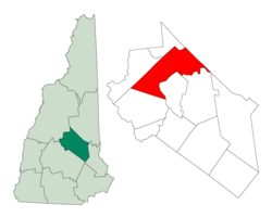
Belmont is a town in Belknap County, New Hampshire, United States. The population was 7,314 at the 2020 census.

<span class="mw-page-title-main">Center Harbor, New Hampshire</span> Town in New Hampshire, United States

Center Harbor is a town in Belknap County, New Hampshire, United States. As of the 2020 census, the town had a population of 1,040. It is situated between Lake Winnipesaukee and Squam Lake.

<span class="mw-page-title-main">Gilford, New Hampshire</span> Town in New Hampshire, United States

Gilford is a town in Belknap County, New Hampshire, United States. The population was 7,699 at the 2020 census, up from 7,126 at the 2010 census. Situated on Lake Winnipesaukee, Gilford is home to Governors Island, Ellacoya State Beach, Belknap Mountain State Forest, Gunstock Mountain Resort, and the Bank of New Hampshire Pavilion, a seasonal outdoor concert venue. The lakeside village of Glendale lies within Gilford's borders.

<span class="mw-page-title-main">Laconia, New Hampshire</span> City in New Hampshire, United States

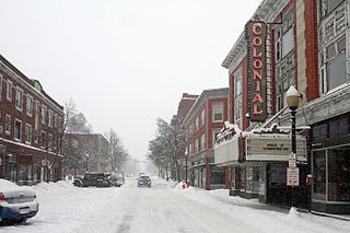
Laconia is a city in Belknap County, New Hampshire, United States. The population was 16,871 at the 2020 census, up from 15,951 at the 2010 census. It is the county seat of Belknap County. Laconia, situated between Lake Winnipesaukee and Lake Winnisquam, includes the villages of Lakeport and Weirs Beach. Each June, the city hosts Laconia Motorcycle Week, also more simply known as "Bike Week", one of the country's largest rallies.

<span class="mw-page-title-main">Sanbornton, New Hampshire</span> Town in New Hampshire, United States

Sanbornton is a town in Belknap County, New Hampshire, United States. The population was 3,026 at the 2020 census. It includes the villages of North Sanbornton and Gaza.

<span class="mw-page-title-main">Tilton, New Hampshire</span> Town in New Hampshire, United States

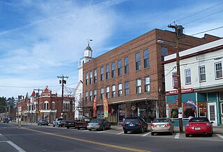
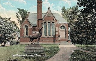
Tilton is a town on the Winnipesaukee River in Belknap County, New Hampshire, United States. The population was 3,962 at the 2020 census, up from 3,567 at the 2010 census. It includes the villages of Tilton and Lochmere and part of the village of Winnisquam. Tilton is home to the Tilton School, a private preparatory school.

<span class="mw-page-title-main">Moultonborough, New Hampshire</span> Town in New Hampshire, United States

Moultonborough is a town in Carroll County, New Hampshire, United States. The population was 4,918 at the 2020 census, up from 4,044 at the 2010 census. Moultonborough is bounded in large part by Lake Winnipesaukee in the southwest and to a lesser extent by Squam Lake in the northwestern corner. The town includes the census-designated place of Suissevale and the community of Lees Mill.

<span class="mw-page-title-main">Northfield, New Hampshire</span> Town in New Hampshire, United States

Northfield is a town in Merrimack County, New Hampshire, United States. The population was 4,872 at the 2020 census.

<span class="mw-page-title-main">Lake Winnipesaukee</span> Lake in New Hampshire, U.S.

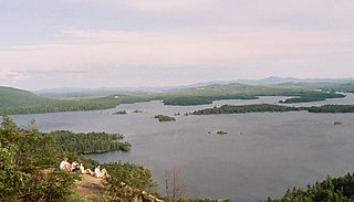
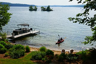
Lake Winnipesaukee is the largest lake in the U.S. state of New Hampshire, located in the Lakes Region at the foothills of the White Mountains. It is approximately 21 miles (34 km) long (northwest-southeast) and from 1 to 9 miles wide (northeast-southwest), covering 69 square miles (179 km2)—71 square miles (184 km2) when Paugus Bay is included—with a maximum depth of 180 feet (55 m). The center area of the lake is called The Broads.

<span class="mw-page-title-main">Meredith (CDP), New Hampshire</span> Census-designated place in New Hampshire, United States

Meredith is a census-designated place (CDP) and the main village in the town of Meredith in Belknap County, New Hampshire, United States. The population was 2,527 at the 2020 census, out of 6,662 in the entire town of Meredith.

<span class="mw-page-title-main">Lakes Region (New Hampshire)</span> Region in New Hampshire, United States

The Lakes Region of New Hampshire is located in the east-central part of the state, south of the White Mountains Region and extending to the Maine border. It is named for the numerous lakes in the region, the largest of which are Lake Winnipesaukee, Lake Winnisquam, Squam Lake, and Newfound Lake. The area comprises all of Belknap County, the southern portion of Carroll County, the eastern portion of Grafton County, and the northern portions of Strafford County and Merrimack County. The largest municipality is the city of Laconia.

<span class="mw-page-title-main">New Hampshire Route 11</span> State highway in central New Hampshire, US

New Hampshire Route 11 is a 108.223-mile-long (174.168 km) east–west state highway in New Hampshire, running completely across the central part of the state. Its western terminus is at the Vermont state line in Charlestown, where it continues west as Vermont Route 11. The eastern terminus is at the Maine state line in Rochester, where it crosses the border with U.S. Route 202 and continues as Maine State Route 11.

<span class="mw-page-title-main">New Hampshire Route 104</span> State highway in central New Hampshire, US

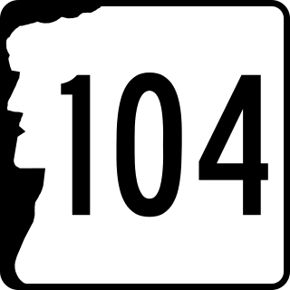
New Hampshire Route 104 is a 23.350-mile-long (37.578 km) secondary east–west highway in central New Hampshire, United States. The highway runs from Danbury to Meredith on Lake Winnipesaukee in the Lakes Region.

<span class="mw-page-title-main">Winnipesaukee River</span> River in New Hampshire, United States

The Winnipesaukee River is a 10.5-mile-long (16.9 km) river that connects Lake Winnipesaukee with the Pemigewasset and Merrimack rivers in Franklin, New Hampshire. The river is in the Lakes Region of central New Hampshire. The river's drainage area is approximately 488 square miles (1,264 km2).

<span class="mw-page-title-main">Lake Winnisquam</span> Lake in Belknap County, New Hampshire

Lake Winnisquam is in Belknap County in the Lakes Region of central New Hampshire, United States, in the communities of Meredith, Laconia, Sanbornton, Belmont, and Tilton. At 4,214 acres (1,705 ha), it is the fourth-largest lake entirely in New Hampshire. The lake is roughly triangular in shape, with the vertexes pointing north, east, and south. The lake lies along the path of the Winnipesaukee River, which enters the lake from its eastern corner and carries water from Lake Winnipesaukee via Paugus Bay and Opechee Bay. The river also flows south out of Winnisquam's southern corner, eventually joining the Merrimack River. The lake extends several miles north from the course of the Winnipesaukee River, which forms the lake's southeastern side, with the northern point being formed by the confluence of several smaller creeks near the village of Meredith Center. The lake has a maximum depth of 155 feet (47 m).

<span class="mw-page-title-main">Lake Waukewan</span>

Lake Waukewan is a 928-acre (3.76 km2) water body located in Belknap County in the Lakes Region of central New Hampshire, United States, in the towns of Meredith and New Hampton. The town of Center Harbor occupies part of the lake's northern shoreline.

<span class="mw-page-title-main">Lochmere, New Hampshire</span> Unincorporated community in New Hampshire, United States

Lochmere is an unincorporated community in the towns of Tilton and Belmont in Belknap County, New Hampshire, United States. It is located along U.S. Route 3 and New Hampshire Route 11, which connect the village with Laconia to the northeast and to the center of Tilton and to Franklin to the southwest. It is close to the Winnipesaukee River as it connects the outlet of Lake Winnisquam to the north with Silver Lake to the south.

References

  1. 1 2 "2020 U.S. Gazetteer Files – New Hampshire". United States Census Bureau. Retrieved October 28, 2021.
  2. 1 2 3 "Meredith town, Belknap County, New Hampshire: 2020 DEC Redistricting Data (PL 94-171)". U.S. Census Bureau. Retrieved October 28, 2021.
  3. "Meredith CDP, New Hampshire: 2020 DEC Redistricting Data (PL 94-171)". U.S. Census Bureau. Retrieved October 28, 2021.
  4. Discover the Rich History of Mill Falls
  5. "COMMUNITY PARK/WAUKEWAN CANAL - MEREDITH, NH". Lake Winnipesaukee Historical Society. Retrieved August 28, 2022.
  6. "Swasey park charrette booklet by FitzDesign, Inc. - Issuu".
  7. 1 2 Michael Kitch (December 13, 2016). "Plan to enhance Swasey Park presented". Laconia Daily Sun.
  8. Historic plaque at the falls, seen in at 1 min 14 sec.
  9. "U.S. Climate Normals Quick Access". National Oceanic and Atmospheric Administration. Retrieved August 3, 2022.
  10. "NOAA Online Weather Data – NWS Gray". National Weather Service. Retrieved February 18, 2023.
  11. "Census of Population and Housing". Census.gov. Retrieved June 4, 2016.
  12. 1 2 3 "Profile of General Population and Housing Characteristics: 2010 Census Summary File 1 (DP-1): Meredith town, Belknap County, New Hampshire". U.S. Census Bureau, American Factfinder. Archived from the original on February 13, 2020. Retrieved October 25, 2017.
  13. "Selected Economic Characteristics: 2011-2015 American Community Survey 5-Year Estimates (DP03): Meredith town, Belknap County, New Hampshire". U.S. Census Bureau, American Factfinder. Archived from the original on February 13, 2020. Retrieved October 25, 2017.
  14. "Bradford Anderson". NewHampshire.com. Retrieved January 22, 2014.
  15. "BELL, Samuel, (1770 - 1850)". Biographical Directory of the United States Congress. Retrieved January 22, 2014.
  16. Willey, George Franklyn (1903). State Builders: An Illustrated Historical and Biographical Record of the State of New Hampshire at the Beginning of the Twentieth Century. The New Hampshire Publishing Corporation. p. 392.
  17. "Annalee property sold for playhouse". New Hampshire Business Review. February 1, 2008. Retrieved August 9, 2008.

Further reading