Tilton Northfield, New Hampshire

Last updated

Tilton Northfield, New Hampshire
Pedestal, Island Park, Tilton Northfield NH.JPG
Island Park in the Winnipesaukee River between Tilton and Northfield
Merrimack County New Hampshire incorporated and unincorporated areas Tilton Northfield highlighted.svg
Location in Merrimack County and the state of New Hampshire
Coordinates: 43°26′36″N71°35′31″W / 43.44333°N 71.59194°W / 43.44333; -71.59194
Country United States
State New Hampshire
Counties Belknap, Merrimack
Towns Tilton, Northfield
Area
[1]
  Total3.24 sq mi (8.40 km2)
  Land3.13 sq mi (8.12 km2)
  Water0.11 sq mi (0.29 km2)
Elevation
450 ft (140 m)
Population
 (2020)
  Total3,324
  Density1,060.63/sq mi (409.50/km2)
Time zone UTC-5 (Eastern (EST))
  Summer (DST) UTC-4 (EDT)
ZIP code
03276
Area code 603
FIPS code 33-77100
GNIS feature ID2378093

Tilton Northfield is a census-designated place (CDP) representing two adjacent villages in the towns of Tilton in Belknap County and Northfield in Merrimack County in the U.S. state of New Hampshire. The CDP encompasses the town centers of both Tilton and Northfield, located on either side of the Winnipesaukee River. The population was 3,324 at the 2020 census. [2]

Contents

Geography

The CDP is located at 43°26′36″N71°35′31″W / 43.443236°N 71.591827°W / 43.443236; -71.591827 (43.443236, -71.591827). [3] In Tilton, it extends from the Franklin city line in the west to Interstate 93 in the east, and north to Clark Road, Colby Road, and just south of Aster Drive. The Northfield part of the CDP is bordered by I-93 to the east; the Winnipesaukee River, Williams Brook and Zion Hill Road to the west; and Forrest Road to the south. [4]

According to the United States Census Bureau, the CDP has a total area of 3.2 square miles (8.4 km2), of which 3.1 square miles (8.1 km2) are land and 0.12 square miles (0.3 km2), or 3.39%, are water. [5] The Winnipesaukee River flows through the center of the CDP, separating the villages of Northfield and Tilton, and running west to the Merrimack River in Franklin.

Demographics

Historical population
CensusPop.Note
1970 2,420
1980 2,5746.4%
1990 3,08119.7%
2000 3,2314.9%
2010 3,075−4.8%
2020 3,3248.1%
U.S. Decennial Census [6]

As of the census of 2010, the Tilton Northfield CDP had a population of 3,075, of whom 1,619 lived in the Tilton portion [7] and 1,456 lived in the Northfield portion. [8] A total of 1,212 households and 721 families resided in the CDP. There were 1,335 housing units, of which 123, or 9.2%, were vacant. The racial makeup of the CDP was 96.1% white, 0.7% African American, 0.4% Native American, 1.4% Asian, 0.0% Pacific Islander, 0.2% some other race, and 1.3% from two or more races. 1.0% of the population were Hispanic or Latino of any race. [9]

Of the 1,212 households in the CDP, 30.0% had children under the age of 18 living with them, 39.3% were headed by married couples living together, 14.9% had a female householder with no husband present, and 40.5% were non-families. 31.4% of all households were made up of individuals, and 10.6% were someone living alone who was 65 years of age or older. The average household size was 2.34, and the average family size was 2.93. [9]

20.9% of residents in the CDP were under the age of 18, 8.7% were from age 18 to 24, 26.7% were from 25 to 44, 27.2% were from 45 to 64, and 16.5% were 65 years of age or older. The median age was 40.4 years. For every 100 females, there were 107.8 males. For every 100 females age 18 and over, there were 107.6 males. [9]

For the period 2011–15, the estimated median annual income for a household was $52,712, and the median income for a family was $65,556. Male full-time workers had a median income of $39,978 versus $34,118 for females. The per capita income for the CDP was $23,615. 8.8% of the population and 6.0% of families were below the poverty line, along with 15.4% of people under the age of 18 and 3.3% of people 65 or older. [10]

Related Research Articles

<span class="mw-page-title-main">Belknap County, New Hampshire</span> County in New Hampshire, United States

Belknap County is a county in the U.S. state of New Hampshire. As of the 2020 census, the population was 63,705. The county seat is Laconia. It is located in New Hampshire's Lakes Region, slightly southeast of the state's geographic center. Belknap County comprises the Laconia, NH Micropolitan Statistical Area, which in turn constitutes a portion of the Boston-Worcester-Providence, MA-RI-NH-CT Combined Statistical Area.

<span class="mw-page-title-main">Alton, New Hampshire</span> Town in New Hampshire, United States

Alton is a town in Belknap County, New Hampshire, United States. The population was 5,894 at the 2020 census, up from 5,250 at the 2010 census. It is home to Alton Bay State Forest and Mount Major State Forest.

<span class="mw-page-title-main">Belmont, New Hampshire</span> Town in New Hampshire, United States

Belmont is a town in Belknap County, New Hampshire, United States. The population was 7,314 at the 2020 census.

<span class="mw-page-title-main">Tilton, New Hampshire</span> Town in New Hampshire, United States

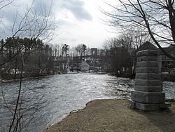
Tilton is a town on the Winnipesaukee River in Belknap County, New Hampshire, United States. The population was 3,962 at the 2020 census, up from 3,567 at the 2010 census. It includes the villages of Tilton and Lochmere and part of the village of Winnisquam. Tilton is home to the Tilton School, a private preparatory school.

<span class="mw-page-title-main">East Merrimack, New Hampshire</span> Census-designated place in New Hampshire, United States

East Merrimack is a census-designated place (CDP) in the town of Merrimack, Hillsborough County, New Hampshire, United States. There is no village center named "East Merrimack"; rather, the CDP refers to the region of the town of Merrimack lying east of the F. E. Everett Turnpike, overlapping portions of the villages of Reeds Ferry, Thornton's Ferry, and the center of Merrimack. The population was 5,176 at the 2020 census, up from 4,197 at the 2010 census.

<span class="mw-page-title-main">Franklin, New Hampshire</span> City in New Hampshire, United States

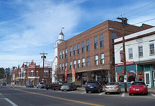
Franklin is a city in Merrimack County, New Hampshire, United States. At the 2020 census, the population was 8,741, the least of New Hampshire's 13 cities. Franklin includes the village of West Franklin.

<span class="mw-page-title-main">Northfield, New Hampshire</span> Town in New Hampshire, United States

Northfield is a town in Merrimack County, New Hampshire, United States. The population was 4,872 at the 2020 census.

<span class="mw-page-title-main">South Hooksett, New Hampshire</span> Census-designated place in New Hampshire, United States

South Hooksett is a census-designated place (CDP) within the town of Hooksett in Merrimack County, New Hampshire, United States. The population was 5,888 at the 2020 census. It is a suburban area adjacent to the city of Manchester, New Hampshire's largest city, and includes a mix of housing developments and large retail stores.

<span class="mw-page-title-main">Suncook, New Hampshire</span> Census-designated place in New Hampshire, United States

Suncook is a census-designated place (CDP) in Merrimack County, New Hampshire, United States. The population was 5,501 at the 2020 census. Approximately two-thirds of Suncook is located in the town of Pembroke, with the remainder in Allenstown.

<span class="mw-page-title-main">Winchester (CDP), New Hampshire</span> Census-designated place in New Hampshire, United States

Winchester is a census-designated place (CDP) and the main village in the town of Winchester in Cheshire County, New Hampshire, United States. The population of the CDP was 1,606 at the 2020 census, compared to 4,150 in the entire town.

<span class="mw-page-title-main">Hudson (CDP), New Hampshire</span> Census-designated place in New Hampshire, United States

Hudson is a census-designated place (CDP) and the urban center of the town of Hudson in Hillsborough County, New Hampshire, United States. The population of the CDP was 7,534 at the 2020 census, out of 25,394 in the entire town.

<span class="mw-page-title-main">Henniker (CDP), New Hampshire</span> Census-designated place in New Hampshire, United States

Henniker is a census-designated place (CDP) and the main village in the town of Henniker in Merrimack County, New Hampshire, United States. The population of the CDP was 3,166 at the 2020 census, out of 6,185 in the entire town. The CDP is the home to New England College.

<span class="mw-page-title-main">Hooksett (CDP), New Hampshire</span> Census-designated place in New Hampshire, United States

Hooksett is a census-designated place (CDP) in the town of Hooksett in Merrimack County, New Hampshire, United States. The CDP includes the historic central village of Hooksett as well as suburban and rural land surrounding it. The population of the CDP was 5,283 at the 2020 census, out of 14,871 in the entire town.

<span class="mw-page-title-main">Pittsfield (CDP), New Hampshire</span> Census-designated place in New Hampshire, United States

Pittsfield is a census-designated place (CDP) and the main village in the town of Pittsfield in Merrimack County, New Hampshire, United States. The population of the CDP was 1,570 at the 2020 census, out of 4,075 in the entire town.

<span class="mw-page-title-main">Londonderry (CDP), New Hampshire</span> Census-designated place in New Hampshire, United States

Londonderry is a census-designated place (CDP) within the town of Londonderry in Rockingham County, New Hampshire, United States. The population of the CDP was 11,645 at the 2020 census, out of 25,826 in the entire town.

<span class="mw-page-title-main">Melvin Village, New Hampshire</span> Census-designated place in New Hampshire, United States

Melvin Village is a census-designated place (CDP) within the town of Tuftonboro in Carroll County, New Hampshire, United States. Its population at the 2020 census was 273. The village is a summer vacation spot on Melvin Bay of Lake Winnipesaukee.

<span class="mw-page-title-main">Bradford (CDP), New Hampshire</span> Census-designated place in New Hampshire, United States

Bradford is a census-designated place (CDP) and the main village in the town of Bradford in Merrimack County, New Hampshire, United States. The population of the CDP was 372 at the 2020 census, out of 1,662 in the entire town.

<span class="mw-page-title-main">Loudon (CDP), New Hampshire</span> Census-designated place in New Hampshire, United States

Loudon is a census-designated place (CDP) and the main village in the town of Loudon in Merrimack County, New Hampshire, United States. The population of the CDP was 711 at the 2020 census, out of 5,576 in the entire town.

<span class="mw-page-title-main">New London (CDP), New Hampshire</span> Census-designated place in New Hampshire, United States

New London is a census-designated place (CDP) and the primary village in the town of New London in Merrimack County, New Hampshire, United States. The population of the CDP was 1,266 at the 2020 census, out of 4,400 in the entire town. The CDP includes the campus of Colby–Sawyer College.

<span class="mw-page-title-main">Warner (CDP), New Hampshire</span> Census-designated place in New Hampshire, United States

Warner is a census-designated place (CDP) and the main village in the town of Warner in Merrimack County, New Hampshire, United States. The population of the CDP was 453 at the 2020 census, out of 2,937 in the entire town.

References

  1. "ArcGIS REST Services Directory". United States Census Bureau. Retrieved September 20, 2022.
  2. "Tilton Northfield CDP, New Hampshire: 2020 DEC Redistricting Data (PL 94-171)". U.S. Census Bureau. Retrieved October 28, 2021.
  3. "US Gazetteer files: 2010, 2000, and 1990". United States Census Bureau. February 12, 2011. Retrieved April 23, 2011.
  4. "TIGERweb: Tilton Northfield CDP, New Hampshire". Geography Division, U.S. Census Bureau. Retrieved January 25, 2021.
  5. "2020 U.S. Gazetteer Files – New Hampshire". United States Census Bureau. Retrieved October 28, 2021.
  6. "Decennial Census Official Publications". Census.gov. Retrieved March 4, 2024.
  7. "Profile of General Population and Housing Characteristics: 2010 Census Summary File 1 (DP-1): Tilton Northfield CDP (part), Tilton town, Belknap County, New Hampshire". American Factfinder. U.S. Census Bureau. Archived from the original on February 14, 2020. Retrieved October 24, 2017.
  8. "Profile of General Population and Housing Characteristics: 2010 Census Summary File 1 (DP-1): Tilton Northfield CDP (part), Northfield town, Merrimack County, New Hampshire". American Factfinder. U.S. Census Bureau. Archived from the original on February 14, 2020. Retrieved October 24, 2017.
  9. 1 2 3 "Profile of General Population and Housing Characteristics: 2010 Census Summary File 1 (DP-1): Tilton Northfield CDP, New Hampshire". American Factfinder. U.S. Census Bureau. Archived from the original on February 13, 2020. Retrieved October 11, 2017.
  10. "Selected Economic Characteristics: 2011-2015 American Community Survey 5-Year Estimates (DP03): Tilton Northfield CDP, New Hampshire". American Factfinder. U.S. Census Bureau. Archived from the original on February 13, 2020. Retrieved October 11, 2017.