
Belknap County is a county in the U.S. state of New Hampshire. As of the 2020 census, the population was 63,705. The county seat is Laconia. It is located in New Hampshire's Lakes Region, slightly southeast of the state's geographic center. Belknap County comprises the Laconia, NH Micropolitan Statistical Area, which in turn constitutes a portion of the Boston-Worcester-Providence, MA-RI-NH-CT Combined Statistical Area.

Alton is a town in Belknap County, New Hampshire, United States. The population was 5,894 at the 2020 census, up from 5,250 at the 2010 census. It is home to Alton Bay State Forest and Mount Major State Forest.

Gilford is a town in Belknap County, New Hampshire, United States. The population was 7,699 at the 2020 census, up from 7,126 at the 2010 census. Situated on Lake Winnipesaukee, Gilford is home to Governors Island, Ellacoya State Beach, Belknap Mountain State Forest, Gunstock Mountain Resort, and the Bank of New Hampshire Pavilion, a seasonal outdoor concert venue. The lakeside village of Glendale lies within Gilford's borders.
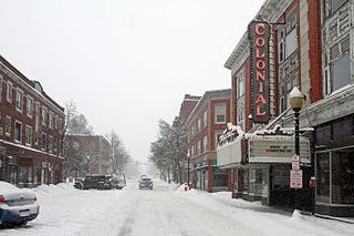
Laconia is a city in Belknap County, New Hampshire, United States. The population was 16,871 at the 2020 census, up from 15,951 at the 2010 census. It is the county seat of Belknap County. Laconia, situated between Lake Winnipesaukee and Lake Winnisquam, includes the villages of Lakeport and Weirs Beach. Each June, the city hosts Laconia Motorcycle Week, also more simply known as "Bike Week", one of the country's largest rallies.

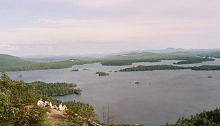
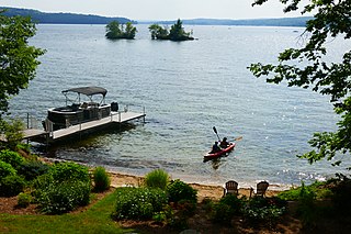
Lake Winnipesaukee is the largest lake in the U.S. state of New Hampshire, located in the Lakes Region at the foothills of the White Mountains. It is approximately 21 miles (34 km) long (northwest-southeast) and from 1 to 9 miles wide (northeast-southwest), covering 69 square miles (179 km2)—71 square miles (184 km2) when Paugus Bay is included—with a maximum depth of 180 feet (55 m). The center area of the lake is called The Broads.

Meredith is a town in Belknap County, New Hampshire, United States. The population was 6,662 at the 2020 census. Meredith is situated in the state's Lakes Region and serves as a major resort town. Meredith Village, the commercial center of the town, lies long the shores of Lake Winnipesaukee, and several other large lakes lie partially or completely within the town borders. It is home to the Stonedam Island Natural Area and the Winnipesaukee Scenic Railroad, and it serves as one of the ports of call for the MS Mount Washington.
The Lakes Region of New Hampshire is located in the east-central part of the state, south of the White Mountains Region and extending to the Maine border. It is named for the numerous lakes in the region, the largest of which are Lake Winnipesaukee, Lake Winnisquam, Squam Lake, and Newfound Lake. The area comprises all of Belknap County, the southern portion of Carroll County, the eastern portion of Grafton County, and the northern portions of Strafford County and Merrimack County. The largest municipality is the city of Laconia.

The Winnipesaukee River is a 10.5-mile-long (16.9 km) river that connects Lake Winnipesaukee with the Pemigewasset and Merrimack rivers in Franklin, New Hampshire. The river is in the Lakes Region of central New Hampshire. The river's drainage area is approximately 488 square miles (1,264 km2).
Lake Winnisquam is in Belknap County in the Lakes Region of central New Hampshire, United States, in the communities of Meredith, Laconia, Sanbornton, Belmont, and Tilton. At 4,214 acres (1,705 ha), it is the fourth-largest lake entirely in New Hampshire. The lake is roughly triangular in shape, with the vertexes pointing north, east, and south. The lake lies along the path of the Winnipesaukee River, which enters the lake from its eastern corner and carries water from Lake Winnipesaukee via Paugus Bay and Opechee Bay. The river also flows south out of Winnisquam's southern corner, eventually joining the Merrimack River. The lake extends several miles north from the course of the Winnipesaukee River, which forms the lake's southeastern side, with the northern point being formed by the confluence of several smaller creeks near the village of Meredith Center. The lake has a maximum depth of 155 feet (47 m).
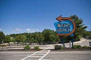
Weirs Beach is an area within the northern part of the city of Laconia in Belknap County, New Hampshire, United States. It is located on the southern shore of Lake Winnipesaukee. The cruise ship Mount Washington terminates there. It is a popular destination of bikers during Motorcycle Week every June.

The Plymouth & Lincoln Railroad is a class III shortline railroad operating on the Concord-Lincoln rail line in central New Hampshire, United States. The railroad consists of two distinct passenger operations, the Hobo Railroad, which offers passenger excursion trains in the White Mountains, and the Winnipesaukee Scenic Railroad, which operates passenger excursion trains along the shore of Lake Winnipesaukee in the Lakes Region of New Hampshire. In addition to passenger operations, the railroad owns the Lincoln Shops, a railroad equipment maintenance and repair facility located in Lincoln, New Hampshire.
Paugus Bay is a 1,227-acre (4.97 km2) water body located in Belknap County in the Lakes Region of central New Hampshire, United States, in the city of Laconia. A short channel at its north end connects it with Lake Winnipesaukee in the village of Weirs Beach, and a dam on its southern end separates it from Opechee Bay in the village of Lakeport. The bay is named after Chief Paugus, who fought in the Battle of Pequawket during Dummer's War. The 19th-century construction of the dam in Lakeport raised the elevation of Paugus Bay to that of Lake Winnipesaukee. Water flowing out of Paugus Bay travels down the Winnipesaukee River to the Merrimack River.
Opechee Bay is a 449-acre (1.82 km2) lake located in Belknap County in the Lakes Region of central New Hampshire, United States, in the city of Laconia. It is located directly downstream from Paugus Bay and Lake Winnipesaukee, and it connects by a one-mile segment of the Winnipesaukee River through the center of Laconia to Lake Winnisquam.
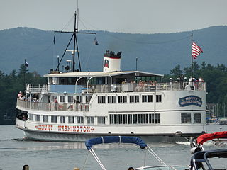
The MS Mount Washington is the flagship vessel of the Winnipesaukee Flagship Corporation. Its home port is on Lake Winnipesaukee in Laconia, New Hampshire, in the United States. The historic ship makes several ports of call around the lake during its scenic cruises in the spring, summer and fall months. Ice-Out is declared when the Mount Washington can get to all of its ports of call.

The New England Southern Railroad is a Class III shortline railroad that operates out of Canterbury, New Hampshire, and serves industries in central New Hampshire, in the United States.

Alton Bay is an unincorporated community in the town of Alton in Belknap County, New Hampshire, United States, and is located on Alton Bay, a 4-mile-long (6 km) cove of Lake Winnipesaukee which forms the southernmost point on the lake. The village is part of the Lakes Region, a popular resort area of the state.
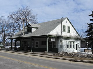
Alton Bay station is a former railroad station on New Hampshire Route 11 in Alton Bay, New Hampshire. Built in 1907 by the Boston and Maine Railroad, it is a surviving reminder of the importance of the railroad to the development of Alton Bay as a summer resort community. The building, now in use as a community center, was listed on the National Register of Historic Places in 1983 as Alton Bay Railroad Station.

Geneva Point Center (GPC) is a historic non-profit conference center and summer camp in a natural northern New England setting. Located in the town of Moultonborough, New Hampshire, the campus includes 184 acres (74 ha) of wooded nature trails and one mile of lakeshore on Lake Winnipesaukee. There are more than 90 structures on the site, including cabins, small family cottages and private lodge rooms. The property has the historic Winnipesaukee Inn. The oldest existing structure is a barn documented to exist in 1839 and is likely much older, perhaps even 18th century. The center has a long-running summer season ice cream shop that is open to the public.


