Alton (CDP), New Hampshire

Last updated

Alton, New Hampshire
USA New Hampshire location map.svg
Red pog.svg
Alton
Usa edcp location map.svg
Red pog.svg
Alton
Coordinates: 43°27′15″N71°13′8″W / 43.45417°N 71.21889°W / 43.45417; -71.21889
Country United States
State New Hampshire
County Belknap
Town Alton
Area
[1]
  Total0.50 sq mi (1.30 km2)
  Land0.47 sq mi (1.21 km2)
  Water0.03 sq mi (0.09 km2)
Elevation
562 ft (171 m)
Population
 (2020)
  Total499
  Density1,066.24/sq mi (411.80/km2)
Time zone UTC-5 (Eastern (EST))
  Summer (DST) UTC-4 (EDT)
ZIP Code
03809
Area code 603
FIPS code 33-00980
GNIS feature ID2629709

Alton is a census-designated place (CDP) and the main village in the town of Alton in Belknap County, New Hampshire, United States. The population was 499 at the 2020 census, [2] compared to 5,894 in the entire town of Alton.

Contents

Geography

The center of the CDP is at the junction of New Hampshire Routes 11 and 140 in the south-central part of the town of Alton, about 1 mile (1.6 km) south of the southern tip of Lake Winnipesaukee at Alton Bay. The Alton CDP borders include the Merrymeeting River to the south, New Hampshire Route 28 to the east, Wilbert Way and Barr Road to the north, and an unnamed lake along the Merrymeeting River to the west. [3] Route 28 leads north 11 miles (18 km) to Wolfeboro and southwest 13 miles (21 km) to Pittsfield, Route 11 leads southeast 17 miles (27 km) to Rochester and northwest 20 miles (32 km) to Laconia, and Route 140 leads west 12 miles (19 km) to Gilmanton.

According to the United States Census Bureau, the CDP has a total area of 0.50 square miles (1.3 km2), of which 0.46 square miles (1.2 km2) are land and 0.04 square miles (0.1 km2), or 6.77%, are water. [4]

Demographics

Historical population
CensusPop.Note
2010 501
2020 499−0.4%
U.S. Decennial Census [5]

As of the census of 2010, there were 501 people, 227 households, and 125 families residing in the CDP. There were 270 housing units, of which 43, or 15.9%, were vacant. 15 of the vacant units were seasonal or vacation properties. The racial makeup of the CDP was 99.0% white, 0.2% African American, 0.4% Asian, 0.4% from two or more races. 0.8% of the population were Hispanic or Latino of any race. [6]

Of the 227 households in the CDP, 25.6% had children under the age of 18 living with them, 39.6% were headed by married couples living together, 10.6% had a female householder with no husband present, and 44.9% were non-families. 36.1% of all households were made up of individuals, and 16.7% were someone living alone who was 65 years of age or older. The average household size was 2.21, and the average family size was 2.91. [6]

21.2% of residents in the CDP were under the age of 18, 9.4% were from age 18 to 24, 23.0% were from 25 to 44, 27.6% were from 45 to 64, and 19.0% were 65 years of age or older. The median age was 41.6 years. For every 100 females, there were 94.2 males. For every 100 females age 18 and over, there were 83.7 males. [6]

Related Research Articles

<span class="mw-page-title-main">Alton, New Hampshire</span> Town in New Hampshire, United States

Alton is a town in Belknap County, New Hampshire, United States. The population was 5,894 at the 2020 census, up from 5,250 at the 2010 census. It is home to Alton Bay State Forest and Mount Major State Forest.

<span class="mw-page-title-main">Meredith (CDP), New Hampshire</span> Census-designated place in New Hampshire, United States

Meredith is a census-designated place (CDP) and the main village in the town of Meredith in Belknap County, New Hampshire, United States. The population was 2,527 at the 2020 census, out of 6,662 in the entire town of Meredith.

<span class="mw-page-title-main">Wolfeboro (CDP), New Hampshire</span> Census-designated place in New Hampshire, United States

Wolfeboro is a census-designated place (CDP) in the town of Wolfeboro in Carroll County, New Hampshire, United States. It consists of the main village of Wolfeboro within the town, as well as the smaller village of Wolfeboro Falls. The population of the CDP was 3,300 at the 2020 census, out of 6,416 in the entire town of Wolfeboro.

<span class="mw-page-title-main">Hinsdale (CDP), New Hampshire</span> Census-designated place in New Hampshire, United States

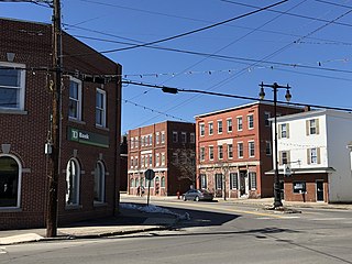
Hinsdale is a census-designated place (CDP) and the main village in the town of Hinsdale in Cheshire County, New Hampshire, United States. The population of the CDP was 1,485 at the 2020 census, out of 3,948 in the entire town of Hinsdale.

<span class="mw-page-title-main">Winchester (CDP), New Hampshire</span> Census-designated place in New Hampshire, United States

Winchester is a census-designated place (CDP) and the main village in the town of Winchester in Cheshire County, New Hampshire, United States. The population of the CDP was 1,606 at the 2020 census, compared to 4,150 in the entire town.

Lancaster is a census-designated place (CDP) and the main village in the town of Lancaster in Coos County, New Hampshire, United States. The population of the CDP was 1,941 at the 2020 census, out of 3,218 in the entire town of Lancaster.

<span class="mw-page-title-main">Bristol (CDP), New Hampshire</span> Census-designated place in New Hampshire, United States

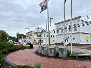
Bristol is a census-designated place (CDP) and the main village in the town of Bristol in Grafton County, New Hampshire, United States. The population of the CDP was 1,911 at the 2020 census, out of 3,244 in the entire town.

Hanover is a census-designated place (CDP) and the main village in the town of Hanover in Grafton County, New Hampshire, United States. The population of the CDP was 9,078 at the 2020 census, out of 11,870 in the entire town. The CDP includes the campus of Dartmouth College.

<span class="mw-page-title-main">Derry (CDP), New Hampshire</span> Census-designated place in New Hampshire, United States

Derry is a census-designated place (CDP) in the town of Derry in Rockingham County, New Hampshire, United States. The CDP comprises the urban center of the town, as well as the village of East Derry and connected suburban areas. The population of the CDP was 22,879 at the 2020 census, out of 34,317 in the entire town.

<span class="mw-page-title-main">Exeter (CDP), New Hampshire</span> Census-designated place in New Hampshire, United States

Exeter is a census-designated place (CDP) and the main village in the town of Exeter, Rockingham County, New Hampshire, United States. The population of the CDP was 10,109 at the 2020 census, out of 16,049 in the entire town.

<span class="mw-page-title-main">Hampton (CDP), New Hampshire</span> Census-designated place in New Hampshire, United States

Hampton is a census-designated place (CDP) comprising the town center and surrounding developed areas of the town of Hampton, Rockingham County, New Hampshire, United States. The population of the CDP was 9,597 at the 2020 census, out of 16,214 in the entire town.

<span class="mw-page-title-main">Raymond (CDP), New Hampshire</span> Census-designated place in New Hampshire, United States

Raymond is a census-designated place (CDP) and the main village in the town of Raymond, Rockingham County, New Hampshire, United States. The population of the CDP was 3,738 at the 2020 census, out of 10,684 in the entire town.

<span class="mw-page-title-main">Farmington (CDP), New Hampshire</span> Census-designated place in New Hampshire, United States

Farmington is a census-designated place (CDP) and the main village in the town of Farmington, Strafford County, New Hampshire, United States. The population of the CDP was 3,824 at the 2020 census, out of 6,722 in the entire town.

<span class="mw-page-title-main">West Stewartstown, New Hampshire</span> Census-designated place in New Hampshire, United States

West Stewartstown is a census-designated place in the town of Stewartstown in Coös County, New Hampshire, United States. It had a population of 263 at the 2020 census, down from 386 at the 2010 census.

<span class="mw-page-title-main">Bartlett (CDP), New Hampshire</span> Census-designated place in New Hampshire, United States

Bartlett is a census-designated place (CDP) and the main village in the town of Bartlett in Carroll County, New Hampshire, United States. The population was 351 at the 2020 census, out of 3,200 in the entire town of Bartlett.

<span class="mw-page-title-main">Belmont (CDP), New Hampshire</span> Census-designated place in New Hampshire, United States

Belmont is a census-designated place (CDP) and the main village in the town of Belmont in Belknap County, New Hampshire, United States. The population was 1,285 at the 2020 census, out of 7,314 in the entire town of Belmont.

<span class="mw-page-title-main">Seabrook Beach, New Hampshire</span> Census-designated place in New Hampshire, United States

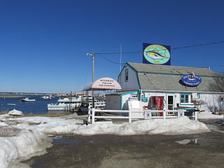
Seabrook Beach is a census-designated place in the town of Seabrook and partially in the town of Hampton in Rockingham County, New Hampshire, United States. It had a population of 1,078 at the 2020 census.

<span class="mw-page-title-main">Colebrook (CDP), New Hampshire</span> Census-designated place in New Hampshire, United States

Colebrook is a census-designated place (CDP) and the main village in the town of Colebrook, Coös County, New Hampshire, United States. The population of the CDP was 1,201 at the 2020 census, out of 2,084 in the entire town. The CDP population had dropped from 1,394 at the 2010 census.

<span class="mw-page-title-main">Hancock (CDP), New Hampshire</span> Census-designated place in New Hampshire, United States

Hancock is a census-designated place (CDP) and the main village in the town of Hancock in Hillsborough County, New Hampshire, United States. The population of the CDP was 213 at the 2020 census, out of 1,731 in the entire town.

Lincoln is a census-designated place (CDP) and the main village in the town of Lincoln in Grafton County, New Hampshire, United States. The population of the CDP was 969 at the 2020 census, out of 1,631 in the entire town.

References

  1. "ArcGIS REST Services Directory". United States Census Bureau. Retrieved September 20, 2022.
  2. "Alton CDP, New Hampshire: 2020 DEC Redistricting Data (PL 94-171)". U.S. Census Bureau. Retrieved October 28, 2021.
  3. "TIGERweb: Alton CDP, New Hampshire". Geography Division, U.S. Census Bureau. Retrieved August 25, 2017.
  4. "2020 U.S. Gazetteer Files – New Hampshire". United States Census Bureau. Retrieved October 28, 2021.
  5. "Decennial Census Official Publications". Census.gov. Retrieved March 4, 2024.
  6. 1 2 3 "Profile of General Population and Housing Characteristics: 2010 Census Summary File 1 (DP-1): Alton CDP, New Hampshire". American Factfinder. U.S. Census Bureau. Archived from the original on February 13, 2020. Retrieved October 11, 2017.