Lovell is a town in Oxford County, Maine, United States. The population was 1,104 at the 2020 census. Lovell is the site of Kezar Lake, a resort area.

Parsonsfield is a town in York County, Maine, United States. The population was just 1,791 at the 2020 census. Parsonsfield includes the villages of Kezar Falls, Parsonsfield, and North, East and South Parsonsfield. It is part of the Portland–South Portland–Biddeford, Maine metropolitan statistical area.

Royalston is a town in Worcester County, Massachusetts, United States. The population was 1,250 at the 2020 census.
Sandwich is a town in Carroll County, New Hampshire, United States. Its population was 1,466 at the 2020 census. Sandwich includes the villages of Center Sandwich and North Sandwich. Part of the White Mountain National Forest is in the north, and part of Squam Lake is in the southwestern corner of the town. As such, Sandwich lies on the boundary between New Hampshire's Lakes Region and White Mountains Region. The Sandwich Range of the White Mountains lies partially within the town, as does the namesake Sandwich Mountain. The town is home to the Sandwich Fair, a popular agricultural fair that occurs every October.

Tamworth is a town in Carroll County, New Hampshire, United States. The population was 2,812 at the 2020 census. Tamworth includes the villages of Chocorua, South Tamworth, Wonalancet, and Whittier. The White Mountain National Forest is to the north. The town is home to Hemenway State Forest in the north and White Lake State Park in the southeast.

Hebron is a town in Grafton County, New Hampshire, United States. The population was 632 at the 2020 census. Settlements include the town center and the village of East Hebron.

Goffstown is a town in Hillsborough County, New Hampshire, United States. The population was 18,577 at the 2020 census. The compact center of town, where 3,366 people resided at the 2020 census, is defined by the U.S. Census Bureau as the Goffstown census-designated place and is located at the junctions of New Hampshire routes 114 and 13. Goffstown also includes the villages of Grasmere and Pinardville. The town is home to Saint Anselm College, the Goffstown Giant Pumpkin Regatta, and was the location of the New Hampshire State Prison for Women, prior to the prison's relocation to Concord in 2018.
Weare is a town in Hillsborough County, New Hampshire, United States. The population was 9,092 at the 2020 census. It is close to two important New Hampshire cities, Manchester and Concord.

New London is a town in Merrimack County, New Hampshire, United States. The population was 4,400 at the 2020 census. The town is the home of Colby–Sawyer College, site of the Gordon Research Conferences since 1947.

Newbury is a town in Merrimack County, New Hampshire, United States. The population was 2,172 at the 2020 census. Newbury is home to part of Lake Sunapee, including Mount Sunapee State Park Beach. Mount Sunapee Resort, a ski area in Mount Sunapee State Park, is in the west. The town includes the villages of Newbury, Blodgett Landing and South Newbury.

Sutton is a town in Merrimack County, New Hampshire, United States. The population was 1,978 at the 2020 census. Sutton includes the villages of Sutton Mills, North Sutton, South Sutton and East Sutton. North Sutton is home to Wadleigh State Park on Kezar Lake.

Wilmot is a town in Merrimack County, New Hampshire, United States. The population was 1,407 at the 2020 census. The town includes the communities of Wilmot, Wilmot Flat, and North Wilmot.

Candia is a town in Rockingham County, New Hampshire, United States. The population was 4,013 at the 2020 census. The town includes the villages of Candia, Candia Four Corners and East Candia.

New Hampshire Route 114 is a 60.433-mile-long (97.257 km) secondary north–south highway in central New Hampshire. The highway runs between Bedford in Hillsborough County and Grantham in Sullivan County.

New Hampshire Route 25 is a 96.62-mile (155.49 km) long east–west state highway in New Hampshire. It runs completely across the state from Vermont to Maine.
Vermont Route 14 (VT 14) is a 108.946-mile-long (175.332 km) north–south state highway in northeastern Vermont, United States. It extends from U.S. Route 4 (US 4) and US 5 in White River Junction to VT 100 in Newport. Between White River Junction and the city of Barre, the route parallels Interstate 89 (I-89). VT 14 was originally designated in 1922 as part of the New England road marking system. Its north end was truncated in 1926 as a result of the designation of US 2 but was extended north along an old alignment of VT 12 in the 1960s.

The Cold River is a 16.7-mile-long (26.9 km) river in western Maine in the United States. It very briefly enters New Hampshire as well. It is part of the Saco River drainage basin.

The Ossipee River is an 18.3-mile-long (29.5 km) river in eastern New Hampshire and western Maine in the United States. It is a tributary of the Saco River, which flows southeast to the Atlantic Ocean at Saco, Maine.
The Lane River is an 8.5-mile-long (13.7 km) stream in central New Hampshire in the United States. It is a tributary of the Warner River, part of the Contoocook River watershed.
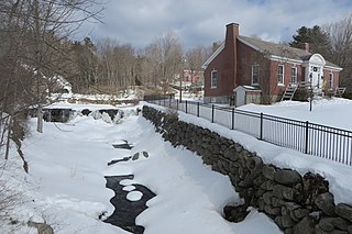
Wadleigh State Park is a public recreation area located on the south shore of 170-acre (69 ha) Kezar Lake in Sutton, New Hampshire. The state park has a bathhouse and playing fields and offers opportunities for swimming, picnicking, fishing, and boating.