Hooksett (CDP), New Hampshire

Last updated

Hooksett, New Hampshire
Geo A Robie and Son, Hooksett NH.jpg
Geo. A. Robie and Son, Hooksett NH.jpg
USA New Hampshire location map.svg
Red pog.svg
Hooksett
Usa edcp location map.svg
Red pog.svg
Hooksett
Coordinates: 43°5′48″N71°27′54″W / 43.09667°N 71.46500°W / 43.09667; -71.46500
Country United States
State New Hampshire
County Merrimack
Town Hooksett
Area
[1]
  Total5.84 sq mi (15.13 km2)
  Land5.40 sq mi (13.98 km2)
  Water0.44 sq mi (1.15 km2)
Elevation
210 ft (60 m)
Population
 (2020)
  Total5,283
  Density978.51/sq mi (377.83/km2)
Time zone UTC-5 (Eastern (EST))
  Summer (DST) UTC-4 (EDT)
ZIP code
03106
Area code 603
FIPS code 33-37220
GNIS feature ID2378073

Hooksett is a census-designated place (CDP) in the town of Hooksett in Merrimack County, New Hampshire, United States. The CDP includes the historic central village of Hooksett as well as suburban and rural land surrounding it. The population of the CDP was 5,283 at the 2020 census, [2] out of 14,871 in the entire town.

Contents

Geography

The CDP occupies the central to northern parts of the town of Hooksett, on both sides of the Merrimack River. The village of Hooksett is at the center of the CDP, where Main Street crosses the Merrimack. The CDP extends north to the Bow and Allenstown town lines and south to include the Granite Hill Villages housing development. Interstate 93 forms the western edge of the CDP, with access from Exit 11 at the Hooksett toll plaza, and U.S. Route 3 runs through the eastern side. New Hampshire Route 3A passes through the center of the CDP along the west side of the Merrimack River. Hooksett is bordered to the north by the Suncook CDP in the town of Allenstown. [3]

Concord, the state capital, is 9 miles (14 km) to the north via I-93 or NH 3A and 10 miles (16 km) to the north via US 3, while Manchester, the largest city in the state, is 8 miles (13 km) to the south.

According to the U.S. Census Bureau, the Hooksett CDP has a total area of 5.8 square miles (15.1 km2), of which 5.4 square miles (14.0 km2) are land and 0.4 square miles (1.1 km2), or 7.60%, are water. [4]

Demographics

Historical population
CensusPop.Note
1970 1,303
1980 1,86843.4%
1990 2,57337.7%
2000 3,60940.3%
2010 4,14714.9%
2020 5,28327.4%
U.S. Decennial Census [5]

As of the census of 2010, there were 4,147 people, 1,819 households, and 1,166 families residing in the CDP. There were 1,945 housing units, of which 126, or 6.5%, were vacant. The racial makeup of the CDP was 93.9% white, 1.6% African American, 0.1% Native American, 1.8% Asian, 0.1% Pacific Islander, 0.8% some other race, and 1.7% from two or more races. 2.3% of the population were Hispanic or Latino of any race. [6]

Of the 1,819 households in the CDP, 27.3% had children under the age of 18 living with them, 49.1% were headed by married couples living together, 10.8% had a female householder with no husband present, and 35.9% were non-families. 26.7% of all households were made up of individuals, and 8.4% were someone living alone who was 65 years of age or older. The average household size was 2.28, and the average family size was 2.75. [6]

19.7% of residents in the CDP were under the age of 18, 6.6% were from age 18 to 24, 28.2% were from 25 to 44, 30.6% were from 45 to 64, and 14.9% were 65 years of age or older. The median age was 41.9 years. For every 100 females, there were 89.3 males. For every 100 females age 18 and over, there were 87.5 males. [6]

For the period 2011–15, the estimated median annual income for a household was $68,294, and the median income for a family was $74,658. Male full-time workers had a median income of $45,516 versus $46,434 for females. The per capita income for the CDP was $32,689. 3.8% of the population and 1.8% of families were below the poverty line, along with 0% of people under the age of 18 and 2.7% of people 65 or older. [7]

Related Research Articles

<span class="mw-page-title-main">Merrimack County, New Hampshire</span> County in New Hampshire, United States

Merrimack County is a county in the U.S. state of New Hampshire. As of the 2020 Census, the population was 153,808, making it the third most populous county in New Hampshire. Its county seat is Concord, the state capital. The county was organized in 1823 from parts of Hillsborough and Rockingham counties, and is named for the Merrimack River. Merrimack County comprises the Concord, NH Micropolitan Statistical Area, which in turn constitutes a portion of the Boston–Worcester–Providence, MA–RI–NH–CT Combined Statistical Area. In 2010, the center of population of New Hampshire was located in Merrimack County, in the town of Pembroke.

<span class="mw-page-title-main">East Merrimack, New Hampshire</span> Census-designated place in New Hampshire, United States

East Merrimack is a census-designated place (CDP) in the town of Merrimack, Hillsborough County, New Hampshire, United States. There is no village center named "East Merrimack"; rather, the CDP refers to the region of the town of Merrimack lying east of the F. E. Everett Turnpike, overlapping portions of the villages of Reeds Ferry, Thornton's Ferry, and the center of Merrimack. The population was 5,176 at the 2020 census, up from 4,197 at the 2010 census.

<span class="mw-page-title-main">Allenstown, New Hampshire</span> Town in New Hampshire, United States

Allenstown is a town in Merrimack County, New Hampshire, United States. The population was 4,707 at the 2020 census, up from 4,322 at the 2010 census. Allenstown includes a portion of the village of Suncook. Just over one-half of the town's area is covered by Bear Brook State Park.

<span class="mw-page-title-main">Bradford, New Hampshire</span> Town in New Hampshire, United States

Bradford is a town in Merrimack County, New Hampshire, United States. The population was 1,662 at the 2020 census. The main village of the town, where 372 people resided at the 2020 census, is defined as the Bradford census-designated place (CDP), and is located in the northeast part of the town, west of the junction of New Hampshire routes 103 and 114. The town also includes the village of Bradford Center.

<span class="mw-page-title-main">Dunbarton, New Hampshire</span> Town in New Hampshire, United States

Dunbarton is a town in Merrimack County, New Hampshire, United States. The population was 3,005 at the 2020 census, up from 2,758 at the 2010 census.

<span class="mw-page-title-main">South Hooksett, New Hampshire</span> Census-designated place in New Hampshire, United States

South Hooksett is a census-designated place (CDP) within the town of Hooksett in Merrimack County, New Hampshire, United States. The population was 5,888 at the 2020 census. It is a suburban area adjacent to the city of Manchester, New Hampshire's largest city, and includes a mix of housing developments and large retail stores.

<span class="mw-page-title-main">Suncook, New Hampshire</span> Census-designated place in New Hampshire, United States

Suncook is a census-designated place (CDP) in Merrimack County, New Hampshire, United States. The population was 5,501 at the 2020 census. Approximately two-thirds of Suncook is located in the town of Pembroke, with the remainder in Allenstown.

<span class="mw-page-title-main">Tilton Northfield, New Hampshire</span> Census-designated place in New Hampshire, United States

Tilton Northfield is a census-designated place (CDP) representing two adjacent villages in the towns of Tilton in Belknap County and Northfield in Merrimack County in the U.S. state of New Hampshire. The CDP encompasses the town centers of both Tilton and Northfield, located on either side of the Winnipesaukee River. The population was 3,324 at the 2020 census.

<span class="mw-page-title-main">Bristol (CDP), New Hampshire</span> Census-designated place in New Hampshire, United States

Bristol is a census-designated place (CDP) and the main village in the town of Bristol in Grafton County, New Hampshire, United States. The population of the CDP was 1,911 at the 2020 census, out of 3,244 in the entire town.

<span class="mw-page-title-main">Plymouth (CDP), New Hampshire</span> Census-designated place in New Hampshire, United States

Plymouth is a census-designated place (CDP) and the main village in the town of Plymouth in Grafton County, New Hampshire, United States. Its population was 4,730 at the 2020 census, out of 6,682 in the entire town. The CDP includes the campus of Plymouth State University.

<span class="mw-page-title-main">Hudson (CDP), New Hampshire</span> Census-designated place in New Hampshire, United States

Hudson is a census-designated place (CDP) and the urban center of the town of Hudson in Hillsborough County, New Hampshire, United States. The population of the CDP was 7,534 at the 2020 census, out of 25,394 in the entire town.

<span class="mw-page-title-main">Henniker (CDP), New Hampshire</span> Census-designated place in New Hampshire, United States

Henniker is a census-designated place (CDP) and the main village in the town of Henniker in Merrimack County, New Hampshire, United States. The population of the CDP was 3,166 at the 2020 census, out of 6,185 in the entire town. The CDP is the home to New England College.

<span class="mw-page-title-main">Hooksett, New Hampshire</span> Town in New Hampshire, United States

Hooksett is a town in Merrimack County, New Hampshire, United States. The population was 14,871 at the 2020 census, up from 13,451 at the 2010 census. The town is located between Manchester, the state's largest city, and Concord, the state capital. A prominent landmark is Robie's Country Store, a National Historic Landmark and a frequent stop for presidential candidates during the New Hampshire primary.

<span class="mw-page-title-main">Pittsfield (CDP), New Hampshire</span> Census-designated place in New Hampshire, United States

Pittsfield is a census-designated place (CDP) and the main village in the town of Pittsfield in Merrimack County, New Hampshire, United States. The population of the CDP was 1,570 at the 2020 census, out of 4,075 in the entire town.

<span class="mw-page-title-main">Derry (CDP), New Hampshire</span> Census-designated place in New Hampshire, United States

Derry is a census-designated place (CDP) in the town of Derry in Rockingham County, New Hampshire, United States. The CDP comprises the urban center of the town, as well as the village of East Derry and connected suburban areas. The population of the CDP was 22,879 at the 2020 census, out of 34,317 in the entire town.

<span class="mw-page-title-main">Londonderry (CDP), New Hampshire</span> Census-designated place in New Hampshire, United States

Londonderry is a census-designated place (CDP) within the town of Londonderry in Rockingham County, New Hampshire, United States. The population of the CDP was 11,645 at the 2020 census, out of 25,826 in the entire town.

<span class="mw-page-title-main">Bradford (CDP), New Hampshire</span> Census-designated place in New Hampshire, United States

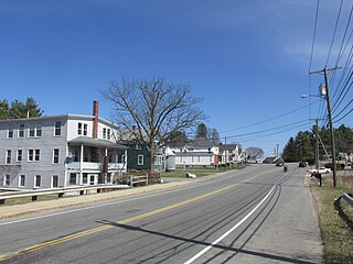
Bradford is a census-designated place (CDP) and the main village in the town of Bradford in Merrimack County, New Hampshire, United States. The population of the CDP was 372 at the 2020 census, out of 1,662 in the entire town.

<span class="mw-page-title-main">Loudon (CDP), New Hampshire</span> Census-designated place in New Hampshire, United States

Loudon is a census-designated place (CDP) and the main village in the town of Loudon in Merrimack County, New Hampshire, United States. The population of the CDP was 711 at the 2020 census, out of 5,576 in the entire town.

<span class="mw-page-title-main">New London (CDP), New Hampshire</span> Census-designated place in New Hampshire, United States

New London is a census-designated place (CDP) and the primary village in the town of New London in Merrimack County, New Hampshire, United States. The population of the CDP was 1,266 at the 2020 census, out of 4,400 in the entire town. The CDP includes the campus of Colby–Sawyer College.

<span class="mw-page-title-main">Warner (CDP), New Hampshire</span> Census-designated place in New Hampshire, United States

Warner is a census-designated place (CDP) and the main village in the town of Warner in Merrimack County, New Hampshire, United States. The population of the CDP was 453 at the 2020 census, out of 2,937 in the entire town.

References

  1. "ArcGIS REST Services Directory". United States Census Bureau. Retrieved September 20, 2022.
  2. "Hooksett CDP, New Hampshire: 2020 DEC Redistricting Data (PL 94-171)". U.S. Census Bureau. Retrieved December 17, 2021.
  3. "TIGERweb: Hooksett CDP, New Hampshire". Geography Division, U.S. Census Bureau. Retrieved September 27, 2017.
  4. "2021 U.S. Gazetteer Files – New Hampshire". United States Census Bureau. Retrieved December 17, 2021.
  5. "Decennial Census Official Publications". Census.gov. Retrieved March 4, 2024.
  6. 1 2 3 "Profile of General Population and Housing Characteristics: 2010 Census Summary File 1 (DP-1): Hooksett CDP, New Hampshire". U.S. Census Bureau, American Factfinder. Archived from the original on February 13, 2020. Retrieved September 27, 2017.
  7. "Selected Economic Characteristics: 2011-2015 American Community Survey 5-Year Estimates (DP03): Hooksett CDP, New Hampshire". U.S. Census Bureau, American Factfinder. Archived from the original on February 13, 2020. Retrieved September 27, 2017.