Allenstown, New Hampshire

Last updated

Allenstown, New Hampshire
Allenstown Municipal Building, Allenstown NH.JPG
Allenstown Municipal Building
Allenstown, NH Town Seal.png
Merrimack County New Hampshire incorporated and unincorporated areas Allenstown highlighted.svg
Location in Merrimack County and the state of New Hampshire.
Coordinates: 43°09′28″N71°24′17″W / 43.15778°N 71.40472°W / 43.15778; -71.40472
Country United States
State New Hampshire
County Merrimack
Incorporated 1831
VillagesAllenstown
Suncook (part)
Government
   Board of Selectmen Scott McDonald, Chair
Maureen Higham
Keith Klawes
Sandra McKenney
Jim Rodger
   Town Administrator Derik Goodine
Area
[1]
  Total20.6 sq mi (53.3 km2)
  Land20.5 sq mi (53.0 km2)
  Water0.1 sq mi (0.3 km2)  0.55%
Elevation
340 ft (100 m)
Population
 (2020) [2]
  Total4,707
  Density230/sq mi (88.8/km2)
Time zone UTC-5 (Eastern)
  Summer (DST) UTC-4 (Eastern)
ZIP code
03275
Area code 603
FIPS code 33-00660
GNIS feature ID0873528
Website www.allenstownnh.gov

Allenstown is a town in Merrimack County, New Hampshire, United States. The population was 4,707 at the 2020 census, [2] up from 4,322 at the 2010 census. [3] Allenstown includes a portion of the village of Suncook. Just over one-half of the town's area is covered by Bear Brook State Park.

Contents

History

Allenstown takes its name from 17th-century provincial governor Samuel Allen. It was granted in 1721 but not incorporated until July 2, 1831. [4] A part of neighboring Bow was annexed to Allenstown in 1815, and a portion of Hooksett was annexed in 1853. [5] [6]

Most of the town's earliest settlement occurred in the eastern part of town along Deerfield Road, around the area now mostly occupied by Bear Brook State Park, and where the Old Allenstown Meeting House is located. Following the Civil War, the town's population shifted from the east to the west part of town, centered around the confluence of the Merrimack and Suncook rivers, in the area now known as Suncook. [7]

Railroads were instrumental to the development of Allenstown. First, the Concord and Portsmouth Railroad running from Candia and points east arrived in the 1852, but that line was subsequently torn up from Candia to Allenstown, with a new branch being built from the Suncook River down to the Hooksett Falls in 1862. The Suncook Valley Railroad would follow in 1869, which ran northeast along the river, first to Pittsfield and later, to Center Barnstead. While the Suncook depot was just across the river in Pembroke, the Suncook Valley Railroad built Allenstown another depot in the northern part of town, along what is now Verville Road. In 1902, the Concord & Manchester Electric Railway came to town, connecting its two namesakes. It crossed the Suncook Valley track adjacent to the Catholic Church on Main Street; the Blodgett depot was built at that location to facilitate transfers between the steam road and the interurban. [8]

Allenstown, at the junction of the Suncook and Merrimack rivers, proved a prime location in which to harness the Suncook's power for manufacturing. The China Mill, the only large textile mill in the Allenstown part of Suncook, was built in 1868. [9] At this time, a large number of French Canadians, mostly from Quebec, began emigrating to the area to work in the mills. Eventually, Suncook became one of many New England industrial villages known to locals as "le petit Canada." [8]

In 2006, Allenstown was hit hard by the Mother's Day Flood. More than 10 inches (250 mm) of rainfall caused the Suncook River to overflow, inundating homes, roads, and other low-lying areas. As a result of the flood, 14 flood-prone homes in Allenstown were bought out with federal money and demolished in order to avoid more flooding and evacuations in the future. [10]

Geography

According to the United States Census Bureau, the town has a total area of 20.6 square miles (53.3 km2), of which 20.5 square miles (53.0 km2) are land and 0.1 square miles (0.3 km2) are water, comprising 0.55% of the town. [1] The highest point in Allenstown is Bear Hill in the southeastern section of town, at 835 feet (255 m) above sea level. Allenstown lies fully within the Merrimack River watershed. [11] The Merrimack River forms the western border of the town, and its tributary the Suncook River forms the northwest border.

Bear Brook State Park occupies 6,740 acres (27.3 km2) in the central and southeastern parts of town, extending from the town's northern corner to its southern corner. (An additional 3,200 acres (13 km2) of the park are in the neighboring towns of Deerfield, Candia, and Hooksett.) [12]

Adjacent municipalities

Demographics

Historical population
CensusPop.Note
1790 254
1800 31524.0%
1810 3469.8%
1820 43325.1%
1830 421−2.8%
1840 4558.1%
1850 52615.6%
1860 414−21.3%
1870 80494.2%
1880 1,707112.3%
1890 1,475−13.6%
1900 1,4961.4%
1910 1,457−2.6%
1920 1,213−16.7%
1930 1,54927.7%
1940 1,6738.0%
1950 1,540−7.9%
1960 1,78916.2%
1970 2,73252.7%
1980 4,39861.0%
1990 4,6495.7%
2000 4,8434.2%
2010 4,322−10.8%
2020 4,7078.9%
U.S. Decennial Census [2] [13]

As of the census [14] of 2000, there were 4,843 people, 1,902 households, and 1,253 families residing in the town. The population density was 235.9 inhabitants per square mile (91.1/km2). There were 1,962 housing units at an average density of 95.6 per square mile (36.9/km2). The racial makeup of the town was 97.83% White, 0.50% African American, 0.23% Native American, 0.37% Asian, 0.27% from other races, and 0.81% from two or more races. Hispanic or Latino of any race were 1.18% of the population.

There were 1,902 households, out of which 34.6% had children under the age of 18 living with them, 50.7% were married couples living together, 10.0% had a female householder with no husband present, and 34.1% were non-families. 27.2% of all households were made up of individuals, and 11.3% had someone living alone who was 65 years of age or older. The average household size was 2.53 and the average family size was 3.06.

In the town, the population was spread out, with 27.3% under the age of 18, 6.7% from 18 to 24, 34.3% from 25 to 44, 21.1% from 45 to 64, and 10.6% who were 65 years of age or older. The median age was 36 years. For every 100 females, there were 93.7 males. For every 100 females age 18 and over, there were 90.0 males.

The median income for a household in the town was $41,958, and the median income for a family was $51,659. Males had a median income of $35,520 versus $25,430 for females. The per capita income for the town was $18,851. About 2.2% of families and 3.9% of the population were below the poverty line, including 3.8% of those under age 18 and 4.7% of those age 65 or over.

Transportation

One New Hampshire state routes and one U.S. route cross Allenstown.

See also

Related Research Articles

<span class="mw-page-title-main">Merrimack County, New Hampshire</span> County in New Hampshire, United States

Merrimack County is a county in the U.S. state of New Hampshire. As of the 2020 Census, the population was 153,808, making it the third most populous county in New Hampshire. Its county seat is Concord, the state capital. The county was organized in 1823 from parts of Hillsborough and Rockingham counties, and is named for the Merrimack River. Merrimack County comprises the Concord, NH Micropolitan Statistical Area, which in turn constitutes a portion of the Boston–Worcester–Providence, MA–RI–NH–CT Combined Statistical Area. In 2010, the center of population of New Hampshire was located in Merrimack County, in the town of Pembroke.

<span class="mw-page-title-main">Chichester, New Hampshire</span> Town in New Hampshire, United States

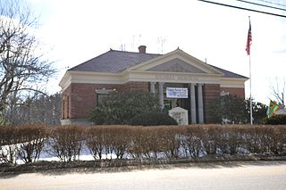
Chichester is a town in Merrimack County, New Hampshire, United States. The population was 2,665 at the 2020 census.

<span class="mw-page-title-main">Epsom, New Hampshire</span> Town in New Hampshire, United States

Epsom is a town in Merrimack County, New Hampshire, United States. The population was 4,834 at the 2020 census.

<span class="mw-page-title-main">Pembroke, New Hampshire</span> Town in New Hampshire, United States

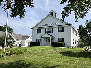
Pembroke is a town in Merrimack County, New Hampshire, United States. The population was 7,207 at the 2020 census. Pembroke includes part of the village of Suncook. The center of population of New Hampshire is close to the Pembroke town center.

<span class="mw-page-title-main">South Hooksett, New Hampshire</span> Census-designated place in New Hampshire, United States

South Hooksett is a census-designated place (CDP) within the town of Hooksett in Merrimack County, New Hampshire, United States. The population was 5,888 at the 2020 census. It is a suburban area adjacent to the city of Manchester, New Hampshire's largest city, and includes a mix of housing developments and large retail stores.

<span class="mw-page-title-main">Suncook, New Hampshire</span> Census-designated place in New Hampshire, United States

Suncook is a census-designated place (CDP) in Merrimack County, New Hampshire, United States. The population was 5,501 at the 2020 census. Approximately two-thirds of Suncook is located in the town of Pembroke, with the remainder in Allenstown.

<span class="mw-page-title-main">Auburn, New Hampshire</span> Place in New Hampshire, United States

Auburn is a town in Rockingham County, New Hampshire, United States. The population was 5,946 at the 2020 census, up from 4,953 at the 2010 census.

<span class="mw-page-title-main">Candia, New Hampshire</span> Place in New Hampshire, United States

Candia is a town in Rockingham County, New Hampshire, United States. The population was 4,013 at the 2020 census. The town includes the villages of Candia, Candia Four Corners and East Candia.

<span class="mw-page-title-main">Chester, New Hampshire</span> Town in New Hampshire, United States

Chester is a town in Rockingham County, New Hampshire, United States. The population was 5,232 at the 2020 census, up from 4,768 at the 2010 census. It was home to the now defunct Chester College.

<span class="mw-page-title-main">Deerfield, New Hampshire</span> Town in New Hampshire, United States

Deerfield is a town in Rockingham County, New Hampshire, United States. The population was 4,855 at the 2020 census, up from 4,280 in 2010. Deerfield is the location of the annual Deerfield Fair.

<span class="mw-page-title-main">Hooksett (CDP), New Hampshire</span> Census-designated place in New Hampshire, United States

Hooksett is a census-designated place (CDP) in the town of Hooksett in Merrimack County, New Hampshire, United States. The CDP includes the historic central village of Hooksett as well as suburban and rural land surrounding it. The population of the CDP was 5,283 at the 2020 census, out of 14,871 in the entire town.

<span class="mw-page-title-main">Hooksett, New Hampshire</span> Town in New Hampshire, United States

Hooksett is a town in Merrimack County, New Hampshire, United States. The population was 14,871 at the 2020 census, up from 13,451 at the 2010 census. The town is located between Manchester, the state's largest city, and Concord, the state capital. A prominent landmark is Robie's Country Store, a National Historic Landmark and a frequent stop for presidential candidates during the New Hampshire primary.

<span class="mw-page-title-main">Pittsfield, New Hampshire</span> Town in New Hampshire, United States

Pittsfield is a town in Merrimack County, New Hampshire, United States. The population was 4,075 at the 2020 census.

<span class="mw-page-title-main">New Hampshire Route 28</span> State highway in eastern New Hampshire, US

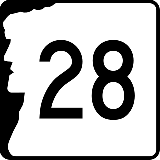
New Hampshire Route 28 is an 85.413-mile-long (137.459 km) north–south state highway in eastern New Hampshire. It connects the town of Ossipee in east-central New Hampshire with Salem on the Massachusetts border, while passing through Manchester, the largest city in the state.

<span class="mw-page-title-main">Suncook River</span> River in New Hampshire, United States

The Suncook River is a 35.7-mile-long (57.5 km) river located in central New Hampshire in the United States. It is a tributary of the Merrimack River, which flows to the Gulf of Maine.

Bear Brook is a 10.0-mile-long (16.1 km) stream located in central New Hampshire in the United States. It is a tributary of the Suncook River, part of the Merrimack River watershed. Its entire course is within Bear Brook State Park.

<span class="mw-page-title-main">Merrimack Valley</span> Region in the U.S. states of New Hampshire and Massachusetts

The Merrimack Valley is a bi-state region along the Merrimack River in the U.S. states of New Hampshire and Massachusetts. The Merrimack is one of the larger waterways in New England and has helped to define the livelihood and culture of those living along it for millennia.

<span class="mw-page-title-main">2018 New Hampshire Executive Council election</span>

The 2018 New Hampshire Executive Council elections were held on November 6, 2018 to elect all five members of the Executive Council of New Hampshire. The party primaries were held on September 11.

References

  1. 1 2 "2021 U.S. Gazetteer Files – New Hampshire". United States Census Bureau. Retrieved December 13, 2021.
  2. 1 2 3 "Allenstown town, Merrimack County, New Hampshire: 2020 DEC Redistricting Data (PL 94-171)". U.S. Census Bureau. Retrieved December 13, 2021.
  3. United States Census Bureau, U.S. Census website, 2010 Census figures. Retrieved March 23, 2011.
  4. Fogg, Alonso J. (1875). Statistics and Gazetteer of New-Hampshire. Concord, N.H.: D.L. Guernsey. p. 50. Retrieved December 13, 2021.
  5. Hardy, Charles R. "Town of Hooksett Brief History: Introduction". Archived from the original on July 20, 2011. Retrieved February 18, 2011.
  6. "Merrimack County History and Genealogy" . Retrieved February 18, 2011.
  7. "A Brief History of Allenstown" (PDF). Allenstown Historical Society. Archived (PDF) from the original on August 16, 2016. Retrieved December 13, 2021.
  8. 1 2 Martel, Carol (2008). Suncook Village. Arcadia. ISBN   9780738557526.
  9. "Suncook, NH".
  10. "Money for flood victims in Allenstown surprising". NH Business Review. September 9, 2008. Retrieved December 13, 2021.
  11. Foster, Debra H.; Batorfalvy, Tatianna N.; Medalie, Laura (1995). Water Use in New Hampshire: An Activities Guide for Teachers. U.S. Department of the Interior and U.S. Geological Survey.
  12. "New Hampshire GRANIT database: Conservation Lands". Archived from the original on June 7, 2008. Retrieved June 5, 2008.
  13. "Census of Population and Housing". Census.gov. Retrieved June 4, 2016.
  14. "U.S. Census website". United States Census Bureau . Retrieved January 31, 2008.